Luigi Amedeo, his 1906 Rwenzori Expedition, and the Legacy Written in Stone
This is the full story of Luigi Amedeo, Duke of Abruzzi, his 1906 Rwenzori expedition, the team that reached Margherita Peak, and the legacy they left on Africa’s third-highest summit.
Every mountain has a first time. A first set of human footprints on its summit marks the moment when the world, which has been turning for four billion years without any particular awareness of the mountain in question, acquires a new fact in its inventory: this peak has been reached, this height has been measured by human legs and lungs, and this place now has a name. For Margherita Peak, Africa’s third-highest summit at 5,109 meters on the crown of Mount Stanley in the Rwenzori Mountains of western Uganda, the first time was the 18th of June, 1906. The man responsible was Luigi Amedeo Giuseppe Maria di Savoia-Aosta, Prince of Savoy, Duke of Abruzzi, nephew of the King of Italy, and one of the finest mountaineers the nineteenth and early twentieth centuries produced.

He was thirty-two years old when he stood on that summit. He had already reached the highest point on the North American continent, climbed some of the most dangerous faces in the Alps, and set a furthest-north record in the Arctic. He came to the Rwenzori not because there was nothing left to climb he was Italian royalty in the age of empire; he could have done almost anything but because this particular range, this particular mountain, this particular cloud-wrapped puzzle of peaks on the equator, had not yet been solved. The Duke of Abruzzi came to the Rwenzori Mountains because they were there and because no one else had yet had the organization, the resources, and the determination to get to the top of them.
This article covers the Duke’s life, his team, their Rwenzori journey, their summit, and what they left behind. It is a story that every trekker who walks toward Margherita Peak today is, in some sense, continuing. The mountain has not changed. The same glacier, smaller now but still present, still demands the same crampons and rope. The same pre-dawn cold bites in the same way at the same elevation. Standing at what is now Margherita Camp, at 4,485 meters, and looking up at the ice, you are in the same place where Luigi Amedeo stood the night before his summit. That is not a metaphor. It is literally true.
Luigi Amedeo: A Prince Drawn to the Edges of the World
Luigi Amedeo was born on the 29th of January, 1873, in Madrid, the third son of Prince Amedeo, Duke of Aosta, who was briefly King of Spain, and Princess Maria Vittoria dal Pozzo. His father’s brief and turbulent reign ended before Luigi Amedeo was two years old. Amedeo abdicated in 1873, finding the Spanish political situation ungovernable, and the family returned to Italy. Luigi Amedeo grew up in the Italian royal household, a prince of the House of Savoy in a newly unified Italy still constructing its national identity and very much in the business of proving itself against the older, more established powers of Europe.
He joined the Italian Navy at age fifteen and proved a gifted sailor and naval officer, advancing quickly through the ranks. But it was in the mountains, not at sea, that he found his deepest vocation. He began climbing in the Alps in his early twenties, and his progression was rapid. In 1897, at the age of twenty-four, he made the first ascent of the north face of the Aiguille du Géant in the Mont Blanc massif, a technically demanding climb that established his reputation among Alpine guides and mountaineers as someone with genuine ability rather than aristocratic dilettantism. He was not a wealthy man playing at climbing. He was a trained, technically skilled mountaineer who also happened to be a prince.
The Arctic Record and the American Summit
In 1899, Luigi Amedeo led an expedition to the Arctic aboard a converted Norwegian vessel, the Stella Polare. The expedition was intended to reach the North Pole, an objective that remained beyond human reach until Peary’s contested 1909 claim, but it achieved something of permanent value: on April 25, 1900, Captain Umberto Cagni, a member of the Duke’s team, reached latitude 86°34′ North, breaking Nansen’s 1895 furthest-north record by a substantial margin. The Duke himself remained behind at the base camp, having suffered severe frostbite during the expedition that cost him the tips of three fingers on his left hand. The expedition was considered a success despite not reaching the pole, and it established Luigi Amedeo’s credentials as an expedition leader of the highest order: organized, methodical, prepared for catastrophic conditions, and capable of making difficult decisions under pressure.
In 1897, between his Alpine career and the Arctic expedition, Luigi Amedeo made the first ascent of Mount St. Elias on the Alaska-Canada border at 5,489 metres, then believed to be the highest peak in North America. The ascent, accomplished in June of that year, required the team to travel through some of the most technically demanding glaciated terrain in the world. It was on this expedition that the Duke first worked with the guides and high-altitude porters whose skills he would come to rely on completely: specifically, the Courmayeur guides from the Val d’Aosta, the family clans of mountain professionals who had been leading ascents in the Western Alps for generations. He would bring the best of them to the Rwenzori nine years later.
📜 Historical NoteLuigi Amedeo’s 1897 St. Elias ascent was accomplished with a party that included his cousin Prince Luigi of Savoy and the American scientist Israel Russell, among others. The organization of that expedition, its meticulous supply logistics, its use of professional Alpine guides, and its systematic photographic documentation were a template he would refine and apply to every subsequent expedition. By the time he reached the Rwenzori in 1906, Luigi Amedeo had essentially invented the modern high-altitude expedition methodology: professional guides, scientific staff, a dedicated photographer, a systematic supply chain, and a leader who understood both the mountain and the men. |
The Rwenzori Before the Duke: A Mountain Range That Defied Definition
To understand the magnitude of what the Duke of Abruzzi accomplished in 1906, it is necessary to understand what the Rwenzori Mountains were to the outside world before his arrival, which is to say, a rumor, a geographical mystery, and a theoretical resolution to one of history’s most persistent cartographic puzzles.
The ancient Greek geographer Ptolemy, writing in the second century AD, described mountains at the heart of Africa as the source of the Nile, the ‘Mountains of the Moon,’ he called them, reasoning from the reports of merchants and travelers who had never seen the range themselves. For seventeen centuries after Ptolemy, the question of whether such mountains existed, and where exactly they were, and what they looked like, was essentially unanswerable. The Rwenzori Range sits in the heart of the continent, hidden by equatorial forest, perpetually wrapped in cloud, and invisible from the surrounding plains on most days of the year. The Bakonzo people, who have lived in the shadow of these mountains for centuries and called them ‘Rwenzori,’ a name meaning approximately ‘Rain Maker,’ knew them intimately, but their knowledge was not recorded in the cartographic tradition that European geographers relied upon.
It was Henry Morton Stanley who brought the Rwenzori into the world’s cartographic consciousness. On his Emin Pasha Relief Expedition of 1887-1889, Stanley passed through the region to the north of the range and saw, one morning, what he first thought were clouds a mass of white that he gradually recognized, over several days of observation, as snow. Snow on the equator. Snow in tropical Africa. He wrote about it in his expedition account, and the world paid attention. The legendary mountains of Ptolemy were real. They existed. They had been seen. But they had not been climbed.
The First Approaches: Stairs, Scott Elliot, and Moore
Between Stanley’s 1889 sighting and the Duke’s 1906 expedition, several European explorers attempted to penetrate the Rwenzori range with varying degrees of success. In 1891, G. F. Scott Elliot reached elevations above the forest zone and made important botanical and geological observations. The Scott Elliott Pass, a significant landmark on the Central Circuit Trail and the approach to Margherita Peak today, bears his name in recognition of that early penetration of the high range. In 1900, the English traveler Halford Mackinder attempted the range. Odoardo Beccari, an Italian botanist, conducted additional botanical expeditions to the lower zones in 1905. None of these earlier visitors, however, had the organization, the equipment, or the mountaineering expertise to attempt the actual summits. The Rwenzori was botanically cataloged, partially mapped, and scientifically recognized, but its highest peaks were unclimbed.
🌿 Guide PerspectiveWhen I guide trekkers along the Central Circuit Trail today and we cross the Scott Elliott Pass on the approach to Margherita Peak, I sometimes contemplate what that pass meant to Scott Elliot in 1895 and what it meant to the Duke of Abruzzi in 1906. For Elliot, it was as far as a European had gone. For the Duke, it was the gateway to the summit. Both perspectives are visible from the same point. The mountain has room for both. |
The 1906 Expedition: Organisation, Preparation, and Arrival
The Duke of Abruzzi began planning his Rwenzori expedition in late 1905, following the pattern of meticulous preparation that had characterized his Arctic and Alaskan expeditions. He was motivated by specific, concrete goals: not merely to reach the highest peaks but to produce the definitive scientific and cartographic record of the range. He intended to measure every significant peak, map every valley and glacier, document every significant plant community, and bring back a photographic record thorough enough to serve as a permanent scientific reference. This was not mountaineering as recreation. It was mountaineering as a scientific expedition.
Assembling the Team
The team the Duke assembled for the Rwenzori was exceptional by any standard. Its scientific members included Dr. Filippo De Filippi, who would later write the definitive published account of the expedition; Dr. Nino Negrotto, who handled much of the cartographic and survey work; Dr. Giuseppe Cavalli-Molinelli, the expedition’s physician; and two zoologists whose fieldwork would yield specimens and observations of the Rwenzori’s extraordinary endemic fauna. The Duke understood that a scientific expedition without genuine scientists was merely tourism.
The technical mountaineering staff were drawn from the Val d’Aosta guides who had been serving the Duke for years. Joseph Petigax, who had guided the Duke’s Alaskan ascent of Mount St. Elias in 1897, was the lead guide, a man of profound alpine experience and unshakeable steadiness at altitude. His son Laurent Petigax came as his climbing partner. César Ollier, from a different Courmayeur guiding family, was the third professional guide. Joseph Brocherel completed the guide team. These were not porters or general mountain staff; they were technical experts whose specific skill was the management of glacier and rock terrain in dangerous conditions. The Duke placed his life in their hands, and his trust proved well-founded.
And then there was Vittorio Sella.
Vittorio Sella: The Man Who Photographed the Mountain
Vittorio Sella was, quite simply, the finest mountain photographer the nineteenth century produced and one of the finest in the history of the discipline. Born in Biella in 1859 and trained as a photographer by his uncle Quintino Sella, a founding member of the Italian Alpine Club, he had spent his professional life climbing mountains, specifically to photograph them. By 1906 his work encompassed the Alps, the Caucasus, the Himalayas, the Arctic, and Alaska, where he had accompanied the Duke’s 1897 St. Elias expedition. The expedition’s photographs, produced by Sella, gained widespread publication and became the visual record of the North American high mountains for a generation.
The Duke brought Sella to the Rwenzori because he understood that photographs were the primary medium through which the expedition’s discoveries would reach the world. Sella used large-format glass plates, requiring a heavy wooden camera and an even heavier system of chemicals and processing equipment, a burden that the expedition’s African porters would have to carry up through five vegetation zones to the high camps. Sella produced approximately 220 photographs during the Rwenzori expedition, and they remain, more than a century later, the most important visual record of the range before the current era. The glacier extents he documented in 1906 provide the baseline against which current climate scientists measure the Rwenzori’s catastrophic ice loss.
| Name | Role | Significance |
| Luigi Amedeo, Duke of Abruzzi | Expedition Leader | Italian prince, veteran of Arctic and Alaska; organised and led the entire expedition |
| Dr. Filippo De Filippi | Scientific lead / historian | Wrote the definitive published account of the expedition; zoological and botanical records |
| Dr. Nino Negrotto | Cartography & survey | Produced the first accurate maps of the Rwenzori peaks and glacier systems |
| Dr. G. Cavalli-Molinelli | Expedition physician | Medical support; altitude management and tropical disease preparedness |
| Joseph Petigax | Lead Alpine guide | Val d’Aosta guide; veteran of Duke’s 1897 Alaska expedition; managed glacier sections |
| Laurent Petigax | Alpine guide | Son of Joseph Petigax, experienced glacier and rock technician |
| César Ollier | Alpine guide | Courmayeur professional guide: expert on mixed rock and ice terrain |
| Joseph Brocherel | Alpine guide | Fourth professional guide; rope management and camp establishment |
| Vittorio Sella | Expedition photographer | Greatest mountain photographer of the era; 220+ glass-plate photographs; definitive visual record |
Arrival in Africa and the Approach to the Range
The expedition departed from Italy in late April 1906 and reached the east coast of Africa, traveling by ship to Mombasa and then by rail on the newly completed Uganda Railway to Kampala. From Kampala, they proceeded to Toro Kingdom in western Uganda, the administrative district closest to the Rwenzori range, and arrived at the mountain’s base in late May. The total travel time from Italy to the foothills of the Rwenzori was approximately four weeks, a journey that today’s trekkers cover in a single long-haul flight.
The approach conditions the expedition encountered were consistent with what every guide who has led the Central Circuit Trail or the Kilembe Trail knows from personal experience: the Rwenzori received them with rain, mist, and trails that had been transformed by the wet season into extended bogs. De Filippi’s published account, ‘Ruwenzori: An Account of the Expedition of H.R.H. Prince Luigi Amedeo of Savoy, Duke of the Abruzzi,’ published in English in 1908, describes the approach as a sustained exercise in managing terrain that was simultaneously beautiful and impassable. The porters, recruited from the local Bakonjo community the same community whose descendants serve as guides and porters on all Rwenzori treks today were essential to the expedition’s progress. The expedition could not have moved the equipment without their assistance. Without the Bakonzo knowledge of the mountain’s lower sections, the team would have spent weeks simply finding the right route.
The Vegetation Zones: A World Neither the Duke Nor His Scientists Had Expected.
One of the recurring themes in De Filippi’s expedition account is the genuine astonishment of the scientific team at the biodiversity of the Rwenzori’s vegetation zones. The zoologists and botanists had come expecting a mountain. They found an ecosystem of unmatched strangeness. The giant lobelias in the alpine moorland zone, which the expedition reached above 3,500 metres elicited an extended description in De Filippi’s account: plants standing two metres tall, their spiraling leaf towers collecting water in rosettes large enough to shelter from, in a landscape that looked, as one team member reportedly said, like something from a world that had not yet decided what its plant life should look like. The giant groundsels drew equal astonishment. The forest below, with its Colobus monkeys and extraordinary birdlife, provided material for the zoologists. Sella photographed everything.
The five vegetation zones that the expedition passed through on the way to the high camps the Afro-Montane Forest, the Bamboo-Mimulopsis zone, the Heather-Rapanea zone, the Afro-Alpine moorland, and the Nival zone of bare rock and ice are exactly the same five zones that trekkers on the Rwenzori’s main routes pass through today. The mountain has not changed. Only the glaciers, which Sella photographed at their full 1906 extent, have retreated.
📜 From De Filippi’s AccountThe published expedition account describes arriving in the heather zone as entering a world “of absolute strangeness”: trees twenty feet high covered in moss so thick it absorbed footsteps, trunks wrapped in lichens of a dozen colors, and the ground itself invisible beneath a carpet of sodden plant material. De Filippi noted that the guides, who were accustomed to the Alps and Alaska, found the lower sections of the Rwenzori harder going than any glacier. The mud and the biological density of the forest zones were more disorienting than altitude. |
The Summit Campaign: Establishing Camps and Reaching the High Peaks
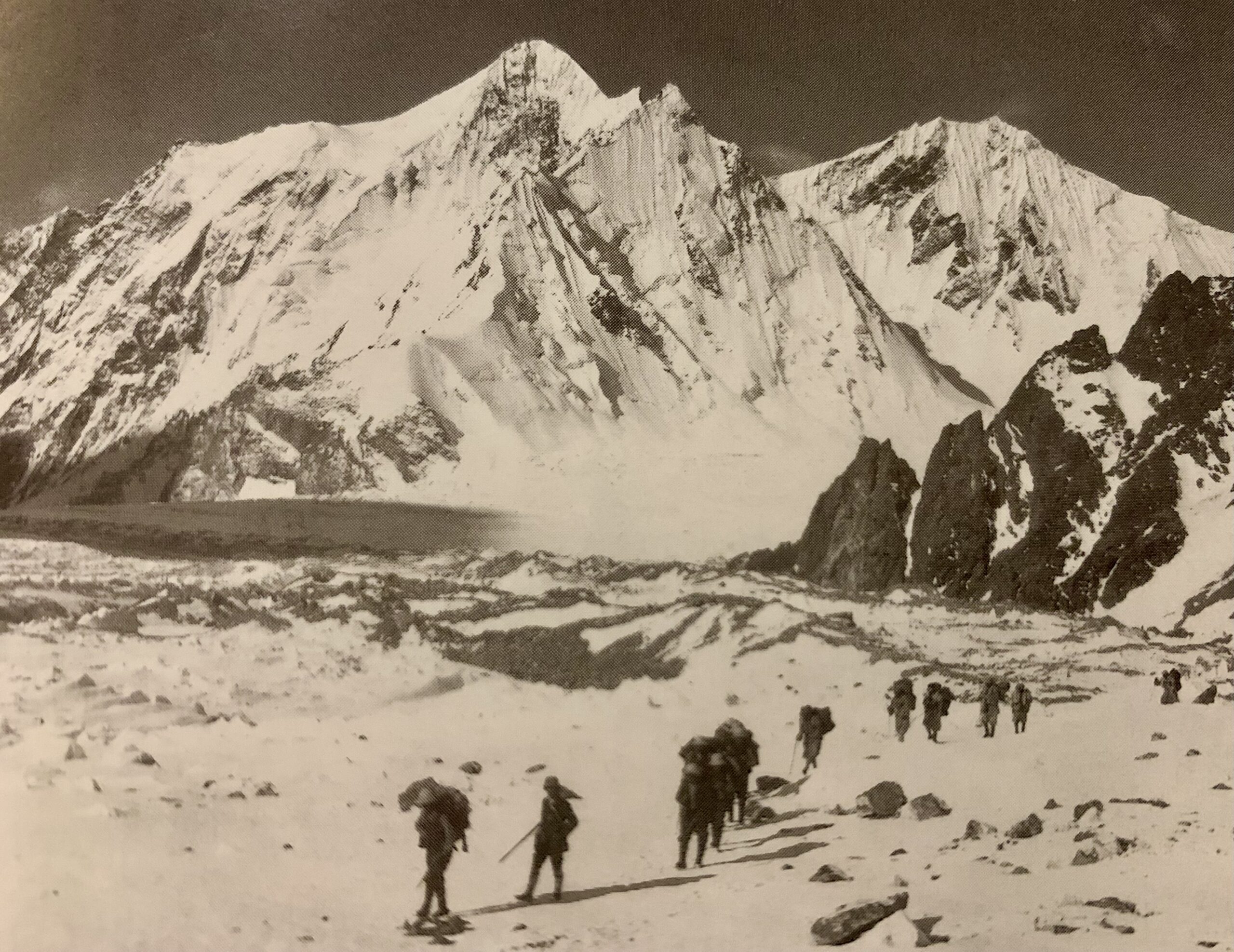
The expedition set up its main high camp at what is now called Margherita Camp, located on a rocky ledge about 4,485 meters high, protected by large boulders below the upper slopes of Mount Stanley. This camp serves as the base before the final climb to the summit. The choice of this spot, which is shielded from the wind, allows for a direct route to the glacier and is high enough to reach the summit in one day, shows the smart planning that Joseph Petigax and his fellow guides used in their approach.
The glacier travel on the upper mountain was the most technically demanding section of the approach, as it is for every summit party today. The Duke’s team used crampons, a technology that was still relatively new in 1906 and not universally employed by mountaineers of the era, and fixed ropes on the steeper sections. The guides cut steps in the ice with their ice axes where the slope angle required it. Petigax’s management of the glacier route was the professional heart of the summit attempt: knowing which line across the Stanley Glacier avoided the crevasse zones, where to place anchors on the exposed sections, and how to manage the pace of a roped team on steep ice. These are precisely the skills that the guides of Rwenzori Trekking Safaris apply on the same glacier today.
The First Ascent: June 18, 1906
On the 18th of June, 1906, the Duke of Abruzzi, accompanied by the guides Petigax, Ollier, and Brocherel, left the high camp before dawn and made their way up through the glacier to the summit ridge of Mount Stanley. The exact departure time is not recorded in De Filippi’s account with the specificity that modern expedition notes would provide, but the description of the ascent darkness on the glacier, the first light arriving as they gained elevation, and the cloud building from the Congo basin as the morning advanced is consistent with what guides and trekkers on the same route experience today. The mountain was then, as it is now, one that opened its best summit window in the pre-dawn hours and closed it firmly by late morning.
The summit was reached in the late morning. De Filippi, who was not with the summit party, records the report of the guides and the Duke: at 5,109 metres, on a narrow rocky crest above the glacier, in the cloud that had by then built sufficiently to obscure the view in most directions, Luigi Amedeo stood on the highest point in Uganda and one of the highest points in Africa. The flag planted on that summit was Italian. The name given to the peak was Italian: Margherita, in honor of Queen Margherita of Savoy, the Italian queen who had given her name to a pizza and would now give it to a mountain.
The same summit party, over the following days, went on to make the first ascents of the other major peaks of the Stanley massif: Alexandra Peak at 5,091 metres, named after Prince Alexander of Belgium, and Albert Peak at 5,087 metres, named after King Albert I of Belgium. The Duke also made the first ascents of Mount Speke (at what is now known as Vittorio Emanuele Peak, 4,890 m) and Mount Baker (Edward Peak, 4,843 m), as well as several other significant summits including what is now Mount Luigi di Savoia, Weismann Peak, and others in the range. In the space of three weeks in June 1906, Luigi Amedeo accomplished the first ascents of virtually all the major summits of the Rwenzori Mountains. No other significant mountain range has achieved a comparable sweep of first ascents in such a short time, either before or after.
🌿 Guide InsightWhen you stand at Margherita Camp today, at exactly the position where the Duke of Abruzzi’s team made their camp in 1906, you are standing in the most historically significant spot in African mountaineering history. Not the summit; anyone who reaches the summit has the summit. But this camp’s location is where the first people to stand on Margherita Peak slept the night before. They looked up at the same glacier. They felt the same cold. They had the same pre-dawn darkness when they set off. The mountain kept its geometry. Only the glacier’s edge has moved. |
The Scientific Legacy: What the 1906 Expedition Left Behind
The mountaineering achievements of the 1906 expedition, extraordinary as they were, represent only one dimension of its significance. The scientific work conducted by De Filippi, Negrotto, and the expedition’s specialist naturalists produced a body of knowledge about the Rwenzori Mountains that remained the foundational reference for decades. Negrotto’s survey maps, produced with meticulous accuracy using the survey instruments the expedition had carried up through the forest and bog, gave the range its first proper cartographic representation: elevations measured, peaks named, glaciers delineated, and valleys charted. The maps remained in use, with modifications, well into the second half of the twentieth century.
The botanical and zoological collections were equally significant. The expedition’s specimens described dozens of species new to science, including several that now bear the names of its members. The expedition systematically documented the Rwenzori’s endemic flora, including giant lobelias, groundsels, heathers, and extraordinary mosses, for the first time. The expedition’s physician contributed observations on the physiological effects of altitude at equatorial latitudes, a subject that was then almost unstudied. The whole scientific package, compiled and published in the 1908 volume edited by De Filippi, gave the scientific world its first comprehensive picture of one of the most extraordinary ecosystems on the planet.
Vittorio Sella’s Photographs: A Baseline That Haunts Climate Science
Sella’s 220 glass-plate photographs from the expedition have acquired, in the century since they were taken, a scientific significance that Sella himself could not have anticipated. They show the Rwenzori’s glaciers at their 1906 extent before the era of accelerated climate change, before the twentieth century’s systematic warming. When climate scientists studying equatorial glaciers today overlay satellite imagery of current glacier extent onto Sella’s 1906 images, the comparison is stark and alarming: the Rwenzori has lost more than eighty percent of its glaciated area since Sella photographed it. The glacier that the Duke and his guides crossed on June 18, 1906, is undeniably smaller today, as evidenced by the photographs.
Sella’s images are also the primary reason that the specific location of Margherita Camp and the general character of the upper mountain route can be identified with confidence using 1906 descriptions matched against modern terrain. Sella’s photographs reveal the boulders that sheltered the Duke’s camp. They are still there. Trekkers on the 8-Day Kilembe Trail expedition sleep in tents.
After the Rwenzori: The Duke’s Later Life and Enduring Legacy
The Rwenzori expedition was not the last of Luigi Amedeo’s outstanding mountaineering achievements. In 1909, he led the most ambitious Himalayan expedition yet attempted, targeting K2, the second-highest mountain on Earth, at 8,611 meters on the Pakistan-China border. The 1909 K2 expedition did not reach the summit, and K2 would remain unclimbed until 1954. But the Duke’s team, guided by Petigax and Brocherel alongside a new team of high-altitude specialists, reached a height of approximately 7,500 metres on the mountain’s southeast ridge, a new altitude record for a summit attempt and a route section that today’s mountaineers call the Abruzzi Spur in his honor. The route eventually used for the first ascent of K2 in 1954 used the Duke’s 1909 line as its foundation.
Luigi Amedeo lived until 1933, dying in Italian Somaliland (now Somalia), where he had spent his later years attempting to develop an agricultural colony in the Horn of Africa, an endeavor that combined his practical energy with the colonial assumptions of his era and which occupied his final decades as his mountaineering career drew to its close. He was sixty years old at his death, and he died in Africa, on the continent where his greatest mountaineering legacy, the names and routes on the Rwenzori range, remained fixed into the landscape.
The mountain named after his own title, Mount Luigi di Savoia, stands at 4,627 meters in the Rwenzori range; its twin peaks (Sella Peak and Weismann Peak) bear additional names from the 1906 expedition’s personnel. Sella Peak honors Vittorio Sella directly. Weismann Peak is named after biologist August Weismann, who was honored by the Duke for his contributions to natural science, despite not being part of the expedition. The naming convention the Duke applied across the Rwenzori European royalty for the highest summits and explorers, scientists, and expedition members for the lower peaks created the nomenclature that cartographers, climbers, and trekking operators use today.
📜 Names That RemainThe peaks that the Duke named in 1906 still carry those names on every map of the Rwenzori today. European royalty, such as Margherita, Alexandra, and Albert, inspired the names of these peaks, a colonial convention that has evolved historically but remains fixed on maps. Mount Speke honors the explorer John Hanning Speke. Mount Baker honors the explorer Samuel Baker. Mount Emin honors Emin Pasha, the German-born Egyptian governor whose relief was the purpose of Stanley’s 1887 expedition. Mount Gessi honors Romolo Gessi, an Italian explorer who served in the Egyptian Sudan. Every name on the Rwenzori’s peak inventory is a chapter of Victorian and Edwardian exploration history. |
What the Duke’s Route Means to Modern Trekkers
The route that modern trekkers follow to Margherita Peak is, in its essential character, the route that the Duke of Abruzzi’s team established in June 1906. The specific trail on the ground has changed. The Central Circuit Trail was developed as a formal route in later decades, and the Kilembe Trail was not established until 2011, but the mountain logic of the approach is the same: ascend through the forest, enter the moorland, cross the high passes, camp below the glacier, and make the pre-dawn push to the summit. The Duke’s guides worked out that logic. Everything since has been refinement.
The camp at 4,485 meters that the Duke’s team occupied in June 1906 is the one that every modern summit party uses tonight. The glacier above it has the same general character that Petigax navigated, though it has retreated significantly. The fixed ropes on the most exposed sections of the summit ridge reflect the same risk assessment that Petigax made when he selected the climbing line in 1906. The crampons and ice axes that trekkers carry today are technologically improved versions of the ones the guides used. The pre-dawn departure, the careful rope management, and the weather-window discipline all of it traces back, in an unbroken line of practical mountain knowledge, to what the Duke of Abruzzi’s team worked out in a week of summit attempts in June 1906.
Standing on Margherita Peak today means standing where Luigi Amedeo stood. The glacier that surrounds the summit has retreated. Sella’s photographs show how much, but the summit rock itself, the 5,109-meter highpoint of Uganda and the third-highest mountain in Africa, is unchanged. The view from it on a clear morning, with the cloud filling the Congo basin to the west and the Rwenzori range visible in its full extent to the south and east, is the view the Duke saw. That is one of the Rwenzori’s most extraordinary qualities as a mountaineering destination: it connects its modern trekkers, directly and without mediation, to one of the greatest single chapters in the history of exploration.
Frequently Asked Questions: The Duke of Abruzzi and the 1906 Rwenzori Expedition
Who was the Duke of Abruzzi, and what was his full name?
The Duke of Abruzzi’s full name was Luigi Amedeo Giuseppe Maria di Savoia-Aosta, born on January 29, 1873, in Madrid. He was a prince of the Italian royal House of Savoy, the nephew of King Umberto I of Italy, and held the title Duke of Abruzzi within the Italian peerage. He served as a naval officer in the Italian Navy and rose to the rank of admiral, but his lasting reputation is as one of the finest mountaineers and polar explorers of the late nineteenth and early twentieth centuries. Before his 1906 Rwenzori expedition, he had made the first ascent of Mount St. Elias in Alaska (1897), set a furthest-north Arctic record via the Stella Polare expedition (1899-1900), and built an international reputation as an expedition organizer of the highest order. He died on March 18, 1933, in Italian Somaliland, where he had spent his later years developing an agricultural settlement.
When did the Duke of Abruzzi first climb Margherita Peak?
Luigi Amedeo, Duke of Abruzzi, made the first ascent of Margherita Peak on June 18, 1906. He was accompanied by three professional Alpine guides from the Val d’Aosta: Joseph Petigax, César Ollier, and Joseph Brocherel. The summit party left their high camp at what is now known as Margherita Camp (4,485 metres) before dawn and reached the summit of Margherita Peak (5,109 metres) in the late morning. The peak was named in honor of Queen Margherita of Savoy of Italy. During the same expedition, the Duke’s party went on to make the first ascents of Alexandra Peak (5,091 m) and Albert Peak (5,087 m) on the Stanley massif, as well as the highest summits of Mount Speke and Mount Baker, and several other Rwenzori peaks.
Who was in the Duke of Abruzzi’s 1906 Rwenzori expedition team?
The 1906 Rwenzori expedition was one of the best-organized and most comprehensively staffed mountain expeditions of its era. The team comprised the Duke himself as leader; Dr. Filippo De Filippi as scientific lead and expedition historian, who later wrote the 1908 published account; Dr. Nino Negrotto as cartographer and surveyor, who produced the first accurate maps of the Rwenzori peaks; Dr. Giuseppe Cavalli-Molinelli as expedition physician; two specialist zoologists and a botanist; Vittorio Sella as expedition photographer, who produced approximately 220 large-format glass-plate photographs that remain the definitive visual record of the range in the pre-climate-change era; and four professional Alpine guides from the Val d’Aosta: Joseph Petigax (lead guide), his son Laurent Petigax, César Ollier, and Joseph Brocherel. African porters were recruited from the local Bakonzo community and were essential to moving the expedition’s extensive equipment through the lower mountain zones.
Why was Margherita Peak named after Queen Margherita of Italy?
Margherita Peak was named by Luigi Amedeo, Duke of Abruzzi, in honor of Queen Margherita of Savoy, the first queen of unified Italy and wife of King Umberto I. The naming convention reflected both the Duke’s personal loyalty to the Italian royal house (of which he was a member) and the broader practice of the era, in which explorers and expedition leaders named significant geographical features after royalty, prominent patrons, and significant public figures. Queen Margherita of Savoy was a popular figure in Italy and is today perhaps best known internationally as the person after whom the Margherita pizza is said to have been named, the white, red, and green colors of the pizza’s mozzarella, tomato, and basil reflecting the Italian flag. Her name on Africa’s third-highest summit is, by any measure, the more permanent of her legacies.
What challenges did the Duke’s 1906 expedition face on the Rwenzori?
The 1906 expedition encountered the specific challenges that every Rwenzori expedition faces, amplified by the era’s technological limitations and the complete absence of any prior knowledge of the high mountain terrain. The lower approach was through dense, perpetually wet tropical forest and bamboo zones. De Filippi’s account describes the guides, accustomed to Alpine conditions, finding the lower Rwenzori harder going than any glacier they had crossed. In the vegetation zones above 3,500 meters, the giant Lobelia moorland and the Afro-alpine zone were terrains for which no alpine experience provided any preparation. The glaciers on the upper mountain were larger than today’s remnants but presented the same fundamental hazards: crevasses, serac fall zones, rapidly changing weather, and the specific difficulty of glacier travel on the equator, where the sun’s intensity makes afternoon conditions dangerous. The expedition also contended with persistent rain and mist on the approach and with the logistical challenge of moving Vittorio Sella’s heavy glass-plate photographic equipment up through terrain that barely accommodated human movement without additional loads.
What other mountains did the Duke of Abruzzi climb?
Luigi Amedeo’s mountaineering career extended well beyond the Rwenzori. His major ascents include the first ascent of the Aiguille du Géant’s north face in the Mont Blanc massif (1897); the first ascent of Mount St. Elias in Alaska (5,489 m, 1897), which was then believed to be the highest peak in North America; the Arctic Stella Polare expedition (1899-1900), during which his team set a new furthest-north record of 86°34′ North; and the 1909 K2 expedition in the Karakoram Himalaya, which reached approximately 7,500 metres on what is now called the Abruzzi Spur, the route later used for the first successful ascent of K2 in 1954. The Abruzzi Spur on K2 is named directly after him and remains, more than a century later, the most commonly used route on the world’s second-highest mountain.
Can you still follow the Duke of Abruzzi’s route to Margherita Peak today?
Yes, and this route is one of the most compelling aspects of climbing Margherita Peak today. The main path that the Duke of Abruzzi’s team created in June 1906, which goes through the forest and moorland, crosses high passes, uses what is now Margherita Camp as the base before the summit, and crosses the Stanley Glacier to reach the top, is still the foundation for all modern guided climbs of the peak. The 7-Day Central Circuit Trail and the 8-Day Kilembe Trail both converge near the high camps and use essentially the same glacier approach that Joseph Petigax engineered in 1906. The camp at 4,485 meters, used as the modern pre-summit base, is the same site the Duke occupied. The glacier above it has retreated, but the summit rock is unchanged. Trekkers who reach Margherita Peak today stand where Luigi Amedeo stood on June 18, 1906.
Follow in the Duke’s Footsteps
Luigi Amedeo, Duke of Abruzzi, chose the Rwenzori Mountains because they were the unclimbed mountains on the equator, the range that the ancients had named without seeing, the peaks that Stanley had reported without reaching, and the summit that no mountaineer had yet stood on. He chose correctly. More than a century after the Duke first walked into its forest, the Rwenzori is still one of the world’s most extraordinary mountain destinations. The summit he reached on June 18, 1906, can still be reached today by any well-prepared, physically fit trekker on the same route, in the same conditions, with the same pre-dawn darkness, the same glacier, and the same absolute absence of other trekkers that the Duke’s team experienced. The mountain has not been domesticated. The accumulated knowledge of guides who have walked it for generations has made it safer to navigate.

Whether you choose the 8-Day Kilembe Trail, the 7-Day Central Circuit, or one of the longer multi-peak expeditions via the 13-Day Six Peaks itinerary, the mountain you walk toward is the one that Luigi Amedeo claimed first. Rwenzori Trekking Safaris is ready to take you there.
The Mountain That Defied the World for Centuries Is Ready for You.
Contact us to begin planning your Rwenzori summit expedition

