Trek deep into Uganda’s Rwenzori Mountains to Bujuku Valley (3,977m). See Stanley, Speke & Baker without summiting. Full itinerary, camps, gear & FAQs included.
5-Day Rwenzori Hike to Bujuku | Rwenzori Mountaineering
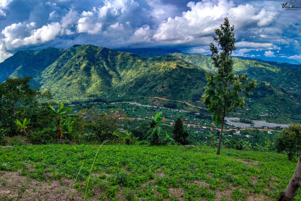
Overview of the 5-Day Rwenzori Hike to Bujuku.
Into the Heart of the Mountains of the Moon No Summit Required
Stand inside the Bujuku Valley at 3,977 m, surrounded on three sides by the towering massifs of Mount Stanley, Mount Speke, and Mount Baker, the Rwenzori’s legendary high-altitude triangle without roping onto a single glacier. This 5-day Rwenzori hike to Bujuku is the deepest non-summit trek in Uganda’s Mountains of the Moon: a journey through all the mountain’s iconic landscapes, stopping precisely where the drama is greatest.
Explore Uganda’s mystical Rwenzori Mountains with a 5-day hike to Bujjuku Camp. Witness incredible views of Mount Stanley, Mount Speke, and Mount Baker without summiting. This 5-day Rwenzori hike is perfect for those who love adventure and the natural world. This 5-day Rwenzori Trek takes you deep into the mysterious heart of the Rwenzori Mountains, a UNESCO World Heritage Site in the Bujjuku Valley. This 5-day Rwenzori hike to Bujjuku caters to those who desire to witness the majestic beauty of the mountains without the challenge of Margherita climbing.
This hike follows the well-known Central Circuit Trail through lush montane forests, bamboo groves, and alpine bogs. You’re on your way to Bujjuku Camp, located in the heart of the Rwenzori Mountains. From here in the Bujuku Valley, one can enjoy the stunning view of the distinctive Rwenzori triangle formed by Mount Stanley, Mount Speke, and Baker. Most hikers can access the trail, which offers a rare combination of peace, struggle, and breathtaking vistas. It’s an excellent opportunity to escape to a lesser-known but equally fascinating aspect of Africa’s ecology.

5-Day Bujuku Trek: At-a-Glance
| Duration | 5 days / 4 nights |
| Total Distance | ~54 km roundtrip (Nyakalengija ↔ Bujuku) |
| Maximum Elevation | 3,977 m Bujuku Hut, upper Bujuku Valley |
| Total Ascent | ~2,377 m (Nyakalengija, 1,600 m to Bujuku, 3,977 m) |
| Difficulty | Moderate to hard, suitable for fit trekkers with hiking experience |
| Trail Used | Central Circuit Trail (Rwenzori Mountains National Park) |
| Start & End Point | Nyakalengija Trailhead, 13 km from Kasese town |
| Best Months | January–February & June–August (drier windows) |
| Group Size | 1–12 trekkers (private and group departures available) |
| Accommodation | Mountain huts: Nyabitaba, John Matte, Bujuku |
| Technical Gear | No glacier equipment required, trekking only |
| Meals | All meals from Day 1 lunch through Day 5 breakfast |
| Price Indicator | Contact us for current pricing (ask about 2026 rates) |
| Park Authority | Uganda Wildlife Authority (UWA) |
| Summit Required? | No, this is a scenic valley trek, not a summit attempt |
Why Do the 5-Day Rwenzori Hike to Bujuku?
There is a question that comes up repeatedly when trekkers research the Rwenzori Mountains: “Can I experience the real Rwenzori without summiting Margherita Peak?” The honest answer is yes, and the 5-day Rwenzori hike to Bujuku is the definitive proof. This route penetrates deeper into the mountain range than any other non-summit itinerary, carrying you through every iconic ecosystem: tropical rainforest, bamboo forest, cloud-heather zone, and the full Afro-alpine moorland before depositing you in the Bujuku Valley at 3,977 m, the most dramatic mountain amphitheater in East Africa.
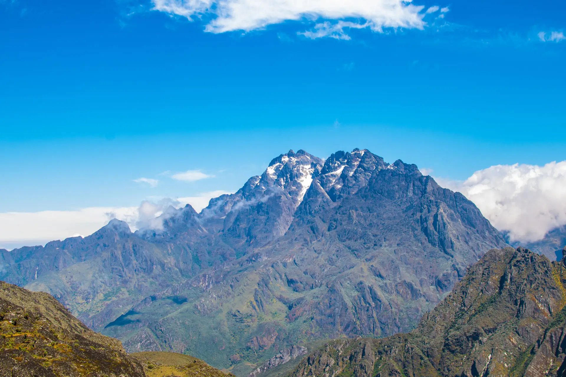
The defining moment of this trek is Day 3: arriving at Bujuku Hut in the upper Bujuku Valley and looking up. What you see from this camp is the Rwenzori triangle: Mount Stanley (5,109 m) to the west, Mount Speke (4,890 m) to the north, and Mount Baker (4,843 m) to the south three of Africa’s great peaks arranged in a horseshoe of glaciated rock and cloud. Glaciers hang visibly off each massif. The scale is humbling in a way that photographs never quite capture. This viewpoint, achievable without a single technical climbing move, is worth every muddy meter of the approach.
The pacing of the 5-day Bujuku trek makes it well-suited for a wide range of trekkers. Unlike the compressed 4-day Margherita Peak route, this itinerary has natural rest built into it. Day 1 takes you to Nyabitaba Hut (2,652 m), a manageable 8 km that allows your body to begin adjusting to altitude. Day 2 and Day 3 each add altitude progressively. Day 4 is a satisfying long descent. Day 5 is a short, gentle walk out. You are never pushed past reasonable limits, and there is time each evening to sit with the landscape, eat well, and sleep properly.
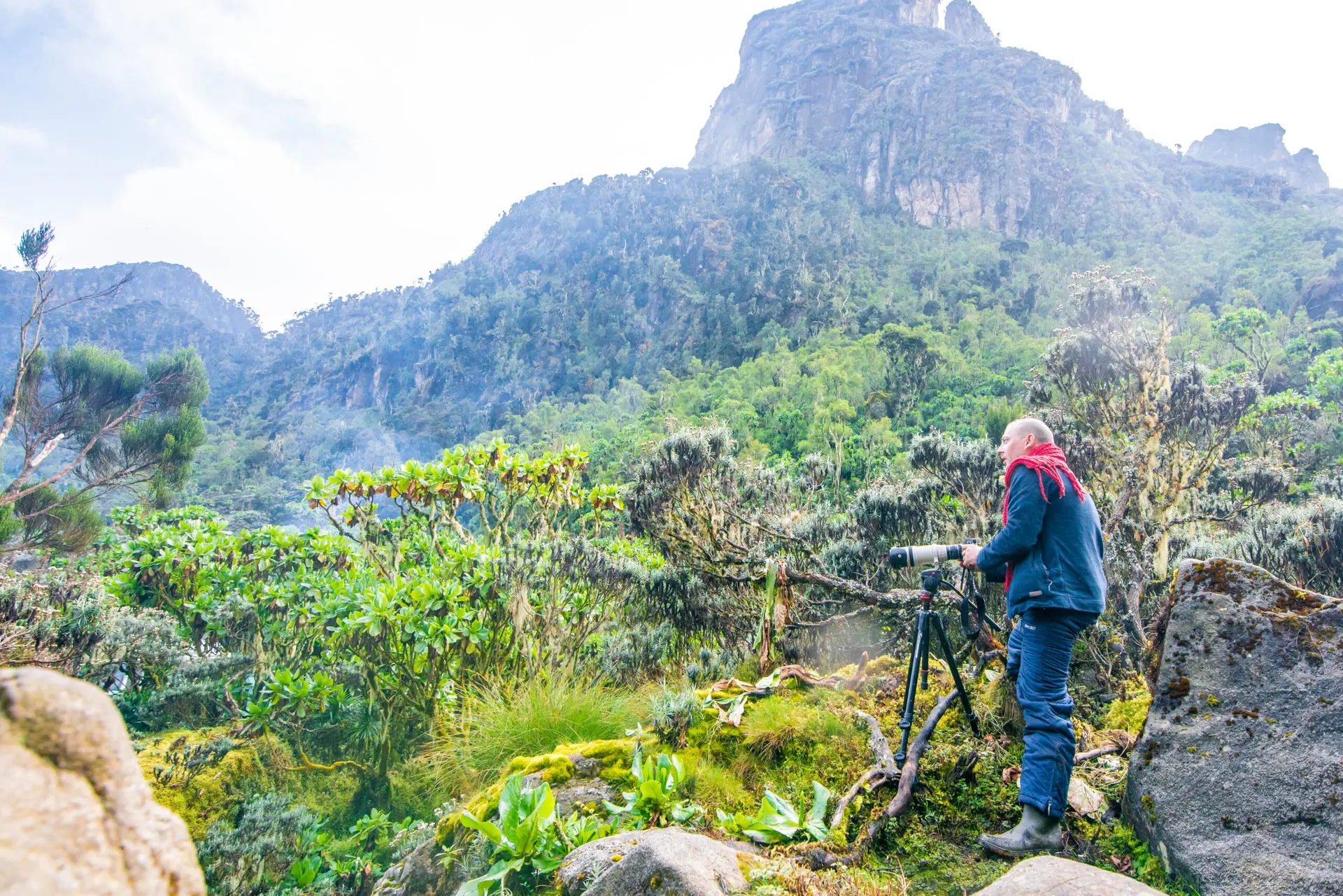
This trek is also, and we say so genuinely, one of the most ecologically astonishing short treks in Africa. The Rwenzori Mountains are a UNESCO World Heritage Site precisely because of what you encounter between 1,600m and 4,000m: Rwenzori turacos, black-and-white colobus monkeys, three-horned chameleons, giant lobelias the height of a house, ancient groundsel trees, and Lake Bujuku shimmering at 3,977 m with glacial mist rolling across its surface. If you care about wild places, truly wild places, few treks anywhere deliver this density of wonder.
Full Day-by-Day Itinerary: 5-Day Rwenzori Hike to Bujuku
DAY 1: NYAKALENGIJA → NYABITABA HUT (1,600 m → 2,652 m) | ~8 km
Hiking time: 5–6 hours | Elevation gain: +1,052 m | Overnight: Nyabitaba Hut (2,652 m)
Briefing and Departure: The Rwenzori Begins Here
Your 5-day Rwenzori hike to Bujuku starts at the Uganda Wildlife Authority (UWA) registration office in Nyakalengija, a small trailhead settlement at 1,600 m, approximately 13 kilometers northeast of Kasese. We strongly recommend arriving the evening before your departure. Guides, porters, and permit paperwork are all coordinated here, and an early morning start allows the best light on the lower forest.
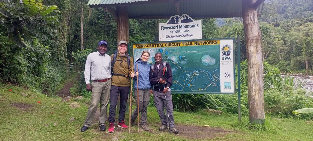
Allow 30–45 minutes for the pre-trek formalities: permits are verified, porter loads are allocated and weighed, and your lead guide delivers a route briefing covering each day’s distances, timing expectations, wildlife awareness, and the critical mountain safety rules that apply throughout the Rwenzori. This briefing is not a formality; pay close attention to the sections on altitude awareness and pacing, which are the two things that most determine the quality of your experience on the mountain.
Through the Bakonzo Foothills
The trail departs into a narrow band of Bakonzo smallholder farmland. The Bakonzo people, the indigenous mountain community who have lived in the Rwenzori foothills for generations, cultivate these terraced slopes with maize, beans, and sweet potato. You will pass homesteads, hear children’s voices from nearby fields, and occasionally be waved through by elders watching from doorways. This is one of the most culturally grounding moments of the entire trek, a reminder that the Rwenzori is not a wilderness preserved in a bubble but a living landscape that communities have shaped and inhabited for centuries.
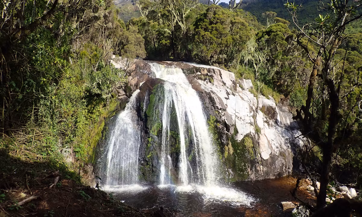
Within the first 30–45 minutes the trail enters the tropical montane forest proper. The transition is immediate: the canopy closes overhead, the temperature drops several degrees, and the noise of the agricultural zone is replaced by the calls of birds and the sound of fast-running streams. Somewhere below the trail, the Mubuku River runs, and you can hear it, but you can rarely see it through the dense understory.
The Rainforest Ascent to Nyabitaba
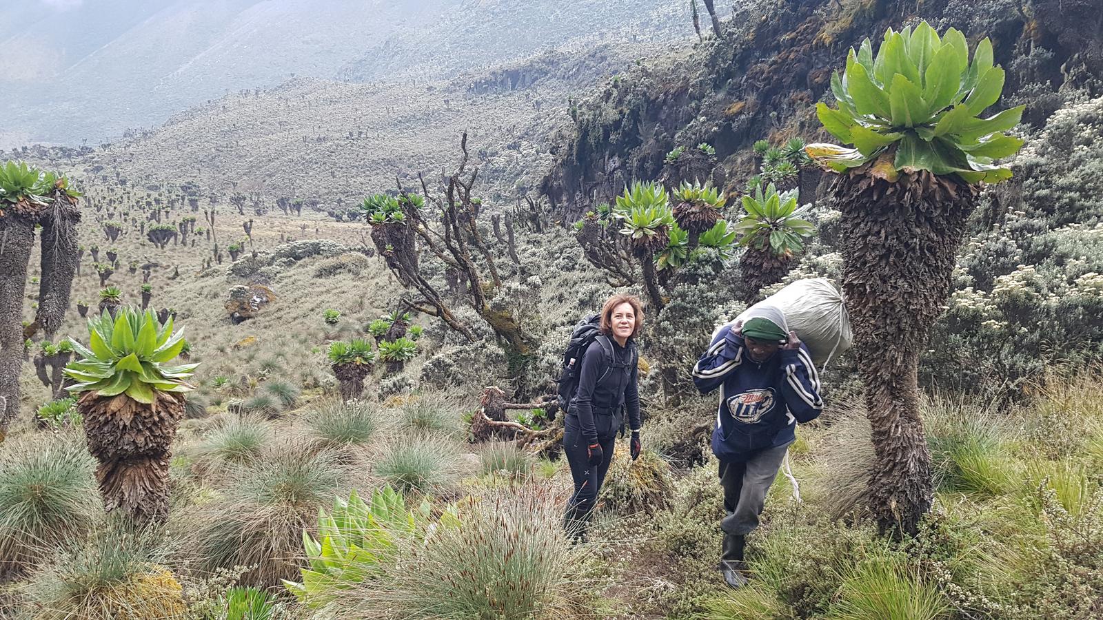
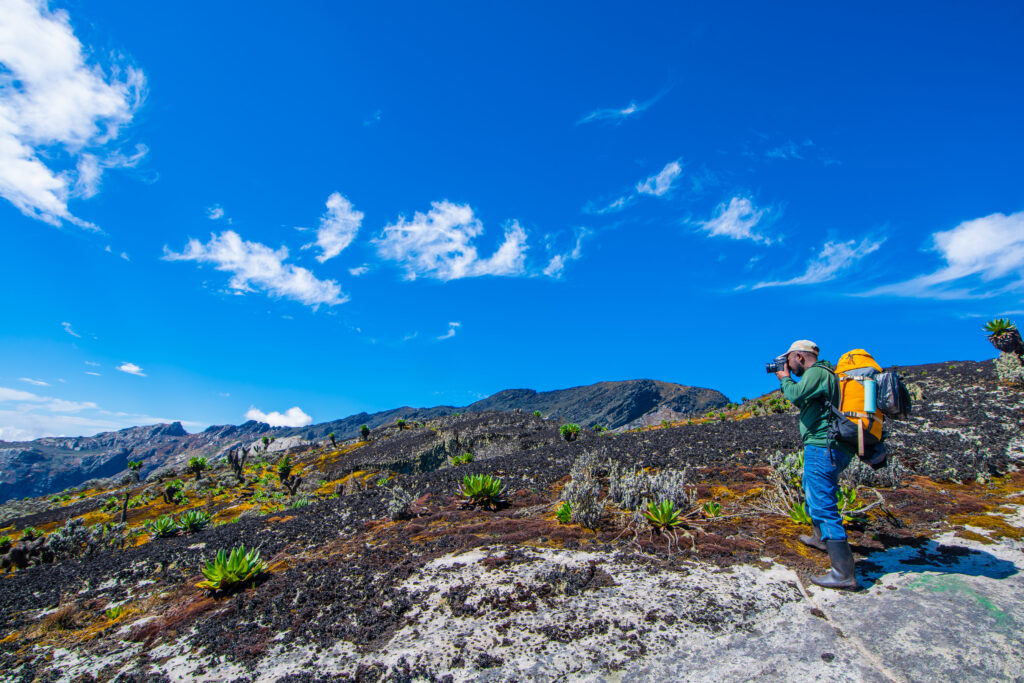
The next 3–4 hours of climbing take you through one of Uganda’s finest montane forests. Black-and-white colobus monkeys move through the canopy in family groups of 6–15 individuals, their long white cloaks catching the filtered light. Birdwatchers frequently sight the Rwenzori turaco here, especially in the early morning, with its green body and a flash of crimson wing. Rwenzori wildlife encountered on Day 1 can also include L’Hoest’s monkeys in the mid-canopy, Rwenzori olive pigeons, and the Rwenzori batis, all species found nowhere else in Uganda at this density.
The trail climbs steadily on a mix of root-bound earth and occasional stone steps. In dry conditions the going is firm; in wet conditions, which is most of the time in the Rwenzori, expect mud underfoot from the first kilometers. Rubber boots (provided free of charge) handle this environment perfectly. Your trekking poles earn their place from Day 1.
Nyabitaba Hut arrives after 5–6 hours at 2,652m. This comfortable mountain hut sits on a cleared ridge with views through the forest canopy south toward the Mubuku Valley. It is the standard first overnight on the Central Circuit Trail and a genuinely welcoming place. Dinner is a full three-course hot meal prepared by your mountain cook. The temperature at night drops to 10–14°C, which is cool but not cold. Sleep comes easily after the day’s climb.
Day 1 Highlights
- Departure briefing at Nyakalengija: meet your guide and porter team
- Bakonzo farmland and the transition into tropical montane forest
- Black-and-white colobus monkeys and Rwenzori turacos in the forest canopy
- Arrival at Nyabitaba Hut (2,652m) with views over the Mubuku Valley
DAY 2: NYABITABA HUT → JOHN MATTE HUT (2,652 m → 3,414 m) | ~12 km
Hiking time: 7–8 hours | Elevation gain: +762 m | Overnight: John Matte Hut (3,414 m)
The Kurt Schafer Bridge Crossing
Breakfast at 7:00 AM, departure by 7:30. Day 2 of the Rwenzori hike to Bujuku is longer and more varied than Day 1, passing through four distinct vegetation bands and crossing the famous Kurt Schafer Bridge, one of the most atmospheric landmarks on the entire trail. From Nyabitaba, the path descends briefly through the forest before arriving at the bridge.
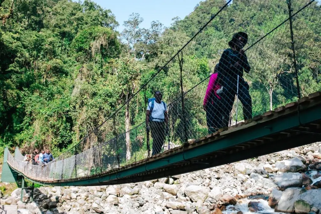
The Kurt Schafer Bridge is a narrow suspension footbridge strung across a rocky gorge where the Bujuku and Mubuku rivers meet. The rivers below crash between boulders. Mossy walls of rock rise on either side; tree ferns lean over the crossing. It is the type of place that compels one to pause on the bridge to take in the view. On the other side, the trail bends left and immediately steepens; the Rwenzori now begins to work for real.
Into the Bamboo Zone
Beyond the bridge, the character of the vegetation changes markedly. The trail climbs into the mountain bamboo zone (Arundinaria alpina), a dense stand of tall culms that creates a green tunnel effect as you ascend. Light filters through in shifting beams; the understory is thick with mosses, orchids, and wet ferns. The bamboo zone in the Rwenzori is a transition environment, part forest, part alpine, and it is frequently where you encounter wildlife moving between feeding zones. L’Hoest’s monkeys are commonly seen here, and three-horned chameleons (Trioceros johnstoni), a Rwenzori endemic, are sometimes spotted on branches at eye level. Take your time in this section; the wildlife spotting potential is excellent.
Upper Forest and the Approach to John Matte
Above the bamboo, the forest opens into lower montane heath with gnarled trees and heather draped in Usnea lichen, giving the landscape an increasingly ancient and otherworldly character. The trail steepens significantly in the final approach to John Matte Hut, and by this point in the day, most trekkers are feeling the first effects of altitude: a slight breathlessness on steep sections and perhaps a mild headache. This phenomenon is entirely normal and expected at 3,000m+.
John Matte Hut sits at 3,414m in a broad clearing at the transition between upper montane forest and the first true alpine zone. Named after a legendary Rwenzori mountain guide, the hut sleeps 16 in tiered bunks with a separate kitchen and dining shelter. On clear evenings, the first views of the high peaks appear over the valley ahead, tantalizing glimpses of what tomorrow holds. Dinner at 7:00 PM, lights out by 9:00 PM. Night temperatures drop to 5–8°C; your sleeping bag earns its place tonight.
Day 2 Highlights
- The Kurt Schafer Bridge river crossing one of the trail’s most photographed landmarks
- Bamboo forest zone green tunnels, mosses, and endemic chameleons
- Transition from montane forest to lower alpine heather
- First views of high Rwenzori peaks from John Matte Hut (3,414m)
DAY 3: JOHN MATTE HUT → BUJUKU HUT (3,414 m → 3,977 m) | ~7 km
Hiking time: 4–6 hours | Elevation gain: +563 m | Overnight: Bujuku Hut (3,977 m)
The Bigo Bog: A Landscape from Another Planet
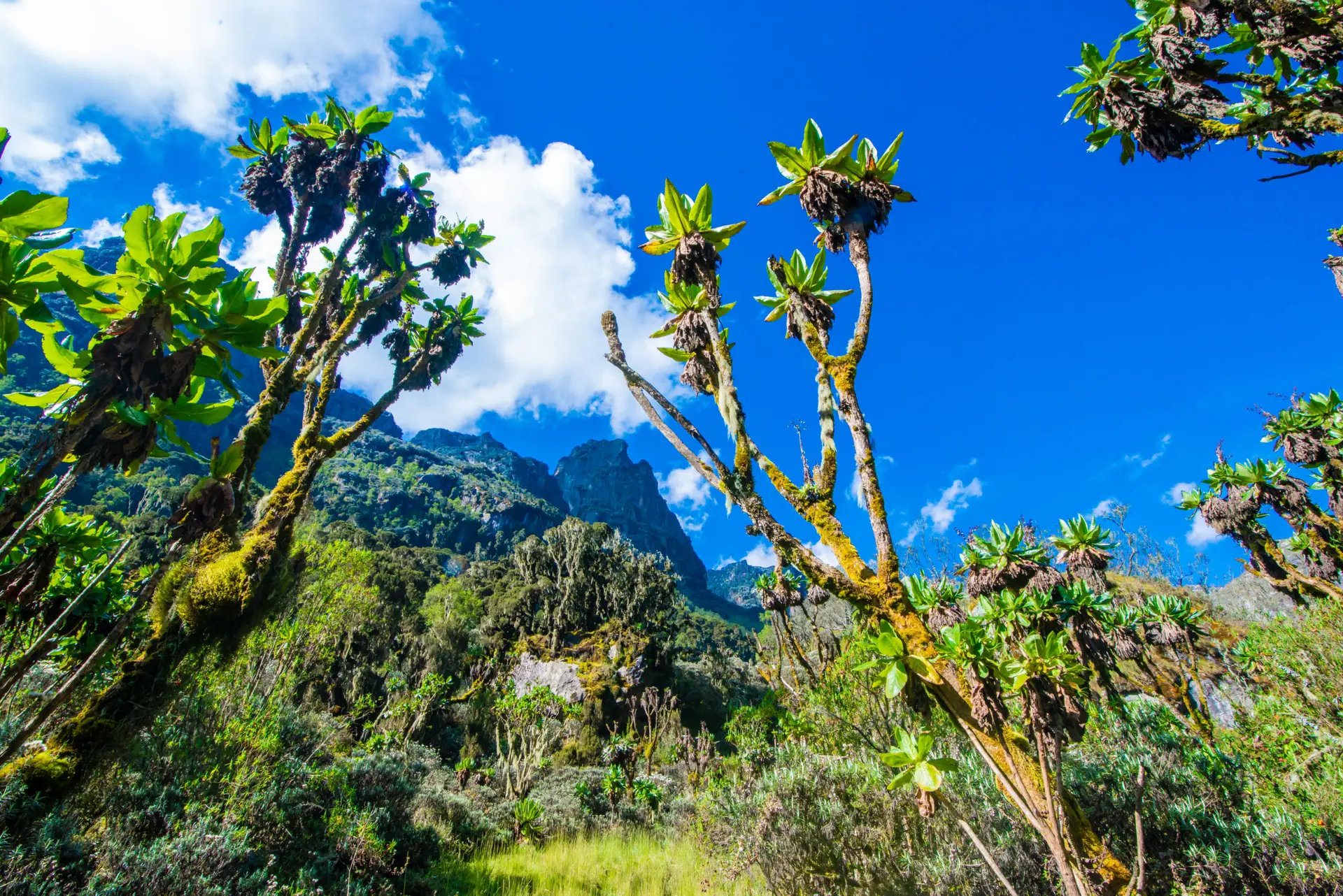
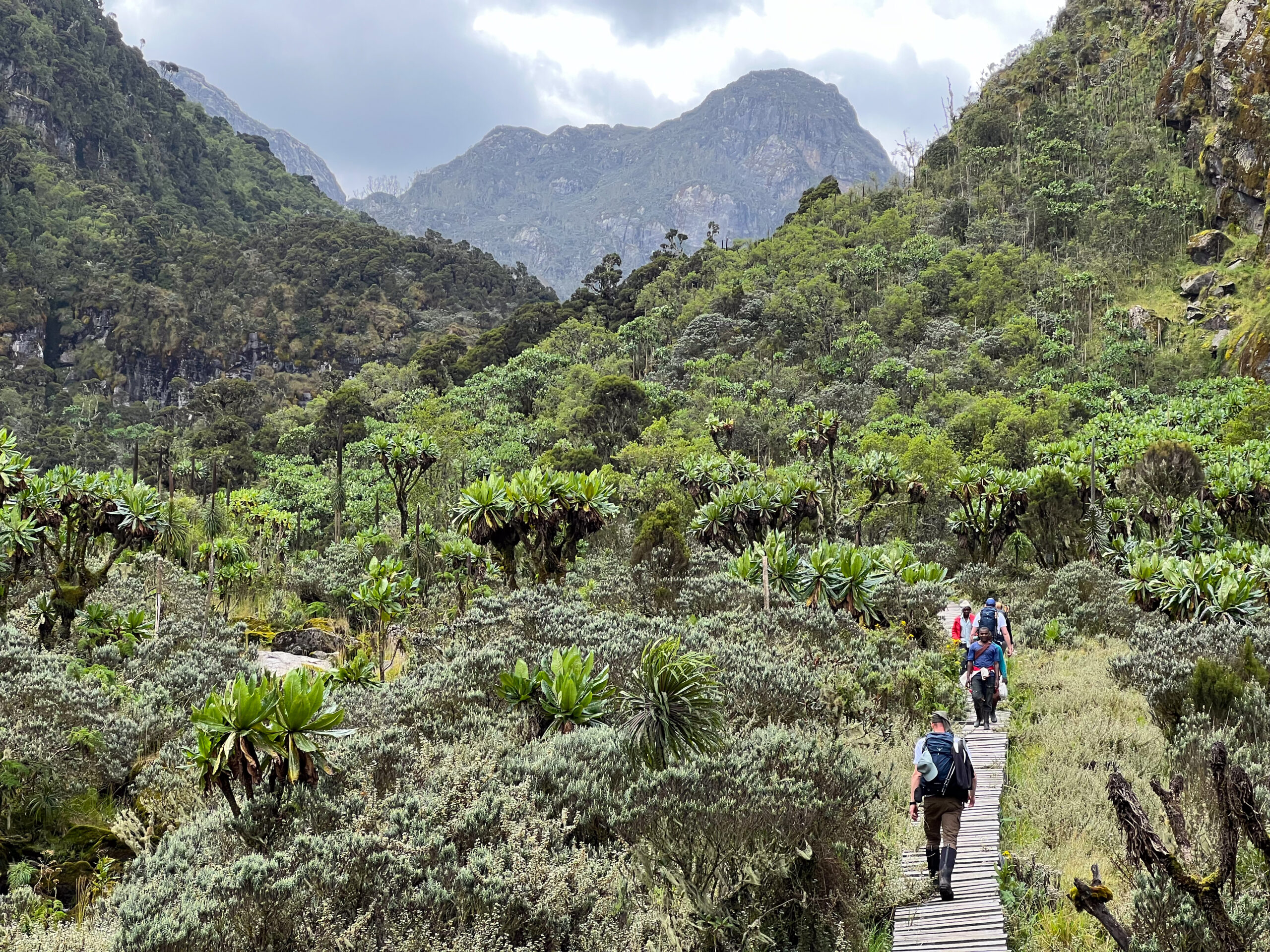
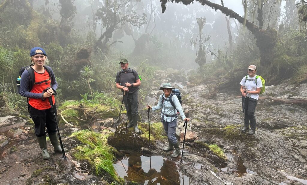
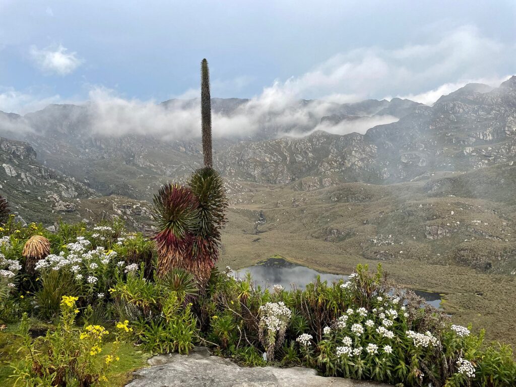
Day 3 is the heart of the 5-day Rwenzori hike to Bujuku and is one of the most visually extraordinary days of any mountain trek in Africa. After breakfast at 7:00 AM, the trail leaves John Matte Hut and drops briefly into the valley floor before entering the Lower Bigo Bog. What you see here is unlike anything in Kenya, Tanzania, or Ethiopia. The valley floor at 3,600–3,900m is a vast peat bog accumulated over thousands of years, carpeted in spongy cushion plants, and dotted with some of the most remarkable plant life on Earth.
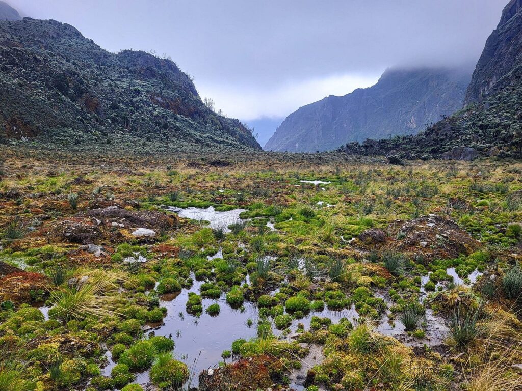
Giant lobelias (Lobelia wollastonii), the Rwenzori’s most iconic plant, stand 4–5 metres tall, their silver-green rosettes glistening with captured moisture. Giant groundsels (Senecio adnivalis) with their thick, felted leaves and yellow flowers form small trees across the open ground. Everlasting flowers (Helichrysum stuhlmannii) carpet the spaces between them. Long wooden boardwalks, some sections spanning 100 metres or more, carry you above the bog surface, allowing you to walk through this prehistoric-looking landscape without sinking. Read more about the Rwenzori vegetation zones to understand what you are seeing and why it only exists here.
Upper Bigo Bog and Lake Bujuku
Past the Lower Bigo Bog, the trail crosses a wooden bridge and climbs through the Upper Bigo Bog, where the same surreal Afro-alpine vegetation continues at higher density. The sky often sits low here; clouds roll in from the west over the Stanley massif, and the bog can be misty and dramatic in ways that make every photograph feel like something from another era. Ravens and alpine chats are the most common birds; the silence between their calls is total.
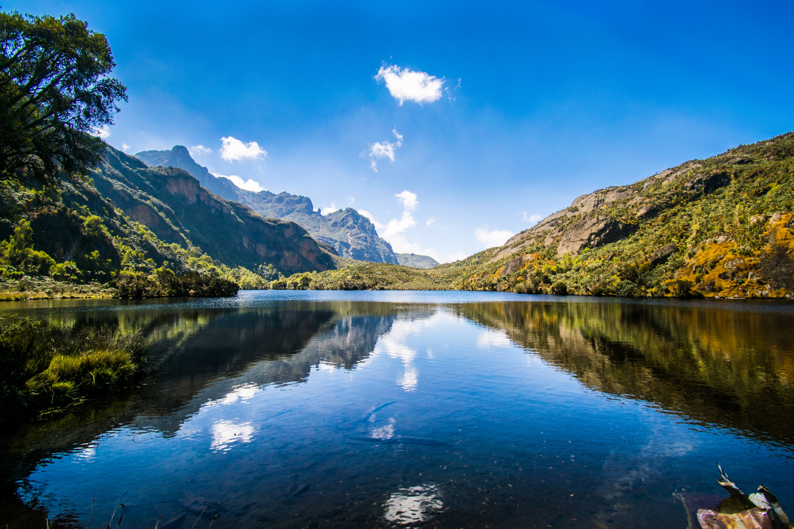
Descending from the Upper Bigo, the trail reaches Lake Bujuku, a glacially carved tarn sitting at approximately 3,960 m, its dark water reflecting the peaks surrounding it on three sides. This is a genuine wilderness moment. Sit at the lake edge and look: to the west, the rock flanks of Mount Stanley (5,109 m) rise almost vertically, a glacier visible as a bright band above the rock. To the north, Mount Speke (4,890 m) towers into the clouds. To the south, Mount Baker (4,843m) completes the horseshoe. You are standing inside the Rwenzori’s innermost chamber, the valley that every summit route passes through and which most trekkers see only as a transit point.
Arrival at Bujuku Hut
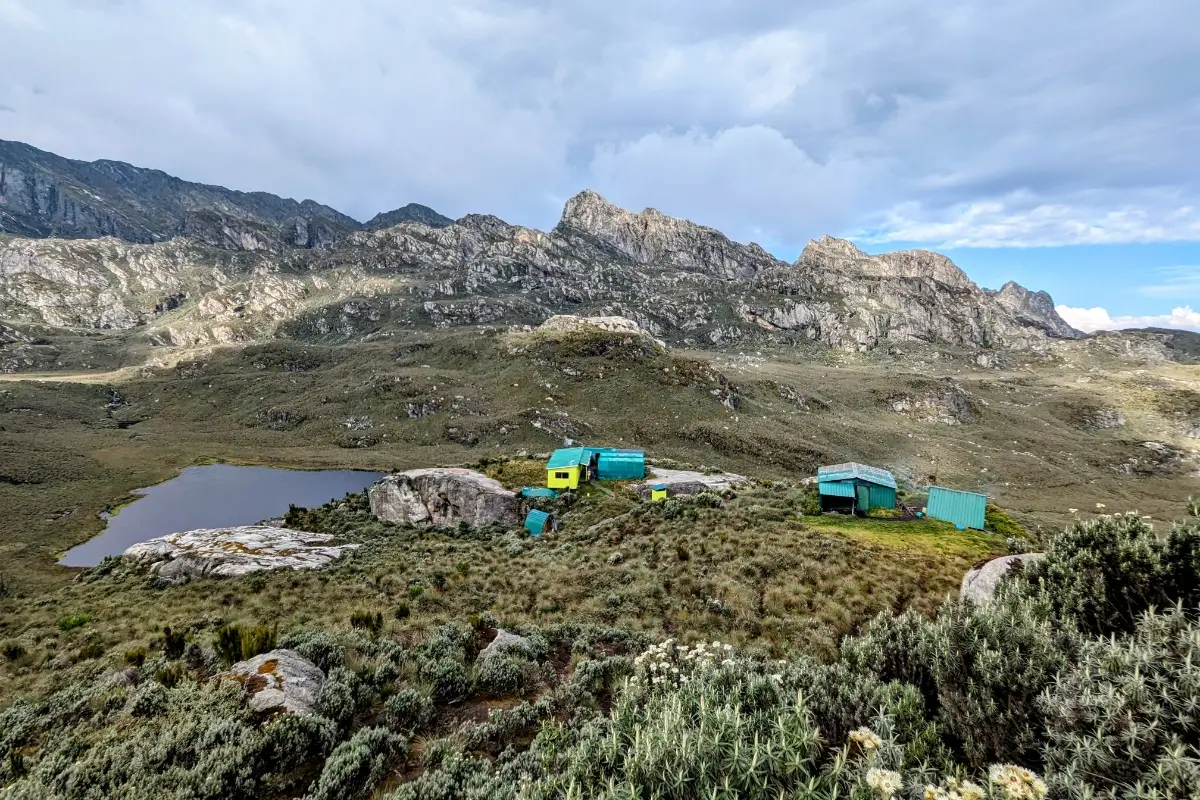
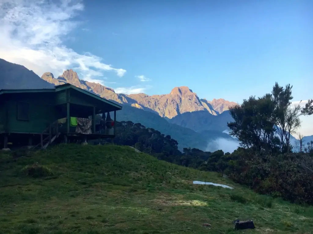
Bujuku Hut is 10–15 minutes beyond the lake shore, perched above the valley floor at 3,977 m. This is your overnight camp for Day 3, the highest point of the entire 5-day Bujuku hike, and it is as dramatic a mountain camp as you will find anywhere in East Africa. The hut sleeps 16 in wooden bunks, with a kitchen and dining space separate from the sleeping quarters. After the short day’s hiking, you have time in the afternoon to explore the lake shore, sit with the views, and truly inhabit this landscape.
Night temperatures at Bujuku can drop to between 0°C and -2°C. Your guide will recommend extra layers at dinner. The mountain is often quiet by 9:00 PM, and even if sleep is briefly interrupted by altitude (common above 3,800 m), waking in the small hours to find the mist cleared and the glacier-lit peaks visible above the hut is, for most trekkers, one of the defining memories of the trip.
Day 3 Highlights
- The Bigo Bog boardwalks the most photographed section of the Central Circuit
- Giant lobelias and groundsels: Afro-alpine vegetation at its most surreal
- Lake Bujuku a glacial tarn at 3,960 m surrounded by three great peaks
- The Rwenzori triangle: Stanley, Speke, and Baker visible together from Bujuku Hut
- Arrival at Bujuku Hut (3,977 m), the deepest point of the trek
DAY 4: BUJUKU HUT → NYABITABA HUT (3,977 m → 2,652 m) | ~19 km
Hiking time: 7–9 hours | Elevation loss: −1,325 m | Overnight: Nyabitaba Hut (2,652 m)
Descent Through the Alpine Moorland
Day 4 is the long descent, a full day back through the terrain you climbed over Days 2 and 3, which now looks entirely different from the other direction, in different light, and with your eye now trained to see what it missed on the way up. Depart after breakfast at 7:00 AM. The first section reverses the Lake Bujuku shoreline and re-enters the Upper Bigo Bog.
Descending through the boardwalks with the peaks still visible behind you is a particularly fine moment. The giant lobelias that were backlit by morning clouds on Day 3 are now forward-lit by the afternoon sun. Groundsels that seemed alien on the way up feel familiar now that you know their names. You have spent a night at 3,977m and earned the right to call this place something more than a view.
Back Through John Matte and the Forest
A rest stop at John Matte Hut (3,414 m), your Day 2 overnight camp for packed lunch and hot drinks. Then the trail drops steeply back into the heather zone and, below it, the bamboo forest. The descent from John Matte to Nyabitaba (2,652 m) takes 3–4 hours on a well-worn but slippery trail when wet. Trekking poles are essential on the way down; the rooted, muddy sections that were particularly challenging on the ascent are harder still on weary descending legs.
The Kurt Schafer Bridge reappears; the sound of the Bujuku and Mubuku rivers below is louder or quieter depending on overnight rainfall. Cross back through the forest, and the final push up to Nyabitaba Hut arrives in the late afternoon. Your mountain cook has dinner ready by 7:00 PM. This is the last night on the mountain, and many trekkers spend time after dinner with their guides, sharing tea and asking the questions they didn’t know to ask at the beginning of the trek about the mountains, the Bakonzo, and the glaciers retreating above. It is often the most captivating conversation of the trip.
Day 4 Highlights
- Final morning views of the Rwenzori triangle from the Bujuku Valley
- The Bigo Bog in a different light: a familiar landscape seen anew
- Long descent through the bamboo and forest zones
- Second crossing of the Kurt Schafer Bridge
Final overnight at Nyabitaba Hut (2,652 m)
DAY 5: NYABITABA HUT → NYAKALENGIJA (2,652 m → 1,600 m) | ~8 km
Hiking time: 3–4 hours | Elevation loss: −1,052m | End of trek
The Final Descent to the Trailhead
After a relaxed breakfast, the final descent to Nyakalengija takes 3–4 hours. The trail drops directly through the montane forest. Colobus monkeys often reappear on this final day, as if to bid you farewell, and then back through the Bakonzo farmland to the trailhead. On this last stretch, the Rwenzori peaks are briefly visible above the forest as the trail opens into the upper agricultural zone. It is worth pausing to look back.

At the UWA trailhead office in Nyakalengija, you formally conclude your trek. This is the moment for photographs with your guides and porters, for tipping (see our porter and guide tipping guide), and for the cold drink that has been on your mind since Bujuku. Transfer to accommodation in Kasese, or onward to Fort Portal, Kampala, or your next destination. The mountain stays with you.
Day 5 Highlights
- Final forest descent with colobus monkey sightings
- Last views of the high peaks above the Bakonzo farmland
- Farewell ceremony with your mountain team at Nyakalengija
Transfer to Kasese or onward destinations
Elevation Profile: 5-Day Rwenzori Hike to Bujuku
The elevation arc of this 5-day Rwenzori hike is steady, well-paced, and genuinely manageable for a fit trekker without high-altitude experience. Starting at Nyakalengija (1,600 m) on Day 1, you gain 1,052 m to reach Nyabitaba Hut (2,652 m), a generous gain that nonetheless leaves enough time in the afternoon to rest and acclimatize. Day 2 adds 762 m from Nyabitaba to John Matte Hut (3,414 m), passing through the bamboo zone and upper heather. Day 3 is the shortest day in distance but the most rewarding in scenery, with a 563 m gain from John Matte to Bujuku Hut (3,977 m), crossing the Bigo Bog and arriving at Lake Bujuku.
The return journey mirrors the ascent. Day 4 is the longest day in kilometers (approximately 19 km), descending 1,325 m from Bujuku back to Nyabitaba. Day 5 is the gentle 8 km descent to the trailhead, losing the final 1,052 m. Total ascent across the 5 days: approximately 2,377 m. Total descent: approximately 2,377 m. No glacier travel, no technical sections, and no altitude above 4,000 m, which means the acclimatization risk is significantly lower than on any Margherita Peak summit route.
| Day 1 Start | Nyakalengija: 1,600 m |
| Day 1 End | Nyabitaba Hut: 2,652 m (+1,052 m) |
| Day 2 End | John Matte Hut: 3,414 m (+762 m) |
| Day 3 High | Bujuku Hut: 3,977 m (+563 m) highest point of trek |
| Day 4 End | Nyabitaba Hut: 2,652 m (−1,325 m from Bujuku) |
| Day 5 End | Nyakalengija: 1,600 m (−1,052 m) |
| Total Ascent | ~2,377 m |
| Total Descent | ~2,377 m |
| Max Elevation | 3,977 m (below the 4,000m altitude-risk threshold) |
Mountain Huts & Camps on the 5-Day Bujuku Route.
Nyabitaba Hut, 2,652 m (Day 1 & Day 4 Overnight)
Nyabitaba Hut is the first and last mountain overnight on this itinerary; you sleep here only once. Located at 2,652 m on a forested ridge with views south over the Mubuku River valley, it is one of the most comfortable huts on the Central Circuit. The hut sleeps 16–20 trekkers in bunk-style sleeping platforms, with a separate kitchen shelter and composting toilet. Evenings at Nyabitaba are warm enough to sit outside; temperatures sit around 10–14°C. It’s common to see sunbirds feeding in the heathery vegetation around the hut at dusk. The Kurt Schafer Bridge is a 25-minute walk downhill. The Portal Peaks’ two dramatic rocky summits, visible from the ridge, frame the evening sky.
John Matte Hut, 3,414 m (Day 2 Overnight)
Named after a legendary Rwenzori mountain guide whose family has worked these trails for generations, John Matte Hut sits at 3,414 m in a broad grassy clearing marking the transition between upper montane forest and the first true alpine zone. The hut sleeps 16 on tiered wooden bunks in a single sleeping shelter, with a separate kitchen and dining area. On clear evenings, the first views of the high-altitude massifs appear over the valley ahead, Mount Stanley’s snow line sometimes catching the last of the sunset light. Night temperatures here drop to 5–8°C; a sleeping bag rated to 0°C is comfortable. There is a single composting toilet and a stream nearby for washing.
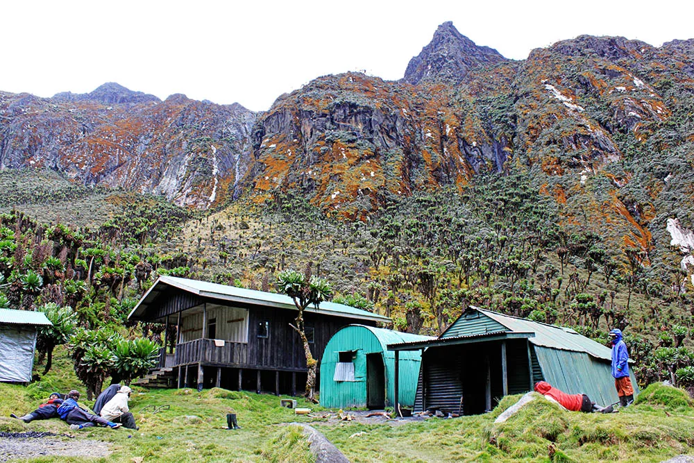
Bujuku Hut, 3,977 m (Day 3 Overnight)
Bujuku Hut is the centerpiece of the entire 5-day hike, the deepest camp, the most dramatic viewpoint, and the most memorable night. The hut sits at 3,977m in the upper Bujuku Valley, surrounded on three sides by the massifs of Mount Stanley, Mount Speke, and Mount Baker. Lake Bujuku, a glacially carved tarn, shimmers 15 minutes below the hut. The sleeping space accommodates 16–20 in wooden bunks. Night temperatures can reach 0°C to -2°C; a proper cold-weather sleeping bag is essential. Trekkers who wake in the small hours on a clear night often report seeing the Stanley Glacier reflecting moonlight above the hut, one of those rare mountain experiences that stays with you for life.
Flora & Wildlife: What You’ll Encounter on the Bujuku Trek.
The Rwenzori Mountains are UNESCO-listed partly because their ecological range is extraordinary: five distinct vegetation zones stacked within a 2,400m vertical band. This 5-day hike to Bujuku traverses all of the areas below the glacial nival zone, making it one of the most botanically rich short treks in Africa.
Montane Forest Zone (1,600–2,500m) Days 1 & 5
Uganda’s mountain rainforest is rich, layered, and alive. The Rwenzori wildlife guide details the full species list, but on Day 1 you are most likely to encounter black-and-white colobus monkeys (Colobus guereza) in the upper canopy. L’Hoest’s monkeys are found in mixed-canopy groups, along with Rwenzori turacos (Tauraco johnstoni), which are endemic to the mountain and known for their crimson wing flash; white-starred robins; Rwenzori batis; and Hartlaub’s ducks, which are often seen near streams. Three-horned chameleons (Trioceros johnstoni) are regularly spotted on branches in the lower forest and bamboo zone, one of the most thrilling endemic wildlife encounters in Uganda.
Bamboo Zone (2,200–2,800m) Day 2
Mountain bamboo (Arundinaria alpina) forms a dense corridor above the mixed forest. Light filters green through tall culms; the understory is rich in mosses, ferns, and orchids. Bamboo zones in East Africa are transitional environments with their own specialized species. L’Hoest’s monkeys frequently use them as movement corridors, and chameleons are particularly common in the lower bamboo.
Heather Zone (2,800–3,500m) Days 2 & 4
Above the bamboo, tree heather (Erica arborea and Erica trimera) forms an increasingly gnarled and sculptural woodland, draped in pale green Usnea lichen (‘old man’s beard’). The visual texture of lichen-covered heather in morning mist is one of the Rwenzori’s most distinctive and photographed landscapes. This zone hosts common ravens, sunbirds, and the endemic Rwenzori nightjar.
Afro-Alpine Moorland (3,500–4,000m) Days 3 & 4
The Rwenzori’s most globally famous ecological zones, the Bigo Bog and upper Bujuku Valley floor, are dominated by three iconic plant groups: giant lobelias (Lobelia wollastonii and Lobelia bequaertii), which grow 4–5 m tall; giant groundsels (Senecio adnivalis and Senecio erici-rosenii), which form dense stands of tree-like plants with felted leaves; and everlasting flowers (Helichrysum stuhlmannii and related species), which cover the ground in silver and gold. This area is the landscape that makes the Rwenzori so recognizable in nature photography. Read the full vegetation zone guide for a complete botanical breakdown.
Bird life in the Afro-alpine zone is reduced but memorable: common ravens, alpine chats, and Rwenzori double-collared sunbirds are frequently seen at the hut edges and bog margins. On clear mornings, raptors, including augur buzzards, circle above the valley.
Physical Difficulty & Fitness Requirements
The 5-day Rwenzori hike to Bujuku sits at the upper end of the moderate range and should not be underestimated. It does not require technical mountaineering skills or glacier experience, but it is a genuine multi-day mountain trek through challenging terrain. Read our full Rwenzori trekking difficulty guide for an in-depth breakdown.
Who This Trek Is Suited For
- Fit hikers who regularly walk 15–20km with a daypack
- Trekkers with some multi-day hiking experience (not necessarily at altitude)
- Anyone who can sustain 5–8 hours of mountain hiking on consecutive days
- Beginners to alpine environments who want a structured, guided introduction
- Older trekkers who are fit and healthy see our guide for trekkers over 50 and 60
- First-timers to the Rwenzori should see our beginners’ guide
Key Physical Challenges
- Day 2 is the hardest hiking day: 12km with 762m of elevation gain, some of it steep
- Day 4 is the longest day: approximately 19km of descent on a root-bound, sometimes muddy trail
- Wet terrain: constant rubber boots and waterproof clothing are non-negotiable
- The trail is uneven throughout; loose roots, mud, rocks, and river crossings are standard
- Night temperatures at Bujuku Hut can reach 0°C; proper sleeping gear is essential
Altitude Considerations
The maximum elevation on this trek is 3,977m at Bujuku Hut. This is below the 4,000m threshold where serious altitude-related illness becomes more common, but it is high enough for mild altitude symptoms to appear, particularly mild headache, reduced appetite, and slightly disrupted sleep at Bujuku. These are normal and manageable.
The critical rules for safe altitude management on this trek: walk at the guide’s pace, drink a minimum of 3 liters of water daily, eat full meals even when appetite is reduced, and report any worsening symptoms to your guide immediately. Unlike the summit routes, this trek does not enter the danger zone, but the same acclimatization principles apply and should be respected. If you have a history of serious altitude sickness, consult your doctor before booking.
Training Recommendations
In the 8–12 weeks before your trek, prioritize long hiking days (15–20 km with 500–700 m elevation gain), stair or hill repeats for knee and ankle conditioning, and at least one overnight multi-day hike to get used to sleeping in mountain conditions. Full training guidance is in our Rwenzori fitness and training guide.
Best Time to Do the 5-Day Rwenzori Hike to Bujuku
The Rwenzori Mountains receive precipitation every month, making them one of the wettest mountain ranges on Earth and ecologically extraordinary. ‘Good weather’ is relative here; the question is not ‘will it rain?’ but ‘how much, and when?’ See our full guide to the best time to visit the Rwenzori for a month-by-month breakdown.
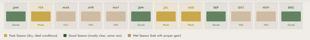
Primary Dry Window: January–February
January and February are the Rwenzori’s most reliable dry months. Mist is less persistent, trails are firmer, and the chances of clear views at Bujuku Hut, with the Rwenzori triangle fully visible, are highest. This is the peak recommended season for the Bujuku trek.
Secondary Dry Window: June–August
The June–August window is the second most reliable period. Conditions are generally drier than the wet season, though mist and cloud are still common in the afternoons. The Bujuku Valley tends to clear to blue skies in the early mornings, which is when the views are most dramatic. June–August also coincides with the European summer holiday period, making it the busiest season on the mountain.
Wet Season: March–May and October–December
The Rwenzori’s wet seasons deliver heavier rainfall and more persistent mist. Trails become significantly muddier, and the bog sections on Day 3 are wetter and more difficult. That said, the wet season has its own beauty: the vegetation is at its most lush, the waterfalls are powerful, and the mountain has a brooding atmosphere that experienced trekkers often find more compelling than the clear-season version. Proper waterproof gear and mental preparedness make the wet season entirely viable on this non-summit route.
💡 This trek is possible year-round with the right gear. Do not let the wet season deter you; talk to our guides about what to expect in any given month before deciding.
What’s Included in the 5-Day Bujuku Trek Package.
Included
- All Uganda Wildlife Authority (UWA) park entry fees and hut fees
- Professional certified mountain guide (English-speaking, Central Circuit specialist)
- Assistant guide for groups of 4 or more
- Mountain chef and full catering: all meals from Day 1 lunch to Day 5 breakfast
- One porter per trekker (carrying up to 15kg of your pack and communal gear)
- Accommodation in mountain huts: Nyabitaba (Days 1 & 4), John Matte (Day 2), Bujuku (Day 3)
- Free loan of rubber boots (gumboots) for the lower mountain sections
- Sleeping mats in all huts
- First aid kit and emergency communication equipment carried at all times
- Porter wages, meals, and accommodation during the trek
Not Included
- International flights and Uganda visa fees
- Pre- or post-trek hotel accommodation in Kasese or Fort Portal
- Airport or hotel transfers (can be arranged; ask us)
- Travel insurance (strongly recommended, see below)
- Tips for guides and porters (see tipping guide for recommended amounts)
- Personal trekking clothing, boots, and sleeping bag
- Bottled water, soft drinks, beer, or alcohol
- Any costs from itinerary changes due to weather, illness, or force majeure
📋 Note: This trek does not include glacier or technical climbing equipment no crampons, harnesses, ropes, or ice axes are used. This is a trekking route only.
Full Packing & Gear List: 5-Day Rwenzori Hike to Bujuku
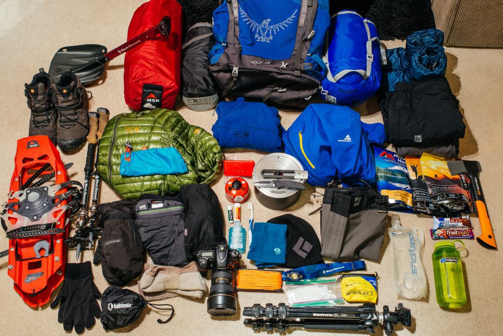
The Rwenzori Mountains are permanently wet. This is not a seasonal characteristic; it is a defining environmental condition. The difference between a wonderful trek and a miserable one on this trail depends almost entirely on how well your gear can handle sustained moisture. Study our full Rwenzori packing list before departure, and read the boot and footwear guide carefully. Footwear selection is the single most important gear decision for this trek.
Clothing
- Moisture-wicking thermal base layer (top and bottom): minimum 2 sets
- Mid-layer fleece or lightweight down jacket
- Insulated jacket (down or synthetic) essential for evenings at Bujuku (0°C possible)
- Waterproof shell jacket (Gore-Tex or equivalent) this is mandatory, not optional
- Waterproof shell trousers
- Gaiters (knee-length) to keep mud and water out of boots
- 2 pairs of trekking trousers (quick-drying synthetic)
- Warm beanie and a sun hat
- Light gloves and one pair of warmer gloves for Bujuku night
- 4+ pairs of wool or synthetic trekking socks
Footwear
Rubber gumboots (Bogs, Dunlop, or equivalent) are provided free of charge and are standard for the lower forest and bog sections. You will also need waterproof hiking boots for the upper rocky sections and the approach to Bujuku. Read the complete footwear guide for exact specifications. No crampons or technical footwear is needed on this non-summit route.
Equipment
- Trekking poles two, telescopic, strong (used constantly on this trail)
- Headlamp with fresh batteries and at least one spare set
- Sleeping bag rated to 0°C or below (comfort rating, not limit rating)
- Sleeping bag liner for additional warmth at Bujuku
- Waterproof dry bags to protect electronics and clothing inside your pack
- Main pack (40–50 L) for porter-carried items
- Daypack (20–25L) for personal items on the trail each day
- Water bottles or hydration bladders with a minimum 2-liter capacity
- Water purification tablets as backup (streams are clean but caution is wise)
- Sunglasses (UV protection for high-altitude exposure)
- High-SPF sun cream
Health & Personal Items
- Personal prescription medications
- Basic first aid: ibuprofen, paracetamol, blister plasters, antiseptic cream, rehydration salts
- Foot care: moleskin, blister prevention balm (constant moisture = blister risk)
- High-energy snacks: energy bars, nuts, chocolate, dried fruit for trail days
- Electrolyte sachets (critical for hydration management at altitude)
- Camera and power banks (no charging on mountain)
- Quick-dry travel towel
- Biodegradable soap and personal hygiene items
- Small amount of cash (USD) for tipping at trek end
Permits, Park Fees & Cost Breakdown
The Uganda Wildlife Authority (UWA) regulates all trekking in Rwenzori Mountains National Park. All permits, hut fees, and guide fees are mandatory and must be arranged through a licensed operator. Our full Rwenzori cost breakdown for 2026 provides detailed fee schedules for all routes and group sizes.
| UWA Park Entry | USD $40 per person per day (5 days = USD $200 total, included in package) |
| UWA Hut Fees | Included in our package price |
| Professional Guide | Included certified UWA and Central Circuit guide |
| Porters | Included one per trekker at standard rates |
| All Mountain Meals | Included: Day 1 lunch through Day 5 breakfast |
| Rubber Boot Loan | Included free of charge |
| Sleeping Mats | Included in all mountain huts |
| Technical Gear | NOT applicable; no glacier equipment required on this route |
| Gratuities | NOT included; see our tipping guide for recommended amounts |
| Pre/Post Hotel | NOT included; arrange separately in Kasese or Fort Portal |
Contact us for the current per-person price for the 5-day Bujuku trek. Prices vary by group size and season. For comparison, the 4-Day Rwenzori Mutinda Lookout trek (Kilembe Trail) is available from USD $645 per person. The 7-day Margherita Peak climb starts at USD $1,400 per person.
Getting to the Rwenzori Trailhead
The trailhead for the 5-day Rwenzori hike to Bujuku is Nyakalengija, approximately 13km from Kasese town in Western Uganda. Our guide to getting to the Rwenzori Mountains details full logistics.
From Kampala (approximately 5–6 hours)
Daily bus services depart from Kampala’s Kisenyi bus park to Kasese. Journey time is 5–6 hours. Companies including Link Bus and Gateway Bus serve this route. We offer private vehicle transfers at your preferred departure time, which we recommend for groups or trekkers with specific schedules.
From Entebbe International Airport
Most international arrivals land at Entebbe (EBB), 40km from Kampala. The total road journey from Entebbe to Kasese is 5.5–6.5 hours. Charter flight options to Kasese Airport (KSE) exist for groups willing to reduce travel time. Ask us about current availability.
Pre-Trek Accommodation in Kasese
We strongly recommend arriving in Kasese the evening before your trek departure. Our Kasese travel guide for trekkers lists the best hotels and guesthouses near the trailhead. For post-trek recovery, Fort Portal (40km north) offers excellent lodges and is an ideal base for a rest day before continuing your Uganda itinerary. We can arrange hotel bookings on request.
Book Your Trek
Respond within Minutes
From
$1,000
per person
- Duration 5 Days / 4 Nights
- Group Size 1–15 people
- Start Point Nyakalengija
- Departures Year-round
- No Summits Bujuku Valley
No booking fee. Free cancellation up to 30 days before departure. We respond within Minutes.
Explore More Rwenzori Trekking Itineraries
Not sure if the 5-day Bujuku trek is the right fit. Here are the most closely related options:
3-Day Mahoma Loop Hike
$700 Per Person
A shorter non-summit loop through the forest and lakes below the Bujuku approach
A shorter non-summit loop through the forest and lakes below the Bujuku approach
6-Day Margherita Peak Climb
$1,400 Per Person
The ideal summit route for fit, experienced trekkers.
The ideal summit route for fit, experienced trekkers.
Short Magherita Hike (5-Day Central Circuit)
$1400 Per Person
Add the summit to your 5-day schedule with one extra push
Add the summit to your 5-day schedule with one extra push
Rwenzori Hike (7 Days Central Circuit)
$1400 Per Person
The best all-round Rwenzori summit itinerary with optimal acclimatisation
The best all-round Rwenzori summit itinerary with optimal acclimatisation
Frequently Asked Questions: 5-Day Rwenzori Hike to Bujuku.
What is the 5-day Rwenzori hike to Bujuku and who is it for?
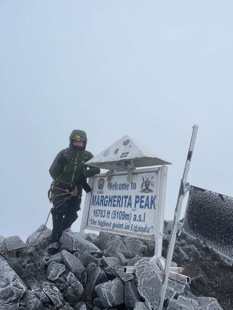
The 5-day Rwenzori hike to Bujuku is a guided trekking itinerary that takes you deep into Rwenzori Mountains National Park via the Central Circuit Trail, reaching Bujuku Hut (3,977 m) at the heart of the mountain’s most spectacular alpine valley. Unlike the summit routes that continue to Margherita Peak (5,109 m), this trek stops at Bujuku, putting you at the closest possible viewpoint to three of Africa’s great peaks (Mount Stanley, Speke, and Baker) without any technical glacier climbing. It is ideal for fit trekkers who want an authentic, deep-mountain experience without the technical demands of a summit attempt.
Do I need any mountaineering or technical climbing experience for the 5-day Bujuku trek?
No technical climbing experience is required for the 5-day Rwenzori hike to Bujuku. There is no glacier travel, no rope work, no crampons, and no fixed rope sections on this route. What you do need is solid multi-day hiking fitness, comfort in wet and muddy terrain, and the ability to sustain 5–8 hours of mountain walking on consecutive days. The trail is steep in sections, particularly on Day 2 and the descent on Day 4, but it is a walking route throughout. First-time high-altitude trekkers who are physically fit can comfortably complete this itinerary.
How difficult is the 5-day hike to Bujuku compared to longer Rwenzori summit routes?
The 5-day Bujuku trek is significantly less demanding than any Margherita Peak summit route. The key differences are: no technical glacier climbing, maximum elevation capped at 3,977 m (rather than 5,109 m), no pre-dawn start required, and no specialist equipment such as crampons or harnesses. Day 2 (Nyabitaba to John Matte, 12 km, +762 m) is the hardest hiking day, and Day 4 (19 km descent from Bujuku to Nyabitaba) is the most physically taxing in terms of distance. Overall, this is a challenging but accessible multi-day mountain trek rated moderate-to-hard rather than expert-only.
Will I see anything impressive without summiting? Is the Bujuku Valley worth it?
Absolutely, and we would argue this without hesitation. The Bujuku Valley is the Rwenzori’s innermost chamber, the point where Mount Stanley, Mount Speke, and Mount Baker converge around you at 3,977 m. Glaciers are visible on all three massifs. Lake Bujuku shimmers on the valley floor. The Bigo Bog on Day 3 with giant lobelias 4–5 metres tall and prehistoric-looking groundsel trees is one of the most extraordinary walking environments anywhere in Africa. Many experienced trekkers who have done both the Bujuku trek and the summit route say the valley itself was more memorable than the glacier crossing. You do not need a summit to experience the Rwenzori at its most profound.
Is there any altitude risk on the 5-day Bujuku hike?
The maximum elevation on this trek is 3,977 m at Bujuku Hut, just below the 4,000 m threshold where more serious altitude illness becomes increasingly common. Most trekkers experience mild altitude symptoms at Bujuku: a slight headache, reduced appetite, and occasionally disrupted sleep. These are normal acclimatization responses. The risk of serious Acute Mountain Sickness (AMS), High-Altitude Cerebral Edema (HACE), or High-Altitude Pulmonary Edema (HAPE) is significantly lower on this route than on any summit itinerary. The key precautions are walk at the guide’s pace, drink 3–4 liters of water daily, eat full meals regardless of appetite, and report worsening symptoms immediately. Trekkers with a history of serious altitude illness should consult their doctor before booking.
What is Bujuku Hut: like facilities, sleeping conditions, and what to expect?
Bujuku Hut sits at 3,977 m in the upper Bujuku Valley adjacent to Lake Bujuku. It is a sturdy wooden mountain hut sleeping 16–20 trekkers in bunk-style platforms. There is a separate kitchen and dining shelter where your mountain cook prepares hot meals. Composting toilets are available. There is no electricity, no phone signal, and no charging facilities. Night temperatures can drop to 0°C or below, so a sleeping bag rated to 0°C (comfort rating) is essential, as is a sleeping bag liner for additional warmth. The hut is basic by lodge standards but perfectly functional and well-maintained. The setting surrounded by three of Africa’s towering peaks makes it one of the most memorable overnight stops of any Uganda trek.
What is the Bigo Bog and what makes it so special on the Rwenzori trek?
The Bigo Bog is a high-altitude peat bog at approximately 3,600–3,900m in the Bujuku Valley, traversed on Day 3 of this trek via long wooden boardwalks. It is one of the most ecologically unique environments in East Africa, carpeted in ancient peat moss and dominated by two of the Rwenzori’s most iconic plant groups: giant lobelias (Lobelia wollastonii) reaching 4–5 metres in height and giant groundsels (Senecio adnivalis) forming tree-like stands across the open bog. These plants are Afro-alpine species found nowhere else in Africa and are among the slowest-growing plants on Earth; some giant lobelias take decades to flower. Walking through the Bigo Bog feels genuinely prehistoric, and it is the section of this trek most frequently described by trekkers as a highlight they had not expected.
Can beginners or first-time mountain trekkers do the 5-day Bujuku hike?
Yes, the 5-day Rwenzori hike to Bujuku is one of the most appropriate entry points for first-time mountain trekkers who want a genuine Rwenzori experience. It does not require prior altitude experience, technical skills, or specialized equipment. What it does require is a solid fitness base, specifically the ability to hike 8–12 km with a pack on consecutive days and comfort in wet and uneven mountain terrain. Our beginners’ guide to climbing the Rwenzori covers exactly who is and is not ready for this trek. If you have been regularly hiking for 6+ months and can manage a 15km day with 500m elevation gain, you are a candidate for this route.
What is the best month to do the 5-day Rwenzori hike to Bujuku for good views?
The best months for clear views at Bujuku Hut are January–February (the primary dry window) and June–August (the secondary dry window). During these periods, mist is less persistent, and the morning hours in the Bujuku Valley frequently deliver clear views of all three surrounding massifs. That said, even in the dry season, the Rwenzori creates its own cloud and mist; you may have one clear morning and one misty one at Bujuku, and this unpredictability is part of the mountain’s character. The wet season (March–May, October–December) has significantly more rain but is still trekable with proper gear and often delivers a dramatically moody atmosphere that many trekkers prefer.
Can I extend the 5-day Bujuku hike to include a Margherita Peak summit attempt?
Yes, and this is actually a natural progression that we regularly arrange for trekkers who want to go further. From Bujuku Hut (3,977 m), the route to Elena Hut (4,563m) and then the Margherita Peak summit (5,109 m) continues on the Central Circuit. Adding a summit attempt from the Bujuku base requires at minimum 2 extra days (one night at Elena Hut, one summit day, one descent day), making it effectively a 7-day itinerary. See our 7-day Margherita Peak climb page for the full itinerary. If you are on the mountain and feeling strong at Bujuku, speak to your guide we can often arrange permit extensions for groups who decide mid-trek to attempt the summit.
What should I do for accommodation before and after the 5-day Bujuku trek?
We recommend staying one night in Kasese before the trek to meet your guide team, complete equipment checks, and rest before the early start. Our Kasese travel guide for trekkers lists the best options near the trailhead. After the trek, Fort Portal (40 km north of Kasese) is an excellent recovery base with good lodges, restaurants, and proximity to other attractions, including Kibale Forest (chimpanzee trekking) and the Crater Lakes region. For trekkers combining the Rwenzori with a wider Uganda itinerary, including gorilla trekking at Bwindi, we can build a full safari and trekking package. Our 12-day Rwenzori and gorilla trekking package is the most popular combination.
How the 5-Day Bujuku Trek Compares to Other Rwenzori Options.
| Trek | 5-Day Bujuku | 7-Day Margherita | 4-Day Margherita | 3-Day Mahoma |
| Max Elevation | 3,977m | 5,109m | 5,109m | ~2,990m |
| Summit Required | No | Yes | Yes | No |
| Difficulty | Moderate-Hard | Moderate | Very Hard | Easy-Moderate |
| Technical Gear | None | Glacier kit | Glacier kit | None |
| Best For | Non-summit experience | Most trekkers | Experts only | Short walks |
For trekkers debating between the Bujuku trek and a summit route, the honest guidance is as follows: if you have never been above 3,000 m before and are unsure of how you will respond to altitude, the 5-day Bujuku hike is the perfect introduction to the Rwenzori. It delivers the full ecological and scenic experience with manageable risk. If you decide at Bujuku that you want more, the summit is still an option you can always return to. To compare all our trails side by side, refer to the Rwenzori trekking routes overview.
Ready to Hike into the Heart of the Mountains of the Moon?
The Bujuku Valley is waiting. Five days. Four nights. Three of Africa’s greatest peaks surround you at 3,977 m, no glacier required. This is the Rwenzori at its most accessible and its most extraordinary.
When You Contact Us, You Will:
✔ Speak directly with a guide who knows the Bujuku Valley by heart ✔ Get a transparent, itemised quote for your group and chosen dates ✔ Receive honest advice on whether this or another Rwenzori route suits you best ✔ Confirm your booking with a 30% deposit, the rest due before departure
📲 WhatsApp: +256 773 256 104 | 📧 rwenzoritrekkingsafaris@gmail.com