Complete guide to the 8-day Rwenzori Kilembe Trail trek to Margherita Peak. Day-by-day itinerary, camps, wildlife, gear list & FAQs. Expert-guided from USD 1,705.
8-Day Rwenzori Trekking via Kilembe Trail | Climb Margherita Peak (5,109 m)
Overview of the 8-Day Rwenzori Kilembe Trail Trek | Climb Margherita Peak (5,109 m, Uganda)
The Rwenzori’s most scenic summit route. The southern trail, which relatively few trekkers have walked, features waterfalls, glacial lakes, dramatic passes, and Africa’s third-highest peak.
Rwenzori Trekking Safaris offers an 8-day Rwenzori trek via the Kilembe Trail, which includes climbing Margherita Peak. Envision embarking on an unforgettable journey to Uganda’s enchanting Rwenzori Mountains, commonly referred to as the “Mountains of the Moon.” Dedicated hikers and mountain lovers can climb Margherita Peak (5,109 m), Africa’s third-highest peak, on the 8-day Kilembe Trail journey.
This 8-day Rwenzori Trek starts from Kasese and returns via the Kilembe Trail, which is only accessible through Rwenzori Trekking Safaris. The 7 nights spent in eco-friendly mountain camps and huts deep in the Rwenzori ranges provide an authentic alpine experience, distinguishing this itinerary from the longer 10-day luxury option departing from Kampala.
Hike through rich moorland, breathtaking glaciers, Afro-montane woods, and vast lobelia meadows, among many other plant communities. The Kilembe Trail is an excellent choice for anyone looking for a real challenge away from the throng, as well as a clean and less congested path.

Experience a wonderful high-altitude hiking excursion in one of Africa’s most magnificent natural areas. Its biodiversity and natural beauty are unmatched. This 8-day Rwenzori hike is ideal for both experienced climbers and those looking for a memorable African adventure.
In awe of the majestic Rwenzori Mountains, get ready for an unforgettable 8-day/7-night mountain trek. There will be many obstacles to overcome as you traverse some of the most breathtaking landscapes in Africa. Glaciers, verdant valleys, and a myriad of ecosystems call the “Mountains of the Moon” their home. The Rwenzori Mountains will reward you with a breathtaking view while you test your mental and physical limitations.
The Kilembe Trail, also known as the Southern Circuit, is the most scenic, diverse, and well-developed trail in the Rwenzori Mountains. Managed by Rwenzori Trekking Services (RTS), it offers a modern trekking experience with cleaner huts, better infrastructure, and a smoother ascent profile than the historic Central Circuit.
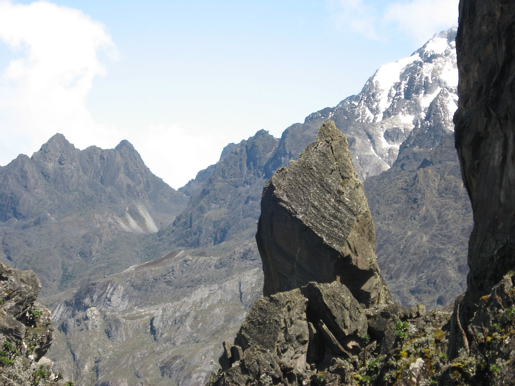
This trail begins in Kilembe, Kasese, on the foothills of the Rwenzori (1,450 m) and ascends through five distinct vegetation zones to reach the glaciated high peaks: Mt. Stanley, Mt. Baker, and Weismann Peak. Known for its stunning landscapes, crystal lakes, hanging valleys, dramatic bogs, rugged ridges, and snow-capped summits, the Kilembe Trail is widely regarded as the best route for reaching Margherita Peak (5,109 m).
8-Day Kilembe Trail Rwenzori Trek At-a-Glance
| Duration | 8 days / 7 nights on the mountain |
| Total Distance | Approximately 65 km (Kilembe trailhead loop) |
| Maximum Elevation | 5,109 m (Margherita Peak, Mount Stanley) |
| Lowest Point | 1,450 m (Kilembe trailhead, near Kasese) |
| Total Elevation Gain | Approximately 3,660 m cumulative ascent |
| Difficulty | Challenging physically demanding with glacier section on summit day |
| Trail | Kilembe Trail (Southern Circuit), Rwenzori Mountains National Park |
| Start / End Point | Kilembe, Kasese, western Uganda |
| Best Months | December to February; June to August |
| Group Size | Minimum 1; private and group departures available |
| Accommodation | Modern RTS mountain huts along the Kilembe Trail |
| Glacier Equipment | Crampons, ice axe, harness, helmet (provided on summit day) |
| Price | From USD 1,705 per person |
| Operator | Rwenzori Trekking Safaris |
Why Choose the 8-Day Kilembe Trail to Margherita Peak?
The Kilembe Trail, also known as the Southern Circuit, is the most scenically varied approach to Margherita Peak (5,109 m) in the Rwenzori Mountains. It begins in the old copper-mining village of Kilembe at 1,450 m, lower than any Central Circuit trailhead, and climbs through five ecological zones before reaching the glaciated upper mountain. The extra day compared to the 7-Day Central Circuit is used to perfection here: the Kilembe route simply has more to see, and the eight-day schedule gives you time to absorb it.
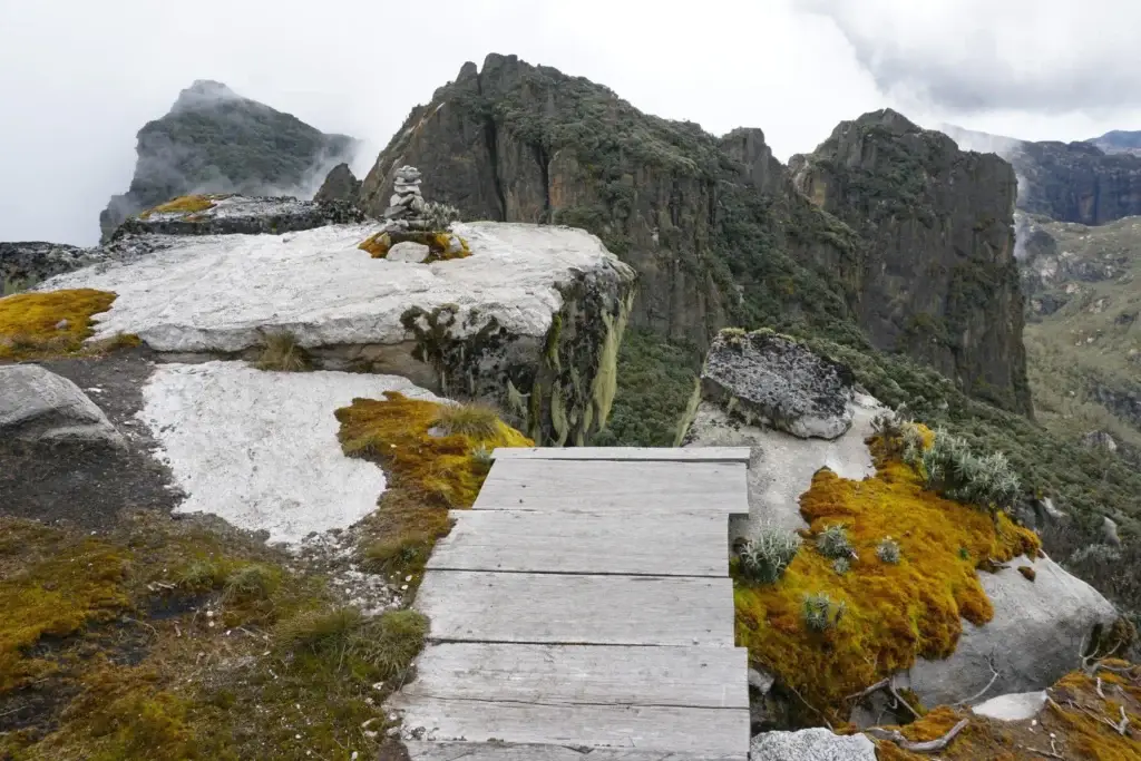
This trail stands out from the Central Circuit because of its combination of infrastructure quality and landscape drama. Managed by Rwenzori Trekking Services (RTS), the Kilembe huts are among the best-maintained on the range: cleaner, better equipped, and more structurally sound than some of the older Central Circuit shelters. The route itself passes named landmarks that do not exist on the northern approach: Enoch’s Falls near Sine Camp; the sweeping Mutinda Lookout at 3,975 m with panoramic views across Kasese and Lake George; the glacially carved hanging valleys above Bugata Camp; and the bird-rich Bamwanjara Pass where Malachite Sunbirds feed on lobelia flowers at 4,450 m.
The summit approach is also distinctive. Rather than ascending from Elena Hut on Mount Stanley’s rocky western shoulder, the Kilembe route positions you at Margherita Camp (4,485 m), sheltered between giant boulders below Scott-Elliot’s Pass. The 2:00 a.m. departure on summit day crosses the Stanley Plateau Glacier under headtorch before the Congo clouds roll in, and you descend via Oliver’s Pass and the Weismann Peak ridge on Day 7, an entirely different perspective on the upper mountain. If you want the Rwenzori’s full visual range, the Kilembe Trail delivers it. For a direct comparison of both options, see our Central Circuit vs Kilembe Trail guide.
The Rwenzori Mountains are a UNESCO World Heritage Site and host Africa’s last equatorial glaciers, currently retreating at a rate that scientists predict will eliminate them entirely before 2040. The Kilembe Trail passes directly beneath the zones where this retreat is most visible; the Bamwanjara Pass glacier views and the Stanley Plateau ice make the scale of this change viscerally real. Read the full context in our Rwenzori glacier retreat report.
Full Day-by-Day Itinerary: 8-Day Kilembe Trail Rwenzori Trek.
Day 1: Kilembe Trailhead (1,450 m) to Sine Camp (2,596 m) | ~8 km | 4-5 hours
Your expedition begins at the Rwenzori Trekking Services base camp near Kilembe, a small settlement best known as the site of Uganda’s former copper mines, nestled at the southwestern foot of the Rwenzori range. After a thorough briefing, equipment check, and porter assignment, you register at the Rwenzori Mountains National Park gate and enter the forest at 1,450 m.

The initial trail follows the valley floor through tall afro-montane forest. This lower belt is one of Uganda’s richest birding zones, and it sings in the morning. Blue monkeys and black-and-white colobus troops move through the canopy; groups of 15 to 20 colobuses are regularly seen on this section, their black and white coats flashing between the branches. Chimpanzees occasionally bark from the deeper forest. The air here is warm and humid, and the forest architecture towering hardwoods draped in epiphytic moss, bamboo thickets, and flowering vines makes this section feel far removed from any other trail in East Africa.
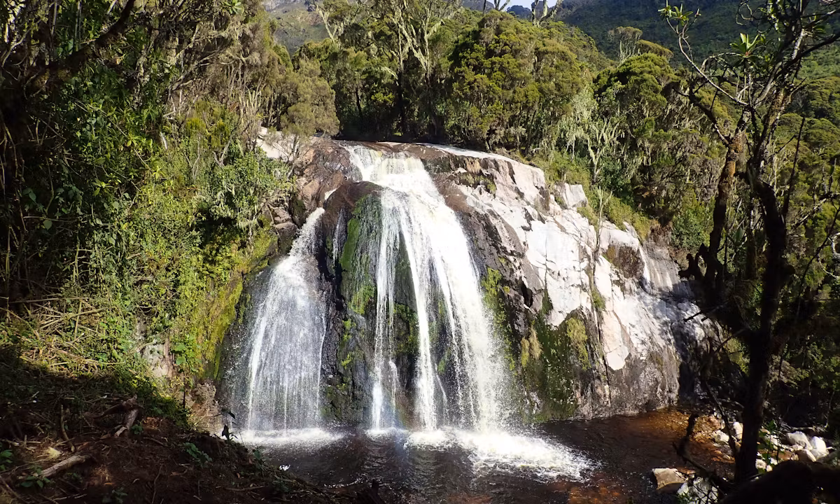
The day’s elevation gain of 1,146 m is the steepest single-day ascent on the itinerary, but the trail is well-cut and the pace gentle. Approximately 200 m from Sine Camp, the trail passes Enock’s Falls, a multi-tiered cascade dropping through moss-draped rock into a clear plunge pool. It is the first of many waterfalls on this route, and on a warm afternoon it provides one of the most compelling wild swimming opportunities in the entire park. Sine Camp sits at 2,596 m in the upper montane zone, a solid timber hut with views back down the valley toward Kasese.
Guide InsightIf you are in excellent physical condition, you may push to Kalalama Camp (3,134 m) on Day 1. This gains you additional time at Mutinda Camp for the Mutinda Lookout acclimatization hike on Day 2. Elevation gain today: approximately 1,146 m. Sleep elevation: 2,596 m (or 3,134 m if extending). |
Day 2: Sine Camp (2,596 m) to Mutinda Camp (3,588 m) | ~8 km | 5-6 hours
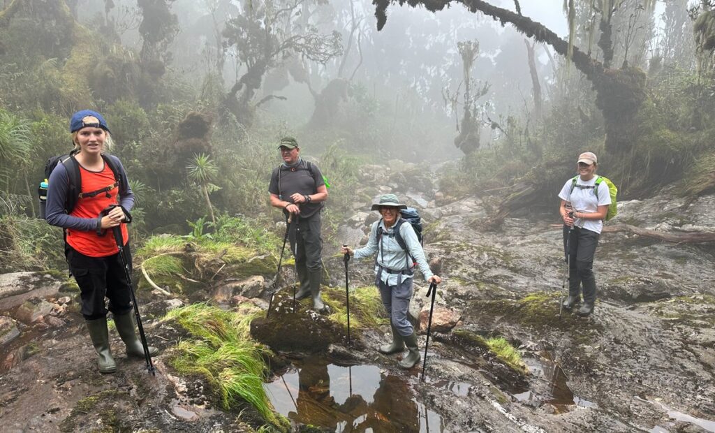
Leaving Sine Camp after breakfast, the trail immediately steepens into the Bamboo-Mimulopsis Zone. Bamboo grows thick on both sides, and the ground underfoot becomes a series of high-cut earth steps, slippery in wet conditions but manageable with trekking poles. Within an hour you reach a transition into the Heather-Rapanea Zone, where the vegetation opens slightly and Usnea lichen hangs in silver-grey curtains from twisted heather branches.
The mid-morning rest stop at Kalalama Camp (3,147 m) is a natural platform with views back along the Kilembe Valley. The trail continues climbing through a series of mossy ridges, crossing small creeks and passing waterfalls that cascade directly onto the path. The Namusangi Valley to the east carries mist through the trees, and the sound of running water is constant. This section of the Kilembe Trail is among the most atmospheric of any trekking route in Uganda.
Mutinda Camp, at 3,588 m, is positioned on a ridge with direct sightlines to the upper Rwenzori. An optional acclimatization ascent to Mutinda Lookout at 3,975 m rewards the effort with one of the finest viewpoints on the entire range: the peaks of Mount Stanley, Mount Baker, and Mount Speke are all visible on clear afternoons, along with Kasese town and the shimmering expanse of Lake George to the south. This afternoon acclimatization walk follows the climb-high-sleep-low principle and meaningfully reduces your altitude sickness risk on subsequent days. The huts at Mutinda are among the best on the Kilembe Trail: well-insulated, dry, and with solar lighting.
Day 3: Mutinda Camp (3,588 m) to Bugata Camp (4,062 m) | ~7 km | 5-6 hours
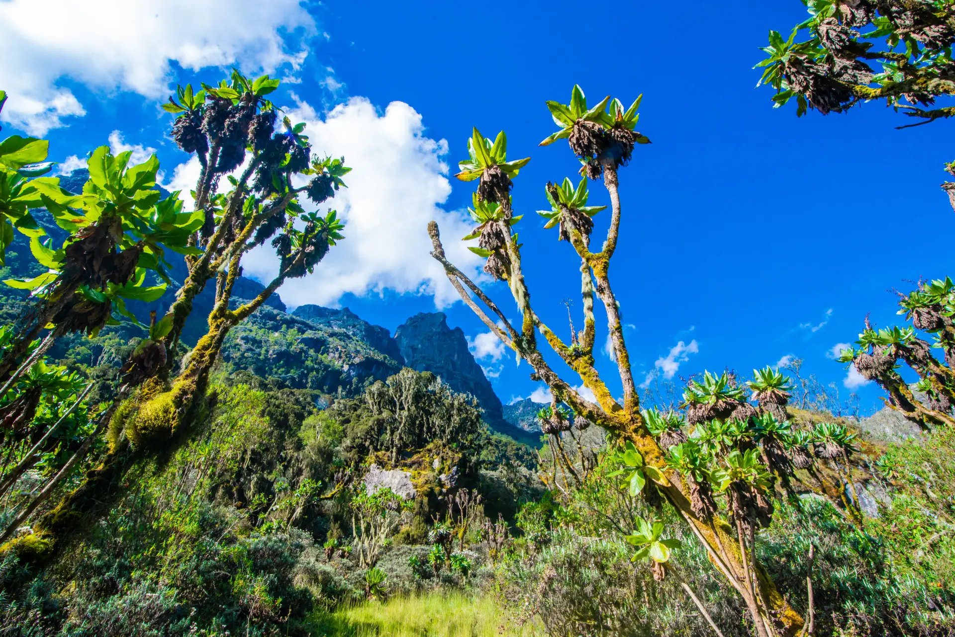
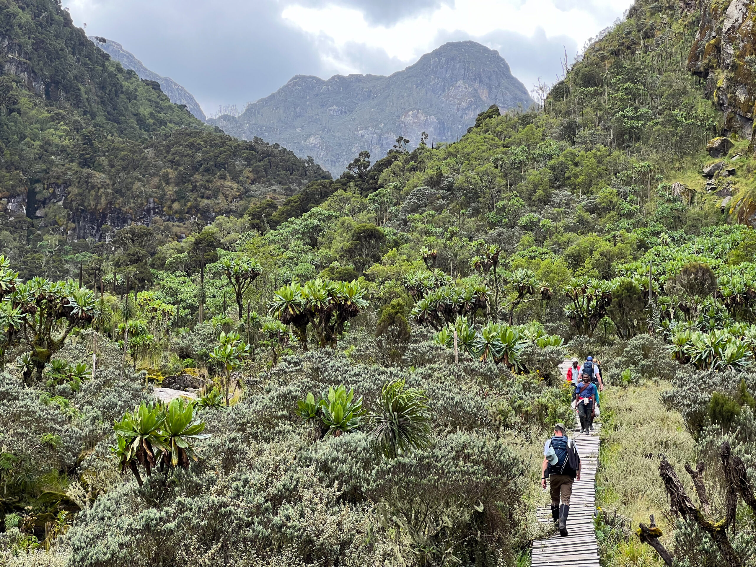
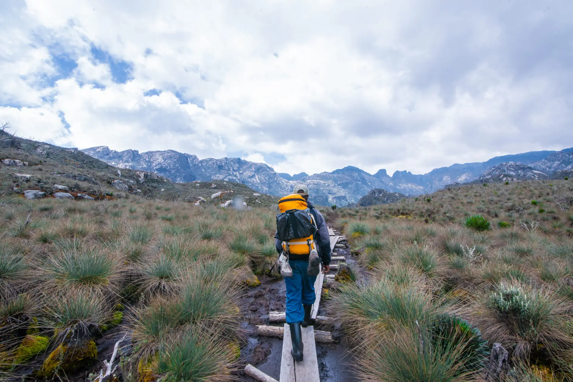
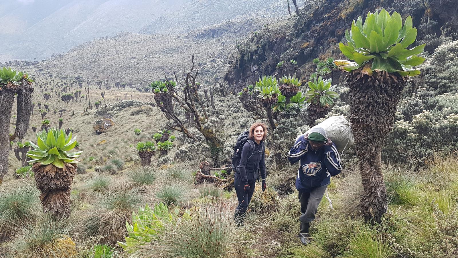
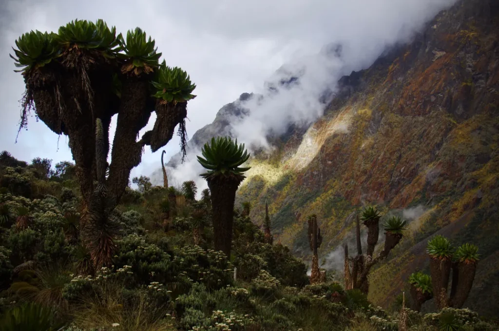
Day 3 carries you into the Afroalpine zone, the ecological heart of the Rwenzori Mountains and the section of this trail that most trekkers describe as the visual highlight of the first half of the expedition. The trail ascends through tussock grass and everlasting flowers before entering a valley dense with giant lobelias and groundsel. These prehistoric-looking plants, some of which stand four metres tall, represent one of the most vivid examples of Afro-alpine gigantism on Earth. The vegetation zones of the Rwenzori compress altitude ranges that span hundreds of kilometers on other African ranges into just a few vertical kilometers here.

The route traverses the Mutinda Valley and enters the Namusangi Valley at 3,840 m, where vertical waterfalls drop from the ridgeline directly into the bog below. Looking back from this section, the Mutinda Peaks form a dramatic skyline. The trail to Bugata is occasionally marshy, requiring careful navigation across tussocks, but your guide knows the best lines. Bugata Camp itself sits at 4,062 m above the broad Nyamwamba Valley, a compact, well-built hut exposed to wind but rewarded with extraordinary sky views. On clear nights, the stars above Bugata Camp are among the most vivid of any camp on the route.
What You Will See Between Mutinda and Bugata– Giant Lobelia wollastonii: flower spires reaching 3-4 m, unique to the Rwenzori – Senecio adnivalis (giant groundsel): silver-leafed rosettes on 2-3 m stems – Vertical waterfalls in the Namusangi Valley prime photography spots – Afroalpine grassland and everlasting flowers (Helichrysum) – First unobstructed views toward Mount Stanley and Margherita Peak |
Day 4: Bugata Camp (4,062 m) to Hunwick's Camp (3,974 m) via Bamwanjara Pass (4,450 m) | ~9 km | 6-7 hours
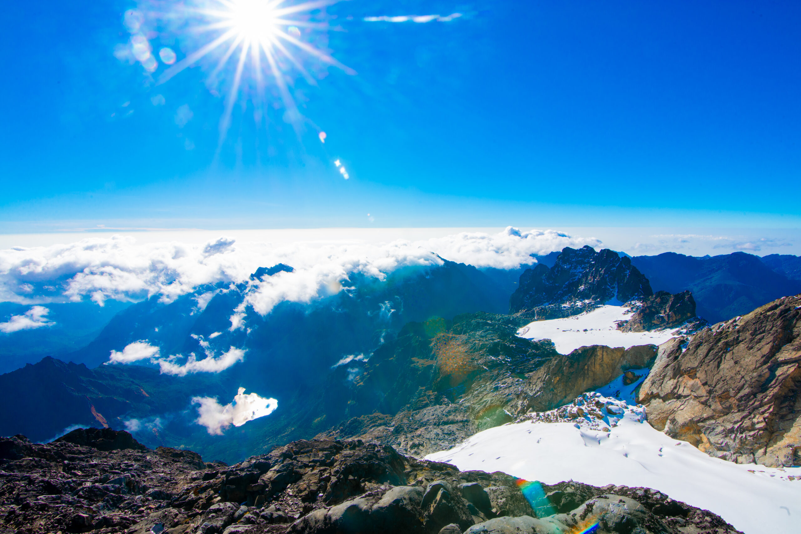
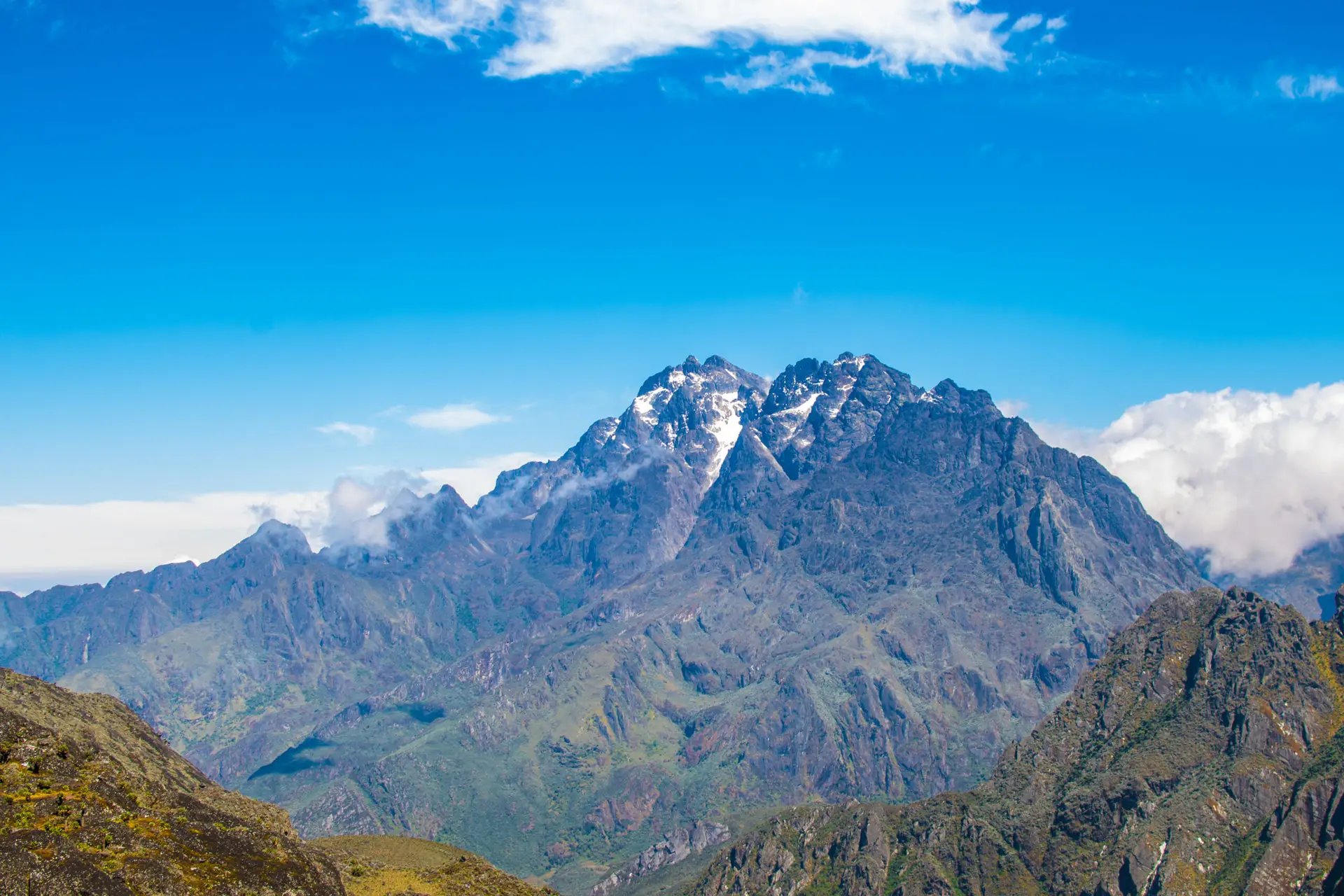
This is one of the most dramatic days on the entire Kilembe Trail. From Bugata, the trail climbs steeply to Bamwanjara Pass at 4,450 m, the highest point you will reach on foot before summit day. The emergency shelter at the pass is a useful waypoint and a natural viewfinder: on a clear morning, Mount Baker (4,843 m), Mount Stanley (5,109 m), and Margherita Peak all reveal themselves in sequence across the Bujuku Valley. For most trekkers, the view is the moment the summit stops being abstract and becomes a specific, visible place that they intend to stand on in two days.
The descent from the pass into the Kitandara Valley drops through evergreen thickets, lobelia meadows, and enormous groundsel before reaching a swamp section that is navigated via stones and tussock. The Malachite Sunbird is reliably seen here, a jewel-green bird with a curved bill that feeds exclusively on lobelia flowers and nests in the tussock at this altitude. The descent continues to Hunwick’s Camp at 3,974 m, a hut positioned on the edge of a wide valley with sweeping views toward Weismann’s Peak, McConnell’s Prong, and the south face of Mount Stanley. Dinner is served at the hut after a day that most trekkers describe as the most physically satisfying of the entire expedition.
Important: Weather WindowThe summit is most commonly attempted early morning on Day 6 to avoid the Congo cloud system that builds from the west between 10 a.m. and 2 p.m. Your guide assesses conditions daily from Bamwanjara Pass and Hunwicks Camp and will brief you on the summit weather pattern each evening. |
Day 5: Hunwick's Camp (3,974 m) to Margherita Camp (4,485 m) | ~5 km | 4-5 hours
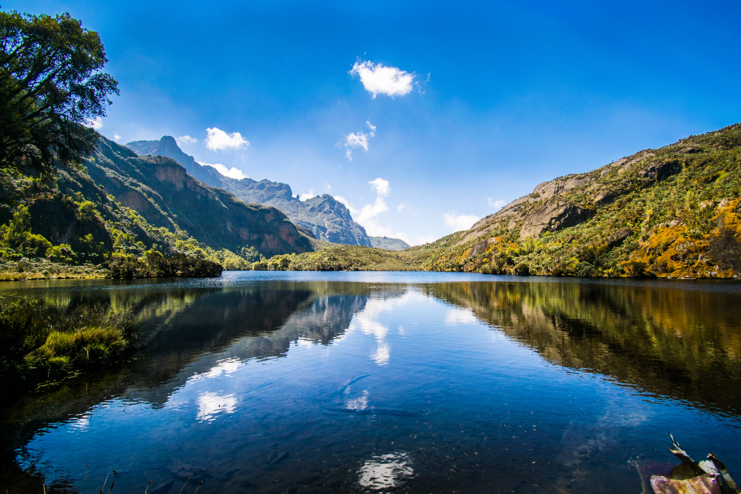
Day 5 is intentionally short. The distance from Hunwick’s to Margherita Camp is modest, but the purpose of the day is physical conservation and mental preparation. You descend from Hunwick’s, cross the valley floor, and arrive at the turquoise waters of Lake Kitandara, the same glacial lake encountered on the descent section of the Central Circuit route. On a calm morning, Kitandara reflects the surrounding ridgeline perfectly, and the stillness here is extraordinary.
From Kitandara, the trail climbs to Scott-Elliot’s Pass and continues upward onto the ridge toward Margherita Camp. The camp at 4,485 m is tucked between enormous boulders that shield it from the worst of the summit wind, a deliberate positioning that dates to 1906, when the Duke of Abruzzi used this exact location as his base camp during the first ascent of Margherita Peak. The historical weight of this place is tangible.
Arrive by early afternoon, eat a full hot dinner, and listen carefully to your guide’s summit briefing. The briefing covers the departure time, crampon and ice axe technique, rope protocol on the glacier, how to read weather conditions on the Stanley Plateau, and what to do if any team member shows altitude sickness symptoms above the glacier. Set everything out before sleeping: harness, helmet, gloves, balaclava, headtorch, summit layers, and be in your sleeping bag by 7:30 p.m.
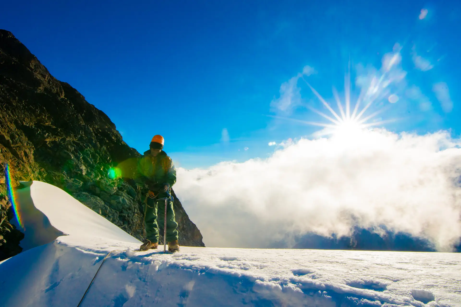
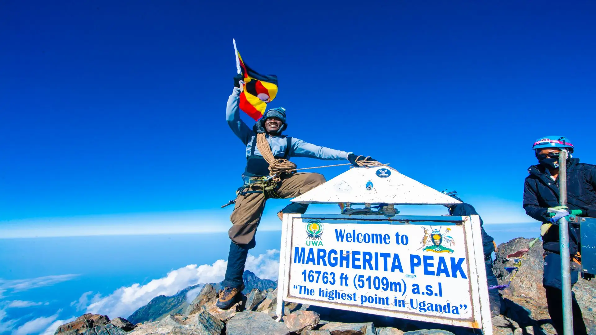
Day 6: Summit Margherita Peak (5,109 m) and Return to Hunwick's Camp (3,874 m) | ~10 km | 10-12 hours
Alarm at 1:45 a.m. Quick breakfast at Margherita Camp, ropes and crampons fitted at the glacier edge before 3:00 a.m., and the summit team moves onto the Stanley Plateau Glacier under headtorch. The cold is intense at this altitude before dawn, typically between -10 and -15 degrees Celsius, and any wind amplifies the chill sharply. Your layering system must be tested and in place before you leave the hut. If you have not already reviewed it, our summit layering and cold-weather guide is essential pre-trek reading.
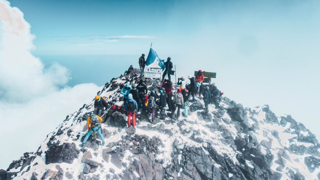
The Stanley Plateau Glacier is a crevassed ice field traversed via your guide’s chosen route and fixed ropes where needed. Above the plateau, the Margherita Glacier requires front-pointing on steeper ice with the ice axe in hand. Trekkers with limited mountaineering backgrounds find this section intimidating but manageable with a competent guide who has made this ascent over a hundred times. The summit of Margherita Peak, at 5,109 m, typically takes between 3 and 4 hours from Margherita Camp. Standing on Africa’s third-highest point at sunrise, above the Congo Basin clouds that are just beginning to form below you, is not something that requires embellishment.
After photographs, a moment of stillness, and a reading of the summit register, the descent back to Margherita Camp takes two to three hours. Lunch at the camp before continuing the descent to Hunwick’s Camp at 3,874 m. The return to lower altitude provides immediate physiological relief, and the evening at Hunwick’s is typically characterised by strong appetites and a quiet sense of achievement. The guides and porters celebrate here with their own quiet rituals, and visitors can observe them.
Summit Day Critical Gear Check– A sleeping bag rated to -10 C comfort must be used at Margherita Camp – Summit layers: thermal base, fleece mid-layer, insulated parka, waterproof shell – Headtorch with spare lithium batteries (standard alkalines fail in cold) – Crampons and ice axe: fitted and tested by your guide the evening before – Sunglasses rated for glacier UV: essential from first light on the ice |
Day 7: Hunwick's Camp (3,874 m) to Kiharo Camp (3,460 m) via Oliver's Pass (4,505 m) | ~12 km | 6-7 hours
The descent arc of the Kilembe Trail is as distinctive as its ascent. From Hunwick’s Camp, the trail follows a ridge toward McConnell’s Prong with clear sightlines back to Scott-Elliot’s Pass and the Three Peaks. The route climbs to Oliver’s Pass at 4,505 m, the final high-elevation crossing of the expedition, before making a sustained descent through the Kilembe and Nyamwamba river valleys.
Near where the Nyamwamba and Kilembe rivers meet, the descent goes past a geological landmark: a winding ridge of boulders and debris that were deposited by glacial movement and left behind as the ice retreated. This glacial moraine, a physical record of how far the ice once extended down the mountain, is a striking illustration of the glacial retreat story documented in our Rwenzori glacier guide. The valley opens up below the moraine, and the trail goes down to Kiharo Camp, which is at 3,460 m and is hidden away in a valley surrounded by rock walls and thick vegetation. The camp feels hidden from the mountain’s grand scale, warm and sheltered after the exposure of the high camps. Sleep here is typically excellent.
Day 8: Kiharo Camp (3,460 m) to Kilembe Trailhead (1,450 m) and Kasese | ~19 km | 6-7 hours
The final 19 kilometers from Kiharo Camp to the park gate and Trekkers Hostel are a long, satisfying walk down. The trail initially follows the river, and the forest closes quickly around you as the altitude drops. This section of the park holds the highest concentration of Rwenzori red duikers, small antelope often seen grazing in clearings beside the trail, especially in the mid-morning hours.
A few kilometers downstream, the river steepens, and a sequence of magnificent cascades fills the valley with white noise. From here the trail climbs briefly to a high ridge before the final descent through dense montane woodland to the Forest View Camp lunch stop. The last hour back to base camp passes through farmland and Bakonzo homesteads, the same landscape you entered eight days ago, now seen through entirely different eyes. Back at the Kilembe trailhead by mid-afternoon, you tip your porters, return hired equipment, and collect your summit certificate if you reached Margherita Peak. Most trekkers then spend the night in Kasese before onward travel.
From Kasese, the extension opportunities are excellent. Gorilla trekking in Bwindi Impenetrable Forest National Park takes approximately 3-4 hours by road. You can reach Queen Elizabeth National Park directly to the south in under 90 minutes. For trekkers who want to combine both experiences, our 12-Day Rwenzori and Gorilla Trek combo packages both into a seamless itinerary.
Elevation Profile: Eight Days of Altitude on the Kilembe Trail
The Kilembe Trail builds altitude more gradually than the Central Circuit in its opening days, reaching the highest sleeping camp (Margherita Camp at 4,485 m) on Day 5 one day later in the schedule. This additional day at mid-altitude is one of the reasons this route carries a slightly higher acclimatization buffer.
| Day 1 | Kilembe (1,450 m) to Sine Camp (2,596 m) (+1,146 m gain) |
| Day 2 | Sine Camp (2,596 m) to Mutinda Camp (3,588 m) (+992 m gain) |
| Day 3 | Mutinda Camp (3,588 m) to Bugata Camp (4,062 m) (+474 m gain) |
| Day 4 | Bugata (4,062 m) to Bamwanjara Pass 4,450 m to Hunwick’s (3,974 m) |
| Day 5 | Hunwick’s (3,974 m) to Lake Kitandara to Margherita Camp (4,485 m) |
| Day 6 | Margherita Camp (4,485 m) to Margherita Peak 5,109 m to Hunwick’s (3,874 m) |
| Day 7 | Hunwick’s 3,874 m to Oliver’s Pass 4,505 m to Kiharo Camp (3,460 m) |
| Day 8 | Kiharo Camp 3,460 m to Kilembe Trailhead (1,450 m) (-2,010 m descent) |
The two-pass structure of the Kilembe Trail (Bamwanjara Pass at 4,450 m on Day 4 and Oliver’s Pass at 4,505 m on Day 7) means you cross above 4,400 m twice without sleeping there, a powerful acclimatization strategy that follows the ‘climb high, sleep low’ principle. Read our detailed Rwenzori acclimatization guide for the full physiological explanation of how this strategy benefits your summit performance.
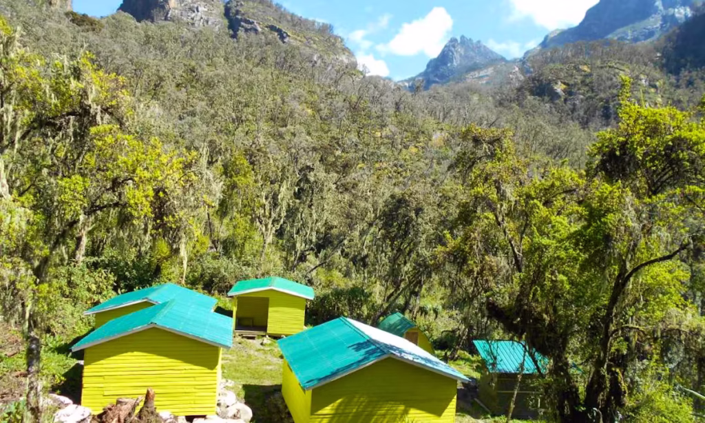
Camps and Mountain Huts on the Kilembe Trail
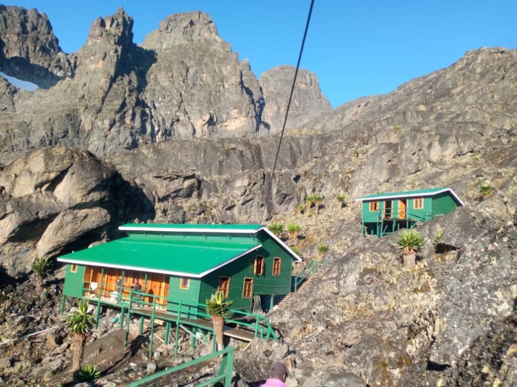
All accommodation on this trek is provided in Rwenzori Trekking Services (RTS) huts, which are widely regarded as the best-maintained mountain huts on the Rwenzori range. Each hut has wooden bunk beds with mattresses, a cook area for your mountain cook, and basic toilet facilities. Full descriptions of all huts on both trails are in our mountain accommodation guide.
Sine Camp | 2,596 m
The Day 1 camp, positioned in the upper montane zone above the main forest belt. The proximity of Enock’s Falls makes this one of the most pleasant camps on the trail. The surrounding vegetation is still dense, and the camp feels sheltered and warm by Rwenzori standards. Bird activity is high at dawn.
Mutinda Camp | 3,588 m
Positioned on a ridge in the heather zone with views toward the upper peaks. The optional acclimatization ascent to Mutinda Lookout (3,975 m) is strongly recommended and adds only 2-3 hours. The views from the lookout, Mount Stanley, Mount Baker, Mount Speke, Kasese, and Lake George are among the finest available without technical climbing.
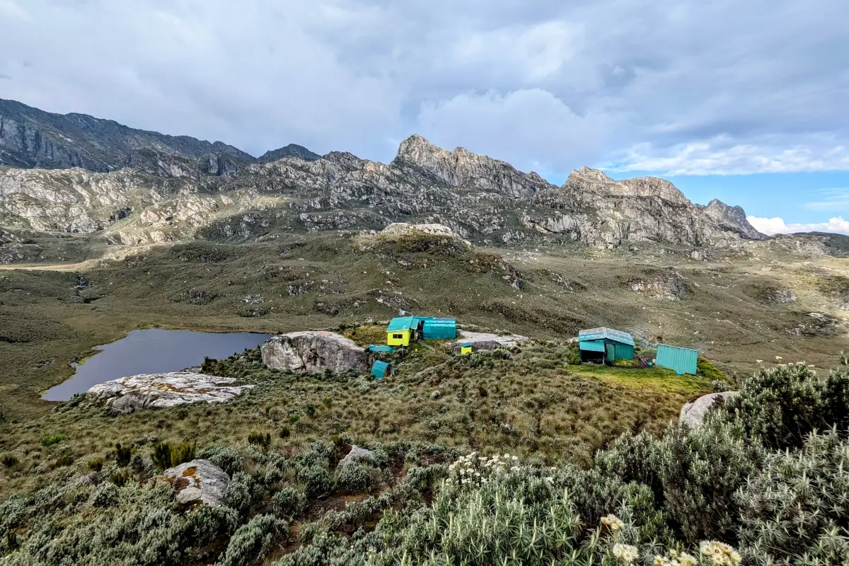
Bugata Camp | 4,062 m
High in the alpine zone above the Nyamwamba Valley. It is exposed to wind but extraordinary at night. The giant lobelia and groundsel fields visible from the hut door are at their densest here. The sky above Bugata Camp on clear nights is genuinely extraordinary. The camp sits above most cloud inversions, and the Milky Way is visible with exceptional clarity.
Hunwick’s Camp | 3,974 m
The logistical centerpiece of the expedition was used on both the Day 4 descent and the Day 6 return from the summit. Positioned on the edge of a wide alpine valley with views toward Weismann’s Peak, McConnell’s Prong, and Mount Stanley’s south face. The camp is spacious and well-constructed, with enough room for groups of up to 12. The post-summit evening here is typically the most celebratory of the week.
Margherita Camp | 4,485 m
The pre-summit high camp. Tucked between large boulders that break the worst of the wind and provide a degree of warmth otherwise absent at this altitude. Historically significant: the Duke of Abruzzi camped near this spot in 1906 during the first ascent of Margherita Peak. It is a small camp by design; your guide, cook, and essential porter will be with you here, with the full porter team waiting at Hunwick’s.
Kiharo Camp | 3,460 m
The penultimate camp on the descent, set in a sheltered valley with rock walls on three sides. It is warmer than the high camps and significantly more vegetated. The Kiharo Camp area holds some of the Kilembe Trail’s most concentrated Rwenzori red duiker activity. The sound of the river running beside the hut is a comforting constant after the silence of the glacier camps.
Flora and Wildlife Along the Kilembe Trail
The Kilembe Trail passes through all five of the Rwenzori’s ecological zones and offers wildlife encounters not available on the northern approaches. Our Rwenzori wildlife guide documents the range’s extraordinary biodiversity, which includes over 70 mammal species, 217 bird species, and thousands of endemic plants. The Kilembe route in particular is known for its birding on the lower trail and its botanical spectacle in the alpine zone.
Lower Montane Forest (1,450-2,600 m) Days 1 and 8

Blue monkeys, black-and-white colobus (groups of 15-20 are common), L’Hoest’s primates, and Rwenzori red duikers inhabit this zone. The Kilembe forest is part of the Albertine Rift Endemic Bird Area, the single most bird-diverse zone in mainland Africa. On clear mornings, expect to see the Rwenzori Turaco, the Black-and-white-casqued Hornbill, the African Green Broadbill, and the elusive Grauer’s Rush Warbler in the streamside vegetation.
Bamboo and Heather Zone (2,600-3,500 m) Days 2 and 8
Giant bamboo initially dominates, transitioning to tree heather draped in Usnea lichen. This zone is excellent for three-horned chameleons along the trail. At Mutinda Camp, hyraxes call from the heather and often perch on the lookout rocks. The handsome spurfowl and Rwenzori nightjar are both possible on calm evenings.
Afro-alpine Zone (3,500-4,500 m): Days 3, 4, 5, and 7.
The visual centerpiece of the trek is the stunning landscape is the stunning landscape. Giant Lobelia wollastonii flower spires, Senecio adnivalis groundsels, everlasting flowers, and tussock grass dominate the landscape from Bugata Camp upward. The Malachite Sunbird is reliably seen at Bamwanjara Pass and around the Kitandara Lakes, one of only a few places in Uganda where this species is regularly observed atfindch density. You can see the complete botanical breakdown in our Rwenzori vegetation zones guide.
Glacial and Rocky Zone (4,500+ m) Summit Day
Above Margherita Camp, plant life essentially ceases. Moraine, ice, and lichen-covered rock define the landscape. The retreat of the Stanley Plateau Glacier is visible in real time; exposed rock that was ice-covered as recently as a decade ago is now moraine. The summit itself stands at 5,109 m above a bank of Congo clouds, with views stretching to the horizon.
Difficulty, Fitness Requirements, and Altitude Considerations.
The 8-Day Kilembe Trail to Margherita Peak is a challenging mountaineering expedition. The terrain encompasses dense forest, steep bamboo, waterlogged bog, boulder fields, glaciated summits, and long ridge descents. Mud, cold, and sustained physical effort are permanent features, not occasional inconveniences. A comprehensive difficulty assessment is available in our Rwenzori difficulty guide.
Fitness Level Required
You should be capable of hiking for 6 to 8 hours consecutively on uneven terrain while carrying 5 to 8 kg. The extra day compared to the 7-Day Central Circuit means the daily distance averages slightly longer. A structured 10- to 12- week aerobic training program of running, cycling, stair climbing, or hill hiking is strongly recommended. See our Rwenzori fitness and training guide for a week-by-week program tailored to this trek.
Altitude and Acclimatisation
The maximum sleeping elevation on this trek is 4,485 m (Margherita Camp), and the maximum summit altitude is 5,109 m. Both are high enough to produce acute mountain sickness (AMS) in some trekkers. The Kilembe Trail’s acclimatization profile with the Mutinda Lookout climb on Day 2 and the Bamwanjara Pass crossing on Day 4 provides more altitude exposure at mid-elevation than the Central Circuit, which many trekkers and guides consider an advantage for summit day performance.
Altitude Safety ProtocolSymptoms of AMS: persistent headache, nausea, loss of appetite, difficulty sleeping. Manageable with rest and hydration at the same altitude. Symptoms of severe AMS: loss of balance, confusion, chest tightness, coughing blood. Tell your guide immediately. Descend without delay. Your guide carries supplemental oxygen. A descent of 500-1,000 m resolves most AMS cases within hours. Our complete medical guide covers all altitude conditions in detail |
Who Is This Trek For?
The 8-Day Kilembe Trail is ideal for experienced hikers who want the Rwenzori’s finest scenery alongside a genuine summit attempt. It suits those who prefer modern, well-maintained infrastructure and a slightly longer acclimatization arc. Hikers over 50 with maintained fitness complete this route regularly; see our guide for older trekkers. First-time Rwenzori trekkers with adequate preparation also succeed; our beginner’s guide addresses the most common preparation questions.
Best Time to Trek the Kilembe Trail
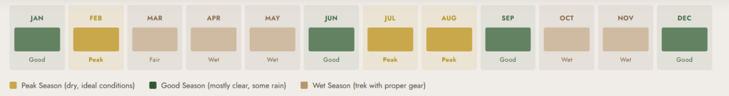
The Rwenzori receives rainfall year-round, and no month is completely dry. The range generates its own microclimate, and even during Uganda’s ‘dry’ seasons, you should expect rain on the mountain most days. What improves in the drier months is intensity and frequency, not absence. The full seasonal analysis is included in our best time to visit section, which is part of the Rwenzori guide.
| December to February | Best period. Lighter rainfall, clearer summit mornings. Most popular booking window. |
| June to August | Second dry window. Good summit conditions. Cooler temperatures at high camps. |
| March to May | Long rains. Heavy sustained rainfall. Trail conditions are harder. Not recommended for first timers. |
| September to November | Short rains. Manageable for experienced trekkers. Summit success rates slightly lower. |
A particular note about the Kilembe Trail: the waterfall sections that make Days 1 and 8 visually spectacular are even more dramatic during and after rain. The wet season has genuine aesthetic advantages on this route that compensate for the muddier conditions.
What’s Included in the 8-Day Kilembe Trail Package.
Included
- Uganda Wildlife Authority park entry permits (8 days)
- Professional certified Rwenzori mountain guide (English-speaking, first aid trained)
- Dedicated mountain cook and support staff
- Porter team (1 porter per trekker, max 15 kg per porter load)
- All meals on the mountain: breakfast, packed lunch, dinner, tea, and snacks
- Accommodation in established RTS mountain huts (shared basis)
- Summit glacier equipment: crampons, ice axe, harness, helmet
- Free loan of rubber boots in all standard sizes (mandatory for bog sections)
- Emergency supplemental oxygen carried by guide
Not Included
- International flights and transfers to Kasese (available on request; see our transport guide)
- Accommodation in Kasese before and after the trek
- Travel insurance required and must cover rescue above 5,000 m (see travel insurance guide)
- Tips and gratuities for guides, porters, and cook (see our tipping guide)
- Personal medications including altitude medication (Diamox / acetazolamide)
- Personal snacks, alcoholic beverages, and satellite communication devices
Packing List for the 8-Day Kilembe Trail
The Kilembe Trail demands gear suited to both tropical forests at 1,450 m and subzero glaciers at 5,109 m. Our comprehensive Rwenzori packing list covers every category in detail. The critical items specific to this route:

Waterproofs: Non-Negotiable.
- Waterproof jacket: seam-sealed, not just DWR-treated (pack it at the top of your daypack every day)
- Waterproof trousers (essential from Day 3 upward)
- Rubber boots: provided free of charge by RTS in all sizes: our boot guide explains when to wear rubber vs. your own boots
- Gaiters: strongly recommended from Day 2 onward
Insulation and Summit Layers
- Thermal base layer top and bottoms (merino wool or synthetic)
- Fleece or softshell mid-layer
- Insulating down or synthetic parka (rated for -10 C at Elena Hut or Margherita Camp)
- Waterproof hardshell jacket (over insulation on summit approach)
- Balaclava, heavyweight wool hat, and liner gloves plus warm outer mitts
Footwear
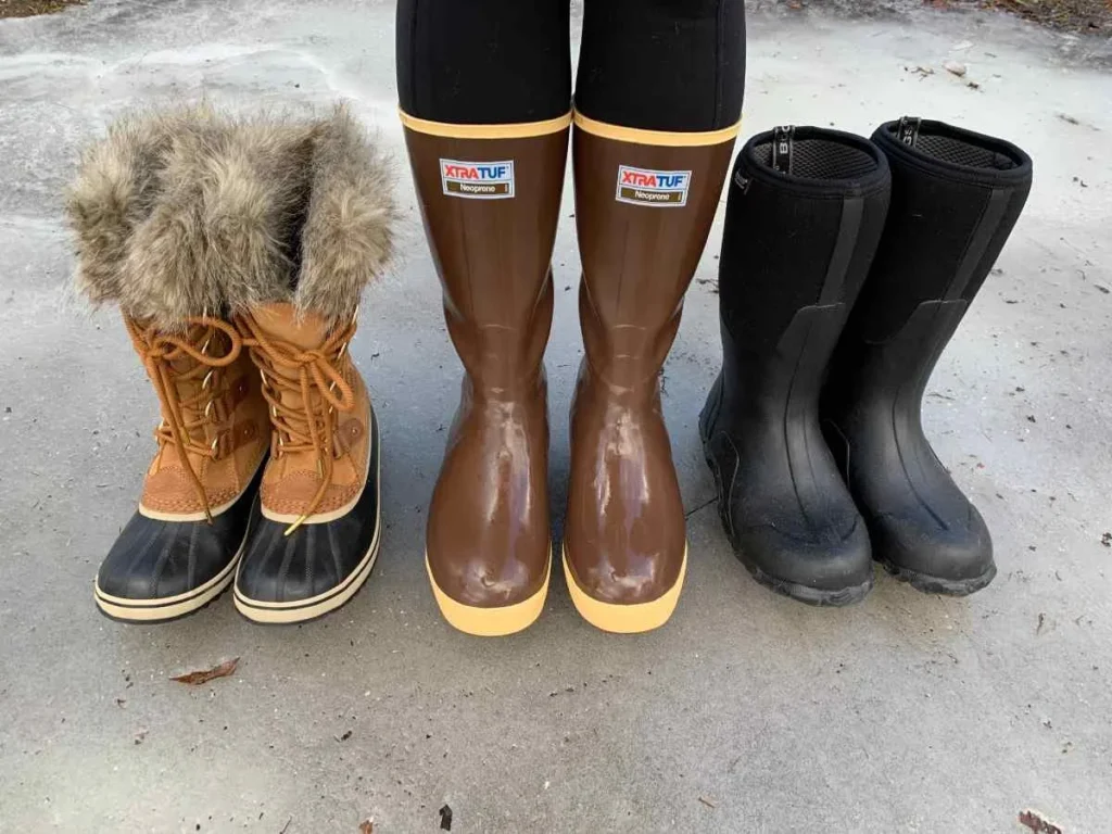
- Waterproof trekking boots (ankle support, used on Days 1-2 and descents)
- Gaiters and spare boot insoles
- Warm camp socks: 3 additional pairs for hut use
Technical gear, provided by RTS.
- Steel 10-12 point crampons
- Ice axe
- Climbing harness
- Helmet
General Equipment
- Trekking poles (strongly recommended; collapsible)
- Headtorch with lithium batteries; standard alkalines fail in freezing temperatures
- Daypack 25-35 litres for personal gear and summit day
- Duffel bag 80-100 litres for porter carry (no rigid suitcases)
- Sleeping bag rated to -10 C (comfort rating, not limit)
- Sunscreen SPF 50+ and UV-protection sunglasses (glacier reflection is severe)
- Water purification tablets or filter
- Personal first aid kit, including blister treatment and personal medications
Permits, Park Fees, and Full Cost Breakdown
The 8-Day Kilembe Trail trek is priced from USD 1,705 per person, inclusive of all park fees, guiding, porter support, meals, hut accommodation, and summit glacier equipment. A full itemized breakdown of every cost component is available at our Rwenzori cost guide.
| Package Price | From USD 1,705 per person (all-inclusive on the mountain) |
| UWA Park Entry | Included in package price |
| Guide Fees | Included |
| Porter Fees | Included (1 porter per trekker, max 15 kg) |
| Meals (8 days) | All on-mountain meals included |
| Hut Accommodation | Included (RTS huts, 7 nights) |
| Summit Glacier Equipment | Included (crampons, ice axe, harness, helmet) |
| Rubber Boots | Free loan from RTS in all standard sizes |
| Guide Tips | Not included; approx. USD 10-15/day recommended |
| Porter Tips | Not included; approx. USD 5-8/day recommended |
| Pre/Post-Trek Accommodation | Not included; see our Kasese accommodation guide |
Group discounts apply for parties of four or more trekkers. Solo trekkers are paired with other single bookings on shared departures, or a private departure can be arranged for a supplement. All prices are quoted in USD and are valid for the 2026/2027 seasons. Contact us for a personalized quote.
Getting to the Kilembe Trailhead: Transport and Logistics
The Kilembe trailhead is located in Kilembe village, approximately 12 km from Kasese town on the road toward the Rwenzori range. Kasese is the primary gateway town for both Kilembe Trail and Central Circuit departures. Full transport logistics from Kampala, Entebbe, and Kenya are covered in our how-to-get-to-the-Rwenzori guide.
From Kampala and Entebbe
By private charter vehicle: 5-6 hours from Entebbe International Airport, 6-7 hours from Kampala city center. This is the most comfortable option and can be arranged by Rwenzori Trekking Safaris. By bus: daily services from Kampala (Kisenyi or Nakulabye stages) reach Kasese in 7-9 hours. Arrive the evening before your trek departure date to allow for an early-morning trailhead transfer.
Kasese Town
Kasese has a range of guesthouses and hotels for all budgets. Our Kasese travel guide covers accommodation options, ATM locations, pre-trek meals, and the transfer logistics from Kasese to the Kilembe trailhead on Day 1. Allow 20-30 minutes from Kasese town center to the RTS base camp.
Trailhead Transfer
Rwenzori Trekking Safaris coordinates trailhead transfers from Kasese to the Kilembe RTS base camp on the morning of Day 1. This is approximately 20-30 minutes by vehicle and is included in most standard package arrangements. Confirm transfer requirements when you book.
Book Your Slot
Respond within Minutes
From
$1,705
per person
- Duration 8 Days / 7 Nights
- Group Size 1–12 people
- Start Point Kilembe TrailHead
- Departures Year-round
- Summits Margherita Peak
No booking fee. Free cancellation up to 30 days before departure. We respond within Minutes.
Explore Related Rwenzori Expeditions
7-Day Rwenzori Central Circuit to Margherita Peak
The established classic from the northern approach is one day shorter.
$1,400 Per Person
$1,400 Per Person
4-Day Rwenzori Waterfalls Hike via Kilembe Trail
The scenic Kilembe lower trail without the summit commitment.
$615 Per Person
$615 Per Person
13-Day Six Peaks Grand Expedition
Summit all six major Rwenzori peaks, including Margherita, Speke, Baker, Emin, Gessi, and Luigi di Savoia.
$3,350 Per Person
$3,350 Per Person
12-Day Rwenzori + Gorilla Trek Combo
Combine the Kilembe Trail summit with mountain gorilla trekking in Bwindi.
$5,800 Per Person
$5,800 Per Person
Everything you need to know before booking your 8-Day Kilembe Trail Rwenzori Trek.
How does the 8-Day Kilembe Trail compare to the 7-Day Central Circuit in terms of difficulty?
Both routes are classified as challenging, and they both summit Margherita Peak. The 8-Day Kilembe Trail is slightly longer in total distance and has two high passes (Bamwanjara at 4,450 m and Oliver’s at 4,505 m) compared to the Central Circuit’s one (Scott-Elliot at 4,372 m). The Kilembe Trail infrastructure is generally considered superior: better huts and more recent maintenance. The Central Circuit has a longer operational history and a slightly higher average summit success rate owing to its more compact altitude arc.
A detailed comparison of both routes is available at our Central Circuit vs Kilembe Trail Guide.
Do I need glacier or mountaineering experience to summit Margherita Peak via the Kilembe Trail?
No prior glacier or technical mountaineering experience is required. Your guide teaches crampon fitting, ice axe arrest technique, and rope protocol at the glacier edge on summit morning before the team begins the ascent. The vast majority of trekkers on this route have never worn crampons before. Physical fitness, appropriate cold-weather gear, and confidence in following guide instructions matter far more than technical background.
What are the best wildlife encounters specific to the Kilembe Trail?
The Kilembe Trail’s lower forest section is particularly rich in primates; black-and-white colobus groups of 15-20 are commonly seen on Day 1, and L’Hoest’s monkey and blue monkey are both regularly encountered. The Malachite Sunbird at Bamwanjara Pass is a highlight unique to the Kilembe approach. Rwenzori red duikers are most frequently seen in the Kiharo Valley on Day 7 and during the final descent on Day 8. The trail’s waterfall sections make it exceptional for macro photography of mosses, ferns, and invertebrates.
What is the summit success rate on the 8-Day Kilembe Trail?
Rwenzori Trekking Safaris maintains a strong summit success rate on the 8-day Kilembe itinerary. The main variables are trekker fitness level, cold-weather gear quality, and the presence of any altitude sickness symptoms. The acclimatization profile of the Kilembe Trail, with its Mutinda Lookout and Bamwanjara Pass exposures, is considered beneficial for summit performance. A full analysis of the factors that determine success is available on our Summit Success Guide.
Can I combine the Kilembe Trail with a gorilla trek in Uganda?
Yes. This is one of the most popular combinations in Uganda. After completing the Kilembe Trail and spending a night in Kasese, the journey to Bwindi Impenetrable Forest National Park takes 3-4 hours by road.
Our 12-Day Rwenzori and Gorilla Trek package and the 16-Day Rwenzori, Gorillas, and Chimps package both incorporate this combination seamlessly.
How cold does it get at Margherita Camp, and how should I prepare?
Margherita Camp at 4,485 m experiences overnight temperatures typically between -5 and -10 degrees Celsius, with wind chill potentially lower. A sleeping bag rated for at least a -10 C comfort rating is non-negotiable here. Summit morning before dawn on the glacier, ambient temperatures reach -10 to -15 degrees, sometimes lower with wind chill. Every layer of your cold-weather system needs to be tested and complete before departure from Kasese. A full layering guide with specific product recommendations is available on our website.
Is the Kilembe Trail busier or quieter than the Central Circuit?
The Kilembe Trail is quieter. The overall Rwenzori receives fewer than 1,500 trekkers annually, a tiny fraction of Kilimanjaro’s 50,000+, and the Kilembe Trail takes a smaller share of those than the Central Circuit. It is entirely normal to spend days on the trail without encountering another trekking group. This solitude is one of the route’s defining qualities.
What food is provided on the 8-Day Kilembe Trail?
A trained mountain cook prepares three hot meals daily plus tea, coffee, and snacks. Breakfast includes porridge, eggs, toast, and hot drinks. Lunch is a packed meal of bread, protein, fruit, and energy snacks. Dinner is a hot cooked meal: rice, pasta, or ugali with stew, beans, or lentils. Vegetarian and vegan options are fully catered. Declare dietary requirements at the time of booking. You will not go hungry. Trekker reviews consistently note the quality of cooking on the Kilembe Trail.
What should I do in Kasese the day before my trek starts?
Arrive in Kasese the evening before your trek departure. Use the afternoon to confirm your gear list is complete, visit the RTS base camp if open for a briefing, and eat a substantial dinner. Our Kasese travel guide covers where to stay, where to eat, local ATMs, and what to expect on the drive to the Kilembe trailhead.
How far in advance should I book the 8-Day Kilembe Trail trek?
We recommend booking at least 3 to 4 months in advance for December to February and June to August departures. Park permit availability is controlled by the Uganda Wildlife Authority and is limited. A 30% deposit secures your reservation; the balance is due 30 days before departure. Last-minute bookings are occasionally possible outside peak months; contact us to check availability.
Is the Kilembe Trail suitable for solo trekkers?
Yes, and many trekkers choose this route specifically because its relative quietness makes it feel more like a personal expedition. Solo trekkers are assigned a personal guide and porter. You can join a shared departure with other solo trekkers or book a completely private expedition. The route’s logistics are well-suited to small groups, and the guide team is highly experienced in supporting solo clients.
Ready to Climb the Kilembe Trail to Margherita Peak?Our guides have walked every meter of this trail in every season. They know which bogs freeze at night, where the sunbirds gather at Bamwanjara Pass, and how to read the glacier at 5,000 metres. Let them lead you there. Email: rwenzoritrekkingsafaris@gmail.com WhatsApp: +256 773 256 104
|