Summit all 6 Rwenzori peaks in 13 days: Gessi, Emin, Speke, Margherita (5,109 m), Baker & Weismann. Expert-guided expedition on Africa’s Mountains of the Moon.
13-Day Rwenzori 6 Peaks Expedition | Complete Circuit
13-Day Rwenzori 6 Peaks Expedition: The Ultimate Grand Circuit.
Summit All Six Major Rwenzori Peaks: Gessi, Emin, Speke, Margherita, Baker & Weismann on Africa’s Most Ambitious Multi-Peak Trekking Expedition
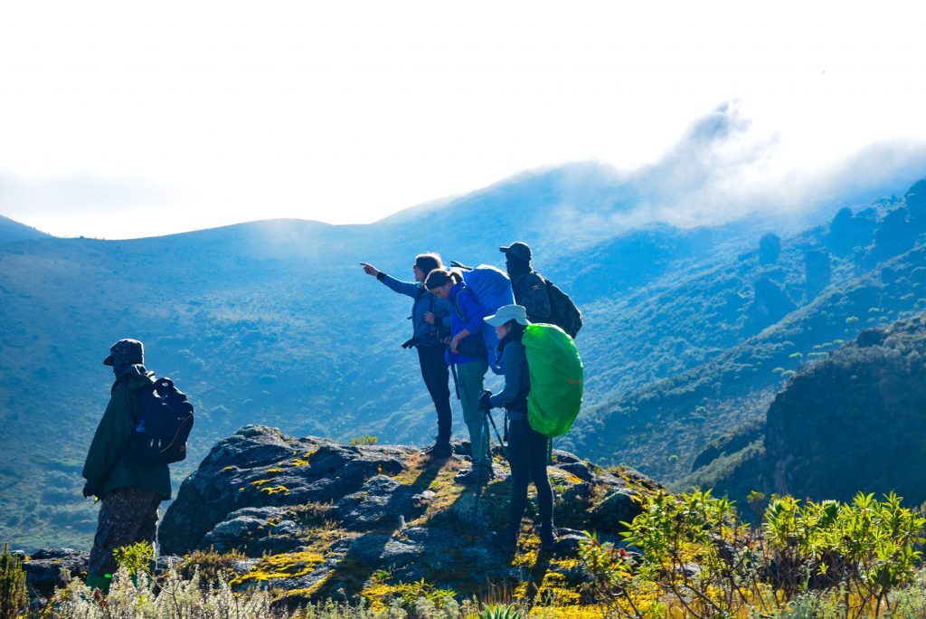
There are mountain expeditions, and then there is this. The 13-Day Rwenzori 6 Peaks Expedition is the most comprehensive multi-summit trekking challenge available in Africa’s Rwenzori Mountains, a route that carries you across the full breadth of the Central Circuit Trail while demanding the summits of every one of the six major massifs. By the time you descend from Weismann Peak on Day 13, you will have stood on six separate summits above 4,600 metres, crossed glacial passes, camped in primordial fog, and witnessed a landscape that most trekkers on this continent will never see.
This is not a standard Rwenzori trek with a single summit objective. It is an expedition in the truest sense of the word, 13 days deep in one of the world’s most botanically extraordinary mountain ranges, navigating bogs, heather forests, groundsel groves, and the Stanley Glacier on your way to Margherita Peak at 5,109m, Africa’s third-highest point. The trek attracts experienced alpinists, seasoned East African trekkers, and those who simply want to do the Rwenzori the way it was meant to be done completely.
Fewer than 1,500 people trek the Rwenzori in any given year. Of those, only a fraction attempt all six peaks. If you are ready for what the Mountains of the Moon truly demand, this is your expedition.

Embark on the ultimate 13-day trekking adventure through Uganda’s mystical Rwenzori Mountains, summiting six iconic peaks: Mount Gessi, Mount Emin, Mount Speke, Cheptegei Peak (Stanley), Mount Baker, and Weismann Peak. Traverse lush montane forests, vast alpine meadows, and glacial valleys while experiencing wild camping under the stars. Witness breathtaking sunrises from Africa’s third-highest summit, Margherita Peak (5,109 m), and explore rugged landscapes where few have ventured.
Designed for experienced mountain trekkers, this expedition promises a once-in-a-lifetime journey through some of Africa’s most remote and awe-inspiring terrains. Get ready for 13 days of pure adventure, dramatic vistas, and unforgettable memories in the legendary Mountains of the Moon.
13-Day 6 Peaks Expedition At a Glance.
| Duration | 13 Days / 12 Nights |
| Peaks Summited | Mount Gessi (4,715 m), Mount Emin (4,798 m), Mount Speke (4,890 m), Margherita Peak/Mount Stanley (5,109m), Mount Baker (4,843 m), Weismann Peak/Mount Luigi di Savoia (4,627 m) |
| Total Distance | Approximately 95-105 km (includes peak ascents) |
| Max Elevation | 5,109 m Margherita Peak, Africa’s 3rd Highest Summit |
| Difficulty | Very Strenuous Expert/Advanced Trekkers Only |
| Start / End Point | Nyakalengija Gate (1,650m) |
| Trek Route | Central Circuit Trail, Rwenzori Mountains National Park |
| Best Season | December-March & June-August (drier months) |
| Group Size | 2-12 trekkers (private expeditions available) |
| Accommodation | Mountain huts + wild camping at peak camps |
| Price Indicator | From USD 3,350 per person (all-inclusive) |
| Park Authority | Uganda Wildlife Authority (UWA) |
| Guides & Porters | Certified Rwenzori guides + porters included |
Why Choose the 13-Day 6 Peaks Expedition?
The Rwenzori Mountains National Park is a UNESCO World Heritage Site unlike any other mountain environment on Earth. Its peaks are permanently draped in equatorial clouds, its valleys are carpeted in giant heather and otherworldly giant lobelias, and its bogs are the kind of terrain that demands rubber boots and genuine commitment. The 13-Day 6 Peaks Expedition is the only standard itinerary that allows you enough time to experience every ecological zone, every major summit, and every mood this mountain has.
Compare this trek to the 7-Day Margherita Peak climb, already a serious undertaking, and you begin to understand the scale of the commitment involved here. The shorter treks focus on a single summit objective. This expedition turns the entire massif into your playground. You will summit Mount Gessi (4,715 m), Mount Emin (4,798 m), Mount Speke (4,890 m), Margherita Peak on Mount Stanley (5,109 m), Mount Baker (4,843 m), and Weismann Peak on Mount Luigi di Savoia (4,627 m), all six of the Rwenzori’s major massifs, in a single continuous traverse.
The Rwenzori is also genuinely difficult in a way that other East African mountains are not. The terrain is relentlessly wet, technical, and demanding. Rain is frequent at all elevations. The bogs require physical effort just to cross. This is what makes the 13-day expedition such a powerful experience: every summit feels earned, every camp feels hard-won, and the landscape never loses its sense of wild, primal remoteness. For those who have summited Kilimanjaro and found it too crowded, too straightforward, or too predictable, the Rwenzori answers every one of those frustrations. Read our honest Rwenzori vs. Kilimanjaro comparison to understand the full difference.
The glaciers on these peaks are shrinking. Scientists project that the Rwenzori’s equatorial ice will largely disappear by 2050. The 13-Day 6 Peaks Expedition is, among other things, a rare chance to stand on glacial ice in equatorial Africa while that option still exists. The urgency is real.
Full Day-by-Day Itinerary: 13 Days, 6 Rwenzori Peaks Expedition, Central Circuit Trail
Day 1: Nyakalengija Gate (1,650 m) to Nyabitaba Camp (2,652 m)
| Elevation | Distance | Hiking Time | Accommodation |
| 2,652 m | 6.5 km | 4-6 hours | Nyabitaba Hut |
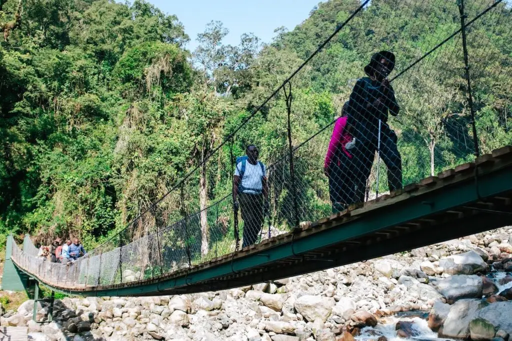
The expedition begins at Nyakalengija Gate, the entry point into the Rwenzori Mountains National Park, located approximately 22 kilometers from Kasese town. Your guide team will meet you at the gate for a full pre-trek briefing, equipment checks, safety protocols, and an introduction to the mountain environment ahead. This is also where porters are assigned and loads distributed.
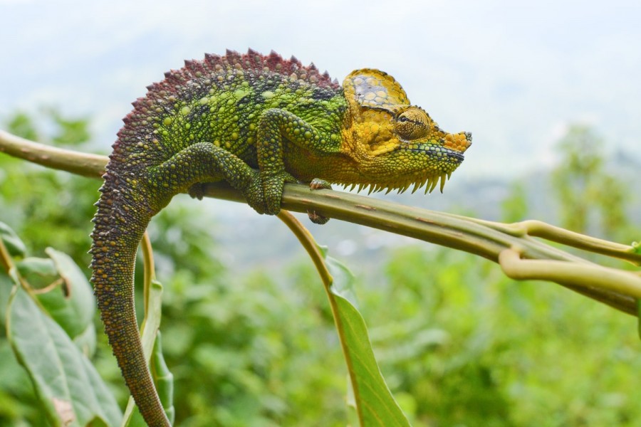
From the gate, the trail climbs steadily through dense montane rainforest, the kind of forest that feels ancient and alive in equal measure. You will cross several rivers via wooden and steel bridges, including the crossing above the Mubuku River gorge, and navigate a series of steep ladder sections bolted into exposed cliff faces. The forest here is rich in Rwenzori wildlife. Rwenzori turacos flash their crimson wings through the canopy, olive sunbirds flit through flowering shrubs, and the calls of Rwenzori red duikers sometimes carry from the undergrowth.
After approximately 4 to 6 hours of ascent, you arrive at Nyabitaba Camp, a sturdy hut perched on a ridge at 2,652 metres with sweeping views east towards the Portal Peaks. The camp has bunk sleeping, a dining area, and a basic cooking shelter. Your mountain cook serves dinner here, and the evening mist rolling up the valleys below gives the camp a genuinely atmospheric quality. Tonight, you begin to understand what the next 12 days will feel like.
Guide’s Tip:The climb to Nyabitaba is a solid warm-up day, but do not underestimate it. The final ladder sections are steep and exposed. Take your time, stay hydrated, and let your body settle into a mountain rhythm. Tonight’s rest is important; tomorrow is a much longer day. |
Day 2: Nyabitaba Camp (2,652 m) to John Matte Camp (3,505 m)
| Elevation | Distance | Hiking Time | Accommodation |
| 3,505 m | 9 km | 8-10 hours | John Matte Hut |
This is the longest and most physically demanding day of the first half of the expedition. You leave Nyabitaba Camp immediately after breakfast and descend to the Kurt Schafer Bridge, a historic crossing point at the confluence of the Mubuku and Bujuku rivers. The roar of the two rivers meeting in the valley below is a defining sound of the Rwenzori. Spend a moment here, because it is genuinely memorable.
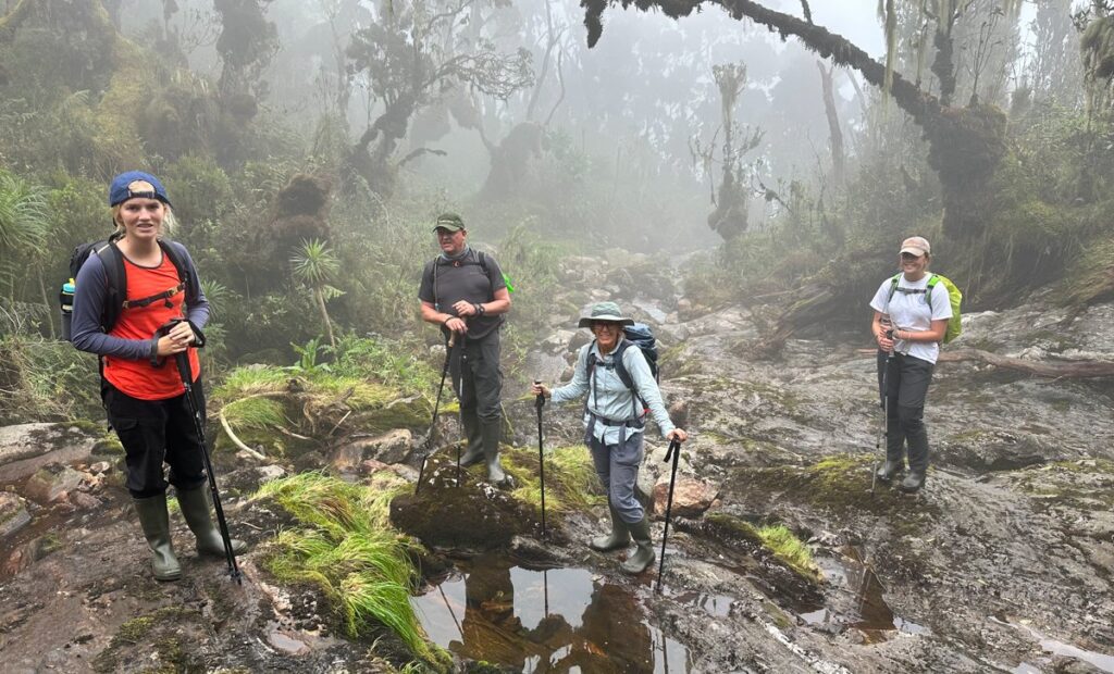
From the bridge, the trail ascends significantly into the bamboo zone, a stunning belt of forest where the path tunnels through dense stands of Arundinaria alpine bamboo. Around 3,000 metres, the bamboo gives way to the hagenia-hypericum woodland zone, characterised by twisted heather trees draped in old man’s beard lichen. The air feels thicker here with moisture, and the trail becomes progressively muddier as you gain altitude.
A rest stop at Nyamuleju shelter (approximately 3,100 m) breaks the day’s ascent before the final push across the Bujuku River and up into the open mossy woodland above. John Matte Camp sits at 3,505 metres and is one of the better-equipped huts on the Central Circuit Trail, with comfortable bunks, a communal dining space, and a water supply from a nearby stream. The panoramic view of the Rwenzori peaks on a clear evening from John Matte is considered one of the finest camp vistas on the entire mountain.
Day 3: John Matte Camp (3,505 m) to Skull Cave Camp (3,950 m)
| Elevation | Distance | Hiking Time | Accommodation |
| ~3,950 m | 7 km | 5-7 hours | Skull Cave (Wild Camp) |
Today marks your transition from the forested lower mountain into the true afro-alpine zone. Leaving John Matte, the trail climbs through the Rupenia heather belt, a zone of extraordinary botanical character where heather trees grow to several metres in height and the forest floor is padded with thick Sphagnum moss. The light filters green and gold through the heather canopy on clear mornings, making this one of the most photogenic sections of the entire circuit.
Bird spotters should move slowly here. This zone supports high concentrations of Rwenzori endemic bird species, including the Rwenzori turaco, Lagden’s bush-shrike, and the handsome spurfowl. Giant lobelias begin to appear at around 3,700 metres, their enormous rosettes forming and rising above the heather in sculptural isolation.
Skull Cave is a wild camping site at approximately 3,950 metres, with a rock overhang that has served as a mountain shelter for generations. Ground tents are pitched on the flat area beneath and around the cave. This is your first taste of true high-altitude wild camping on this expedition, and it sets the mood for the peak days ahead. The night sky at Skull Cave, cloud-free nights permitting, is extraordinary. Temperatures will drop significantly; ensure your sleeping bag rating is appropriate.
Important: Gear Check at Skull CaveTonight is the last camp before your first summit attempt. Check all cold-weather gear, headlamp batteries, and crampon fittings with your guide this evening. See our full packing guide for the Rwenzori for a complete equipment checklist. |
Day 4: Skull Cave Camp to Lac de la Luna Camp (4,100 m)
| Elevation | Distance | Hiking Time | Accommodation |
| ~4,100m | 5 km | 4-6 hours | Lac de la Luna (Wild Camp) |
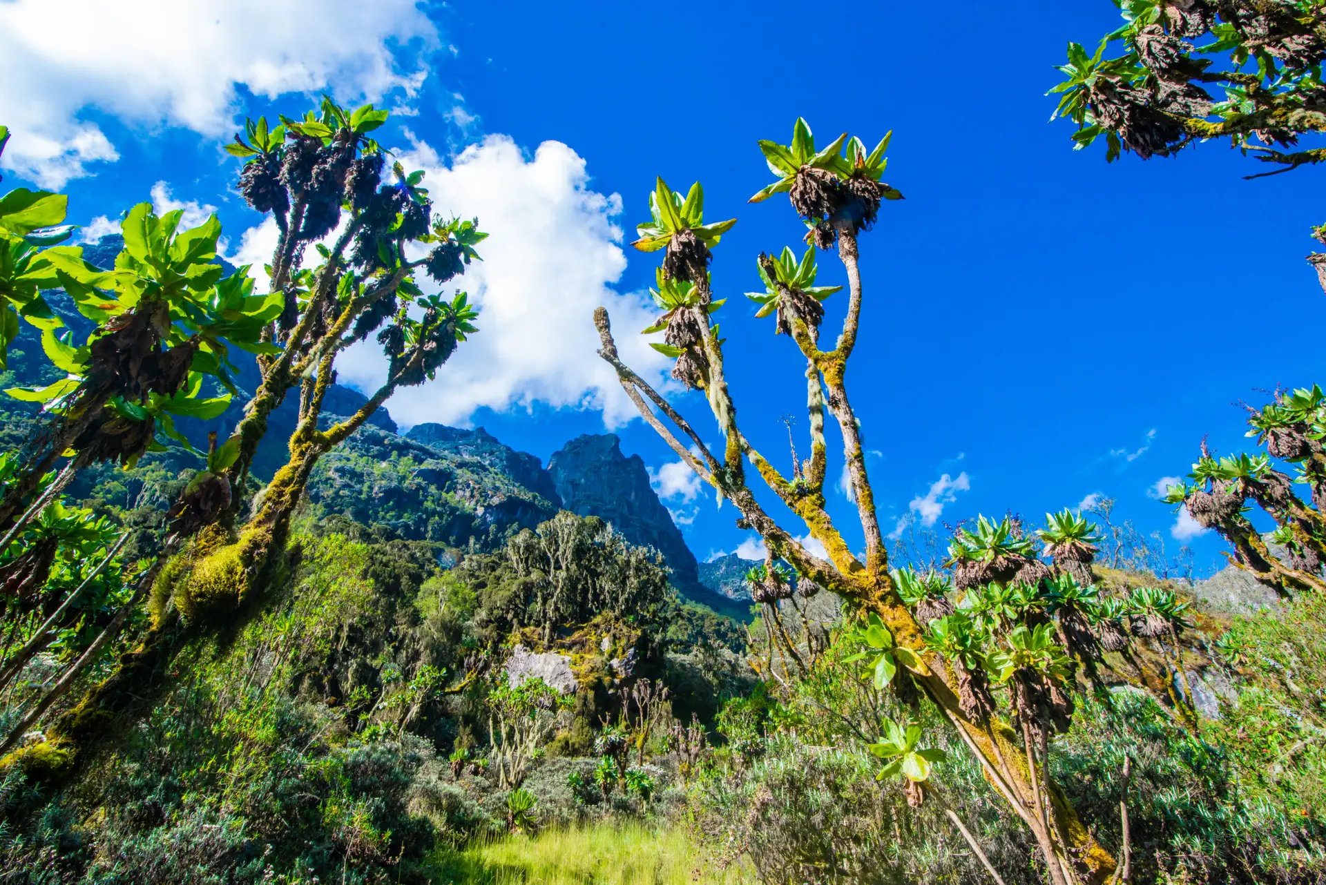
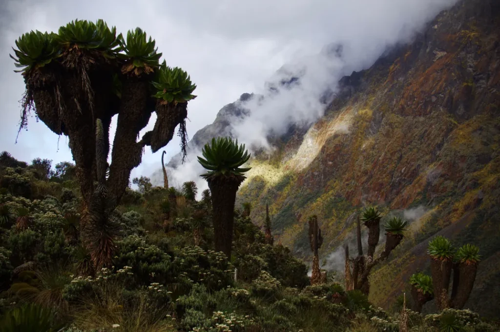
From Skull Cave, the route climbs higher into the upper Afroalpine zone. The terrain becomes increasingly rocky and exposed as the heather thins and the giant groundsels (Dendrosenecio rwenzoriensis), an extraordinary tree-like plant unique to these altitudes, begin to dominate the landscape. These prehistoric-looking plants, with their massive rosette crowns and thick cabbage-like trunks, are one of the defining visual signatures of the Rwenzori.
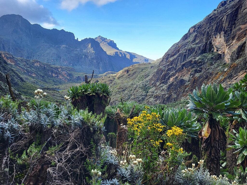
As you gain altitude, the views opening to the west reveal the forested ridges of the Democratic Republic of the Congo across the Albertine Rift, a perspective experienced by very few trekkers worldwide. On clear days, the DRC lowlands stretch to the horizon in a vast green panorama that contextualizes the extraordinary elevation you have reached.
Lac de la Luna is a high glacial lake camp at approximately 4,100 metres, ringed by rocky outcrops and boggy ground. The lake’s still, dark surface reflects the surrounding peaks on calm evenings. This is your base for the first two summit days. Tents are pitched in sheltered spots around the lake margin, and your cook team will have a warm, high-calorie dinner waiting when you arrive.
Day 5: Summit Mount Gessi (4,715m), Return to Lac de la Luna
| Elevation | Distance | Hiking Time | Accommodation |
| 4,715m summit | 8-10 km return | 6-8 hours | Lac de la Luna (Wild Camp) |
Your first summit of the expedition. Mount Gessi rises to 4,715 metres and its principal summit, Iolanda Peak, demands a confident ascent over boulder fields and scree. The route from Lac de la Luna begins with a steep traverse across rocky moorland before the final boulder-scramble to the summit ridge. The rock here is ancient crystalline schist, part of the Rwenzori’s Precambrian geological formation, and it provides solid hand and footholds for confident scramblers.
The summit views from Gessi are sweeping and dramatic in every direction. To the west, the Congo Basin extends towards the horizon. To the northeast, the higher Rwenzori peaks, Emin, Speke, and Stanley, form an imposing line of summits that you will visit over the days ahead. Allow time on the summit before beginning the descent, which is equally demanding on weary legs over loose rock.
Return to Lac de la Luna camp for the afternoon and a well-earned rest. Tonight is a recovery meal and early rest. Mount Emin awaits tomorrow.
Summit 1 of 6: Mount Gessi, 4,715 mGessi is a bouldering and scrambling summit; no technical climbing equipment is required, but confident footwork over loose rock is essential. Follow your guide’s exact line on the descent. |
Day 6: Summit Mount Emin (4,798 m), Return to Lac de la Luna
| Elevation | Distance | Hiking Time | Accommodation |
| 4,798m summit | 9-11 km return | 7-9 hours | Lac de la Luna (Wild Camp) |
The second summit of the expedition. Mount Emin, at 4,798 metres is a peak of genuine alpine character; its flanks are steeper than Gessi’s, and the approach crosses some of the most botanically rich high-altitude terrain on the entire mountain. The route from Lac de la Luna traverses a series of boggy hollows and rocky ridges before the final steep push to the Umberto Peak summit.
The vegetation zones on this ascent are exceptional. Giant lobelias stand sentinel across the upper slopes, their flower spikes rising two to three meters above the Afro-alpine groundcover. Everlasting flowers (Helichrysum) carpet the rocky ledges in dusty gold and white. This area is a zone that rewards slow trekkers with cameras.
The summit of Mount Emin offers unobstructed views of the main Rwenzori massifs to the south and east. On a clear day, the glaciers of Mount Stanley are visible from here, a powerful visual reminder of tomorrow’s direction of travel. Descend carefully to Lac de la Luna and prepare gear for the move to Bigo Camp on Day 7.
Summit 2 of 6: Mount Emin, 4,798 mBy this point in the expedition, you are spending significant time above 4,000m. Consult our acclimatization guide for altitude management and monitor yourself for signs of AMS. Please communicate any symptoms to your guide as soon as possible. |
Day 7: Lac de la Luna to Bigo Camp (3,505 m)
| Elevation | Distance | Hiking Time | Accommodation |
| 3,505 m | 8 km | 5-7 hours | Bigo Hut |
A decent day, and a welcome change of rhythm after two consecutive summit pushes. From Lac de la Luna, the trail drops through the upper heather zone back into the transition forest, following the headwaters of the Bujuku drainage system south toward Bigo Camp on the central Rwenzori plateau.
Although the journey is primarily a descent, the trail demands constant attention because the boggy tussock sections in the Bigo Valley are notorious for ankle-twisting ground and knee-deep mud crossings. Your rubber boots earn their keep here. As you drop below 4,000 metres, the giant lobelias give way to dense heather scrub, and the air becomes noticeably warmer and damper.
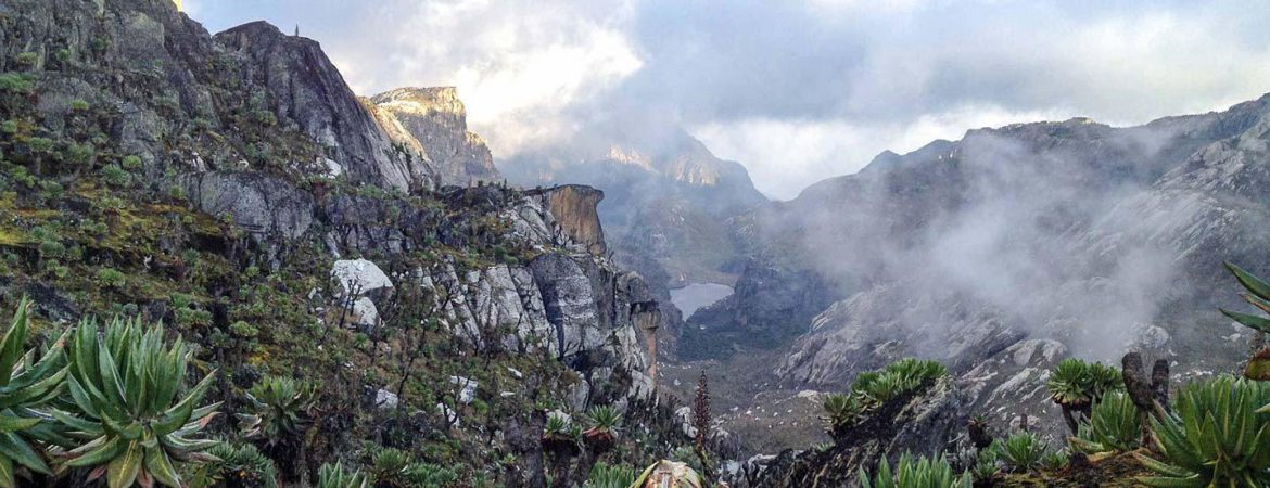
From the trail, the views looking south open to reveal the towering massifs of Mount Stanley, Mount Speke, and Mount Baker in one panoramic sweep the three highest points in the Rwenzori, forming an imposing triple-headed skyline. Bigo Camp is one of the most atmospheric sites on the Central Circuit, set in the broad, flat Bigo Valley with the peaks rising dramatically on three sides.
Day 8: Bigo Camp (3,505 m) to Bujuku Camp (3,977 m)
| Elevation | Distance | Hiking Time | Accommodation |
| 3,977 m | 6 km | 4-6 hours | Bujuku Hut |
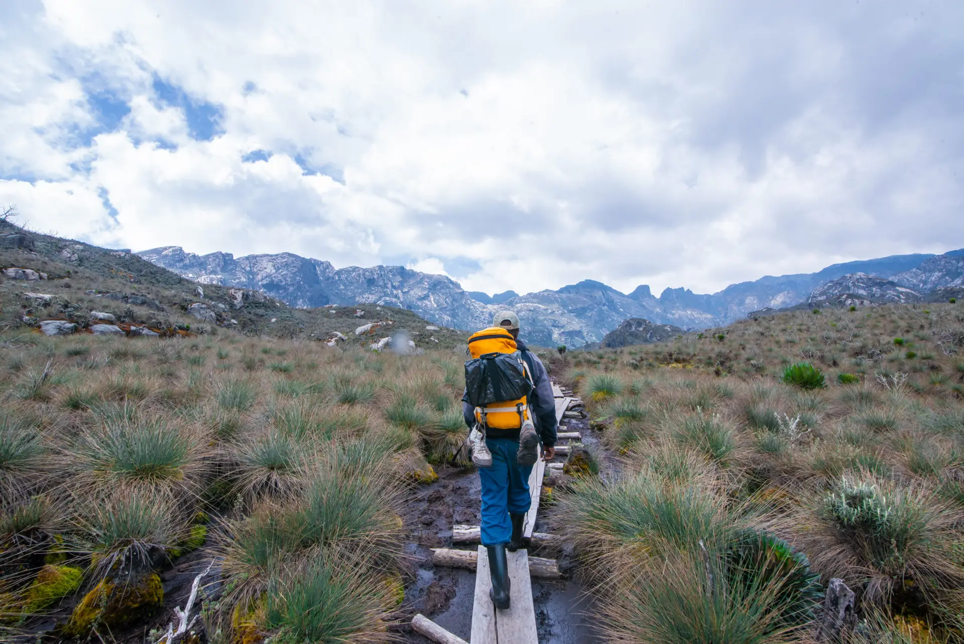
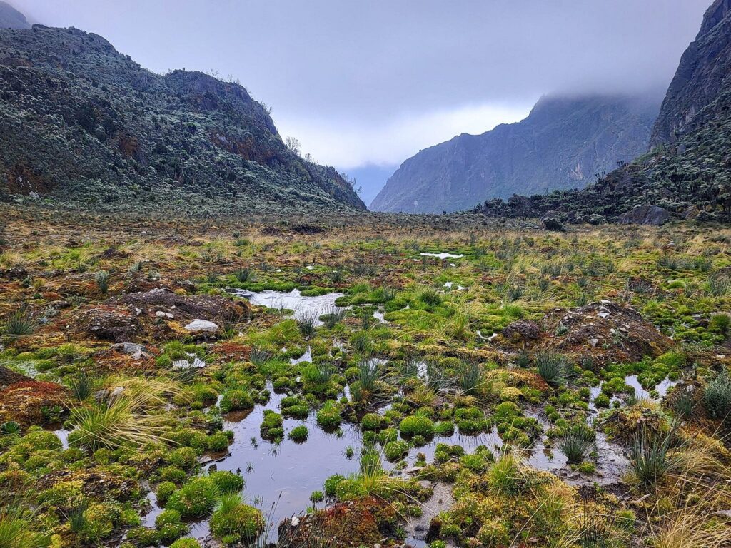
From Bigo Camp, the trail crosses the famous Bigo Bog, a vast, waterlogged plateau at around 3,500 metres, which is one of the most iconic and challenging sections of the entire Central Circuit. The bog is navigated via a series of wooden boardwalks and stepping-stone paths, but significant sections require wading through knee-deep peat and water. This is why the Rwenzori issues rubber boots as standard equipment, and it is a section that even experienced mountain trekkers consistently describe as one of the most uniquely challenging they have encountered anywhere.
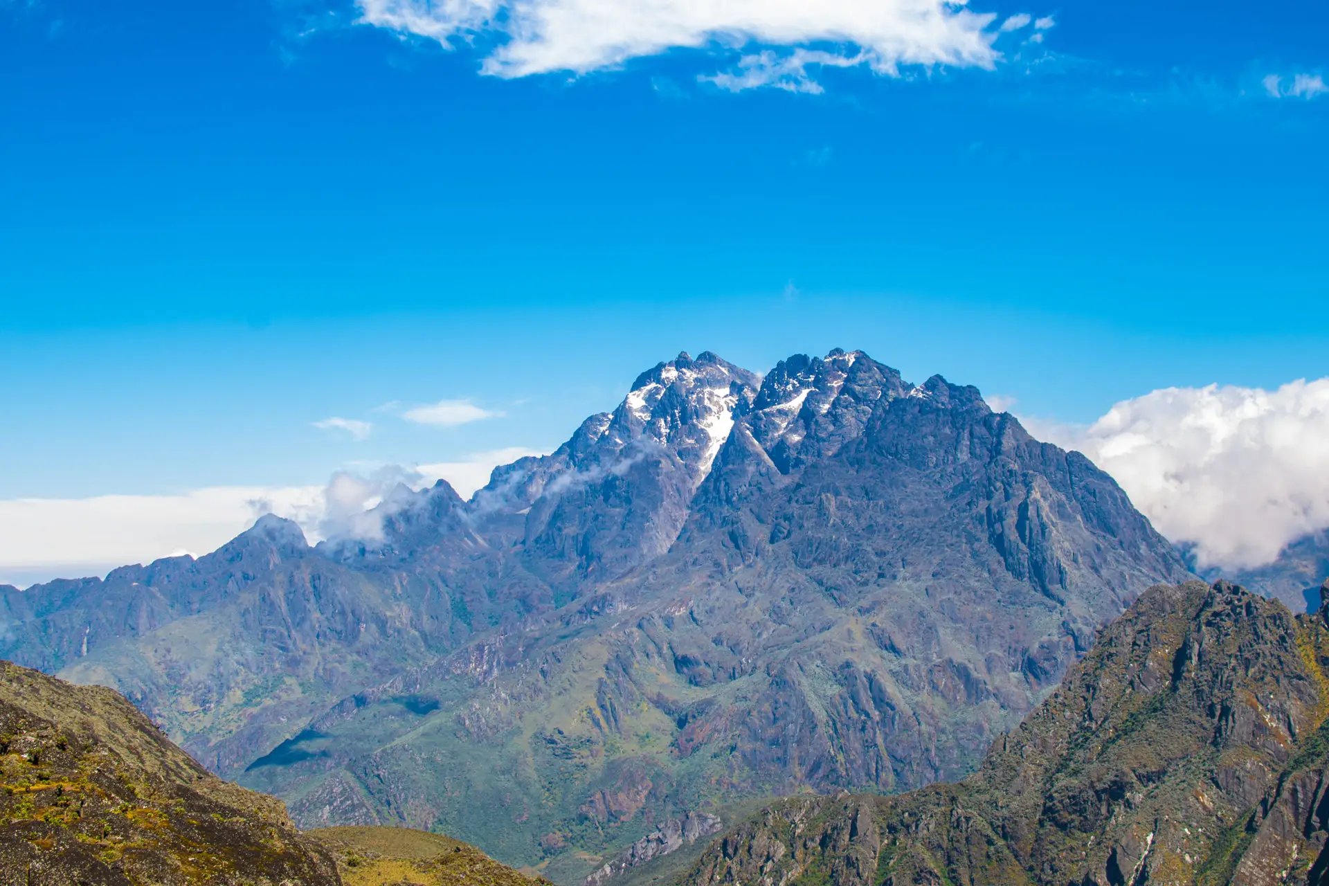
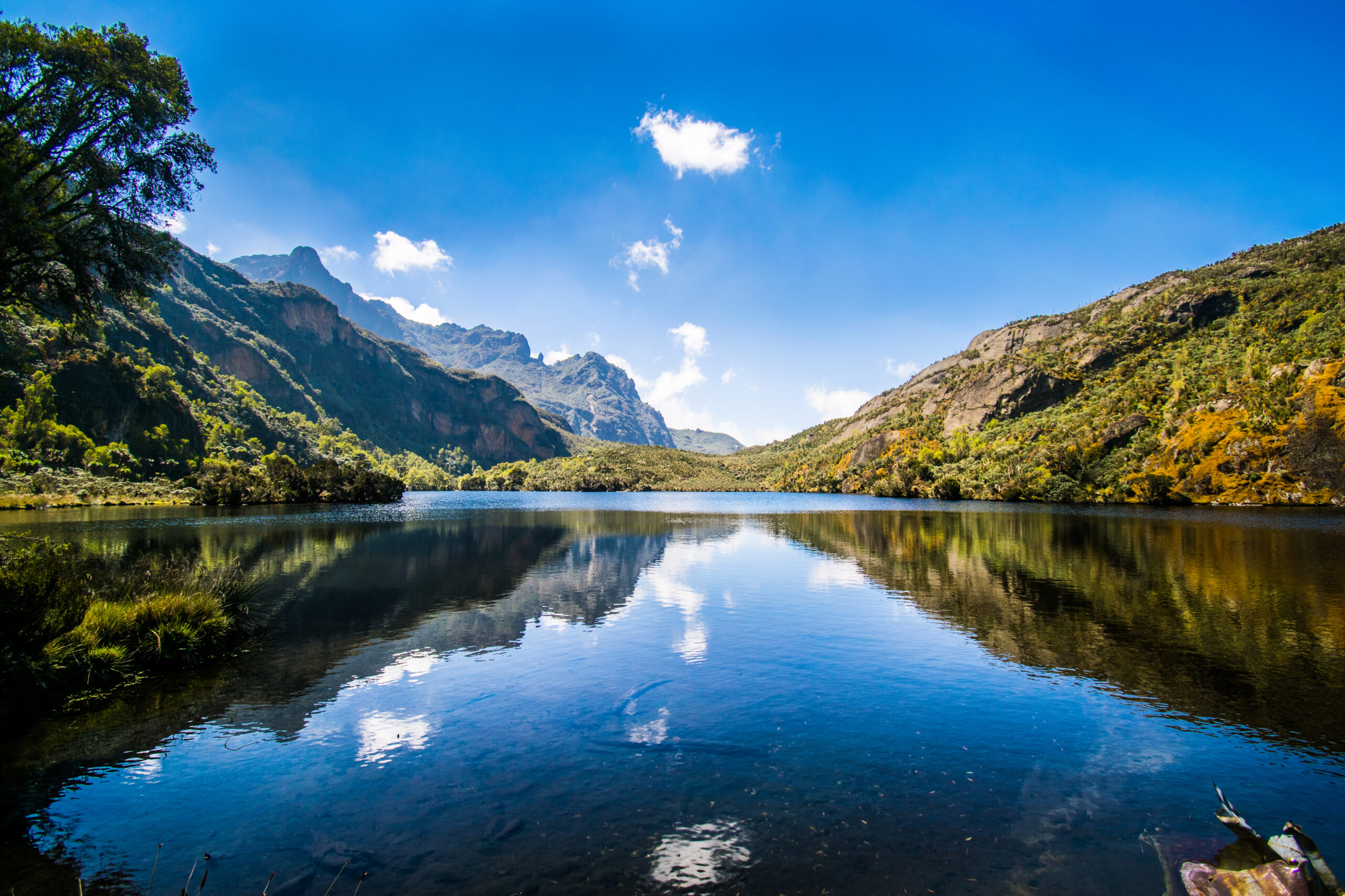
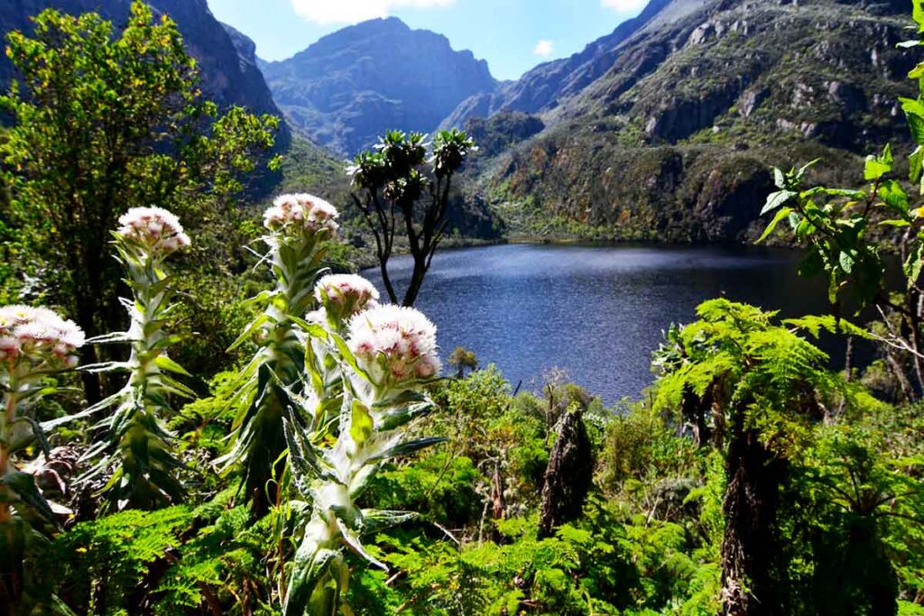
Beyond the bog, the trail climbs steadily past Lake Bujuku, a glacial lake at 3,977 metres with extraordinary high-altitude serenity, and up into Bujuku Camp, which sits at the foot of the three towering massifs. Bujuku is often described as the emotional heart of the Central Circuit, positioned as it is beneath the converging faces of Stanley, Speke, and Baker.
The view from Bujuku Camp, looking southeast, is one of the finest mountain vistas in Africa. Cloud permitting, you can see the glaciated upper ridges of Mount Stanley glowing pink in the evening alpenglow. Tomorrow you climb Speke. Tonight you rest and prepare.
Flora Feature: The Bigo Bog & Bujuku ValleyThe Bujuku Valley between Bigo and Elena represents the peak botanical richness of the Rwenzori. Giant lobelias (Lobelia wollastonii) reach extraordinary sizes here, some over 4 m tall. Giant groundsels cluster in groves across the valley floor. This is one of the most botanically unusual high-altitude environments on Earth. See our vegetation zones guide for a full breakdown of the five ecozones you cross on this expedition. |
Day 9: Summit Mount Speke (4,890 m) Return to Bujuku Camp
| Elevation | Distance | Hiking Time | Accommodation |
| 4,890m summit | 8-10 km return | 7-9 hours | Bujuku Hut |
This is the third summit of the expedition, and at 4,890 metres, it is the highest point you will have reached since arriving on the mountain. Climbers reach Mount Speke’s principal summit, Vittorio Emanuele Peak, via Stuhlmann Pass and a demanding rocky ridge. The ascent route crosses some of the most spectacular high-altitude terrain on the entire circuit, with sheer rock faces, snow patches, and sweeping views developing as you gain elevation.
The route to Speke’s summit begins with a steep climb from Bujuku Camp into the boulder field above the valley. Dr. Stuhlmann’s Pass, named after the German explorer Franz Stuhlmann, who first surveyed this area in 1891, provides the key between Bujuku Valley and the upper Speke massif. From the pass, the final approach to the summit involves confident scrambling over solid rock.
From Vittorio Emanuele Peak at 4,890 metres, the panoramic view on a clear day encompasses virtually the entire Rwenzori massif. Mount Stanley’s ice-capped summit towers to the southwest. The Congo escarpment drops away to the west. Looking east on clear days, the plains of Uganda extend to the distant horizon. This vista is one of the great viewpoints in East Africa.
Summit 3 of 6: Mount Speke, 4,890 m (Vittorio Emanuele Peak)You are now above 4,800m and significantly beyond the altitude acclimatization threshold. Monitor yourself and your group for AMS symptoms at all times. Your guide carries supplemental oxygen and emergency evacuation equipment. |
Day 10: Bujuku Camp (3,977 m) to Elena Camp (4,541 m)
| Elevation | Distance | Hiking Time | Accommodation |
| 4,541 m | 4 km | 4-6 hours | Elena Hut |
A shorter but intensely demanding day both in terms of elevation gain and technical terrain. From Bujuku Camp, the trail crosses the lower Bujuku bog once more before beginning a sustained ascent towards Scott Elliot Pass (4,372 m), the high col between the Bujuku and Kitandara valleys. The bog crossing here involves navigating through thick tussock grass and seasonal streams. Progress is slow, but the views are exceptional.
The final section from Scott Elliot Pass to Elena Camp climbs past boulder fields and groundsel groves in thin air, gaining a further 170 metres to reach the hut at 4,541 metres. Elena Camp is the highest permanent sleeping structure on the mountain, a simple but solid hut positioned directly beneath the glaciated upper slopes of Mount Stanley. Here, the glacier’s proximity immediately and powerfully affects you.
The evening at Elena Camp carries a particular weight. Tomorrow morning you will be on the Stanley Glacier before dawn. Ensure all glacier equipment, crampons, ice axe, and harness are correctly fitted and functioning. Dinner is early. Lights out by 7:30pm. Your guide will wake the group at 2:30-3:00 am.
Pre-Summit Preparation: Elena Camp Evening BriefingYour guide will conduct a full glacier equipment briefing at Elena this evening. The course will cover crampon technique, rope procedure, glacier hazard awareness, and turnaround protocols. Ask every question you have tonight, not in the glacier tomorrow morning. |
Day 11: Summit Margherita Peak (5,109 m), Descent to Kitandara Camp (4,023 m)
| Elevation | Distance | Hiking Time | Accommodation |
| 5,109 m summit | 12-14 km | 10-13 hours | Kitandara Hut |
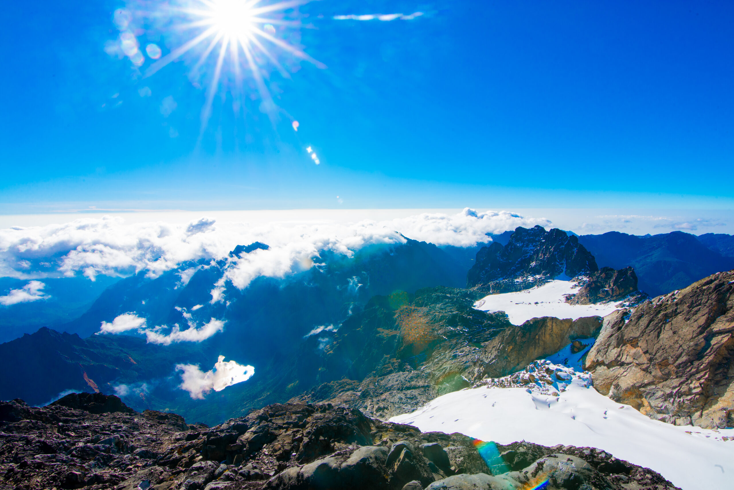
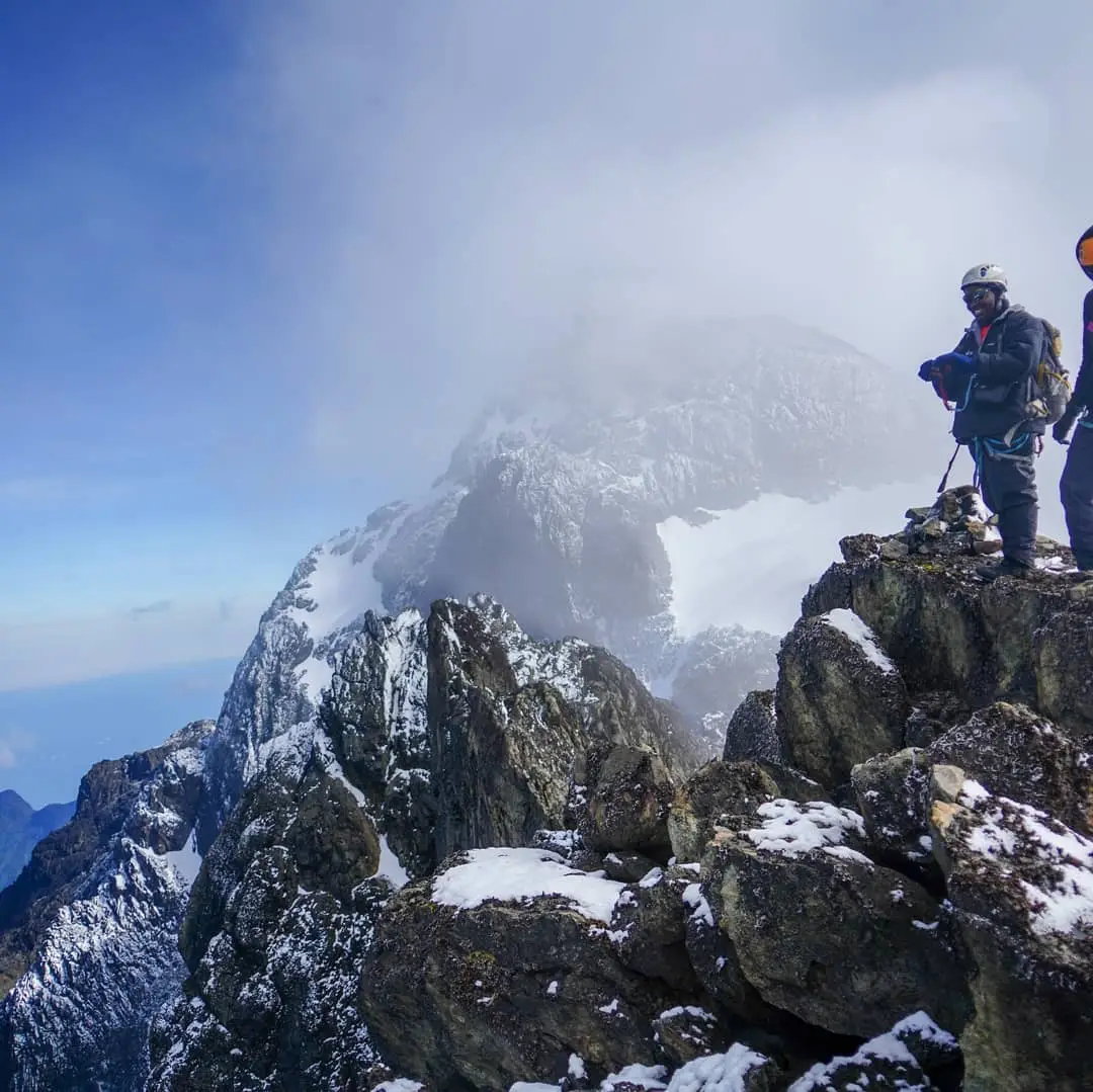
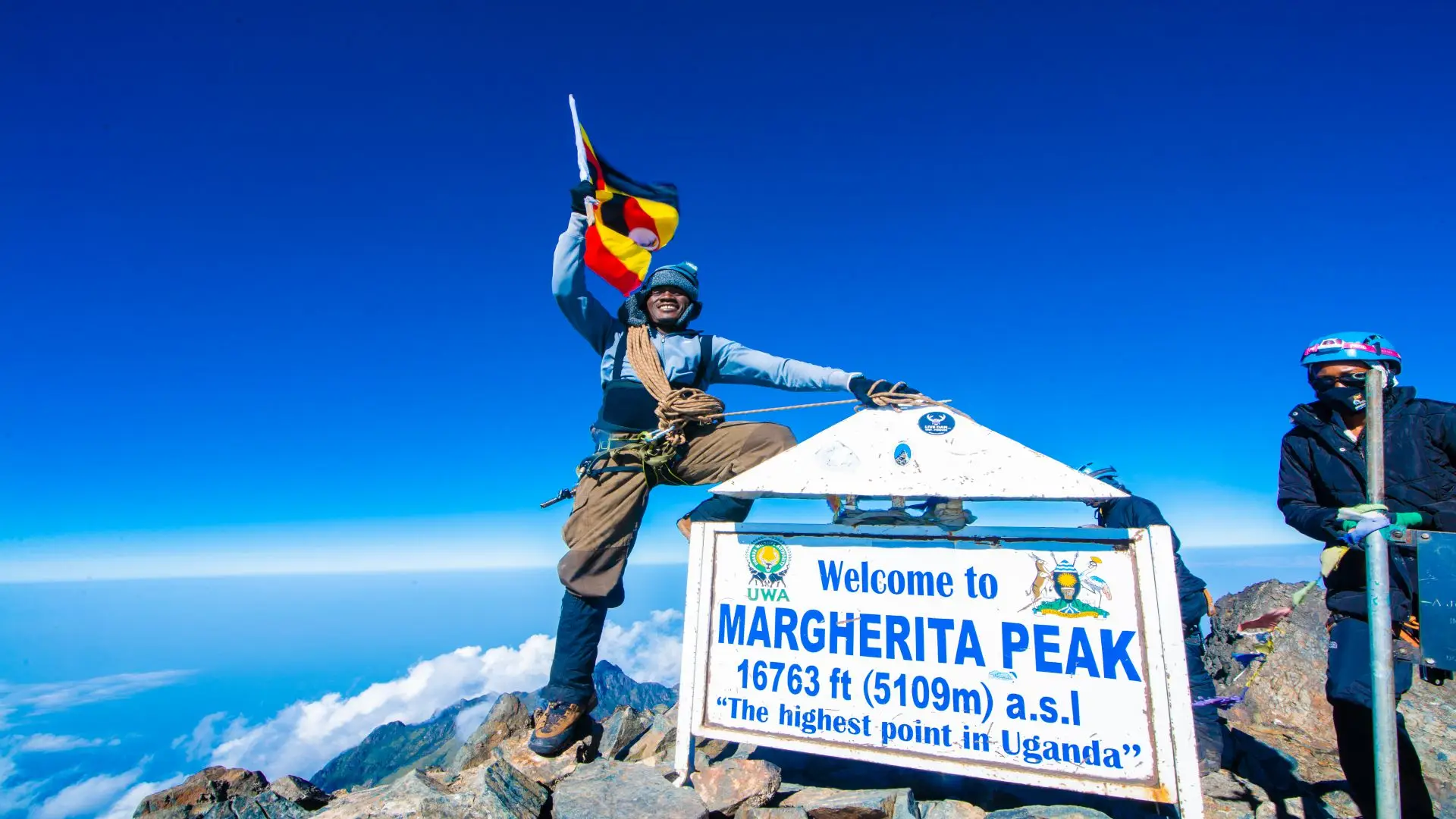
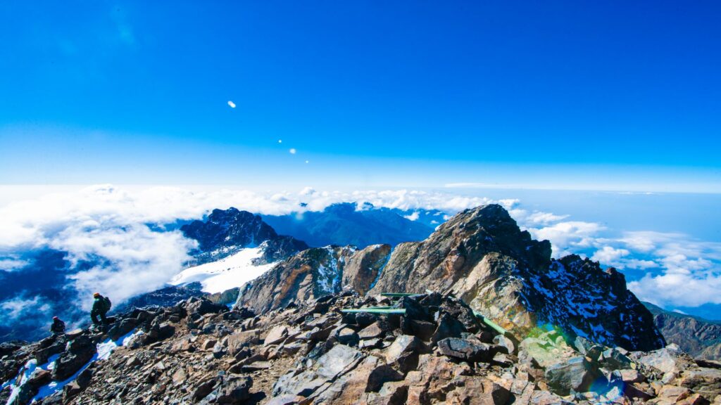
The centerpiece of the entire expedition. The summit of Margherita Peak at 5,109 metres on Mount Stanley, Africa’s third-highest point, is one of the most extraordinary and hard-earned summits on the continent. Reaching it requires crossing permanent glacial ice at the equator, a fact that still astonishes even experienced mountaineers who stand on it.
Your alarm sounds at 2:30-3:00am. Breakfast consists of brief hot porridge, tea, and energy bars. The departure from Elena Hut is made with a headlamp in the dead of high-altitude nights. The first section crosses the boulder field directly behind the hut before the trail reaches the edge of the Stanley Plateau, the large snowfield and glacier system that surrounds the summit massif.
Crampons are fitted at the glacier edge. Roped together under your guide’s leadership, the team moves steadily across the ice in the pre-dawn darkness. The glacier groans occasionally beneath your feet. The stars over equatorial Africa at 4,800 metres on a clear night are beyond description.
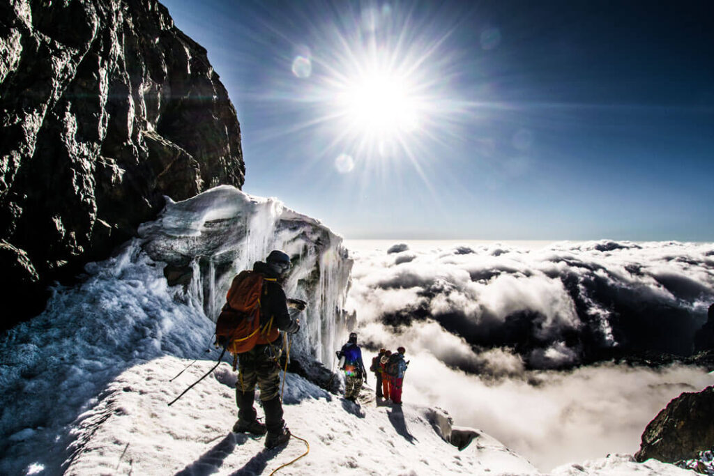
As the eastern horizon begins to lighten, you approach the final rocky section below Margherita’s summit ridge. The last 100 metres involve steep climbing on mixed rock and ice, making it the most technically demanding section of the entire expedition. And then you are there. On Margherita Peak. Africa below you. The sun is rising over Uganda. Ice crystals in your beard or hair. Six of you are standing on the third-highest summit on the continent.
After photographs and a summit stay of 20-30 minutes, the descent begins. Back down the glacier, crampons off at the moraine, and then the long but beautiful traverse across Freshfield Pass and down into the Kitandara Lakes valley, one of the most scenic descents in the Rwenzori. The twin Kitandara Lakes, at 4,023 metres, are a magical arrival point after one of the longest days of your trekking life.
Summit 4 of 6: Margherita Peak, 5,109 m (Africa’s 3rd Highest Point)Technical equipment provided: crampons, ice axe, helmet, harness, and fixed ropes on the glacier section. All glacier equipment is included in your expedition package. Read our summit success rate data for context on conditions and preparation factors. |
Day 12: Summit Mount Baker (4,843 m) via Freshfield Pass, Camp at Freshfield Pass (4,282 m)
| Elevation | Distance | Hiking Time | Accommodation |
| 4,843 m summit | 9-11 km | 7-9 hours | Freshfield Pass Camp |
The fifth summit. Mount Baker, at 4,843 metres is reached by ascending northeast from Kitandara Camp across the moraine above the lakes and up to Freshfield Pass at 4,282 metres. The pass itself is a dramatic saddle of exposed rock and heather, with the Baker massif rising above to the east and the Kitandara valley falling away to the west.
The approach to Baker’s summit, Edward Peak, from Freshfield Pass involves steep scrambling on large metamorphic blocks. The rock here is ancient, solid, and offers good purchase even in damp conditions. The final metres to the summit involve a short but exposed ridge traverse with vertical drops on both sides. Your guide will rope the group here if conditions warrant.
The summit views from Mount Baker are among the finest in the range. The Kitandara Lakes below shimmer in the sunlight. Margherita Peak, which you stood on just yesterday, is visible to the northwest. Mount Speke rises to the north. This is the last great viewing platform of the expedition before the descent begins in earnest.
You camp tonight at Freshfield Pass, a wild camp on the windward side of the pass with broad exposure to the valley systems below. The sunsets from Freshfield Pass, when cloud permits, are spectacular.
Summit 5 of 6: Mount Baker, 4,843m (Edward Peak)Five peaks down, one to go. You are now in the final stretch of the expedition. Rest well at Freshfield Pass; tomorrow is another early start for Weismann Peak before the long descent to Nyakalengija. |
Day 13: Summit Weismann Peak (4,627 m), Descent to Nyakalengija (1,650 m)
| Elevation | Distance | Hiking Time | Accommodation |
| 4,627 m summit | 18-22 km | 11-13 hours | Nyakalengija Gate |
The final day. This is the sixth and last summit. Weismann Peak is the highest point of Mount Luigi di Savoia at 4,627 metres and is reached by continuing the traverse from Freshfield Pass east along the high ridge above the Mubuku Valley. The ascent to Weismann Peak is technically less demanding than the previous two summits, a steep but well-defined scramble over rock and heather to the exposed summit cairn.
Stand on Weismann Peak and count them in your memory: Gessi, Emin, Speke, Margherita, and Baker. And now this one. All six of the Rwenzori’s major massifs. Take your photographs. Let the reality settle in. You have completed one of the most comprehensive mountain expeditions in East Africa.
The descent from Weismann Peak returns to Freshfield Pass and then follows the Mubuku Valley trail north through Guy Yeoman Camp and the bamboo zone, reconnecting with the outbound route above Nyabitaba. The final section descends through the dense montane forest to Nyakalengija Gate, where the trail began 13 days ago. The forest feels different on the way out, or perhaps you do.
Arrive at Nyakalengija Gate in the late afternoon, where certificates of completion are awarded. For trekkers staying in Kasese, transport can be arranged back to town (30 minutes). For those with onward travel, our team can assist with logistics and transfers.
Summit 6 of 6: Weismann Peak, 4,627 m (Mount Luigi di Savoia)Expedition complete. Six peaks. Thirteen days. Africa’s Mountains of the Moon are fully visible. |
Elevation Profile: 13-Day Expedition Arc
The elevation story of this expedition is one of sustained high-altitude immersion, punctuated by six summit pushes. Understanding the arc helps you plan your acclimatization and energy management across the 13 days.
The first two days are pure ascent from 1,650 metres at Nyakalengija to 3,505 metres at John Matte, gaining the bulk of the baseline altitude. Days 3 and 4 continue the ascent to the Lac de la Luna base at approximately 4,100 metres. Days 5 and 6 are summit-and-return days, with the expedition moving between 4,100 and 4,715-4,798 metres. Day 7 descends back to the 3,505-meter Bigo valley before Day 8 re-ascends to 3,977 metres at Bujuku.
Day 9 spikes to its highest point yet at 4,890 metres on Speke before returning to Bujuku. Day 10 climbs to the expedition’s pre-summit high camp at 4,541 metres (Elena). Day 11 represents the apex of the entire expedition at 5,109 metres on Margherita, followed by a significant descent to 4,023 metres at Kitandara. Days 12 and 13 conclude the summit sequence with Baker (4,843m) and Weismann (4,627m) before the sustained descent to Nyakalengija.
The expedition spends approximately 7 of its 13 days above 3,500 metres, including 5 nights above 3,900 metres. This sustained high-altitude exposure makes acclimatization planning and prior altitude experience critically important.
Camps & Accommodation on the 13-Day Expedition
Nyabitaba Camp (2,652 m)
A substantial wooden hut set on a forested ridge with bunk sleeping for groups of up to 20 trekkers. Communal dining area, separate kitchen, and an outdoor veranda with views of the Portal Peaks. This facility is the best-appointed camp on the lower mountain. Water from a nearby stream. Drop-off toilets nearby.
John Matte Camp (3,505 m)
A solid multi-room hut at the base of the Bujuku Valley ascent. Bunk sleeping, communal dining, and a small cooking shelter. The views from the camp, looking towards the upper massifs, are exceptional on clear evenings. Water from a stream above the camp. Drop toilets were provided.
Skull Cave Camp (~3,950 m)
A natural rock overhang used as a sheltered camping site above the heather zone. Ground tents pitched on the flat ground beneath and around the cave structure. No hut facilities; this is wild camping. Water sourced from nearby streams. A raw, spectacular camp that many trekkers remember as their favorite on the entire circuit.
Lac de la Luna (~4,100 m)
A glacial lake camp used as a two-night base for the Gessi and Emin summit days. Ground tents pitched on the lake margin in sheltered spots. The lake’s mirror surface on calm mornings reflects the surrounding rocky peaks. The weather is cold and frequently cloudy, but it has a deeply atmospheric quality. Water from the lake (treated).
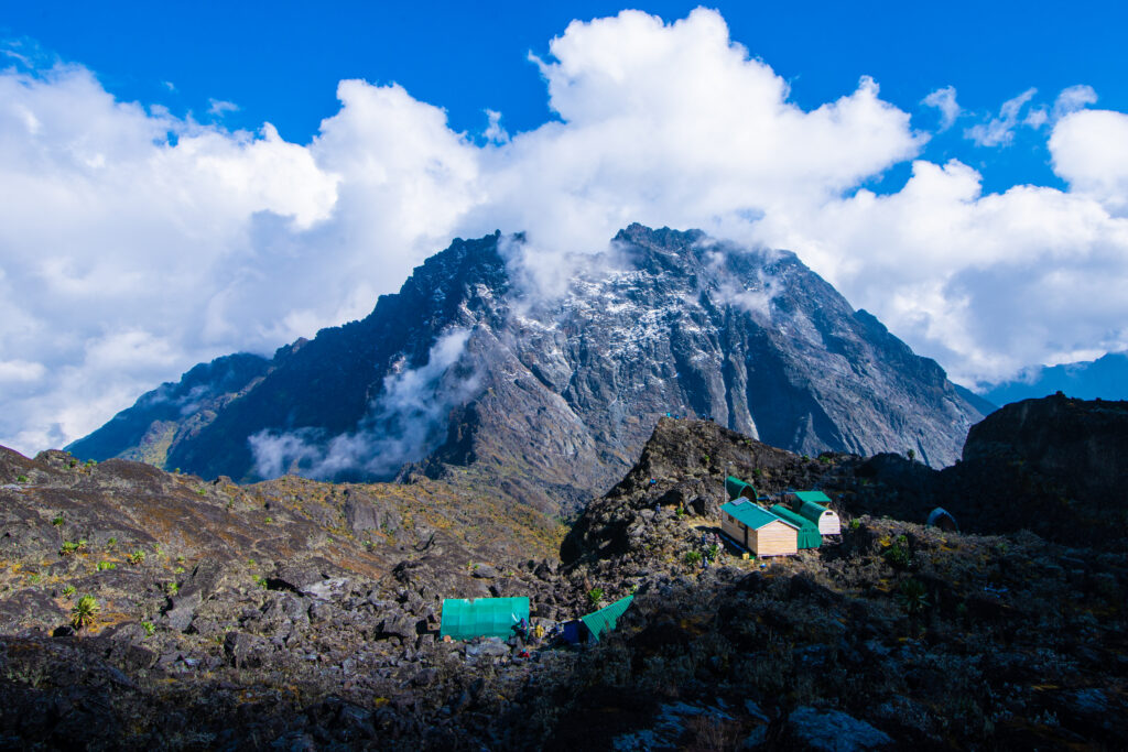
Bigo Camp (3,505 m)
A hut camp set at the edge of the famous Bigo Bog in the central Rwenzori plateau. Solid bunk hut with a communal dining area. The position in the flat-bottomed valley imparts Bigo a particularly moody, mist-shrouded quality. Water from a stream nearby. Drop toilets were provided.
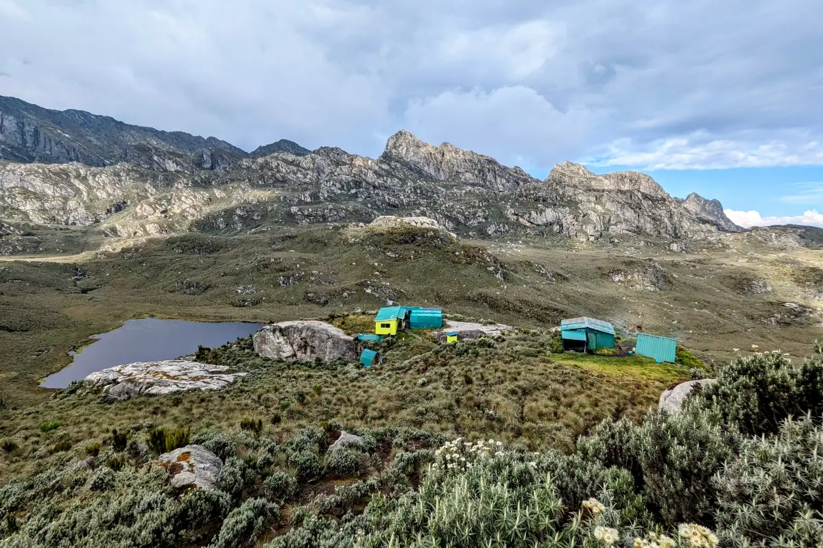
Bujuku Camp (3,977 m)
The emotional heart of the Central Circuit. A well-maintained hut camp directly beneath the triple massifs of Stanley, Speke, and Baker. Bunk sleeping, communal dining, and the finest position of any camp on the mountain. The sunrise view from Bujuku across the frozen upper peaks is one of the defining images of Rwenzori trekking.
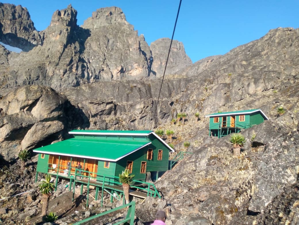
Elena Camp (4,541 m)
The highest permanent sleeping structure in the Rwenzori. A simple but solid single-room hut with basic bunks for approximately 12 trekkers. Cold, exposed, and positioned directly at the glacier edge. The remoteness and altitude make Elena Camp a truly memorable mountain experience. No luxury, just the raw reality of being at the threshold of Africa’s highest glaciers.
Kitandara Camp (4,023 m)
A two-lake camp in one of the Rwenzori’s most scenic valleys. Solid hut with bunk sleeping and communal dining. The Lower Kitandara Lake is immediately adjacent to its still water, and the surrounding rocky peaks create a genuinely beautiful mountain environment. A wonderful recovery camp after the demanding Margherita summit day.
Freshfield Pass Camp (~4,282 m)
A wild camp at the high pass connecting the Kitandara and Mubuku valleys. Ground tents in exposed but dramatic surroundings. Cold and windy but positioned for incredible views in clear conditions. Water sourced from snowmelt streams.
Flora & Wildlife to Expect on the 13-Day Expedition
The Rwenzori’s five distinct vegetation zones are all traversed on this expedition, making it the most botanically comprehensive route available. Each zone reveals a dramatically different ecological character, from the lowland forest at Nyakalengija to the glacial rock at Margherita.

The montane forest zone (1,650-2,500 m) is rich in Podocarpus and Symphonia trees, home to the Rwenzori turaco, olive sunbird, and black-and-white casqued hornbill. Primates are occasionally heard here, particularly chimpanzees in the lower forest margins. The bamboo zone (2,500-3,000 m) is a dense, cool belt supporting the Rwenzori red duiker and numerous forest floor invertebrates. This zone is often obscured in mist and has a uniquely prehistoric quality.
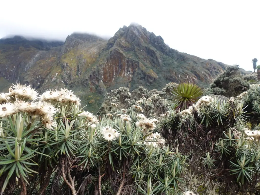
The hagenia-hypericum zone (3,000-3,500 m), the “mossy forest,” is the most atmospheric section of the lower mountain, draped in old man’s beard lichen and carpeted in thick Sphagnum moss. Giant heather trees (Erica arborea) can grow to 10 metres or more. The heather zone (3,500-4,500m) transitions into the true Afroalpine environment, with giant lobelias and giant groundsels (Dendrosenecio) becoming dominant. These plants, found only on the highest African peaks, are the Rwenzori’s botanical signature.
Above 4,500 metres, the rock desert and glacier zone supports only the hardiest life: lichens, mosses, and a few specialist insects. At night, you may spot the Rwenzori mouse near camps at this altitude. Throughout the expedition, the Rwenzori turaco, Lagden’s bush-shrike, and the Rwenzori nightjar are likely avian encounters on the middle mountain.
Physical Difficulty & Fitness Requirements
This expedition is rated Very Strenuous and is suitable only for experienced trekkers with prior high-altitude mountain experience. Read our honest Rwenzori difficulty guide for a full breakdown of what the mountain demands.
The 13-Day 6 Peaks Expedition is harder than a standard Kilimanjaro climb in every measurable dimension. The daily terrain is technically more demanding, the weather is wetter and less predictable, the cumulative elevation exposure is greater, and the total summits attempted are six rather than one. You should not attempt this expedition as your first multi-day mountain trek.
Minimum requirements for this expedition: prior multi-day trekking experience at altitude (above 3,500m), good cardiovascular fitness with a training program of at least 4-6 months, experience with cold and wet mountain conditions, and physical strength sufficient for sustained scrambling on rocky terrain. Prior glacier experience is not required; full technical training and equipment are provided, but comfort with exposure and heights is important.
For fitness training guidance specific to this expedition, see our Rwenzori fitness and training guide. For questions about whether your specific health conditions are compatible with this altitude, consult our complete medical guide and speak with your GP before booking.
The sustained time above 4,000 metres on this expedition is the most significant altitude challenge. The itinerary structure partly manages acclimatization, and the two-night Lac de la Luna base camp before the Gessi/Emin summits provides important adaptation time. However, people respond to altitude in significantly different ways. Our guides monitor all trekkers throughout and can modify pace, schedule additional rest days, or initiate descent protocols as required.
Is This Expedition Right for You?Ideal candidates: experienced trekkers who have completed Kilimanjaro, Mont Blanc, or similar multi-day mountain routes; trekkers with prior experience above 4,000m; those with 6+ months of dedicated pre-expedition training. If you have completed the 7-day Rwenzori trek and want the full experience, the 13-day 6 Peaks Expedition is your natural next step. |
Best Time to Do the 13-Day 6 Peaks Expedition
The Rwenzori are technically open all year, but the two primary dry seasons offer significantly better trekking conditions. Full seasonal analysis is available in our best time to visit the Rwenzori guide.
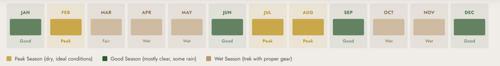
December to March (primary dry season): The most reliable dry window for a 13-day expedition. Temperatures on the high mountain are cold but manageable, trail conditions are comparatively firm, and glacier crossings are in their best condition. Summit success rates are highest during this period.
June to August (secondary dry season): This is the second recommended window. The period is slightly less stable than the December-March period, but it is still significantly better than the wet seasons. June and July can see clearer skies and excellent summit views. August is transitional and can bring unpredictable weather.
March to May and September to November (wet seasons): The Rwenzori receives some of the highest annual rainfall of any mountain in Africa, significantly more than Kilimanjaro or Mount Kenya. The wet season is genuinely challenging: trails become dangerously muddy, river crossings can be unsafe, and cloud cover often obscures summit views. Experienced trekkers who specifically enjoy raw, challenging mountain conditions may appreciate the wet season’s intensity. For the 13-day expedition with six summit objectives, however, the dry seasons are strongly recommended.
What’s Included in the 13-Day Expedition Package
Included
- Professionally certified Rwenzori mountain guides for the full 13 days
- Porters to carry expedition equipment and supplies (1 porter per trekker)
- All meals on the mountain (breakfast, lunch, and dinner) prepared by a mountain cook
- Accommodation in mountain huts where available; tents for wild camp nights
- Full technical summit equipment: crampons, ice axes, helmets, harnesses, and fixed ropes for glacier crossing
- Free use of rubber boots for the duration of the trek
- Uganda Wildlife Authority (UWA) park entry fees and trekking permits
- Guide, porter, and rescue team fees
- Summit certificate upon completion
- Emergency first aid kit and oxygen carried by guides
Not Included
- Tips and gratuities for guides and porters (recommended: USD 15-20/day for guides, USD 10-12/day for porters)
- Personal trekking gear (sleeping bag, trekking poles, clothing layers see packing list)
- Travel and medical evacuation insurance (mandatory; see insurance guide)
- Accommodation before and after the trek (Kasese and Fort Portal options available)
- Transfers to/from Nyakalengija trailhead (can be arranged on request)
- Personal medical expenses or medications
- Alcoholic beverages
- Flights to/from Uganda
Complete Packing & Gear List for the 13-Day 6 Peaks Expedition
You can find the full detailed packing list with brand recommendations and weight guidance in our comprehensive Rwenzori packing guide. The following is the expedition-specific summary for the 13-day, 6- peaks route.
Footwear

Rubber boots are mandatory for the Rwenzori’s bog sections and are provided free of charge. However, you should also carry a pair of sturdy waterproof hiking boots for the rocky summit sections where rubber boots are unsafe. Gaiters are strongly recommended. Read our boot selection guide for the Rwenzori for detailed guidance on the two-boot system.
Sleeping System
Sleeping bag rated to -10C (14F) minimum, given nights at Elena Camp (4,541m) and Freshfield Pass (~4,282m). A sleeping bag liner adds warmth and comfort. Compression bag or waterproof stuff sack is essential; everything gets wet on the Rwenzori.
Clothing Layers
- Base layer (thermal): 2 sets, moisture-wicking merino or synthetic
- Mid layer: fleece or softshell jacket for camp warmth
- Insulating layer: down or synthetic puffy jacket for Elena Camp and summit days
- Hard shell: fully waterproof jacket and trousers critical on the Rwenzori
- Warm hat, balaclava, and sun hat
- Waterproof gloves and liner gloves (two pairs)
- Trekking trousers: 2 pairs, quick-dry
Summit & Technical Gear (Provided by Us)
The expedition package includes crampons, an ice axe, a helmet, a harness, and fixed ropes. You do not need to source or carry these. Personal items to add to the summit pack: hand warmers (highly recommended), warm summit gloves, goggles or glacier glasses, and a warm down layer.
Essential Pack Items
- Headlamp with spare batteries (essential for summit pre-dawn start)
- Trekking poles (collapsible, highly recommended for boggy terrain)
- Waterproof backpack cover or dry bags for all gear
- Refillable water bottles (2 x 1L) and water purification tablets
- Sunscreen SPF50+ and lip balm (intense UV at altitude)
- Personal first aid kit, including blister treatment and pain relief
- Camera or smartphone with waterproof case and power bank
- Snacks and energy bars for summit days (in addition to guide-provided meals)
Permits, Park Fees & Costs
Full cost transparency is a priority for us. Our complete Rwenzori trekking cost guide breaks down every fee in detail. Below is a summary specific to the 13-day expedition.
The all-inclusive expedition price for the 13-Day 6 Peaks route starts at USD 3,200 per person, which includes all park fees, guide fees, porter fees, accommodation, meals, and technical equipment as listed above. The per-person price decreases for larger groups. Private expeditions can be arranged with custom start dates.
Uganda Wildlife Authority (UWA) park entry fees are included: USD 50 per day for non-residents (13 days = USD 650 included in your package). Guide and porter fees, hut fees, and rescue fund contributions are all incorporated. The only significant additional cost you will incur is tipping, which is entirely discretionary but culturally important for the local guide and porter community. Our porter and tipping guide provides recommended daily rates and total tipping budgets for reference.
For trekkers considering this expedition as part of a broader Uganda trip, our 12-Day Rwenzori and Gorilla Trek combination and 16-Day Uganda Gorillas and Rwenzori package offer excellent pre- or post-expedition additions.
Getting to the Rwenzori: Transport & Logistics
Full logistics guidance is available in our how-to-get-to-the-Rwenzori guide. Below is a practical summary for 13-day expedition planning.
You can find the Rwenzori Mountains National Park entrance gate at Nyakalengija 22 kilometers from Kasese town in western Uganda. Kasese is the gateway town for all Rwenzori expeditions. We recommend arriving in Kasese at least one day before your expedition start date to rest, confirm equipment, and meet your guide team.
From Entebbe International Airport: road transfer approximately 6-7 hours by private vehicle, or take an internal flight from Entebbe to Kasese Airport (approximately 1 hour). Both transfer options can be arranged through our office.
From Kampala: approximately 5–6 hours by private vehicle via the Kampala-Kasese Highway. Bus services (Link buses) run daily from Kampala to Kasese and are a budget-friendly option. However, for expedition trekkers with significant gear, a private transfer is recommended.
For accommodation the night before and after your expedition, our Kasese gateway guide and pre- and post-trek accommodation guide cover all options from budget guesthouses to the Rwenzori Trekkers Hotel adjacent to the park gate.
Book Your Trek
Respond within Minutes
From
$3,350
per person
- Duration 13 Days / 12 Nights
- Group Size 1–12 people
- Start Point Nyakalengija
- Departures Year-round
- Summits Gessi, Emin, Speke, Margherita, Edward & Weismann Peaks
No booking fee. Free cancellation up to 30 days before departure. We respond within Minutes.
Our Popular Rwenzori Treks
Magheritah Peak (8 Days Kilembe Trail)
$1705 Per Person
Mutinda LookOut (4 Days)
$645 Per Person
Short Magherita Hike (5 Days Central Circuit)
$1200 Per Person
Rwenzori Hike (7 Days Central Circuit)
$1400 Per Person
Frequently Asked Questions: 13-Day Rwenzori 6 Peaks Expedition
How difficult is the 13-Day Rwenzori 6 Peaks Expedition compared to Kilimanjaro?
The 13-Day Rwenzori 6 Peaks Expedition is significantly harder than a standard Kilimanjaro trek in every dimension. The daily terrain is technically more demanding, involving dense bog crossings, rocky scrambles, and glacier travel. The weather is consistently wetter and more unpredictable. The expedition involves six separate summit ascents above 4,600m, compared to one on Kilimanjaro. Cumulative distance, elevation gain, and days above 4,000m are all greater on this expedition. Trekkers who have completed Kilimanjaro without difficulty can attempt this expedition with appropriate additional training.
Do I need prior glacier experience to summit Margherita Peak?
No prior glacier experience is required for this expedition. Our certified mountain guides provide complete training in crampon technique, ice axe use, and rope protocol at Elena Camp the evening before the summit attempt. The expedition package includes all technical equipment, crampons, ice axe, helmet, harness, and ropes. What is required is physical confidence, a calm head for exposure, and trust in your guide’s instructions. The glacier section on the Stanley Plateau is steep but navigable with guide support.
What is the success rate for summiting all six peaks on this expedition?
The summit success rate across all six peaks varies by individual fitness level and weather conditions, but experienced trekkers in good physical condition who have prepared properly have a high completion rate. Margherita Peak (5,109m) has the lowest individual success rate of the six summits due to altitude and glacier conditions, but our guided expedition format significantly improves outcomes. The most common reason for a partial completion is altitude sickness on the upper mountain, which is why prior altitude experience and proper acclimatization during the expedition are so important.
Is technical climbing experience required for any summit on the 13-day expedition?
Technical rock climbing experience is not required for any of the six summits on this expedition. Gessi, Emin, Baker, Speke, and Weismann are all achieved via scrambling and steep hiking on rocks. Margherita Peak requires glacier travel with crampons and an ice axe. Our guides provide this equipment and all necessary training. However, all six summits require physical confidence on exposed, steep terrain and the ability to follow guide instructions precisely. Trekkers who are uncomfortable with heights or exposure may find some summit ridges challenging.
What happens if I get altitude sickness on the expedition?
We take altitude sickness management extremely seriously on all our expeditions. Every guide carries supplemental oxygen, a pulse oximeter, and emergency medication. If a trekker shows signs of acute mountain sickness (AMS), our protocol is to rest and monitor at the current camp level; if symptoms worsen, descent is immediate and non-negotiable. The Rwenzori’s route structure means that descent to a lower altitude is always possible within a few hours. Medical evacuation from the mountain is coordinated with the Uganda Wildlife Authority rescue services. We strongly recommend all trekkers carry comprehensive travel and evacuation insurance.
What should I eat and drink on the mountain to maintain energy across 13 days?
Your mountain cook prepares three hot meals per day using locally sourced ingredients supplemented by expedition food stocks. Breakfasts are typically porridge, eggs, toast, and hot drinks. Lunches are packed lunches carried on the trail: sandwiches, fruit, nuts, and energy bars. Dinners are hot, substantial meals: soups, stews, rice, pasta, and protein. The caloric demands of this expedition are very high; you should expect to burn 3,500-4,500 calories per day on summit days. We recommend supplementing cook-prepared meals with your own personal snacks and energy gels on summit days. Stay well hydrated throughout; water is sourced from mountain streams and treated by your cook team.
Can I do the 13-Day 6 Peaks Expedition as a solo trekker?
Solo trekking without guides is not permitted in the Rwenzori Mountains National Park by Uganda Wildlife Authority regulations. However, as an individual trekker, you can absolutely join the expedition as a solo traveler; our team will assign you to a compatible group departure or, for private departures, provide a complete guide and porter team for just you. Solo travelers who book with us are never trekking alone on the mountain; you will always have certified guides and a support team throughout the 13 days.
How many people typically join a 13-Day 6 Peaks Expedition group?
Groups on this expedition typically range from 2 to 8 trekkers. Smaller groups move more efficiently, adapt more easily to variable weather windows, and have a more personalized experience with guides. Larger private groups (up to 12) can be arranged. We do not combine independent bookings into a single large group without consent from all parties. If you prefer to travel with a specific group of friends or colleagues, we can arrange a fully private departure on any agreed date.
How cold does it get on the 13-day expedition?
Temperatures vary significantly by altitude and time of day. At Nyakalengija (1,650 m), daytime temperatures are typically 20-25°C. At John Matte Camp (3,505 m), nights drop to 3-8°C. At Bujuku (3,977 m) and above, night temperatures regularly fall to between 0 and -5°C. At Elena Camp (4,541 m) on summit eve, temperatures can fall to -10°C or below, particularly with wind chill. The Margherita summit at dawn can experience temperatures of -5 to -15 °C with wind. Layering is everything.
Is the 13-Day 6 Peaks Expedition suitable for trekkers over 50?
Age is not a disqualifying factor for this expedition, but physical condition and altitude experience matter enormously. We have successfully guided trekkers in their 50s and 60s on this route. The key requirements are cardiovascular fitness, prior altitude experience, and honest self-assessment of your capability. If you are over 50 and considering this expedition, read our guide for older trekkers on the Rwenzori, consult your doctor, and plan a sustained training program of at least 6 months. A medical clearance letter from your GP is recommended before booking.
What is the difference between this expedition and the 18-Day All 8 Peaks Trek?
The 13-Day 6 Peaks Expedition summits the six major Rwenzori massifs: Gessi, Emin, Speke, Stanley (Margherita), Baker, and Luigi di Savoia (Weismann). The 18-Day All 8 Peaks Expedition includes two additional peaks, the Portal Peaks range, and covers a significantly larger area of the Rwenzori range. The 18-day expedition is the most comprehensive Rwenzori trekking experience available anywhere, incorporating elements of the Kilembe Trail as well as the Central Circuit. For trekkers who want the complete Rwenzori experience without the additional 5 days, the 13-day expedition is the definitive choice.