The Complete Expert Guide to Every Trail in the Mountains of the Moon
Explore all Rwenzori trekking routes: Central Circuit, Kilembe Trail, Bukurungu & Diamond Trail. Expert guide to camps, difficulty, itineraries & summit access. Plan your trek now. There are mountains, and then there are the Rwenzori. Every trekker who has stood at the Nyakalengeji trailhead as morning mist rolls off the Bujuku Valley will tell you the same thing: nothing in their experience of mountain travel has prepared them for what awaits inside. The trails of the Rwenzori Mountains are not simply paths to a summit. They are passages through five of the most dramatic and biologically distinct landscape zones on earth, from cathedral rainforest alive with chimpanzees and L’Hoest’s monkeys, through giant bamboo groves and Tolkienesque heathland draped in old man’s beard lichen, into the otherworldly afro-alpine moorland of three-meter giant lobelias and five-meter groundsels, and ultimately onto glacial ice at the equator. The routes of the Rwenzori Mountains are among the most extraordinary hiking trails in the world. This guide is your definitive resource for planning a journey with them.
Whether you are trying to decide between the Central Circuit Trail and the Kilembe Trail, researching the little-known Bukurungu Wilderness Trail, wondering how many days you need to reach Margherita Peakat 5,109 metres, or simply trying to understand what kind of mountain the Rwenzori actually is, you will find everything you need here. This document is not a summary; it is the guide that every serious Rwenzori researcher needs written by guides who have walked every trail on this range and guided hundreds of expeditions to its summits.
A word on scope: this page covers all four official trekking routes currently operating within Rwenzori Mountains National Park on the Ugandan side of the range. It covers route profiles, camp systems, terrain, vegetation zones, summit access, difficulty, best itineraries, and everything you need to choose the right trail for your objectives and experience level. Read it from beginning to end before you make a decision. The mountain deserves that level of attention.
The Rwenzori Mountains: Understanding the Range Before Choosing a Route
Before examining the individual trails, it is essential to understand the kind of mountain system you are entering. Unlike Africa’s two other great highland ranges, the volcanic Kilimanjaro and the Virunga chain, the Rwenzori is a block mountain system made of ancient Precambrian crystalline rock that has been pushed up along the western branch of the East African Rift System over millions of years. The range stretches approximately 120 kilometers along the Uganda-DRC border, with the Ugandan side protected within Rwenzori Mountains National Park, a UNESCO World Heritage Site covering around 1,000 square kilometers. This geological origin has important consequences for trekkers: the Rwenzori’s routes traverse deeply dissected valleys, steep ridgelines, complex watershed terrain, and a root-and-rock scramble character that is fundamentally different from the broad volcanic flanks of Kilimanjaro.
The range is not one mountain but six distinct massifs, each carrying multiple named summits. At the apex stands Mount Stanley at 5,109 metres, home to Margherita Peak, Uganda’s highest point, and the heavily glaciated Stanley Plateau. Below it in elevation come Mount Speke at 4,890 metres, Mount Baker at 4,843 metres, Mount Emin at 4,798 metres, Mount Gessi at 4,715 metres, and Mount Luigi di Savoia at 4,627 metres. A Rwenzori trekking expedition can target a single peak or, for those with the time and ambition, multiple summits on the same expedition. Knowing which peaks are on which routes is one of the most important pieces of planning intelligence you will need.
The Rwenzori’s equatorial glaciers are among the last of their kind on the African continent. They have retreated by over 80 percent since 1906 and projections suggest complete disappearance within decades. This fact adds a dimension of urgency and witness to any Rwenzori trekking route that passes through glacial terrain, and it is one of the most compelling reasons to plan your expedition now rather than later. The experience of crossing glacial ice on the equator, a phenomenon that will not be available to future generations, is one of the defining elements of the Rwenzori summit experience.
The Rwenzori region also receives precipitation throughout the year, with no month being completely dry. This constant moisture is the engine of the extraordinary biodiversity across the range’s five vegetation zones and the source of the deep, saturated, technically demanding terrain that defines Rwenzori trekking. Rain, mud, mist, and bog are not exceptional conditions on the Rwenzori trails; they are the standard conditions. Preparing properly for them in gear, mindset, and physical fitness is the most important step any Rwenzori trekker can take before departure.
🧭 Guide Insight
I have guided every route on this mountain, in every season, with trekkers of every experience level. The single most common question I hear at the trailhead is ‘Which route is best?’ My honest answer is always the same: the best route matches your objectives, timeline, and experience. This guide will help you make that decision with full information.
Why Rwenzori Trekking Routes Are Different From Every Other Mountain in Africa.
Africa has magnificent mountains, and serious trekkers rightly compare them. But Rwenzori trekking occupies a category entirely its own, and the principal reason is not altitude; it is the depth and variety of the experience along the trail itself. Where Kilimanjaro offers a steady ascent up a conical volcano with broadly predictable terrain, the Rwenzori’s trails are dynamic, complex, and constantly shifting in character. No two consecutive days on any Rwenzori route feel alike. As you go up through the zones, the landscape changes; the terrain requires you to cross deep bogs, scramble over rocks, and navigate glaciers, and the atmosphere of the range is always misty, green, and remote, making it feel immersive in a way that no other mountain in Africa can match.
The numbers tell part of the story. The Rwenzori Mountains receive approximately 1,000 to 1,500 trekkers per year across all routes. Kilimanjaro receives upwards of 50,000. As documented in our detailed Rwenzori visitor statistics analysis, this range is fifty times less visited than its East African rival yet is arguably richer in biodiversity, more complex in terrain, and more genuinely challenging for experienced mountain travelers. Exclusivity on the Rwenzori is not a marketing phrase; it is a mathematical consequence of a mountain that demands more from its visitors and attracts only those prepared to meet those demands.
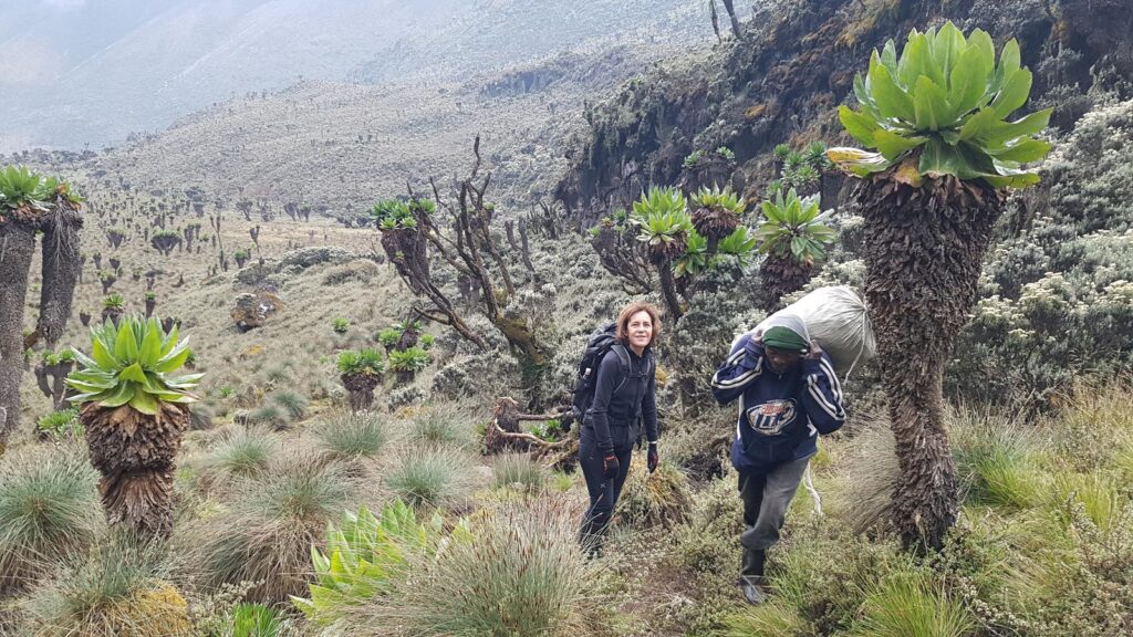
The botanical character of the trails is the Rwenzori’s most famous and most visually arresting attribute. Nowhere else on earth do hikers walk through a landscape of three-meter giant lobelias (Lobelia wollastonii) and six-meter giant groundsels (Senecio adnivalis) except in the afro-alpine zone of the Rwenzori and a handful of other East African highlands. But the Rwenzori version of this landscape is the most extensive, the most pristine, and the most dramatically located, framed by glaciated peaks and dark volcanic rock. Trekkers consistently describe day three or four on the mountain, when they first enter this alien zone, as the single most extraordinary landscape experience of their mountain-travel careers. It is a visual environment unlike anything on any other trail anywhere.
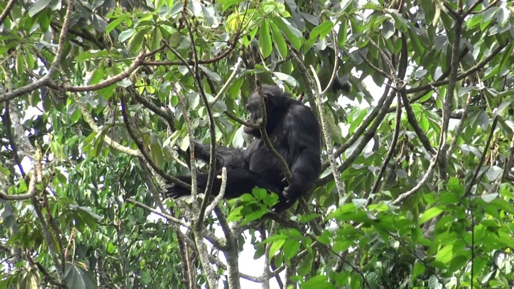
Wildlife adds yet another dimension unavailable on other African peaks. The lower forest sections of the Central Circuit and Diamond Trail pass through active chimpanzee and L’Hoest’s monkey habitat. The Rwenzori turaco, one of the most spectacular birds in Africa, is a year-round resident of the forest zone. Three-horned chameleons emerge on low branches along the Kilembe Trail in the mornings. Hyraxes call from rocky outcrops in the heathland. The Rwenzori’s trails are a wildlife corridor as much as a mountaineering route, and this multi-layered richness of experience is the fundamental reason why the mountain consistently rewards trekkers who have previously climbed both Kilimanjaro and Mount Kenya with an experience those mountains simply cannot provide. If you are weighing the comparison, our detailed guide on whether the Rwenzori is harder than Kilimanjaro provides the most honest and complete analysis available anywhere.
There are four officially maintained and fully operational trekking routes within Rwenzori Mountains National Park on the Ugandan side. Three of them, the Central Circuit, the Kilembe Trail, and the Bukurungu Wilderness Trail, are summit-capable routes that can, with the appropriate itinerary, take trekkers to the highest glaciated peaks. The fourth, the Diamond Trail, serves a different purpose entirely, focusing on wildlife and lower-mountain biodiversity rather than elevation. Every trekking expedition on the Rwenzori departs from one of these four route systems, and every itinerary in our full trek portfolio is built on one or a combination of them.
The table below summarizes the key characteristics of each route for a quick comparison, followed by a full deep-dive section on each trail.
Route
Central Circuit
Kilembe Trail
Bukurungu
Diamond Trail
Trailhead
Nyakalengeji, Ibanda
Kilembe village
Kasanzi/Omukorukumi
Nyakalengeji area
Distance
~70 km circuit
~90 km return
~80 km via lakes
~30 km lower forest
Min. Days
6–7 days (summit)
7–8 days (summit)
8–10 days
2–4 days
Highest Point
Margherita, 5,109 m
Margherita, 5,109 m
Bujuku Valley 4,000 m+
~2,500 m
Huts / Camping
Metal huts with bunks
Hut system (RTS)
Open camping only
Forest camps
Difficulty
Challenging
Very challenging
Expert wilderness
Moderate
Best For
All trekkers, 1st timers
Experienced trekkers
Expedition enthusiasts
Wildlife & day hikers
Glacier Crossing
Yes (Elena Hut route)
Yes (Margherita Camp)
No
No
Peak Season
Jun–Aug, Dec–Feb
Jun–Aug, Dec–Feb
Year-round (dry pref.)
Year-round
The Central Circuit Trail: The Classic Rwenzori Trekking Route
The Central Circuit Trail is the original and most celebrated trekking route in the Rwenzori Mountains, the path that has carried the majority of expeditions since the mountain was formally opened to international trekking in the 1950s. It is the route that established the Rwenzori’s reputation as Africa’s most extraordinary mountain wilderness, and it remains the natural first choice for the majority of trekkers approaching the range for the first time. When people think of a Rwenzori trek, they almost always picture the Central Circuit.
History and Origins of the Central Circuit
The Central Circuit follows a corridor through the Rwenzori highlands that was first documented by local Bakonzo hunters in the early twentieth century and formalized as a trekking route in the years following the Duke of Abruzzi’s historic 1906 first ascent of Margherita Peak. The Italian expedition’s pioneering route through the Bujuku Valley became the backbone of the Central Circuit, and the Uganda Wildlife Authority and its predecessors gradually built the trail infrastructure, including huts, bridges, and route markers, during the colonial period and beyond. Today, the Central Circuit is a well-maintained, internationally recognized high-altitude trekking route with a hut system that is, by the standards of the equatorial African mountain environment, genuinely excellent.
Route Profile: Trailhead, Camps, and Passes
The Central Circuit begins at the Nyakalengeji trailhead, located in Ibanda village in Kasese District, approximately 22 kilometers from Kasese town. From the park gate at 1,640 metres, the trail climbs steeply through dense montane rainforest along the Mubuku River valley to the first major camp at Nyabitaba Hut, situated at 2,651 metres and reached after approximately three to four hours of walking. This first day on the trail offers one of the finest introductions to mountain trekking anywhere in East Africa as you ascend through increasingly tall forest, cross wooden bridges over fast-running streams, and listen to the forest come alive.
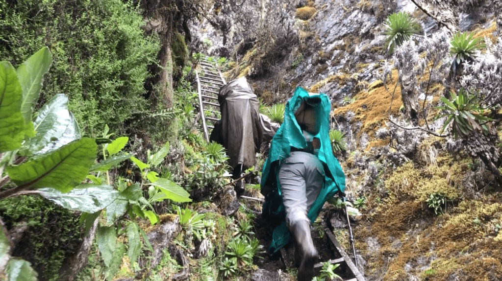
From Nyabitaba, the trail climbs progressively to John Matte Hut at 3,414 metres, passing through the transition from montane forest to giant heathland. The John Matte section shows the Rwenzori’s deep-bog terrain, where centuries of accumulated vegetation have created a spongy surface that is often knee-deep and requires careful foot placement and real physical effort. This terrain contributes most to the Rwenzori trail’s difficulty profile, and a description cannot fully convey it. It must be experienced.
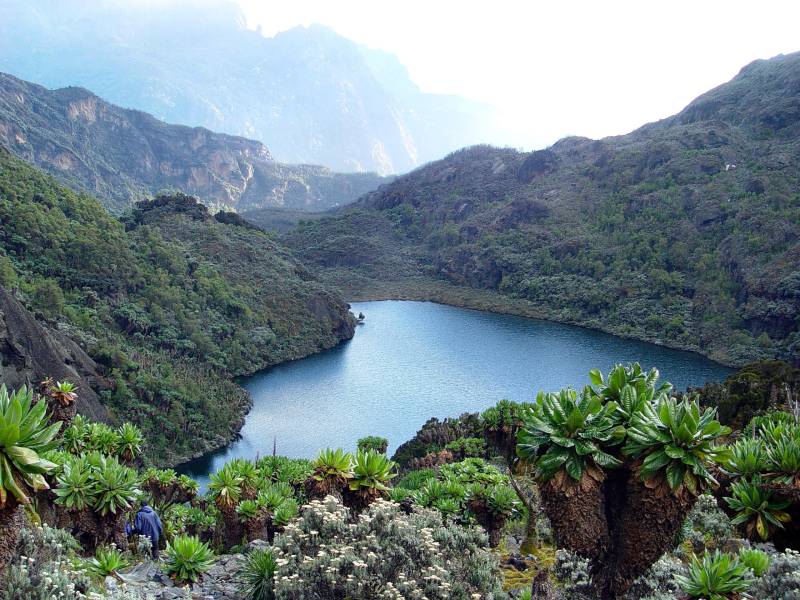
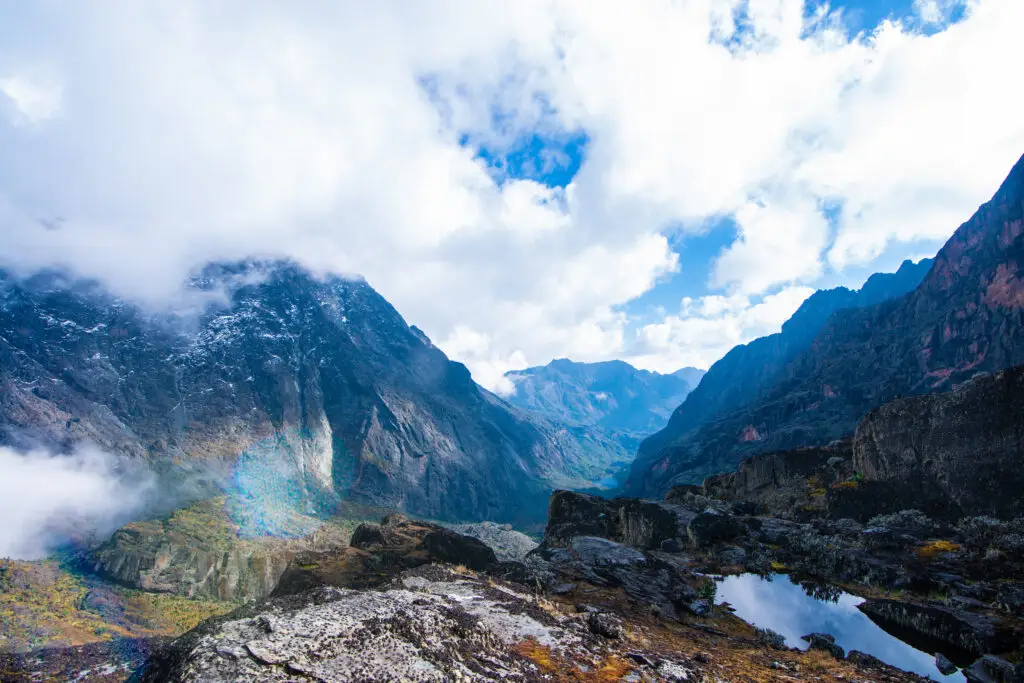
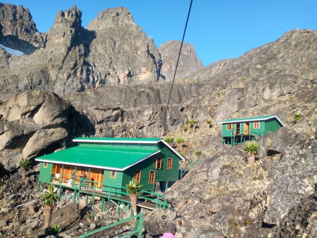
The third major camp, Bujuku Hut at 3,977 metres, sits at the heart of the range in one of the most spectacular mountain valley settings in Africa, overlooked by the dark buttresses of Mount Speke to the west and the upper Stanley massif to the north. Most itineraries place two nights here to allow an acclimatization day, during which trekkers can ascend to Freshfield Pass for views across the full northern arc of the range, an outing that, weather permitting, is one of the great mountain panoramas anywhere on the continent. The route then continues to Scott Elliot Pass at 4,372 metres before descending to Kitandara Hut at 4,023 metres, a beautiful camp beside two glacial lakes surrounded by the afro-alpine landscape at its most pristine. The final approach to Elena Hut, located at 4,541 metres, is a technical ascent through rock and ice debris above the snow line. This high camp serves as the base for summit attempts.
The main hut sequence on the Central Circuit Nyabitaba (2,651 m), John Matte (3,414 m), Bujuku (3,977 m), Elena (4,541 m), Kitandara (4,023 m), and Guy Yeoman (3,261 m) is designed to create a natural and sound acclimatization profile, with each night’s sleep at a new altitude and the summit attempt at the right physiological moment. The huts themselves are solidly built metal refuges with wooden bunk platforms, equipped with cooking areas and in some cases solar lighting. They are not luxury accommodation, but they provide genuine shelter in an environment that can deliver overnight temperatures well below freezing at the higher elevations.
The Five Vegetation Zones on the Central Circuit
One of the Central Circuit’s most important qualities is that it passes through all five of the Rwenzori’s distinct vegetation zones in order: montane forest, bamboo and heather, heathland, afro-alpine moorland, and the nival zone above the glaciers, creating a complete cross-section of the range’s extraordinary botanical diversity. Each zone has its own light quality, its soundscape, and its set of endemic species found nowhere else on earth. Moving through them in a single multi-day journey is one of the defining experiences of the Central Circuit and a major reason it remains the most recommended first trekking route in the range.
The montane forest zone, encountered on the first day and a half of the trek, holds the richest density of Rwenzori wildlife. Olive and Hartlaub’s turacos announce themselves from the canopy. L’Hoest’s monkeys watch the trail from midstory branches. Black-and-white colobus explode through the uppermost forest when disturbed. Chimpanzees inhabit the lower forest and are sometimes heard, occasionally seen, in the dense ravines west of the trail. The forest floor is a deep tangle of roots, mosses, and extraordinary tree ferns that creates the impression of walking through a living cathedral, dim-lit, immensely tall, and perpetually dripping.
Central Circuit Itineraries
The Central Circuit accommodates a remarkably wide range of itinerary lengths, from the fastest possible routes to comprehensive multi-week expeditions. The most popular single itinerary in the entire Rwenzori trekking program is the 7-day Margherita Peak climb via the Central Circuit. This itinerary provides a well-paced ascent profile, one acclimatization day at Bujuku, and a summit attempt on day six with a full descent to the trailhead on day seven. It is the route most summit-bound trekkers choose for their first Rwenzori expedition, and our guides have led this itinerary more than any other in the program.
The 6-day Central Circuit to Margherita Peak is the minimum duration we recommend for a summit attempt with a reasonable margin of safety and acclimatization. If the trek is shorter than this, the physiological adjustment required for 5,109 metres becomes genuinely challenging for most trekkers. The 9-day three-peaks expedition is the most ambitious itinerary on the Central Circuit, combining the summits of Mount Stanley, Mount Speke, and Mount Baker in a continuous traversal of the range’s three highest massifs. For a one-day introduction to the mountain without summit ambitions, the 1-day trek to Nyabitaba Camp is an outstanding option, providing a full forest immersion experience and the first dramatic views of the upper range. Similarly, the 3-day Mahoma Loop is a superb lower-mountain circuit that approaches the 2-day Lake Mahoma hike territory and returns through the forest in a complete loop without venturing to summit altitude.
The Central Circuit is the right choice for first-time Rwenzori trekkers who want the most complete experience of the range’s biodiversity and landscape variety. It is the route for those targeting Margherita Peak as their primary objective on a 6–8-day itinerary. It is the best option for trekkers who want to observe wildlife in the lower forest sections, particularly primates and birds. It is also the natural route for multi-peak expeditions targeting Mount Stanley alongside one or more of the adjacent massifs. The one trekker for whom the Central Circuit is not necessarily the first recommendation is the experienced mountain traveler who has already completed this route once and is returning for a fresh perspective; for them, the Kilembe Trail offers compelling new ground.
The Kilembe Trail: The Wild Approach Through the Nyamwamba Valley.
The Kilembe Trail approaches the Rwenzori from the south through the Nyamwamba River valley, a deeply incised gorge that carries one of the most dramatic sequences of waterfalls in East Africa and delivers trekkers into the upper mountain from an entirely different direction than the Central Circuit. It is a route of remarkable beauty and considerable challenge managed in partnership with Rwenzori Trekking Services (RTS) and the Uganda Wildlife Authority, and it has developed over the decade since its formal opening into one of the most distinctive trekking experiences available in East African mountaineering.
History and Development of the Kilembe Trail
The Kilembe Trail corridor was first mapped by the Scottish botanist Professor Scott Elliot during his 1896 traversal of the Rwenzori highlands, and the Scott Elliot Pass on the upper mountain bears his name in recognition of that pioneering journey. The trail was formally developed and opened to trekkers under the Kilembe Trail name in 2011 by Rwenzori Trekking Services, in a project that created the camp infrastructure, bridge systems, and trail markings that make today’s expeditions possible. The name Kilembe references the copper-mining village at the trail’s base, a settlement whose industrial history is itself a striking counterpoint to the pristine wilderness that begins within a kilometer of the last mine buildings.
Route Profile and Camp System
The Kilembe Trail begins at Kilembe village, approximately 13 kilometers from Kasese, and ascends through the Nyamwamba Valley. The lower sections of the trail are defined by the river itself; the Nyamwamba cascades down a series of increasingly spectacular waterfalls and gorges that are visible from the trail and accessible on short detours. The 4-day Rwenzori waterfalls hike on the Kilembe Trail targets these features specifically, and it is among the most scenic shorter trekking experiences available on any African mountain.
The camp system on the Kilembe Trail uses the Rwenzori Trekking Services hut and campsite infrastructure, with named camps at Sine (2,600 m), Mutinda (3,700 m), Bugata (4,062 m), Hunwicks (4,350 m), and Margherita Camp (4,540 m). Each camp is well-maintained, with cooking facilities, basic sleeping platforms, and in some cases solar charging. The camp names are different from the Central Circuit’s hut names, and understanding this distinction is important when planning cross-route itineraries or comparing the two systems. Margherita Camp, the high camp below Mount Stanley on the Kilembe Trail, is the equivalent of Elena Hut on the Central Circuit in terms of its role in the summit push, and it sits at approximately the same altitude.
The 4-day Mutinda Lookout trek takes trekkers up to approximately 4,000 metres on the Kilembe Trail without attempting the summit, following the ‘climb high, sleep low’ acclimatization principle that our guides use as an excellent preparation exercise for trekkers considering a future full summit attempt. Mutinda Camp offers some of the finest panoramic mountain views on the trail, looking north across the Nyamwamba valley toward the summit massifs, and these views rival anything available from the same elevation on the Central Circuit.
The Kilembe Trail Summit Itineraries
The flagship summit itinerary on the Kilembe Trail is an 8-day trek to Margherita Peak via Kilembe. The extra day this format provides compared to the minimum 7-day option delivers better physiological outcomes on summit day, particularly for trekkers who may be more susceptible to altitude effects. Our guides consistently observe higher summit success rates on the 8-day format than on shorter alternatives, and this is the itinerary we recommend as the standard approach to Margherita Peak via the Kilembe route.
For trekkers targeting specific secondary peaks, the Kilembe Trail offers outstanding options that are not as readily available on the Central Circuit. The 6-day Weismann Peak expedition targets the higher of Luigi di Savoia’s two summits, a beautiful and relatively accessible high-altitude objective that rewards with sweeping views across the southwestern sectors of the range. The 7-day Mount Baker and Weismann Peak trek combines two major summits in a single Kilembe Trail itinerary. The 8-day Cheptegei Peak trek goes to one of the less-visited but truly rewarding Rwenzori summits at 4,907 metres via the Kilembe corridor, passing through the Nyamwamba Valley in hushed high-altitude conditions.
The 2-day Sine Camp trek is the ideal short introduction to the Kilembe Trail for trekkers who cannot commit to a full summit expedition. Reaching Sine Camp at 2,600 metres on a nine-kilometer round journey, it passes through the lower forest zone at its most biodiverse, with three-horned chameleons, blue monkeys, and a remarkable density of bird species along the trail. For those wanting a slightly longer lower-mountain experience, the 3-day Sine Camp and Samalira Falls trek adds a full day to reach the dramatic Samalira Falls before the return descent.
Who Should Choose the Kilembe Trail
The Kilembe Trail is the natural choice for trekkers who have already completed the Central Circuit and are returning to the Rwenzori for a new perspective. It is also well-suited to those who prefer a more challenging, less-visited route and do not need the gentler learning curve of the Central Circuit. The Kilembe approach through the Nyamwamba Valley delivers a different aesthetic experience, more dramatic in its lower sections and more vertically demanding in its ascent profile, that many experienced mountain travelers prefer. Trekkers specifically targeting Weismann Peak on Luigi di Savoia, or seeking a waterfall-focused lower-mountain experience, will find the Kilembe Trail superior for these purposes. For a comprehensive comparison, our detailed guide on Central Circuit versus Kilembe Trail, which route is better, is the definitive resource.
The Bukurungu Wilderness Trail: The Rwenzori’s Final Frontier
The Bukurungu Wilderness Trail is the Rwenzori’s wilderness frontier, a route that sees perhaps a few dozen expeditions per year and traverses a part of the range that exists almost entirely outside the awareness of the international trekking community. Developed in 2018 as a joint initiative between the Uganda Wildlife Authority and the World Wildlife Fund for Nature, the Bukurungu Trail creates a new approach corridor through the western sectors of the national park, passing between Portal Peaks and Mount Gessi before intersecting with the Central Circuit in the Bigo Swamp. It is a route of extraordinary scenic power and genuine exploratory character that no other trail in the Rwenzori system can match.
Trail Overview and Character
Unlike the Central Circuit and Kilembe Trail, the Bukurungu is a full wilderness camping route. There are no permanent huts on this trail. Everything is carried in sleeping shelters; cooking equipment, food, and camps are established in the open mountain. The Uganda Wildlife Authority maintains the route and provides designated camping sites, but the experience is qualitatively different from the hut-based trekking of the other two main routes: rougher, more exposed, and more genuinely remote. This is the Rwenzori as the early explorers experienced it, before the infrastructure of managed mountain tourism arrived. For expedition-minded trekkers who have already completed one of the main routes, the Bukurungu offers an entirely new chapter in their Rwenzori experience.
The trail enters the national park through the Kasanzi gate near Omukorukumi and follows a corridor through the lower ranges that are mostly unexplored by trekkers. Its most celebrated feature is the sequence of four high-altitude alpine lakes: Irene, Mughuli, Bukurungu, and Bujuku, encountered in succession as the trail ascends through the afro-alpine zone. These lakes, sitting in open mountain terrain at altitudes between 3,800 and 4,000 metres, are among the most beautiful and most remote landscape features in the entire Rwenzori system. Mountain rivers, cascading waterfalls, and the complete absence of other trekking parties create a sense of immersion in genuine wilderness that is increasingly rare anywhere in African mountain travel.
Who Should Choose the Bukurungu Trail
The Bukurungu Trail is appropriate for experienced trekkers who have already completed at least one full Rwenzori summit expedition, who are comfortable in open mountain camping conditions, and who are seeking an experience of genuine wilderness rather than a managed summit route. It requires higher levels of self-sufficiency, a strong fitness baseline, and ideally some prior familiarity with the Rwenzori’s climatic conditions. It is not appropriate for first-time Rwenzori visitors, those seeking summit access to Margherita Peak as a primary objective on a standard itinerary, or those who require the security and comfort of the fixed hut system. For the right trekker, however, it is one of the most rewarding routes in East African mountaineering.
The Diamond Trail: Wildlife-First Trekking in the Lower Rwenzori
The Diamond Trail is the fourth official trekking route in the Rwenzori system and the one most different in purpose and character from the others. The Central Circuit, Kilembe, and Bukurungu trails are mainly summit routes that take trekkers through the vegetation zones and up to the glaciated peaks, while the Diamond Trail is a wildlife-first route in the lower montane forest zone that is specifically designed to maximize opportunities for primate and bird sightings. It is the single best option in the national park for dedicated chimp and bird watching, and it is an outstanding choice for trekkers who want a Rwenzori forest experience without committing to the physical and logistical demands of a summit expedition.
The trail runs through the park’s richest primate habitat, a sector of the lower forest where chimpanzee groups are regularly encountered and where L’Hoest’s monkeys, Rwenzori colobus, and grey-cheeked mangabeys are frequently visible from the trail. The birdwatching along this route is exceptional: the Rwenzori Mountains are one of Africa’s top endemic birding destinations, with over 200 bird species recorded in the national park, many of them found only in the Albertine Rift zone. Birdwatchers regularly observe the Rwenzori turaco, the handsome francolin, the Archer’s robin-chat, and a remarkable suite of sunbird species on Diamond Trail walks. For combination trekkers who want to experience both the summit routes and the wildlife of the lower forest, the Diamond Trail works well as a one-to-two-day addition at the start or end of a Central Circuit expedition.
Choosing Your Rwenzori Route: The Decision Framework
The choice between Rwenzori trekking routes is one of the most important decisions in your expedition planning, and it deserves careful thought rather than a rushed conclusion. The summary comparison table earlier in this article gives you the headline data. Here is how to apply that data to your specific situation.
If this trek is your first time on the Rwenzori and your primary goal is to reach Margherita Peak, choose the Central Circuit. It is the route with the most comprehensive infrastructure, the widest traversal of the range’s landscape zones, and the most reliable acclimatization profile for first-time visitors. The 7-day itinerary is the benchmark. The 8-day Central Circuit alpine expedition provides even more margin for acclimatization and is worth the extra day for trekkers with any history of altitude sensitivity.
If you have already completed the Central Circuit and want a fresh perspective on the mountain, or if you are specifically targeting Weismann Peak or the Kilembe Trail’s distinctive waterfall and valley scenery, choose the Kilembe approach. The 8-day format is the standard recommendation. If you are an experienced expedition mountaineer seeking the maximum wilderness experience and have prior Rwenzori knowledge, the Bukurungu Trail is the obvious choice. And if wildlife and birding are the primary objective without summit ambitions, the Diamond Trail delivers the best of the lower mountain.
Our dedicated guide on the difference between the Central Circuit and Kilembe Trail is the most comprehensive resource available for a full analytical comparison of difficulty, scenery, camps, cost, and which trekker each route suits. If you are still undecided after reading this guide, contact our team directly via WhatsApp for a personalized recommendation based on your specific objectives.
Multi-Peak Expeditions: Combining Routes to Climb the Full Rwenzori Crown
For trekkers who want more than a single summit, the Rwenzori offers a multi-peak expedition program that is among the most ambitious and rewarding itineraries available in African mountaineering. The range has six major massifs that are spread out so that multi-peak traversals are really possible during long expeditions, and our guide team has the special skills needed to plan and carry out these complex itineraries safely.
The 8-day three-peaks trek targeting Mount Stanley, Speke, and Baker is the entry point to multi-peak Rwenzori expeditions. Combining the three highest summits in the range via the Central Circuit traversal, it is one of the most rewarding eight-day mountain itineraries available anywhere in East Africa. The 10-day four-peaks expedition, which targets Margherita, Speke, Weismann, and Baker, adds Weismann Peak on Luigi di Savoia to the three-peaks circuit, extending the high-altitude traversal and providing a more complete experience of the range’s upper zones.
The 13-day six-peaks grand expedition is the most comprehensive Rwenzori trekking experience available within a conventional expedition timeframe. Summiting all six major massifs, Mount Stanley, Speke, Baker, Emin, Gessi, and Luigi di Savoia, this trek is the itinerary that represents genuine Rwenzori mastery. Very few operators anywhere in the world are equipped to deliver this expedition safely, and it requires guides with deep specific knowledge of the full range. At the top of ambition is the 18-day all-eight-peaks expedition, which covers every named summit in the Rwenzori system and is the most complete way to finish the range by any measure. Trekkers who complete this expedition join an extremely select group.
What You Will Experience on Any Rwenzori Trekking Route
The Five Vegetation Zones in Detail
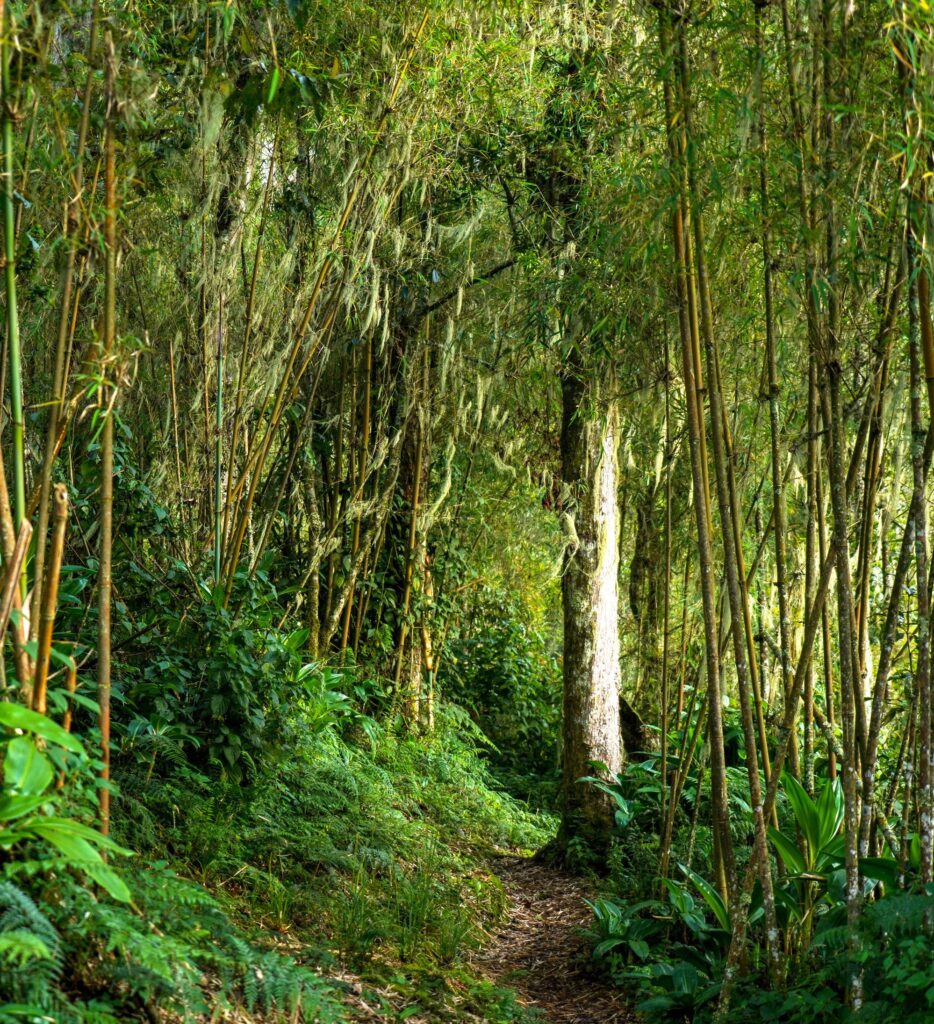
Regardless of which Rwenzori trekking route you choose, any itinerary that ascends toward the summit will carry you through a sequence of landscape zones of escalating strangeness and beauty. The five vegetation zones are not merely ecological classifications; they are genuinely distinct worlds, each with its atmosphere, terrain character, and resident species. The montane rainforest zone between 1,600 and 2,500 metres is the most biodiverse and most audibly alive: here is where the forest closes above you and the outside world recedes entirely. The bamboo and giant heather zone between 2,500 and 3,200 metres marks the transition into the mountain’s alpine character, with the trail narrowing between bamboo stems and the first patches of bog appearing underfoot. The heathland zone, at an altitude of 3,200 to 3,800 metres, is characterised by deep, ancient peat bogs and the signature giant heather tree species, Erica arborea, growing to extraordinary proportions in the saturated mountain climate.
The afro-alpine moorland above 3,800 metres is the landscape that consistently produces the most powerful reactions in first-time Rwenzori trekkers, a zone that appears, in all honesty, to belong to another planet. Giant lobelias stand at three metres or more, their rosettes of silver-grey leaves forming architectural columns along the ridgelines. Giant groundsel trees, their trunks thick and shaggy with dead leaves, reach heights of five to six metres and create a forest of improbable botanical sculptures. The volcanic rock outcrops are covered in brilliant green and orange mosses. The sky, when it appears, is a deep equatorial blue at 4,000 metres. And above it all, the first thin lines of permanent snow appear on the upper faces of the peaks. Nothing in any prior mountain experience prepares you for this zone. It is one of the most remarkable botanical landscapes of the earth.
Wildlife Encountered Along the Trails
The wildlife profile of any Rwenzori trekking route depends heavily on elevation. The lower forest sections are the first one to two days of any route that begins from the national park gates, where the probability of primate sightings is highest. Chimpanzees inhabit the montane forest between approximately 1,600 and 2,200 metres, and although they are not habituated for close encounters in the way that Bwindi’s gorillas are, hearing and occasionally observing them in the upper forest canopy is a genuine and moving experience. L’Hoest’s monkeys, a large, dark, forest-specialist species endemic to the Albertine Rift, are the most reliably seen primate on any Rwenzori trail.
The Rwenzori turaco is the single most striking bird along any of the routes, a large, crested, crimson-winged species whose colors seem almost artificially vivid in the green light of the forest. The three-horned chameleon, one of the most distinctive reptiles in East Africa, is regularly encountered on low vegetation along the Kilembe Trail and in the lower Central Circuit forest during morning hours. Hyraxes, those small, rabbit-like mammals that are more closely related to elephants than to any rodent, call from rocky outcrops in the heathland zone at dusk. For trekkers combining wildlife with mountaineering, our dedicated Rwenzori wildlife guide covers the full species roster and the best observation conditions on each trail.
Mountain Huts, Camps, and What to Expect on Trail
The accommodation system on the Central Circuit and Kilembe Trail is built around fixed mountain huts, solidly constructed metal shelters with wooden sleeping platforms, blankets available at some sites, cooking areas with firewood, and basic toilet facilities. These huts are not luxury lodges; they are functional mountain refuges appropriate to the environment and purpose. Trekkers sleeping in the huts bring their sleeping bags (rated to at least minus ten degrees Celsius), their cooking equipment, and food carried by the porter team. The full details of the hut system, what is provided, and how to prepare for mountain accommodation are covered in our guide to Rwenzori mountain accommodation.
Daily distances on the trail vary between 8 and 16 kilometers depending on the day’s itinerary, but the figures are somewhat misleading: distance is not the primary metric of effort on the Rwenzori. A 10-kilometer day on saturated bog and steep root terrain can require more effort than a 20-kilometer day on a dry valley path. Plan your expectations around walking time, typically five to eight hours per day on summit routes, rather than distance.
Weather and Trail Conditions
The Rwenzori is one of the wettest mountain ranges in Africa, and this is a fundamental fact of any trekking experience on its trails. Rain is possible in every month of the year. The two drier windows, December to February and June to August, deliver reduced rainfall and generally better summit visibility, but even in these periods, rain is not absent. Trail conditions reflect this reality: the bogs and root sections that characterize the middle elevation zones are always wet to some degree, and trekkers must be prepared for muddy, saturated trail surfaces throughout any expedition. The best time to visit the Rwenzori covers the seasonal variations in detail and provides guidance on choosing the right expedition window for your priorities.
⚠️ Important
Standard waterproof hiking boots are inadequate for Rwenzori trail conditions. The deep bogs of the middle elevation zones will penetrate any conventional boot, however expensive. Rubber Wellington-style boots over neoprene sock liners are the correct footwear for Rwenzori trekking routes. See our complete boot guide for full guidance.
Planning Essentials for Your Rwenzori Trekking Route
How Long Do You Need?
The minimum duration for a summit attempt on Margherita Peak via either the Central Circuit or Kilembe Trail is 6 days, with 7 days being the standard recommended duration and 8 days the preferred benchmark for optimal acclimatization and a higher summit success rate. Shorter itineraries of 4–5 days carry meaningfully elevated altitude risk and are appropriate only for experienced trekkers with prior high-altitude exposure. For a detailed analysis of every available timeframe, our guide on how long a Rwenzori trek takes examines every itinerary option, from the fastest possible summit routes to the 18-day all-peaks expedition.
Fitness, Difficulty, and Who Can Do This
The difficulty of Rwenzori trekking is best described as ‘harder than Kilimanjaro in terrain, comparable in altitude risk.’ The principal difficulty factors are the saturated, complex trail surface; the technical demands of the glacier crossing on summit day; and the cold, wet conditions that prevail throughout the upper mountain. A detailed training program specifically targeted at Rwenzori terrain is our 16-week training plan, developed specifically for the physical demands of these trails.
The Rwenzori is achievable for well-prepared first-time mountain trekkers, as our beginners’ guide to climbing the Rwenzori explains in honest detail. It is also very much achievable for older trekkers. Our guide for hikers over 50 and 60 trekking the Rwenzori draws on direct experience guiding clients in their sixties and seventies to the summit. The key prerequisite across all ages and experience levels is genuine aerobic fitness, strong leg muscles, and the right preparation.
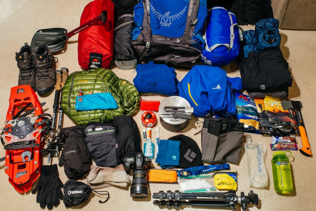
Essential Gear for Rwenzori Trekking Routes
The complete Rwenzori packing list covers every item in detail. The headline principles are rubber boots (not hiking boots), a sleeping bag rated to minus 10°C, full waterproof outerwear, a layering system designed for humid cold and dry cold simultaneously, and trekking poles (which are essential for bog navigation and steep descents). Our Rwenzori boot guide addresses the single most consequential gear decision in detail, and our guide on staying warm on the Rwenzori summit covers the layering strategy required for Elena Hut and above. The guide team provides crampons and ice axes; these are included in expedition costs and do not need to be sourced independently.
What a Guided Expedition Costs in 2026
A fully guided Rwenzori trekking expedition to Margherita Peak inclusive of national park fees, guide and porter wages, mountain hut accommodation, and agency logistics typically costs between USD 1,200 and USD 3,500 per person for a 7–8-day itinerary, depending on group size and specific route. Multi-peak expeditions are priced proportionally higher. The complete 2026 Rwenzori cost breakdown provides exact per-person pricing for every itinerary in the program. For trekkers managing a tighter budget without compromising safety, our budget Rwenzori trekking guide identifies legitimate cost-reduction strategies.
Your Guide and Porter Team
Under any circumstances, you cannot trek in Rwenzori Mountains National Park without a UWA-certified guide. This is both a legal requirement and, on the Rwenzori’s genuinely complex terrain, a genuine safety necessity. Every guide working with Rwenzori Trekking Safaris is a certified, experienced Bakonzo mountain professional, a member of the indigenous community whose families have lived on these slopes for generations. Our guide to Rwenzori porters and guides explains the team structure, logistics, and the daily roles of the guide and porter systems. Tipping the team appropriately at the expedition’s end is an important expression of respect for their expertise; our porter and guide tipping guide provides clear norms.
Health, Safety, and Altitude on the Trail
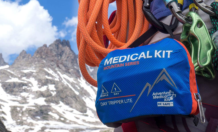
The complete medical guide to Rwenzori trekking covers altitude sickness, hypothermia, trench foot, and the full range of health challenges on these trails. The key principle is that altitude sickness is real at 5,109 metres and must be managed consciously throughout the itinerary. The Rwenzori’s wet, cold conditions can mask the early signs of AMS, making experienced guide monitoring especially valuable. Our acclimatization strategy guide explains the specific physiological approach used on every Rwenzori expedition. The Rwenzori safety record is excellent when expeditions are conducted with professional guides, and the factors that most closely correlate with summit success are itinerary length and guide quality. Travel insurance covering high-altitude rescue and medical evacuation is non-negotiable; see our Rwenzori travel insurance guide for the specific coverage required.
🧭 Guide Insight
The most common reason for a failed summit attempt on any Rwenzori route is not poor fitness; it is inadequate acclimatization. Trekkers who rush to the summit on short itineraries consistently achieve lower success rates. The mountain rewards patience. Give it the time it asks for, and it will almost certainly deliver the summit.
Getting to the Rwenzori Trekking Routes: Travel Logistics
The gateway to all Rwenzori trekking routes is Kasese town in western Uganda, approximately 420 kilometers from Kampala and six hours from Entebbe International Airport by private road transfer. Domestic flights to Kasese Airport are available on select days via regional carriers and reduce the transfer time to approximately one hour. The complete travel guide to reaching the Rwenzori covers all transport options. Most trekkers spend one night in or near Kasese before the trek begins; our pre- and post-trek accommodation guide covers all available options around both the Central Circuit trailhead at Nyakalengeji and the Kilembe trailhead south of town.
Combining Rwenzori Trekking Routes with Uganda’s Wildlife
Uganda safaris combine extraordinarily well with Rwenzori trekking because the mountain sits at the center of one of the most wildlife-dense regions in East Africa. Bwindi Impenetrable Forest, home to approximately half the world’s remaining mountain gorillas and the primary destination for gorilla trekking in Uganda, is approximately four hours by road from Kasese. The combination of a Rwenzori glacier crossing one week and a forest encounter with mountain gorillas the next is, by any measure, the finest two-week adventure available anywhere on the African continent. We designed our 12-day Rwenzori and gorilla trekking package specifically for this combination.
If you need any clarification about a Rwenzori trek, contact one of our trekking experts to start planning your journey today.
A 10% percentage of your safari proceeds goes to supporting the local Bakonjo Communities (orphans, schools & homes)
There are four official trekking routes currently operating within Rwenzori Mountains National Park on the Ugandan side of the range. The Central Circuit Trail is the original and most popular route, beginning at the Nyakalengeji trailhead near Ibanda and looping through the Bujuku Valley to the high camps below the Stanley Plateau. The Kilembe Trail approaches from the south through the Nyamwamba Valley, starting at Kilembe village near Kasese, and offers a different and equally spectacular approach to the summit massifs. The Bukurungu Wilderness Trail is a wilderness camping route developed in 2018, passing through four high-altitude alpine lakes in the western sectors of the park. The Diamond Trail operates in the lower montane forest and is specifically designed for wildlife and bird observation rather than summit access.
For first-time Rwenzori trekkers, the Central Circuit Trail is the most appropriate route. It has the most established infrastructure, the clearest acclimatisation profile, the widest variety of landscape zones, and the most reliable summit access for a 7-day itinerary. The Kilembe Trail, while extraordinary, is generally considered more physically demanding and is better suited to those with prior high-altitude trekking experience. The complete beginners’ guide explains exactly what preparation first-timers on the Central Circuit need and which itineraries are most appropriate for them.
The recommended minimum duration for a Margherita Peak summit attempt via the Central Circuit is 7 days, with 8 days strongly preferred for better acclimatisation and a higher summit success rate. Via the Kilembe Trail, the recommended standard is 8 days. Shorter 4–5-day summit itineraries exist but carry meaningfully elevated altitude risk and are appropriate only for experienced trekkers with prior high-altitude exposure. The complete guide to how long a Rwenzori trek takes covers every available itinerary option from the fastest possible routes to the 18-day all-peaks expedition.
The Central Circuit begins at Nyakalengeji near Ibanda and loops through the Bujuku Valley, passing through the widest variety of the Rwenzori’s five vegetation zones and offering access to the greatest range of summit objectives. The Kilembe Trail begins at Kilembe village and ascends through the Nyamwamba Valley, with a different aesthetic character that is more dramatic in its lower waterfall sections and provides access to a different set of camp names and summit approaches. The Central Circuit is generally recommended for first-time Rwenzori visitors; the Kilembe Trail suits experienced trekkers, those returning for a second perspective on the mountain, and those specifically targeting peaks more accessible from the south. Our detailed guide on Central Circuit vs. Kilembe Trail provides the complete comparison.
The main hut sequence on the Central Circuit is Nyabitaba Hut (2,651 m), John Matte Hut (3,414 m), Bujuku Hut (3,977 m), Elena Hut (4,541 m, the summit high camp), Kitandara Hut (4,023 m), and Guy Yeoman Hut (3,261 m). Each hut is a solidly built metal refuge with bunk platforms and cooking areas, spaced to create a natural acclimatisation profile across the ascent. The route forms a loop rather than an out-and-back, so trekkers experience different terrain and valley views on the ascent and descent legs.
The Kilembe Trail camp sequence, managed by Rwenzori Trekking Services, runs from Sine Camp (2,600 m) through Mutinda Camp (3,700 m), Bugata Camp (4,062 m), and Hunwicks Camp (4,350 m) to Margherita Camp (4,540 m), the high camp for summit attempts on the Kilembe approach. Unlike the Central Circuit, the Kilembe Trail operates as an out-and-back on most itineraries rather than a loop, though cross-route combinations via the Scott Elliot Pass are possible. Full camp details, including facilities and sleeping arrangements, are covered in our Rwenzori mountain accommodation guide.
Rwenzori trekking difficulty is higher than Kilimanjaro primarily due to terrain rather than altitude. The trails are not technically graded mountaineering routes below the glacier crossing, but they demand genuine physical fitness, strong ankles, good footwork on rough terrain, and the psychological resilience to walk in wet, cold conditions for multiple consecutive days. Well-prepared first-time mountain trekkers can and do summit Margherita Peak successfully every season, provided they follow a structured fitness program, choose an appropriately long itinerary, and use proper gear. The fitness requirement guide provides honest and specific advice on the baseline fitness needed for different Rwenzori itineraries.
The two preferred windows for Rwenzori trekking are December through February and June through August, when rainfall is at its lowest and summit weather windows are most frequent. The Rwenzori receives some precipitation in every month, so no period is entirely dry. The wet season months, March through May and October to November, bring heavier rainfall, muddier trails, and reduced summit visibility, but also fewer other trekkers, lower combination package prices, and an intensified wilderness atmosphere that experienced mountain travelers often actively prefer. With proper waterproof gear and experienced guides, the Rwenzori is a viable and rewarding trekking destination year-round. Full seasonal details are in our best time to visit the Rwenzori guide.
Yes. The Uganda Wildlife Authority requires all trekkers within Rwenzori Mountains National Park to be accompanied by a UWA-certified guide at all times on all routes, including the Central Circuit, Kilembe Trail, Bukurungu Trail, and Diamond Trail. This is not merely a formal requirement: on the Rwenzori’s genuinely complex terrain, a qualified guide is the single most important factor in the safety and success of your expedition. All guides working with Rwenzori Trekking Safaris are UWA-certified, experienced Bakonzo mountain professionals with detailed knowledge of every route and camp in the system.
Hi there, welcome. Need help planning a trek, safari, or adventure? Chat directly with a real expert and mountain guide for honest advice, clear answers, and practical recommendations. No guesswork, no pressure.