Climb Mount Emin (4,798m) in 7 days via the Rwenzori Central Circuit. Expert guides, Kitandara Lakes, and Umberto Peak are all part of the experience. One of Africa’s rarest summits. Book today.
7-Day Mount Emin Trek | Rwenzori Mountains, Uganda
Overview of the 7-Day Mount Emin Trek
Rwenzori Mountains, Uganda | Summit Umberto Peak at 4,798m | Central Circuit
Climb one of Africa’s most rarely ascended peaks. Seven days through the Rwenzori’s Afro-alpine heartland from ancient forest to the glacial basin of the Kitandara Lakes and the rocky summit of Umberto Peak, 4,798 metres above the equatorial plains.
Explore Mount Emin on this remarkable 7-day Mount Emin hiking itinerary that offers a unique adventure in the Rwenzori Mountains. The journey is a combination of challenges and rewards, with breathtaking landscapes, beautiful scenery, and a deep connection to nature. Each day immerses you in a unique and beautiful environment within the Rwenzori Mountains, allowing you to enjoy scenic views of the diverse vegetation and climatic conditions found there.
The journey on this ancient Central Circuit route takes you through the Nyabitaba and John Matte camps of the Rwenzori Mountains. It also has a camping experience at the Skul Cave and Lac de Luna campsites, respectively. Join this once-in-a-lifetime adventure either in a group or solo and discover the hidden beauty of the Rwenzori Mountains.
Trek at a Glance: 7-Day Mount Emin Trek
| Duration | 7 Days / 6 Nights |
| Total Distance | Approx. 55–60 km (full circuit) |
| Summit Elevation | 4,798 m Umberto Peak, Mount Emin |
| Starting Elevation | 1,646 m (Nyakalengija Trailhead) |
| Difficulty | Strenuous high-altitude technical scrambling to summit |
| Start & End Point | Nyakalengija Trailhead, near Ibanda, western Uganda |
| Trek Route | Central Circuit Trail, Rwenzori Mountains National Park |
| Key Landmark | Kitandara Lakes (4,023 m): twin glacial lakes below Emin |
| Best Seasons | June–August (long dry) & December–February (short dry) |
| Group Size | 1–12 trekkers (private or small group) |
| Accommodation | Rustic trail huts at each camp (mattresses provided) |
| Meals | Full board, all meals prepared by your team cook |
| Price | From $1,200 Per person |
Why Climb Mount Emin? The Case for the 7-Day Trek
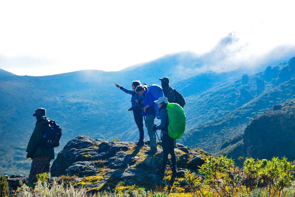
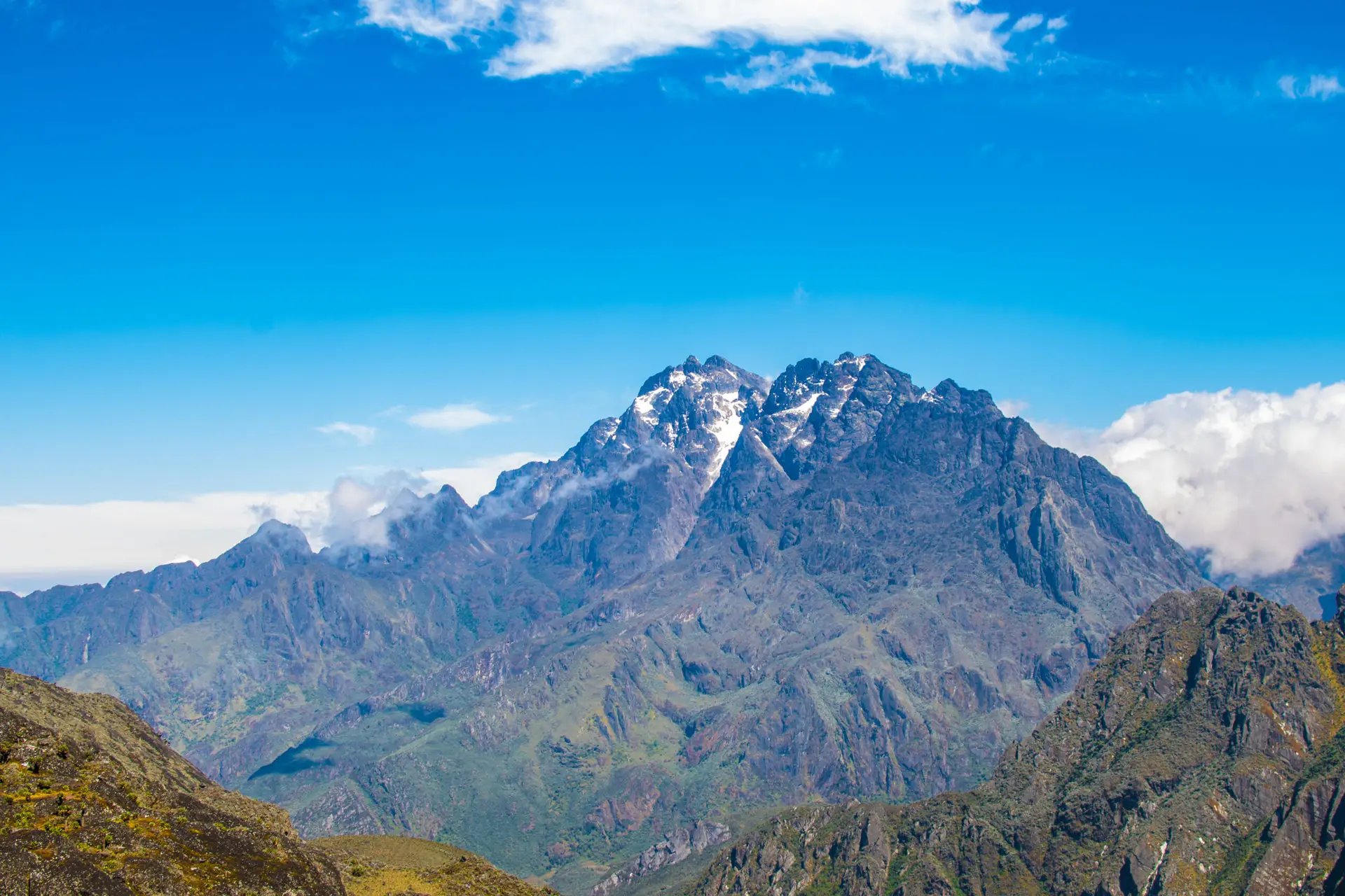
Of the six towering peaks in the Rwenzori Mountains, none commands the combination of altitude, remoteness, and sheer geological drama that Mount Emin delivers. Rising to 4,798m at its Umberto Peak, the fifth highest point in the entire range, Emin sits in the southwestern quadrant of the massif, above the twin glacial Kitandara Lakes, in a landscape so otherworldly that even seasoned high-altitude trekkers describe it as unlike anything they have seen before. This peak is not a mountain you will share with a crowd. While Mount Stanley and Margherita Peak draw the majority of serious summit attempts, Emin remains one of the most rarely climbed significant peaks in all of Africa, and that rarity is precisely its appeal.
Named after Eduard Schnitzer, known to history as “Emin Pasha,” the Ottoman-born governor of Equatoria province whose famously troubled rescue by Henry Morton Stanley in 1887 drew global attention to the Rwenzori, this peak carries a weight of history as heavy as its elevation. The mountain was first summited in 1906 by the Duke of Abruzzi’s Italian expedition, the same party that made the first recorded ascent of Margherita Peak. For 120 years since that expedition, only a tiny fraction of the world’s mountaineers have stood on Umberto Peak. The 7-Day Mount Emin Trek gives you your chance to join them with our expert Bakonzo guides and a fully supported expedition, ensuring every practical detail is handled.
The 7-day itinerary follows the Central Circuit Trail from Nyakalengija through the range’s iconic sequence of ecological zones: Afromontane forest, bamboo belt, giant heather cathedral, and the full sweep of the Afro-alpine world before routing west at Scott Elliott Pass (4,372m) to descend to the Kitandara Lakes basin. Day 5 is the summit day: a challenging ascent of Umberto Peak’s rocky south ridge that delivers summit views encompassing Mount Baker, Mount Gessi, the Kitandara Lakes far below, and, on clear days, the snow dome of Mount Stanley to the north. With fewer than 1,000 trekkers visiting the Rwenzori per year across all its routes, this specific summit sees perhaps a few dozen visitors annually. This is rare mountaineering by any global standard.
Our 13-Day Rwenzori 6 Peaks Expedition includes Emin as one of the six summits in a grand traverse of the entire range, catering to trekkers who want to extend beyond Emin. Those who want to compare the Mount Emin experience against other high-altitude Rwenzori objectives should read our guide to the Central Circuit vs Kilembe Trail before making their decision.
Full Day-by-Day Itinerary: 7-Day Mount Emin Trek
Day 1: Nyakalengija Trailhead → Nyabitaba Camp
Elevation: 1,646m → 2,652m | Distance: ~8 km | Hiking Time: 4–5 hours
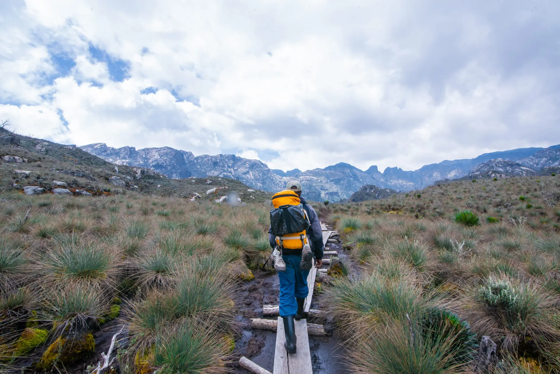
Your 7-Day Mount Emin Trek begins at Nyakalengija (1,646m), the main trailhead for the Central Circuit, located approximately 22km northeast of Kasese town. After registration at the Uganda Wildlife Authority gate, your guide team assembles the same Bakonzo families who have guided trekkers into this mountain for generations, and the trail enters the national park within minutes. The Nyakalengija trailhead is a place of controlled excitement: the last flat ground you will see for days.
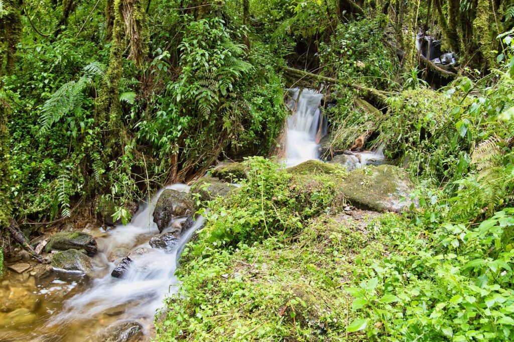
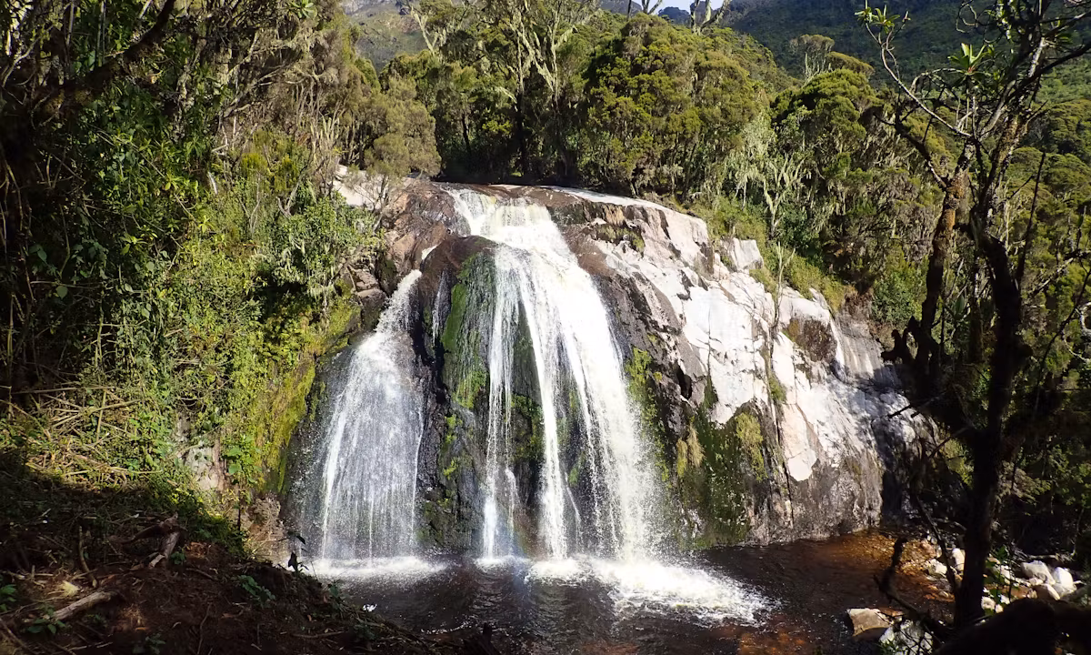
The Day 1 trail climbs steeply through the lower montane forest, gaining over 1,000 metres in elevation across 8 kilometers of rooted, often muddy path. The Afromontane forest here is very dense; Podocarpus milanjianus and Hagenia abyssinica grow tall above, and the understory is full of blooming Mimulopsis, Impatiens, and Begonia species. Look for the red-tailed monkey in the middle canopy, and listen for the two-tone call of the Rwenzori turaco, Africa’s most striking forest bird and an unmistakable indicator that you have entered genuine wilderness. The trail crosses the Mubuku River on a log bridge at mid-elevation before the final push to camp. See our full Rwenzori wildlife guide for a complete species overview by zone.
Nyabitaba Camp at 2,652m is the first significant camp on the Central Circuit, a collection of huts on a wide ridge above the forest with the first open views across the Mubuku Valley. The camp has historically been used as a staging point for all multi-day Central Circuit expeditions. At 2,652m, altitude effects are minimal for most trekkers, but the body is already working harder in the thinner air. A full hot dinner, your guide’s evening briefing, and an early bedtime prepare you for the bigger days ahead.
Highlights: Mubuku River log bridge crossing, first Rwenzori turaco sightings, open ridge views from camp toward Kasese and the Albertine Rift Valley
Sleep: Nyabitaba Camp (2,652m) shared hut dormitory, foam mattresses, toilet block
Day 2: Nyabitaba Camp → John Matte Camp (3,505m)
Elevation: 2,652 m → 3,414 m | Distance: ~8 km | Hiking Time: 5–7 hours
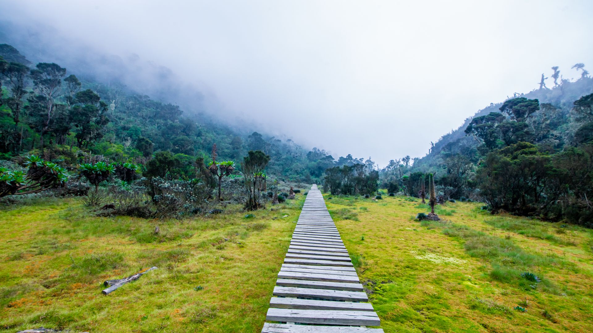
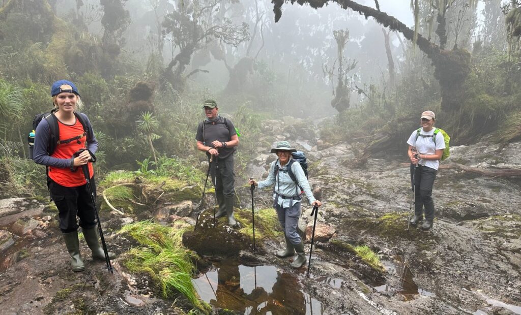
Day 2 is one of the botanically richest days of the entire 7-Day Mount Emin Trek, climbing from the montane forest through the bamboo zone and into the giant heather world above. The trail leaves Nyabitaba and drops briefly to cross the Bujuku River before beginning a sustained ascent along the ridge, a climb that takes you through a sequence of vegetation zones so distinct that each feels like entering a different world. Read more about the botanical transitions in our guide to the vegetation zones of the Rwenzori.
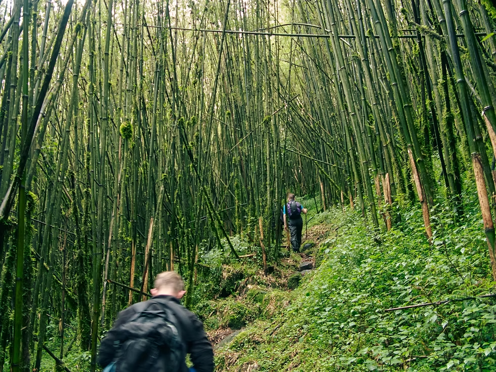
The bamboo section begins at approximately 2,800m, with towering culms of Arundinaria alpina forming a cathedral ceiling over the trail. This area is elephant habitat (spoor and bark-stripping evidence are often visible), though actual encounters are rare. The bamboo gives way abruptly to a transitional heathland of Hypericum trees and Philippia before the trail enters the full giant heather zone at around 3,000m, where Erica arborea grows to 8 metres tall and every branch is draped in silver-grey lichen. The trail is often narrow and partially waterlogged in this section; rubber boots are invaluable if rented in Kasese.
John Matte Camp, at 3,414 m, sits in an open clearing of the heather zone, sheltered from the wind by the high ridgelines on either side. The camp has one of the most spectacular evening outlooks on the entire circuit: on clear afternoons, the upper ridges of Mount Stanley emerge above the heather canopy to the north, white and improbably distant. This is your first night at true altitude, and the acclimatization protocol matters: eat well, drink 3–4 liters of water, and resist the temptation of an early summit push the next day.
Highlights: Bamboo forest crossing, first giant heather tunnels, Mount Stanley views from camp on clear evenings
Sleep: John Matte Camp (3,414 m) hut accommodation, shared facilities, cook shelter
Day 3: John Matte Camp → Bujuku Camp (3,962m)
Elevation: 3,414 m → 3,977 m | Distance: ~7 km | Hiking Time: 5–6 hours
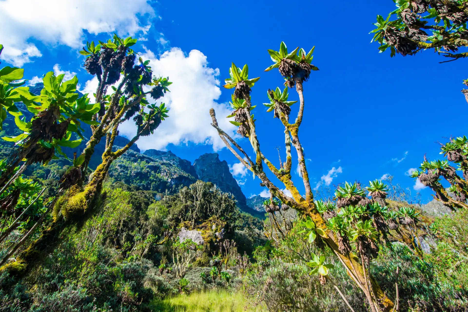
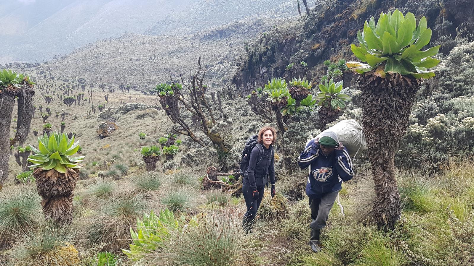
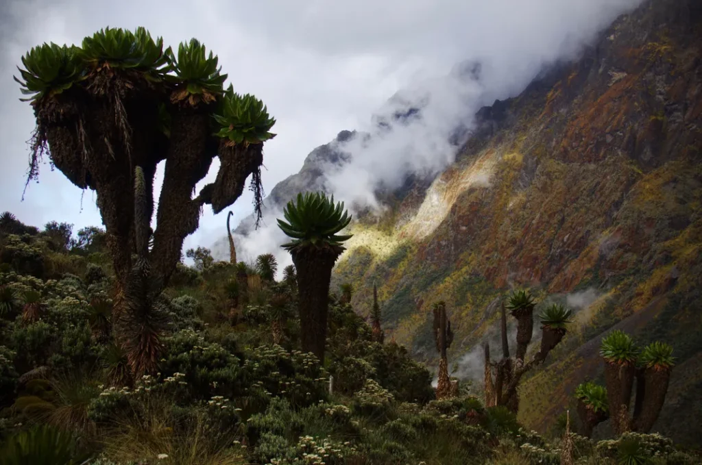
Day 3 is where the Rwenzori’s legendary alpine vegetation reaches its full expression. From John Matte, the trail climbs through increasingly open heathland into the full afro-alpine zone, where giant groundsels (Senecio adnivalis) emerge from the mist like botanical sculptures, and giant lobelias (Lobelia wollastonii) rise on columnar stalks from the bog margins. These plants found nowhere else on Earth at this altitude have adapted to the extreme diurnal temperature range of equatorial mountains: night frosts followed by intense daytime solar radiation. They are the Rwenzori’s most iconic sight and the subject of virtually every photograph that has ever made a trekker want to visit them. Our vegetation zones guide provides a full botanical breakdown.
The trail descends from the heathland into the Lake Bujuku basin, one of the most celebrated landscapes in all of African mountaineering. Lake Bujuku (3,977 m) is a shallow glacial tarn fringed by bog and giant groundsel, reflecting the snow slopes of the Mount Stanley massif above when the cloud clears. The scene is primordial and primeval and entirely unlike anything the Rwenzori’s forest zones prepare you for. Arriving at the lake in morning light, mist burning off the water, and a groundsel catching the early sun is the kind of moment that justifies transcontinental travel.
Bujuku Camp, at 3,977 m, is the highest camp on the classic Central Circuit and the last stop before the high passes. The huts here are basic but sturdy; the facilities are functional. Altitude effects are very real at Bujuku: headaches, disrupted sleep, and reduced appetites are common. Your guide will monitor your acclimatization closely. Drink water, eat what you can, and sleep as much as possible.
Highlights: Giant groundsel and giant lobelia zones, Lake Bujuku reflection views of Mount Stanley, and first experience of the full Afro-alpine world.
Sleep: Bujuku Camp (3,977 m) trail huts, shared facilities; a warm sleeping bag essential
Day 4: Bujuku Camp → Scott Elliott Pass → Kitandara Camp
Elevation: 3,977 m → 4,372 m → 4,023 m | Distance: ~7 km | Hiking Time: 5–7 hours
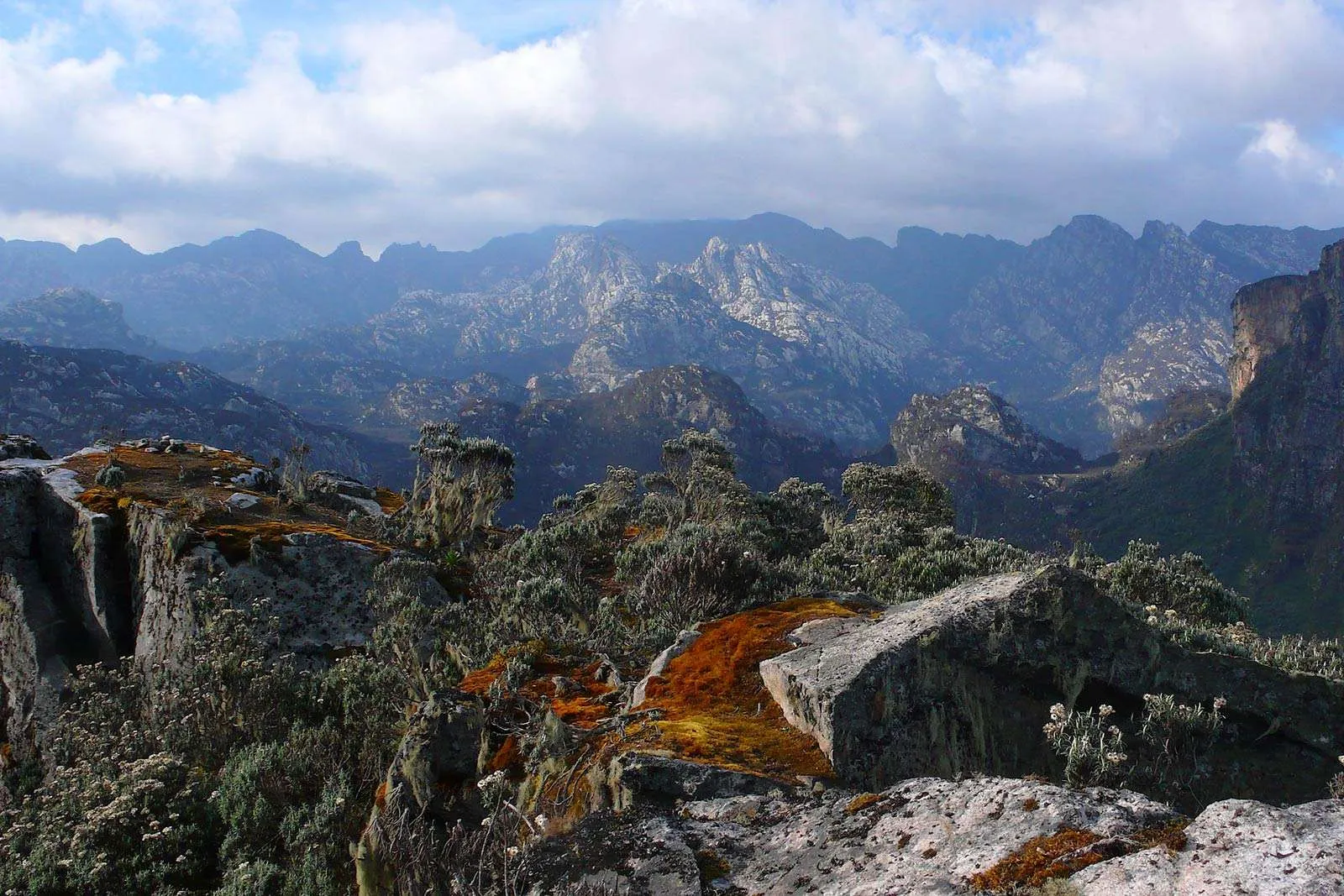
Day 4 is the most visually dramatic hiking day of the 7-Day Mount Emin Trek. From Bujuku, the trail climbs steeply to Scott Elliott Pass at 4,372m the key col between the Stanley massif to the north and the Emin-Gessi group to the south. The ascent to the pass is steep and often slippery on wet rock, gaining nearly 400 metres in less than 2 kilometers. At the pass itself, the world opens up in two directions simultaneously: to the north, the ice walls of the Elena Glacier on Mount Stanley are visible above; to the south, the immense valley of the Kitandara Lakes stretches out below. This location is one of the great mountain viewpoints in Africa.
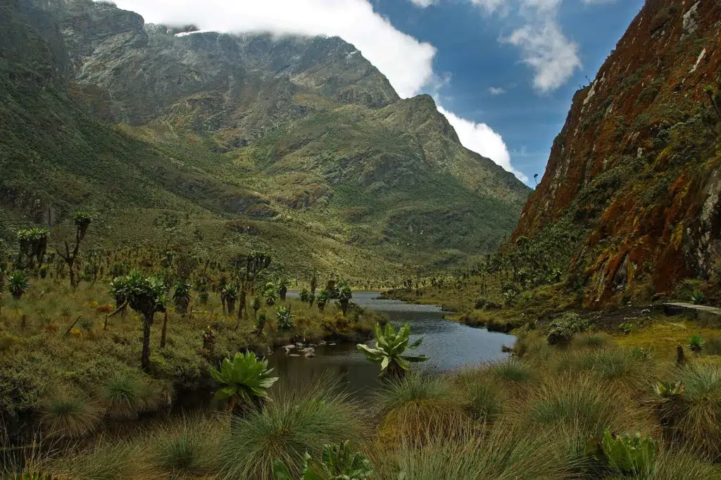
The descent from Scott Elliott Pass to the Kitandara basin is technically easier than the ascent but demands attention to loose rock in dry conditions and slick mudstone after rain. The path drops through increasingly lush vegetation as the elevation falls back to 4,000m: giant groundsels yield way to mossy banks and the first Afro-alpine grasses. The twin Kitandara Lakes (Upper at 4,023m, Lower slightly below) come into view as the trail levels two deep glacial tarns of extraordinary clarity, ringed by flat bog and overtopped by the rocky buttresses of Mount Emin to the east. The reflected sky in the water on a clear afternoon is one of the Rwenzori’s most extraordinary photographic subjects.
Kitandara Camp at 4,023m is positioned on a flat bench above the upper lake. This location is your base for the summit attempt the following morning. The camp is more exposed than the valley huts below, where the wind can be significant and overnight temperatures frequently drop below -5°C. Your summit gear should be laid out and checked this evening; your guide will brief you on the Day 5 route and conditions after dinner. Sleep as early as possible: a 5:00 AM departure is standard for summit day.
Highlights: Scott Elliott Pass panorama (Stanley glacier + Kitandara basin), Kitandara Lakes reflection photography, evening Mount Emin skyline from camp
Sleep: Kitandara Camp (4,023 m) trail huts; sleeping bag rated -10°C recommended for summit night
Day 5: Summit Day — Kitandara Camp → Umberto Peak (4,798 m) → Kitandara Camp
Elevation: 4,023 m → 4,798 m and return | Distance: ~8 km return | Hiking Time: 7–10 hours
Summit day on the 7-Day Mount Emin Trek is an early, cold, and technically demanding affair that rewards every step with panoramic views of increasing magnificence. Departure from Kitandara Camp is at 5:00 AM, in darkness, with headtorches on. The pre-dawn start serves two purposes: reaching the summit before the afternoon cloud builds and completing the rocky upper sections while the rock is dry and firm rather than wet with morning condensation.
The route to Umberto Peak (4,798m) from Kitandara climbs the southeastern ridge of the Emin massif. The lower section crosses open bog and scree before reaching the rockier terrain above 4,400m. Above 4,500m, the summit ridge narrows, and the scrambling becomes sustained hands-on rock, careful footwork, and exposure on the right side. This is not technical climbing in the glacier sense, but it demands confidence on steep rocky ground, sure footing, and no fear of heights. Your guide will be with you on the most exposed sections. Crampons are not typically required for Umberto Peak unless there has been recent snowfall; your guide will assess the conditions on the morning of your hike.
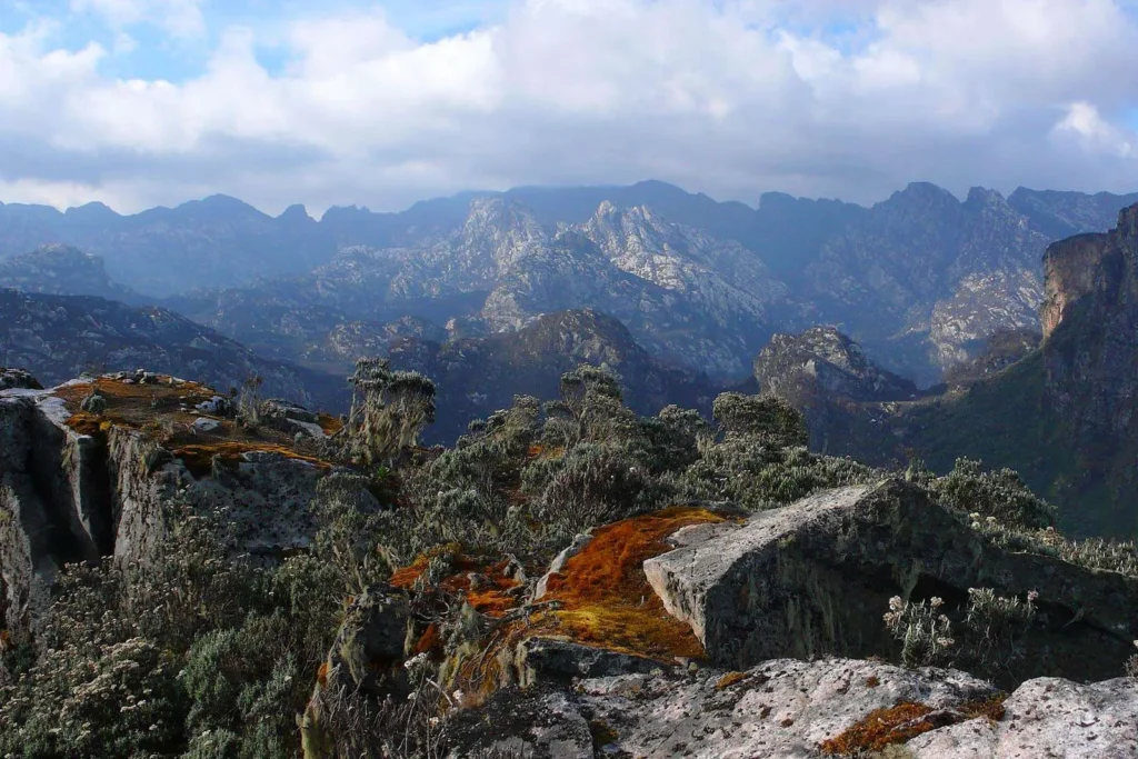
The summit of Umberto Peak at 4,798m is a narrow rocky crown with vertiginous drops on multiple sides and views that span the entire southern Rwenzori. To the west, you look directly down at the Kitandara Lakes, impossibly blue and flat from 775 metres above. To the north, the snow dome of Mount Stanley dominates the skyline at 5,109m. To the south, the ridge of Mount Gessi (4,715m) runs parallel, its Bottego Peak clearly visible. To the east, the broad highland plateau falls away toward the Albertine Rift and the plains of central Africa. Across the border, the hills of DR Congo are visible on a clear morning. This is a summit view that very few people on Earth have ever witnessed.
Return to Kitandara Camp by the reverse of the ascent route. A late lunch is served on return, followed by an afternoon of rest and altitude recovery. The descent from Umberto Peak back to camp takes 3–4 hours. Your body will be exhausted; let it rest. Day 6 is a long descent day, and your legs will need everything they have.
Summit: Umberto Peak, 4,798m south ridge scramble; no glacier crossing required
Sleep: Kitandara Camp (4,023m) second night; recovery rest
Day 6: Kitandara Camp → Guy Yeoman Camp (3,261m)
Elevation: 4,023 m → 3,261 m | Distance: ~9 km | Hiking Time: 5–6 hours
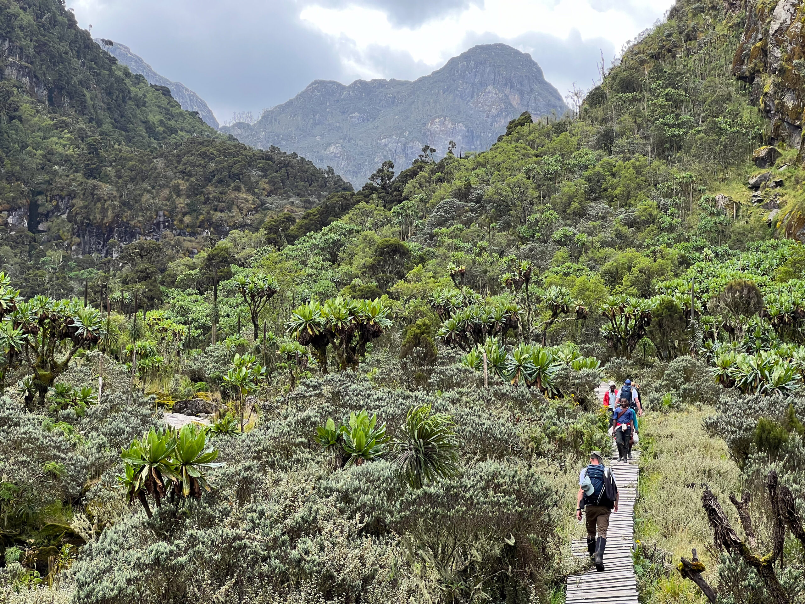
Day 6 begins the circuit’s return arc, descending from the Kitandara basin via the Guy Yeoman route through the southwestern arm of the Central Circuit. Leaving the lakes behind, the summit of Emin above the trail traverses a long ridge section before beginning the descent through the vegetation zones in reverse. The botanical transition on the way down is, if anything, more vivid than on the ascent: you re-enter the giant heather tunnels from above, watch the groundsels shrink behind you, and feel the air thicken and warm as elevation drops.
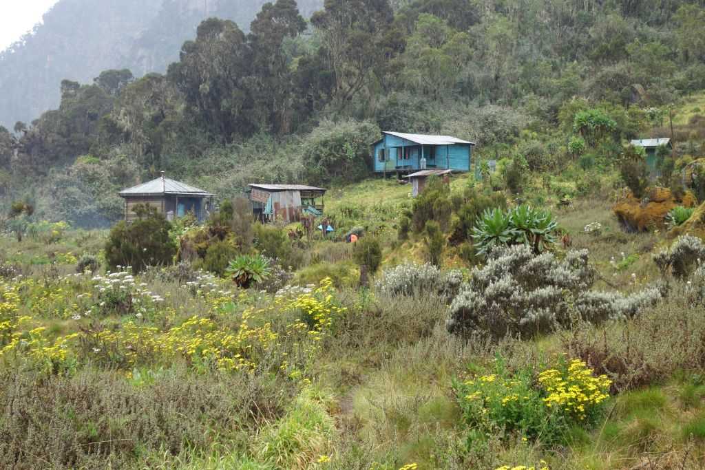
The descent passes through the Freshfield Pass area before dropping steadily to Guy Yeoman Camp at 3,261m. This camp is positioned on a wide plateau above the Mubuku Valley, with sweeping views back toward the central Rwenzori massif. Named for British explorer Major Charles Granville Bruce’s surveyor, Guy Yeoman, the camp marks the midpoint of the return and serves as the final night in the true high-altitude zone. The surrounding vegetation of tree heather, hagenia, and the first returning montane species makes for a gentler, warmer camp atmosphere than Kitandara or Bujuku.
This evening your guide team will conduct a final mountain debrief reviewing the summit, discussing the descent route, and allowing time for questions about the Rwenzori’s ecology and history. It is, for many trekkers, one of the most appreciated evenings of the entire trip.
Highlights: Descent through full Afro-alpine sequence, Freshfield Pass views, warm camp atmosphere at Guy Yeoman
Sleep: Guy Yeoman Camp (3,261m) hut accommodation, shared facilities
Day 7: Guy Yeoman Camp → Nyakalengija Trailhead (Final Descent)
Elevation: 3,261m → 1,646m | Distance: ~9 km | Hiking Time: 5–6 hours
The final day of the 7-Day Mount Emin Trek is a long descent through the lower forest zones back to the Nyakalengija Trailhead. From Guy Yeoman, the trail drops steadily through the heather-to-bamboo transition, then into the dense montane forest, finally emerging at the trailhead with a net descent of nearly 1,600 metres over 9 kilometers. Trekking poles are essential; your quads and knees will be working hard.
The forest on the descent is a different experience from the upward journey: familiar terrain seen with summit eyes. The colobus monkeys and hornbills that greeted you on Day 1 reappear; the air thickens, the temperature rises, and the smell of forest vegetation returns after days of high-altitude mineral landscape. Crossing the Mubuku River log bridge a final time feels ceremonial. The trailhead, when it appears, is a bittersweet sight.
Your lead guide presents a completion certificate at the Nyakalengija gate. Your vehicle transfers you back to Kasese. Kasese travel guide offers a hot shower, a cold drink, and the satisfaction of knowing you have climbed one of the most rarely summited peaks in Africa. For those who want to go further, our 13-Day 6 Peaks Expedition incorporates Mount Emin alongside five other Rwenzori summits.
Highlights: Final Mubuku River crossing, forest re-entry, colobus monkey sightings, completion certificate at Nyakalengija gate
End point: Nyakalengija Trailhead (1,646 m); vehicle transfer to Kasese arranged as standard
Elevation Profile Summary: 7-Day Mount Emin Trek
The 7-Day Mount Emin Trek follows a circuit with a maximum summit elevation of 4,798m (Umberto Peak on Day 5) and a starting/ending elevation of 1,646m (Nyakalengija). Total cumulative elevation gain across all seven days is approximately 3,800m, with approximately 3,800m of descent.
Day 1: 1,646m → 2,652m | +1,006m over 8km. The route features a sustained forest climb with no significant descent sections.
Day 2: 2,652m → 3,414m | +762m over 8km. The trail passes through bamboo and giant heather zones, with some undulation.
Day 3: 3,414 m → 3,977 m | +563m over 7 km. Afroalpine zone entry; bog crossings slow progress more than elevation.
Day 4: 3,977 m → 4,372 m (Scott Elliott Pass) → 4,023 m | net +46m with 745 m of combined vertical over 7 km. The pass descent to Kitandara is steep and demands care.
Day 5 (Summit): 4,023 m → 4,798 m → 4,023 m | +775 m up / -775 m return over ~8 km total. Summit ridge scramble from ~4,500 m.
Day 6: 4,023 m → 3,261m | -762 m over 9 km. On a long descent, the vegetation zones appear in reverse order.
Day 7: 3,261 m → 1,646 m | -1,615 m over km. Most knee-intensive descent of the trek; poles are essential.
Camps & Accommodation on the 7-Day Mount Emin Trek
Nyabitaba Camp: 2,652 m
The Central Circuit’s first overnight camp, perched on a wide ridge above the Mubuku Valley. Wooden huts with foam mattresses, a toilet block, and a cooking shelter. The ridge-top position offers the trek’s first open views across the Albertine Rift. Temperatures here are 12–18°C; a light fleece is sufficient for evenings.
John Matte Camp, 3,414 m
Set in a clearing of the giant heather zone, John Matte is a well-established camp with sturdy huts and some of the best mountain views accessible from any accommodation on the Central Circuit. The camp sits just below the altitude threshold at which most trekkers first notice the mild effects of altitude. Temperatures drop to 5–10°C at night; your insulating mid-layer becomes essential here.
Bujuku Camp, 3,977 m
The highest-elevation camp on the standard Central Circuit. Positioned at the northern end of the Lake Bujuku basin, the camp huts have a direct view across the tarn toward the snow-clad upper ridges of Mount Stanley. At nearly 4,000m, Bujuku is where acclimatization becomes a real physiological process, not just a precaution. Cold, damp, and occasionally blustery; a sleeping bag rated to -10°C is recommended for this night.
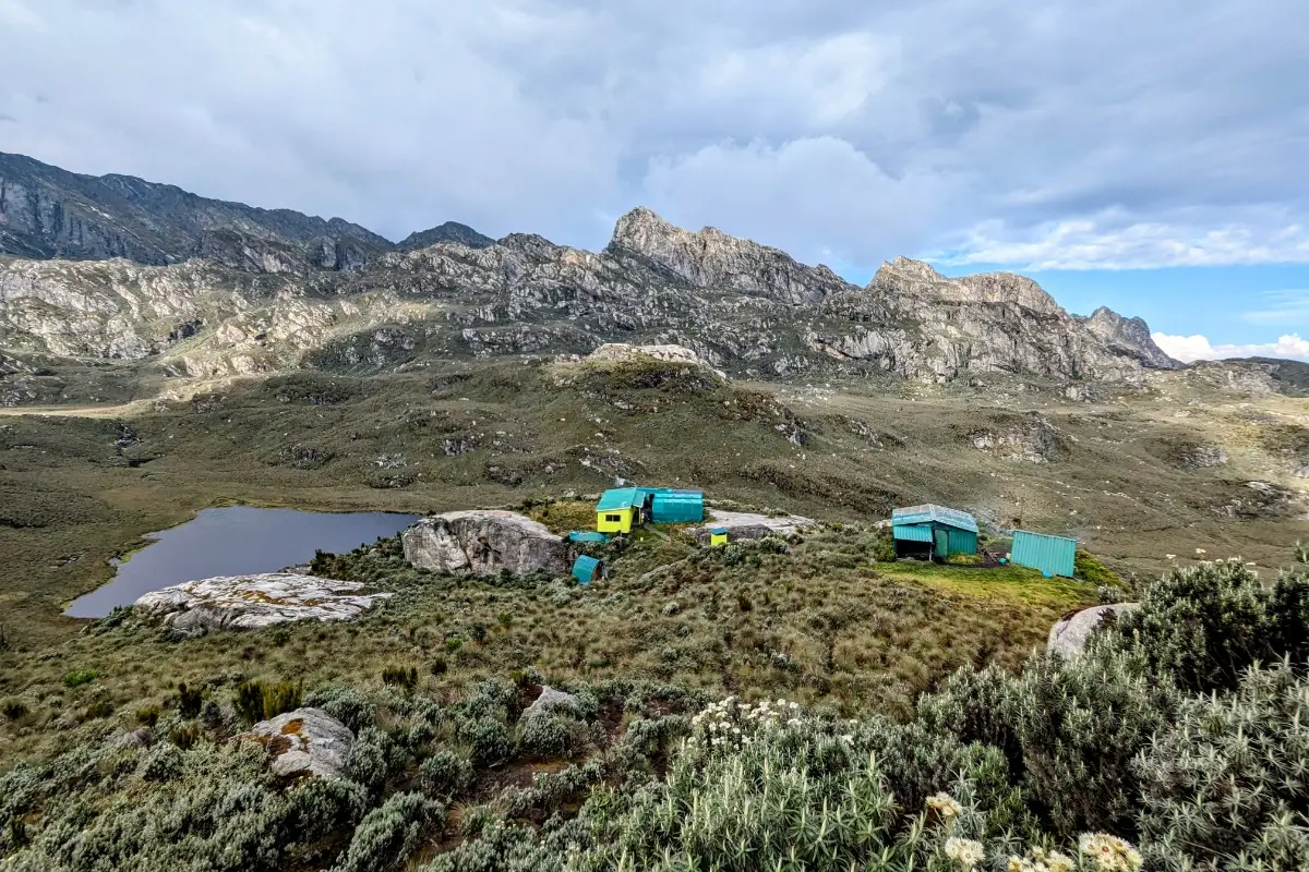
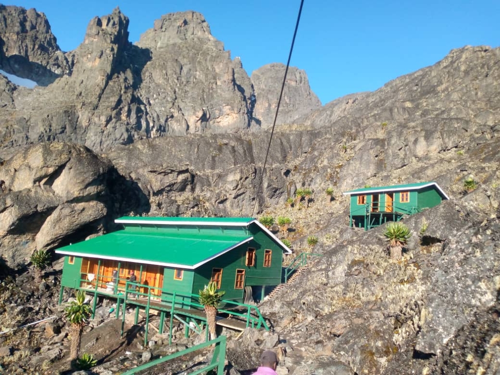
Kitandara Camp, 4,023 m (2 nights: Days 4 & 5)
Your highest sleeping point on this itinerary and the base camp for the Mount Emin summit attempt. Positioned above the Upper Kitandara Lake in the lee of a rocky ridge, the camp enjoys extraordinary views of the lake basin and the surrounding peaks, including Mount Emin’s rocky summit ridge, clearly visible to the east. The camp is well-maintained for its altitude but is genuinely cold and wind-exposed. The Kitandara Lakes below the camp are among the most photographed landscapes in all of Rwenzori trekking.
Guy Yeoman Camp, 3,261 m
Named for a surveyor from the early 20th-century exploration era, Guy Yeoman Camp occupies a broad plateau position above the Mubuku Valley on the Central Circuit’s return arm. The lower elevation means meaningfully warmer temperatures (8–14°C at night) and a return to the visual texture of the heather zone after the stark Afroalpine world above. Many trekkers find their best sleep of the entire expedition here; altitude effects are reduced, post-summit satisfaction is high, and the end is finally in sight.
Flora & Wildlife on the 7-Day Mount Emin Trek
The Central Circuit passes through all five of the Rwenzori’s vegetation zones over seven days, delivering the most complete botanical and wildlife transect available on any single trekking itinerary in the range. Our full vegetation zones guide and Rwenzori wildlife guide provide complete species listings for each zone.
Montane Forest Zone (1,646 m–2,500 m) Days 1 & 7
The trail enters and exits through the Afromontane rainforest dominated by Podocarpus milanjianus, Hagenia abyssinica, and Symphonia globulifera. People regularly encounter black-and-white colobus monkeys, red-tailed monkeys, L’Hoest’s monkeys, and blue monkeys. The Rwenzori turaco, the African green broadbill, and multiple sunbird species are the avian highlights. Three-horned Jackson’s chameleons are frequently spotted on low-level vegetation. Forest duikers are occasionally seen at dawn and dusk.
Bamboo Zone (2,500 m–2,800 m) Day 2
A transitional belt of Arundinaria alpina bamboo, associated with forest elephants and buffalo. Trail evidence of elephant passage, broken bamboo, and bark scoring is common even where the animals themselves are not seen. This zone is typically passed quickly on Day 2 but represents an important habitat corridor between forest and heathland.
Giant Heather Zone (2,800 m–3,500 m): Days 2 & 3
Erica arborea and Erica trimera grow to towering heights here, draped in old man’s beard lichen (Usnea) that imparts the tunnels their characteristic silver-grey color. Ground orchids appear at the bog margins. Duikers are occasionally seen in open glades. Birdwatchers encounter Rwenzori-specific bird species, including the handsome spurfowl, in this zone.
Afro-alpine Zone (3,500 m–4,500 m) Days 3, 4, 5, & 6
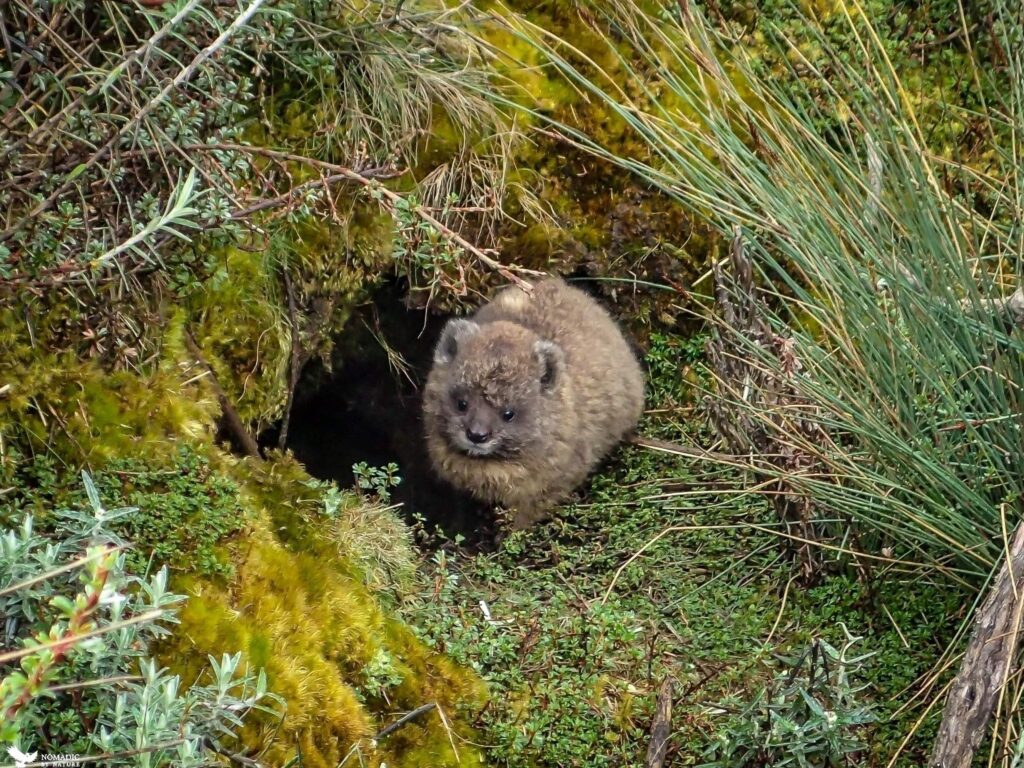
The most visually distinctive zone of the trek is the one that stands out the most. Giant groundsels (Senecio adnivalis) and giant lobelias (Lobelia wollastonii) are the defining botanical features; these are Gondwanan relict species found on only a handful of equatorial African mountains. The Kitandara Lakes area within this zone is a critical habitat for the Rwenzori otter, occasionally seen at the lake margins. Klipspringers are spotted on rocky outcrops near the Emin ridgeline.
Nival Zone (4,500 m+): Day 5 Summit
Above 4,500m on the Umberto Peak ridge, vegetation disappears almost entirely. Bare rock, scree, and occasional lichen represent the upper limit of plant life in the Rwenzori. The summit environment is geological and silent: wind, rock, and sky. Glacial relict features are visible on the upper Emin ridgeline, including polished rock surfaces and moraine debris from the glaciers that covered these peaks as recently as the early 20th century. Read more about the Rwenzori glacier retreat to understand the historical scale of the ice that once covered this summit.
Physical Difficulty & Fitness Requirements for the 7-Day Mount Emin Trek
The 7-Day Mount Emin Trek is rated Strenuous and is not suitable for trekkers without a solid base of high-altitude or mountain hiking experience. The combination of sustained high elevation (three nights above 3,900m), a technical summit scramble to 4,798m, and the cumulative physical demands of a 7-day alpine circuit makes this trek genuinely demanding. It is appropriate for experienced hikers who regularly complete multi-day mountain treks, have spent time above 3,500m, and are in excellent cardiovascular condition.
The summit scramble to Umberto Peak (4,798m) involves sustained rocky terrain above 4,500m, with exposed sections requiring three-point contact and confidence on steep ground. This route is not glaciated climbing; no crampons, rope, or ice axe is typically required, but it demands more than trail walking. Prior experience of rocky mountain ascents at altitude (Kilimanjaro, Mont Blanc approaches, and alpine hiking at 4,000 m+) is strongly recommended. For an honest assessment of whether your fitness level is appropriate, our fitness and training guide, as well as our guide to how hard Rwenzori trekking really is, are required reading before booking.
Training in the 8–12 weeks before departure should include regular uphill hiking with a weighted pack (12–15kg), stair-climbing sessions, cardiovascular base training (running or cycling 4–5 days per week), and ideally at least one multi-day hiking trip above 2,500m in the month before departure. The itinerary’s pacing includes an altitude acclimatization strategy, but personal resilience at altitude varies considerably. Consult your physician and consider a prescription for Diamox if you have previously experienced altitude sickness. Our guides carry emergency medications and are trained in altitude illness recognition. For trekkers over 50, our dedicated guide to hiking the Rwenzori as an older trekker addresses specific preparation considerations.
Best Time to Climb Mount Emin: Seasons & Conditions
Choosing the right season for the 7-Day Mount Emin Trek is especially important given the technical nature of the summit day. Summit conditions on the Umberto Peak ridge, where wet rock is significantly more dangerous than dry rock, make seasonal planning a genuine safety consideration rather than merely a comfort preference.
June to August (Long Dry Season) is the best overall period.
Trails are at their most stable, the summit ridge rock is dry and grippy, the views from Scott Elliott Pass and Umberto Peak are most likely to be clear, and Kitandara Lakes’ reflection photography is at its best in the June dawn light. This period is the preferred window for summit expeditions. Book 3–6 months in advance for this period.
December to February (Short Dry Season) is excellent.
December and January offer the best of the short dry season and are nearly as reliable as the June–August window. The pre-short-rains period can leave the upper mountain in excellent condition. Kitandara Lakes often carry more water and are more dramatically filled than in the dry season proper.
March to May & September to November (Wet Seasons): Not Recommended for Summit:
The summit ridge of Umberto Peak becomes significantly more dangerous in wet conditions: wet basalt and loose rock under rain. Lower trail sections become deeply muddy, and river crossings may be high. Experienced trekkers can complete the circuit without summiting in these months, but we do not recommend the Umberto Peak attempt in the wet season. If your dates are fixed in a wet-season window, consider the 7-Day Margherita Peak Climb as an alternative; the Stanley glacier approach has different risk characteristics in wet conditions.
What’s Included & What’s Not Included
Included
- Uganda Wildlife Authority Entry Permit 7 days of park access fees (USD 315 per person)
- Professional Lead Guide: UWA-certified and highly experienced on Central Circuit and Mount Emin summit approach
- Assistant Guide: second certified guide for summit day safety management
- Dedicated Porter Team: one porter per trekker for luggage up to 15kg
- Camp Cook & Full Board breakfast, trail lunch/snacks, and 3-course dinner daily
- 6 Nights Camp Hut Accommodation Nyabitaba, John Matte, Bujuku, Kitandara (×2), Guy Yeoman
- Pre-Departure Safety Briefing full route, summit approach, and emergency protocol overview
- Emergency First Aid Kit pulse oximeter, Diamox, altitude medications, wound care
- Completion Certificate issued at Nyakalengija Trailhead on successful return
- Kasese ↔ Nyakalengija Transfer included on Day 1 and Day 7
Not Included
- International & Domestic Flights to Kasese: transfers are arrangeable on request
- Personal Technical Gear boots, sleeping bag, trekking poles, crampons (if required)
- Travel Insurance with Emergency Evacuation mandatory; helicopter evacuation coverage essential
- Gratuities for guides, porter team, and cook (see FAQ for recommendations)
- Personal Snacks & Alcoholic Beverages
- Kasese Accommodation pre/post-trek nights in Kasese; we can recommend and arrange
Packing & Gear List for the 7-Day Mount Emin Trek
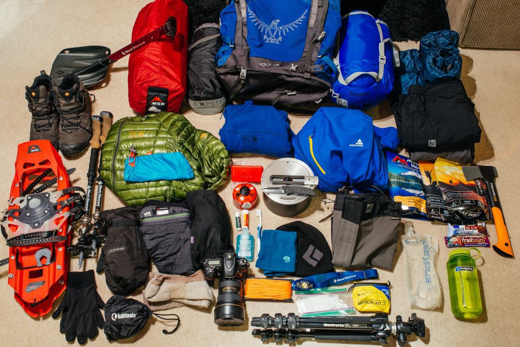
Our full Rwenzori packing guide covers every item in detail. Below is the essential list specific to the 7-day / summit conditions of the Mount Emin itinerary.
Footwear
- Waterproof mountaineering boots with ankle support stiff sole essential for summit ridge scrambling; DWR treated before departure
- Crampons bring lightweight aluminium crampons as contingency; guide will advise on the morning of Day 5
- Gaiters essential from John Matte upward; keep out snow, scree, and bog water
- Rubber gumboots available to hire in Kasese; they are invaluable for lower trail mud (Days 1, 2, 7)
- Camp sandals: lightweight footwear for evenings in camp huts
Clothing Layering System
See our guide to staying warm on the Rwenzori summit for detailed layering advice for high-altitude Rwenzori conditions.
- Thermal base layer (top & bottom): merino wool preferred; brings 2 sets
- Insulating mid-layer 600-fill down jacket or synthetic equivalent; essential at Kitandara (-5°C nights)
- Heavyweight fleece secondary insulation layer for summit day; worn under the shell jacket above 4,500m
- Waterproof shell jacket non-negotiable; must be fully sealed with taped seams
- Waterproof shell trousers, lightweight but fully sealed; worn from John Matté upward
- Summit gloves: warm insulated gloves + lightweight liner gloves for precise grip on summit rocks
- Balaclava or heavyweight warm hat summit mornings at 4,798m can reach a wind chill of -15°C
- Sun hat & glacier goggles: UV intensity above 4,000m is extreme; eye protection essential
- 4+ pairs of merino or wool socks; do not use cotton at altitude
Sleep System
- Sleeping bag rated to -10°C comfort rating; Kitandara Camp sees -5°C to -8°C regularly at night
- Sleeping bag liner adds 5°C and protects camp bedding
Equipment
- Trekking poles (pair), collapsible; essential for Day 7 descent; fold away for summit scramble
- Daypack 30–40L carries summit gear, water, and emergency layers; the main pack is carried by the porter.
- Water bottles / hydration bladder with a minimum 2L capacity; bladder tubes freeze above 4,500m in early morning; use bottles on summit day
- Headtorch + spare batteries: summit departure is 5:00 AM in darkness; lithium batteries for cold-weather performance
- Dry bags all electronics, sleeping bag, and spare clothes in waterproof bags inside main pack
Health & Safety
- Diamox (Acetazolamide): consult physician before departure; reduces altitude sickness risk above 3,500m
- Personal first aid: ibuprofen, loperamide, rehydration salts, blister kit, antiseptic
- Sunscreen SPF 50+: UV radiation at 4,798m is severe; reapply every 2 hours
- Lip balm with SPF altitude air is extremely dry; sunburned lips are a common and avoidable nuisance
Permits, Park Fees & Cost Breakdown
All UWA park fees and accommodation costs are included in the Rwenzori Trekking Safaris package price. The fee structure per person for the 7-day trek is as follows:
| UWA Entry Permit | USD 45 per person per day × 7 days = USD 315 |
| UWA Hut Accommodation | USD 30 per person per night × 6 nights = USD 180 |
| Professional Lead Guide | Included in package price |
| Assistant Guide (summit day support) | Included in package price |
| Porter Team (1 per trekker, 15kg limit) | Included in package price |
| Camp Cook & Full Board Meals | Included in package price |
| Nyakalengija Trailhead Transfers | Included in package price |
| Emergency First Aid Kit | Included in package price |
| Recommended Guide Gratuities | Guide: USD 80–100 | Porter: USD 50–70 | Cook: USD 50–60 |
| Total UWA Fees (per person) | USD 495 (entry + accommodation) is fully included in the package. |
For current package pricing by group size, contact us. Solo and duo trekkers are welcome. Groups of 6+ receive the most favorable per-person rates. For a full cost-of-trek breakdown including flights, gear, and incidentals, see our full Rwenzori cost guide.
Getting to the Nyakalengija Trailhead: Transport & Logistics
The Nyakalengija Trailhead is located approximately 22km northeast of Kasese town, near the village of Ibanda in western Uganda. Our comprehensive Kasese gateway guide for trekkers covers accommodation, dining, and day-of-arrival logistics. For complete transport options from across Uganda, see our guide on getting to the Rwenzori.
From Kampala
Kampala to Kasese is approximately 385 km, 5–6 hours by private vehicle or 6–8 hours by bus (Gateway, Link, and other operators run daily services). We recommend private 4WD transfers for trekking groups with equipment, approximately USD 120–150 one-way, arranged through Rwenzori Trekking Safaris. Allow a full travel day and plan to stay overnight in Kasese before your Day 1 trek starts.
From Entebbe International Airport
Entebbe to Kasese is approximately 420km (5.5–7 hours). All international arrivals at Entebbe should plan to overnight in Kampala or Entebbe after landing and begin their westward journey the following morning. Budget two full travel days between international arrival and trek start if you cannot guarantee a prompt Entebbe connection.
Kasese to Nyakalengija Trailhead
The 22km transfer from Kasese town to the Nyakalengija trailhead takes approximately 35–45 minutes by vehicle on mixed tarmac and dirt road. We include this transfer in all 7-day packages as part of your Day 1 departure logistics. Permit verification and final pack checks take place at the Nyakalengija gate before the trail begins.
Book Your Slot
Respond within Minutes
From
$1,200
per person
- Duration 7 Days / 6 Nights
- Group Size 1–12 people
- Start Point Nyakalengija
- Departures Year-round
- Summits Umberto Peak
No booking fee. Free cancellation up to 30 days before departure. We respond within Minutes.
Explore Related Rwenzori Treks
Magheritah Peak (8 Days Kilembe Trail)
$1705 Per Person
Mutinda LookOut (4 Days)
$645 Per Person
Short Magherita Hike (5 Days Central Circuit)
$1200 Per Person
Rwenzori Hike (7 Days Central Circuit)
$1400 Per Person
Frequently Asked Questions: 7-Day Mount Emin Trek
How difficult is the 7-Day Mount Emin Trek for an experienced hiker?
The 7-Day Mount Emin Trek is rated Strenuous and is specifically designed for experienced trekkers with prior high-altitude hiking experience. The summit scramble to Umberto Peak (4,798m) involves sustained rocky terrain above 4,500m, with exposed sections requiring confidence on steep ground and three-point contact technique. Three nights above 3,900m make this a genuine high-altitude expedition. Trekkers who have completed Kilimanjaro, multi-day alpine hiking above 3,500m, or similar high-altitude experiences will find this appropriately challenging. First-time high-altitude trekkers should consider starting with our 7-Day Margherita Peak trek and returning for Emin with that experience base.
What is the summit elevation of Mount Emin and how does it compare to other Rwenzori peaks?
Mount Emin’s highest point, Umberto Peak, stands at 4,798m above sea level, making it the fifth highest peak in the Rwenzori Mountains. It is lower than Mount Stanley (5,109m), Mount Speke (4,890m), and Mount Baker (4,843m), but higher than Mount Gessi (4,715m) and Mount Luigi di Savoia (4,627m). It is also lower than the Rwenzori’s highest point, Margherita Peak, at 5,109m but unlike Margherita, the Emin summit approach does not involve glacier crossing, making it the most technically accessible of the range’s higher peaks while still delivering a genuine high-altitude mountain experience.
Is the Mount Emin summit climb more difficult than Margherita Peak?
The Umberto Peak summit on Mount Emin is technically different from but not necessarily easier than the Margherita Peak ascent via the Elena Glacier. Margherita requires glacier travel with crampons and an ice axe; Emin involves a sustained rocky ridge scramble above 4,500m that is more demanding in terms of physical exposure and scrambling technique. Emin is generally considered the more appropriate first Rwenzori summit for trekkers with scrambling experience but limited glacier experience. Margherita is more physically straightforward once on the glacier but requires additional technical equipment and confidence on ice.
Do I need crampons and an ice axe for the 7-Day Mount Emin Trek?
Crampons and an ice axe are not typically required for the standard Umberto Peak ascent on the 7-Day Mount Emin Trek. The summit approach is a rocky ridge scramble that does not involve glacier crossing under normal dry-season conditions. However, bring lightweight aluminum crampons as a contingency; your guide will assess summit conditions on the morning of Day 5, and if there has been recent snowfall or ice on the upper ridge, crampons will significantly improve both safety and speed. Your guide will provide definitive advice on the day. Ice axes are not required on this route.
What altitude sickness risk should I expect on the 7-Day Mount Emin Trek?
The 7-Day Mount Emin Trek involves three consecutive nights above 3,900 m (Bujuku at 3,977 m and Kitandara at 4,023 m for two nights) and a summit day reaching 4,798 m. You should expect altitude-related symptoms at these elevations rather than fear them. Mild symptoms, such as headache, fatigue, reduced appetite, and disrupted sleep, typically appear at Bujuku or John Matté and often resolve with the body’s natural acclimatization by Day 4. Serious altitude sickness (HACE or HAPE) is rare but possible; our guides are trained to recognize and respond to these conditions. The standard preventive protocol is hydration (3–4 liters per day), steady pacing, avoiding alcohol above 3,000m, and the optional use of Diamox (consult your physician before departure).
How many people have climbed Mount Emin? How rare is this summit?
Mount Emin is one of the least climbed significant peaks in Africa. The entire Rwenzori range across all its routes and peaks receives fewer than 1,000 trekkers per year. Mount Emin, as a non-standard objective outside the Margherita Peak circuit, sees only a fraction of that number, estimated annually in the dozens per year. For context, Kilimanjaro receives over 50,000 trekkers per year. Standing on Umberto Peak at 4,798m places you in a remarkably exclusive category of mountaineers globally. This exclusivity is one of the primary reasons serious trekkers choose the Rwenzori over more commercially popular African peaks.
Can I combine the 7-Day Mount Emin Trek with a climb of Margherita Peak?
Yes. Mount Emin and Margherita Peak can be combined on the same expedition, typically over 10–13 days. Our 10-Day 4 Peaks Trek and 13-Day 6 Peaks Expedition both include Mount Emin as part of larger peak-bagging circuits. These extended expeditions follow a similar Central Circuit base route with detours to multiple summit groups and are appropriate for highly experienced, fit trekkers with at least 12–15 days available.
What is the Kitandara Lakes, and why is it significant on the Mount Emin Trek?
The Kitandara Lakes are a pair of glacially formed alpine tarns at approximately 4,023m in the southwestern quadrant of the Rwenzori range. Upper Kitandara and Lower Kitandara sit in a broad glacial basin below the rocky ridgelines of the Emin-Gessi massif, fed by meltwater and rainfall. The lakes are among the most photographed landscapes in the Rwenzori Mountains; their extraordinary clarity and the reflection of the surrounding peaks create images that are immediately recognizable to anyone familiar with Rwenzori photography. For the 7-Day Mount Emin Trek, Kitandara serves as the base camp for the summit attempt. The camp above the lake offers one of the most remarkable overnight positions in African trekking.
What food will I eat during the 7-Day Mount Emin Trek?
All meals are prepared by your dedicated camp cook from Day 1 through Day 7. Breakfasts include porridge, eggs (boiled or scrambled), toast, fruit, and tea or coffee. Trail lunches are packed boxes with sandwiches, fruit, energy bars, crackers, and juice. Dinners are hot three-course meals: a soup starter, a main course of rice, pasta, or posho with beans, vegetables, and protein (chicken, beef, or fish depending on supply), followed by a fruit dessert. On summit day (Day 5), a high-energy pre-dawn breakfast is provided before the 5:00 AM departure. Vegetarian, vegan, and gluten-free requirements can be accommodated with advance notice at booking.
What is the best way to train for the 7-Day Mount Emin Trek?
Training for the 7-Day Mount Emin Trek should begin 8–12 weeks before departure. The most effective preparation includes weekly uphill hiking sessions with a weighted pack (12–15kg) of at least 3–5 hours’ duration; cardiovascular base training (running or cycling) 4–5 days per week; stair-climbing sessions for knee strength and endurance; and ideally at least one multi-day hiking trip above 2,500m in the 4–6 weeks before departure. For comprehensive training protocols specific to Rwenzori altitude conditions, our Rwenzori fitness and training guide is the definitive preparation resource.
Is the 7-Day Mount Emin Trek suitable for beginners?
The 7-Day Mount Emin Trek is not appropriate for trekking beginners. The combination of 7 days at altitude, three nights above 3,900m, and a technical rocky summit scramble to 4,798m requires genuine mountaineering experience and a strong physical base. First-time Rwenzori trekkers and those new to high-altitude trekking should consider our beginners’ guide to climbing the Rwenzori and then consider starting with the 4-Day Rwenzori Waterfalls Hike or 7-Day Margherita Peak Climb as a first Rwenzori expedition.
Ready to Claim Umberto Peak?
Mount Emin is one of the rarest high-altitude summits in Africa. Join the tiny circle of trekkers who have stood on Umberto Peak and looked out over the Kitandara Lakes at 4,798 metres. Departures are strictly limited; start your booking conversation today.
Email: rwenzoritrekkingsafaris@gmail.com
WhatsApp / Phone: +256 773256104