Complete guide to the 4-day Rwenzori trek to Mutinda Lookout (3,975 m) via the Kilembe Trail. Full itinerary, camps, wildlife, gear, costs & 10+ FAQs. From $645

4-Day Rwenzori Trek to Mutinda Lookout via Kilembe Trail | Complete Guide
Overview of the 4-Day Rwenzori Trek to Mutinda Lookout via Kilembe Trail
Four days on the Kilembe Trail is the deepest immersion into the Rwenzori Mountains you can achieve without committing to a summit expedition. The route climbs from the historic copper-mining town of Kilembe, ascends through three distinct forest and moorland zones, and arrives at Mutinda Lookout at 3,975 metres a panoramic viewpoint above the cloud line where the upper Rwenzori opens before you in all its wild, ice-capped, extraordinarily biodiverse glory. This is the 4-Day Rwenzori trek to Mutinda Lookout, and it goes further, higher, and deeper into the mountains than any other short-format trek in the range.
Experience a 4-day Rwenzori Mountains trekking tour to Mutinda Lookout (3,975 m) via the scenic Kilembe Trail. Stunning views, rare plants, and Afro-montane beauty await. Explore the wild heart of the Rwenzori via the Mutinda Lookout.
Mutinda Lookout (3,975 m) is one of the most beautiful viewpoints in the Rwenzori Mountains. You may go on a wonderful 4-day hike. On your way, you’ll pass through the beautiful Nyamwamba Valley. With Rwenzori Trekking Safaris, you may take a short but worthwhile trip along the Kilembe Trail that takes you through high-altitude Afro-montane vegetation, rare alpine plants, monkeys, and stunning views of the world-famous “Mountains of the Moon.”

This hike is ideal for anyone who wants to train at high altitudes, see beautiful scenery, and have a real wilderness experience but doesn’t have a lot of time. This 4-day Mutinda Loop hike is ideal for novices or as a warm-up for longer summit hikes like Margherita Peak. It also helps you get used to the altitude by letting you “climb high, sleep low.”
4-Day Mutinda Lookout Trek at a Glance
| Detail | Information |
| Duration | 4 days / 3 nights |
| Total Distance | Approx. 44 km (loop route) |
| Max Elevation | 3,975 m (Mutinda Lookout) |
| Total Elevation Gain | Approx. 2,475 m (1,500 m to 3,975 m) |
| Difficulty | Challenging |
| Start / End Point | Kilembe Trailhead, Kilembe town (1,500 m) |
| Route / Trail | Kilembe Trail, Rwenzori Mountains National Park |
| Day 1: Hiking Time | 4 to 5 hours |
| Day 2: Hiking Time | 4 to 5 hours |
| Day 3: Hiking Time | 6 to 8 hours (summit push & return) |
| Day 4: Hiking Time | 5 to 6 hours (descent to Kilembe) |
| Best Season | December to February & June to August |
| Group Size | 1 to 12 trekkers |
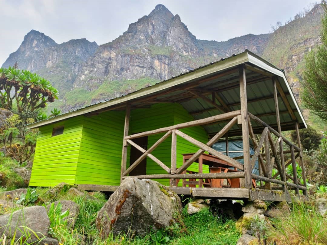
| Accommodation | Sine Camp, Samalira Camp, Mutinda Camp (UWA huts) |
| Price Indicator | From US $645 per person |
| Booking | WhatsApp: +256 773 256 104 |
Why the 4-Day Rwenzori Trek to Mutinda Lookout?
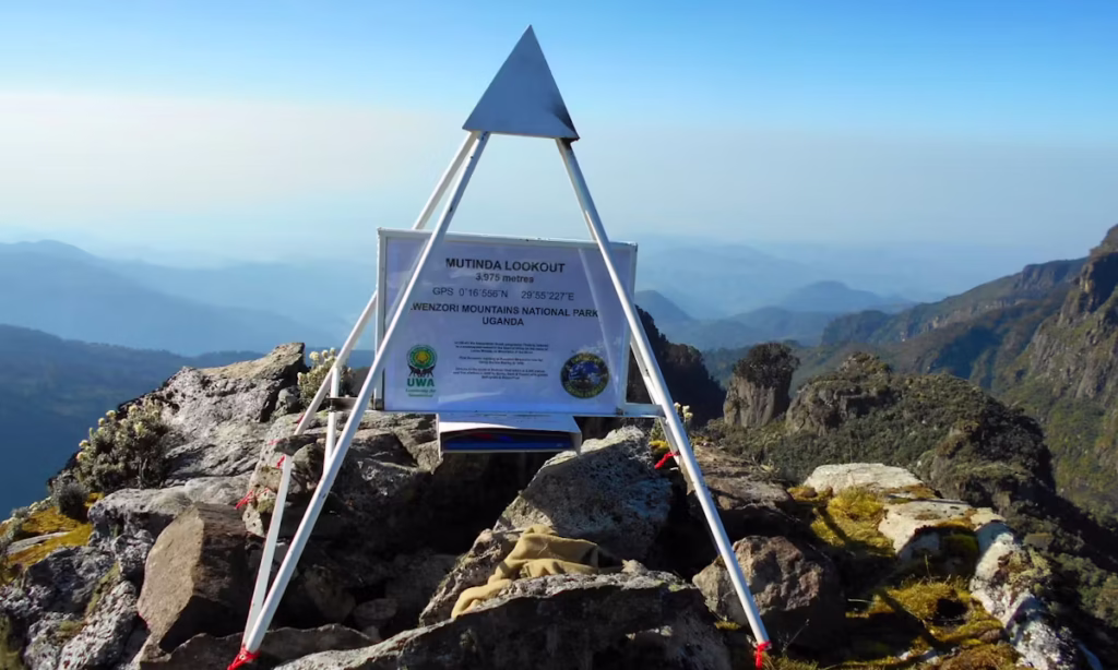
At 3,975 metres, Mutinda Lookout is the highest point reachable on a non-summit Rwenzori trek. It is located in the upper moorland zone of the Kilembe Trail, well above the bamboo and Afro-montane forest belt, where giant lobelias, tree heathers that are two metres tall, and extraordinary high-altitude bogs dominate the landscape. On a clear morning from the Mutinda ridge, the glaciered summits of Mount Stanley and Mount Baker are visible above the cloud line, the same peaks that summit-bound trekkers spend seven or eight days reaching. Here you see them after four. This trek offers a unique proposition: maximum altitude, maximum scenery, and maximum immersion in the Rwenzori’s legendary landscape, all without the technical glacier sections, the altitude above 4,500 metres, or the 7 to 8 day commitment required for a summit expedition.
The Kilembe Trail is the Rwenzori’s southern route, starting from the former copper mining town of Kilembe rather than from Nyakalengija on the north side. This gives it a character distinctly different from the Central Circuit Trail. The Kilembe approach climbs through dense montane and bamboo forest into a series of waterfalls, high river gorges, and finally the open moorland above 3,500 metres. The trail passes through less trafficked terrain than the Central Circuit and has a more exploratory, less established feel that many experienced trekkers actively prefer. For those who have done the Central Circuit and want to experience the Rwenzori from an entirely different angle, the 4-Day Mutinda trek via Kilembe is the natural next choice.
The four camps on this route, Kilembe base, Sine Camp (2,571 m), Samalira Camp (2,860 m), and Mutinda Camp (3,668 m), each represent a distinct stage of the mountain’s ecological progression. By Day 3, you are sleeping in the upper heather moorland and walking to a viewpoint at 3,975 metres that the vast majority of Rwenzori visitors never reach. The giant lobelia colonies above Samalira, the hypericum moorland stretching toward the ridge, and the absolute silence of the upper mountain at this elevation are what make serious Rwenzori trekking special. Our complete comparison of the Central Circuit vs Kilembe Trail helps trekkers decide which route matches their goals.
For those wondering whether to use this 4-day trek as a stepping stone to a full summit expedition, the answer is consistently yes. Mutinda Lookout, at 3,975 metres is a superb acclimatization and fitness test. Trekkers who reach it comfortably are well positioned to attempt the 8-day Margherita Peak climb via the Kilembe Trail or the 7-day Margherita Peak climb via the Central Circuit. Four days to Mutinda is the most honest and thorough way to know whether the summit is for you.
Full Day-by-Day Itinerary: 4-Day Rwenzori Trek to Mutinda Lookout
Kilembe Trail Route OverviewThe 4-Day Mutinda Lookout trek uses the Kilembe Trail, which approaches the Rwenzori from the south via Kilembe town. The ascent follows the Mubuku River valley before branching onto the Kilembe drainage system through Sine Camp, Samalira Camp, and Mutinda Camp to the Mutinda Lookout ridge at 3,975 m. The return route descends via the same trail. Total distance: approximately 44 km over four days. |
Day 1: Kilembe Trailhead to Sine Camp | 1,500 m to 2,571 m | ~9 km | 4 to 5 hours
The 4-day Rwenzori trek to Mutinda Lookout begins at Kilembe, a town defined by its copper mining heritage and its position at the foot of the Rwenzori’s southern slopes. The trailhead sits at approximately 1,500 metres, making it slightly lower than the Central Circuit’s Nyakalengija entry point. After registration at the Uganda Wildlife Authority ranger post and equipment checks, the trail departs northward into the lower montane forest.
The first day’s route climbs 1,071 metres over 9 kilometers, establishing the pattern of the trek: sustained ascent through progressively denser and more dramatic vegetation. From Kilembe, the path crosses the Mubuku River on a bridge and begins climbing through farmland and banana groves, which quickly give way to the lower forest boundary of Rwenzori Mountains National Park. The transition from cultivated land to protected forest is abrupt and immediately noticeable in temperature, humidity, and the density of birdsong overhead.
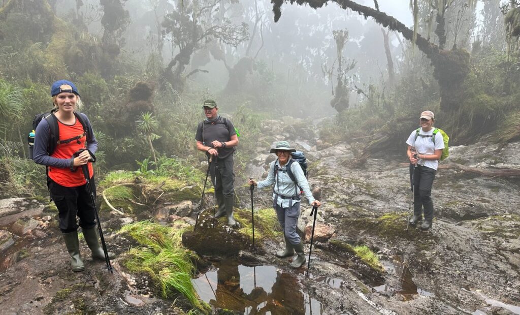
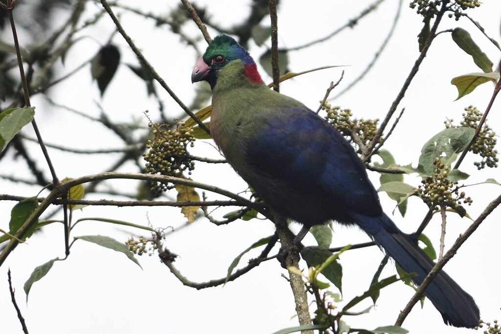
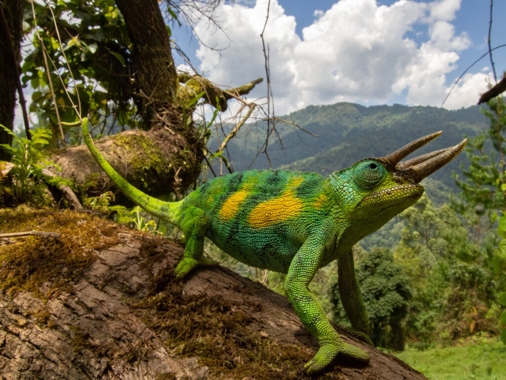
Within an hour of entering the forest, the lower montane zone begins to establish itself. Podocarpus trees and tall tree ferns create a 20-meter canopy draped in moss. The trail follows the left bank of a river tributary, crossing small streams and climbing steadily over rooted and rocky terrain. Three-horned chameleons are regularly seen on the trail surface. Black-and-white colobus monkeys inhabit the high canopy throughout this section and are often heard crashing through the branches above. The Rwenzori turaco calls from the dense middle canopy.
They reach Sine Camp at 2,571 metres in the early afternoon. The camp occupies a forest clearing with river access and views up the valley toward the higher ridgelines. Wooden huts managed by the Uganda Wildlife Authority provide sleeping accommodation. Your camp cook prepares dinner on arrival. Evenings at Sine Camp are quiet and cold. The forest closes in around the clearing, and the temperature drops to 12 to 15 degrees Celsius after dark.
Day 1 HighlightThe transition from Kilembe farmland to the Rwenzori forest is one of the most immediate and dramatic in all of Rwenzori trekking. Within 20 minutes of the park boundary, you are in dense, dripping, moss-hung montane forest. Nothing prepares most trekkers for how complete and immediate the wilderness is. |
Day 2: Sine Camp to Samalira Camp | 2,571 m to 2,860 m | ~8 km | 4 to 5 hours
Day 2 of the 4-Day Mutinda trek via Kilembe is a shorter day in terms of elevation gain but one of the richest for flora and wildlife observation. From Sine Camp the trail continues northward through the mid-altitude forest, passing through the bamboo zone and climbing steadily to Samalira Camp at 2,860 metres. The elevation gain of 289 metres over 8 kilometers is gentler than on Day 1, giving you more time to observe the changing vegetation and wildlife around you.
The bamboo forest section on this portion of the Kilembe Trail is one of the finest on the entire Rwenzori range. Giant bamboo (Arundinaria alpina) stands, which can rise to 15 metres, line both sides of the trail, creating a remarkable enclosed environment. This section is the zone with the highest density of bamboo-specialist birds on the Kilembe side of the mountain: the African emerald cuckoo, Rwenzori double-collared sunbird, and mountain illadopsis are all present. Our Rwenzori wildlife guide provides the full species catalog with identification notes.
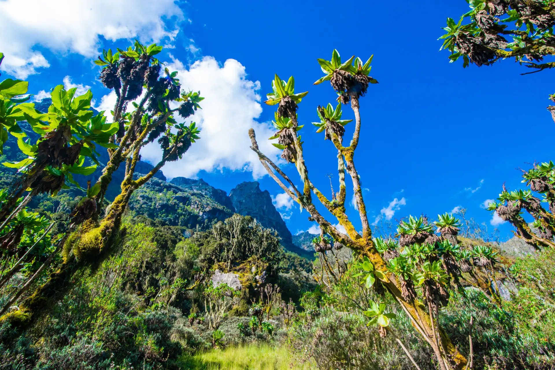
Above the bamboo zone, the trail leads into upper Afro-montane forest, where the main trees are Hagenia abyssinica and Hypericum. These are the first of the Rwenzori’s high-altitude tree species and signal that you are approaching the threshold between forest and moorland. The first giant lobelias begin to appear above 2,700 metres: alien-looking rosette plants that can grow to 4 metres in height, their flower spikes rising above a base of enormous waxy leaves. These are the Rwenzori’s most iconic plant species, and seeing the first one is a genuinely memorable moment on any Kilembe Trail trek.
Samalira Camp sits at 2,860 metres in a transition zone between the upper forest and the start of the open heather moorland. The camp has wooden huts, pit latrines, and stream water. The views from the camp clearing extend down the valley toward Kilembe and across to the ridgelines on the western side of the drainage. On clear evenings the sky is extraordinary at this altitude.
Day 2 HighlightThe first giant lobelia sighting. Above 2,700 metres on the Kilembe Trail, giant lobelias (Lobelia wollastonii) begin to appear beside the path. These are not small plants: they grow to 4 metres and more, with enormous geometric rosettes. Seeing one for the first time stops every trekker in their tracks. |
Day 3: Samalira Camp to Mutinda Lookout & Return to Mutinda Camp | 2,860 m to 3,975 m | ~14 km | 6 to 8 hours
Day 3 is the climax of the 4-Day Rwenzori trek to Mutinda Lookout. From Samalira Camp the trail climbs northward and upward through the upper forest and into the open moorland, reaching Mutinda Camp at 3,668 metres before the final push to the Mutinda Lookout ridge at 3,975 metres. This is the longest and most demanding day of the four, combining a significant elevation gain of 1,115 metres with the altitude effects that begin to be felt above 3,500 metres.
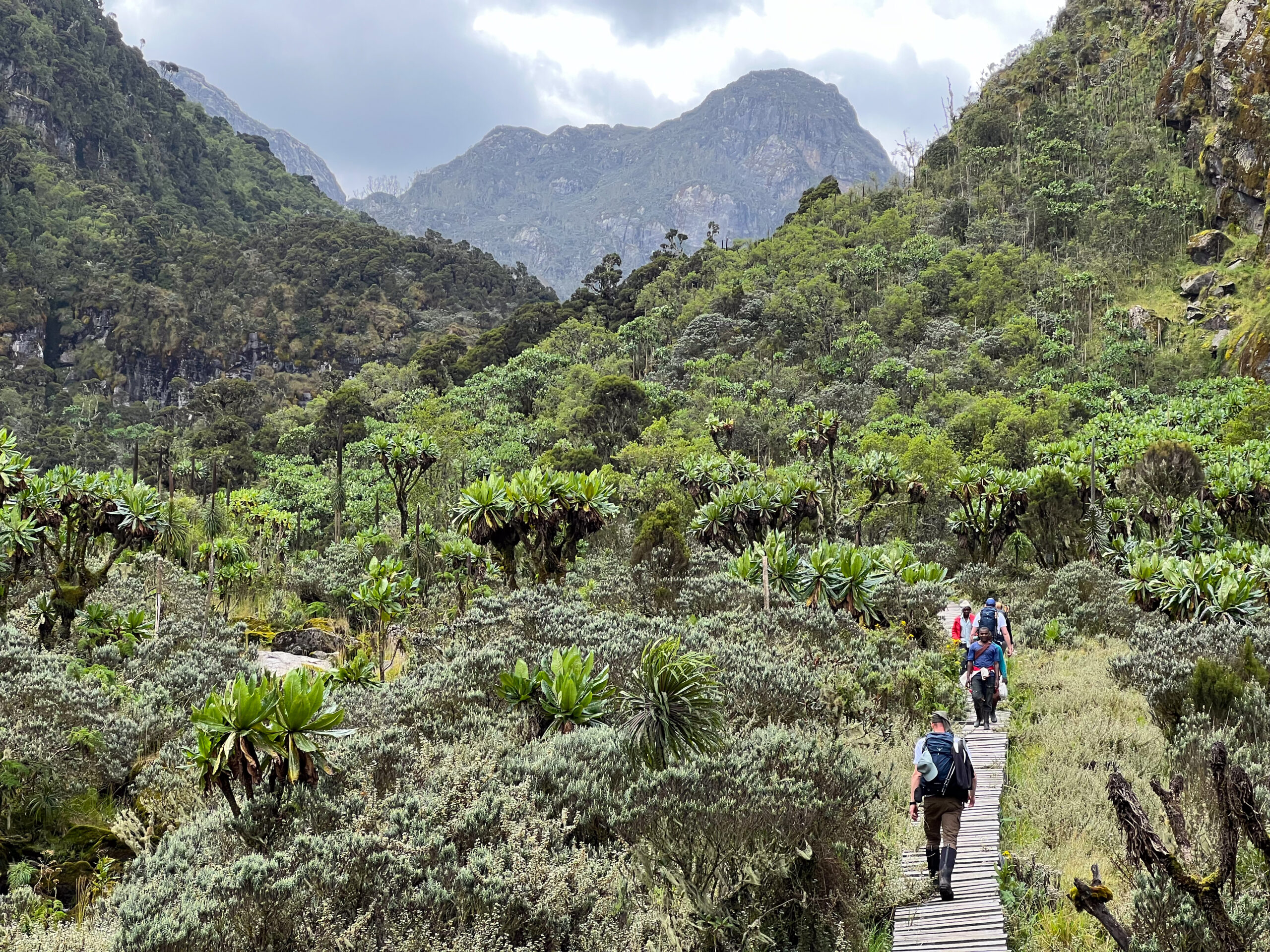
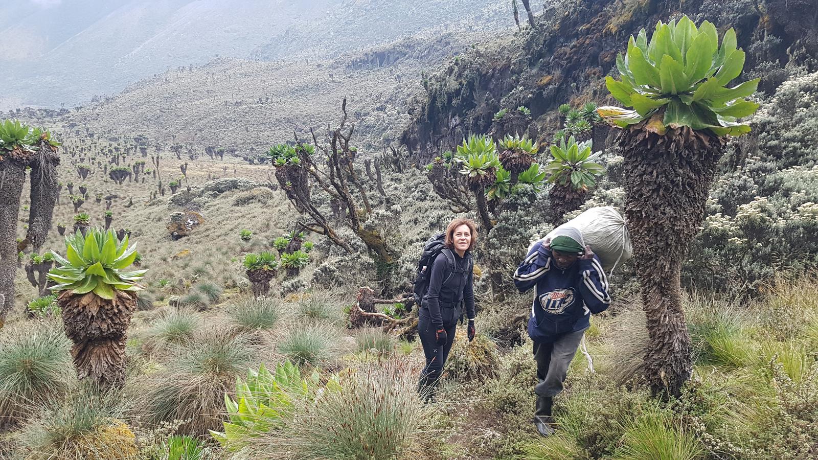
Departure from Samalira Camp at first light (06:30) gives the best chance of clear conditions at Mutinda Lookout before the afternoon cloud builds. The trail above Samalira enters the full moorland zone within 30 minutes of leaving camp. The forest cover breaks and the landscape opens dramatically. Giant lobelias in increasing density line both sides of the path. Giant groundsels (Dendrosenecio adnivalis), the tree-sized cousins of the garden groundsel, begin to appear at around 3,200 metres, their stout trunks topped with rosettes of silver-green leaves. This area is the iconic Rwenzori giant plant landscape that appears in almost every published photograph of the range.

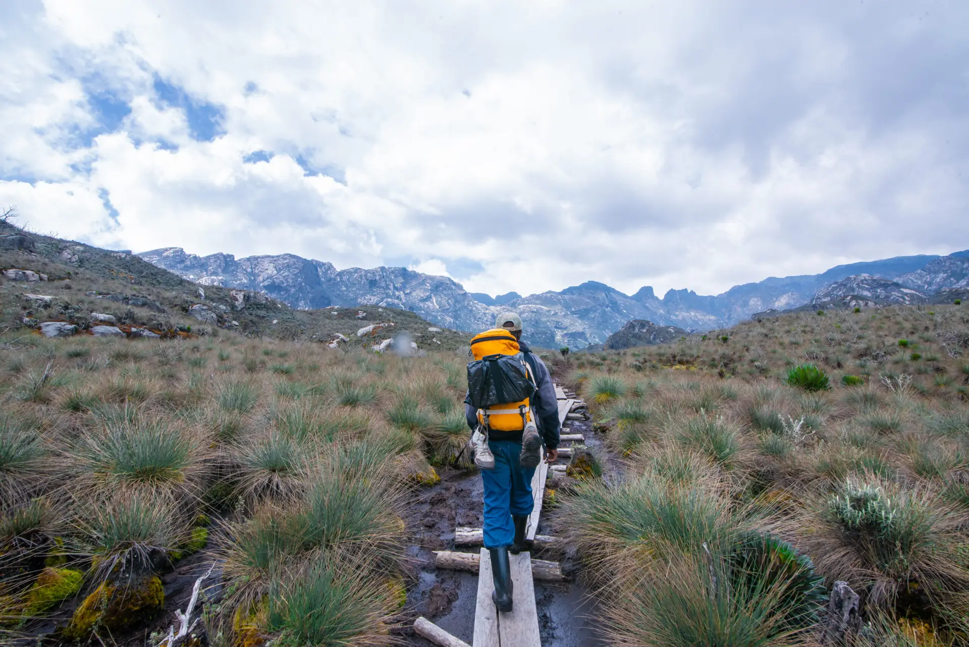
The path climbs through moorland and high-altitude bog between 3,000 and 3,500 metres. This is classic Rwenzori terrain: waterlogged peat, tussock grasses, and sphagnum moss creating a spongy, uneven surface that requires careful foot placement. Rubber boots are essential here regardless of season. The Rwenzori boot and footwear guide explains exactly why rubber boots are non-negotiable in the upper mountain zones.
After approximately 4 hours from Samalira, you will reach Mutinda Camp, which is at 3,668 metres. This is a high, exposed camp in the open moorland with panoramic views and significantly lower temperatures than the lower camps. After a short rest and lunch at Mutinda Camp, the trail pushes 307 metres higher to the Mutinda Lookout ridge at 3,975 metres. This final section climbs steeply through heather moorland and open rocky terrain, and at the top the view is one of the finest available anywhere on the Rwenzori without glacier travel.
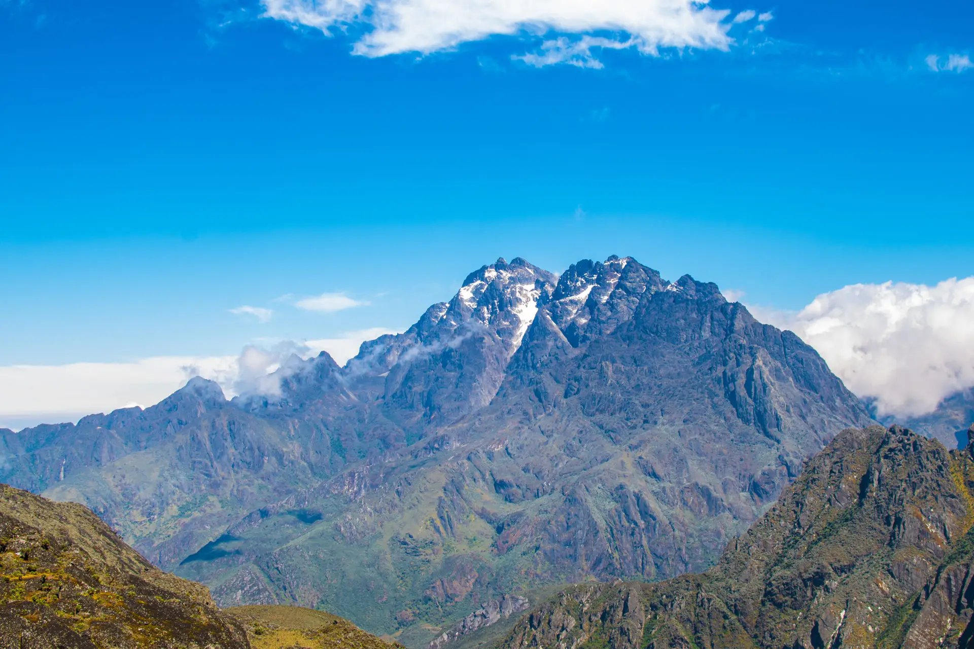
From Mutinda Lookout at 3,975 metres, the upper Rwenzori fully reveals itself. On clear days most common in December through February and June through August, the glaciered summits of Mount Stanley (5,109 m), including Margherita Peak, and Mount Baker (4,843 m) are visible above the cloud layer. The entire upper Bujuku Valley and the ridge systems that define the Central Circuit are visible from this viewpoint. For trekkers who want to understand the geography of the full range before committing to a summit expedition, this is the most informative vantage point the mountain offers at non-summit altitude.
After time at the lookout, the trail returns to Mutinda Camp for the third night. The camp, at 3,668 metres, is the highest sleeping point on this itinerary. Temperatures drop to between 2 and 5 degrees Celsius after dark. A sleeping bag rated to -5 degrees Celsius is essential. Dinner is prepared by the camp cook. The night sky at Mutinda Camp, if weather permits, is extraordinary at this altitude and latitude.
Day 3 HighlightStanding at Mutinda Lookout (3,975 m) on a clear morning with the glaciered summits of Margherita Peak (5,109 m) and Mount Baker (4,843 m) visible above the clouds. This is the highest non-technical viewpoint on the Rwenzori, reached without crampons or glacier gear, and it rivals any mountain panorama in East Africa. |
Day 4: Mutinda Camp to Kilembe Trailhead | 3,668 m to 1,500 m | ~13 km | 5 to 6 hours
The final day of the 4-day Rwenzori trek to Mutinda Lookout is a long, sustained descent covering 2,168 metres of elevation loss over approximately 13 kilometers. You leave Mutinda Camp after breakfast and retrace the route through the moorland, past Samalira Camp, through the bamboo forest and lower montane zones, and back to the Kilembe trailhead. The descent takes 5 to 6 hours depending on pace.
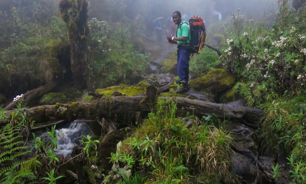
After three days climbing, the descent reveals the mountain in reverse and from different light angles. The giant lobelias and groundsels above Samalira look different on the way down, and the bamboo forest below Samalira takes on new detail when you are moving through it without the urgency of upward momentum. Many trekkers consider the descent the most meditative section of the trek, particularly the forested lower slopes where the sound of the rivers below accompanies the walk back to the valley.
The final section, from the park boundary back through the Kilembe farmland, marks the re-entry to the world below. You arrive at the Kilembe trailhead typically in the early to mid-afternoon. A transfer back to your Kasese accommodation follows, giving the rest of the day and evening for rest, recovery, and reflection. For trekkers considering next steps on the mountain, this is an excellent moment to speak with your guide about the 8-Day Kilembe Trail summit expedition or the 4-Day Rwenzori Waterfalls Hike as a complementary short trail experience on the Kilembe side.
Elevation Profile Summary: 4-Day Kilembe Trail to Mutinda Lookout
The elevation arc of the 4-Day Rwenzori trek to Mutinda Lookout follows a progressive ascent across three days and a single long descent on the fourth. Day 1 climbs from Kilembe at 1,500 metres to Sine Camp at 2,571 metres, a gain of 1,071 metres over 9 kilometers. Day 2 adds a gentler 289 metres from Sine Camp (2,571 m) to Samalira Camp (2,860 m) over 8 kilometers. Day 3 is the most dramatic in terms of elevation, ascending 1,115 metres from Samalira (2,860 m) through Mutinda Camp (3,668 m) to the Mutinda Lookout ridge (3,975 m) before returning to sleep at Mutinda Camp. Day 4 is an uninterrupted descent of 2,168 metres from Mutinda Camp (3,668 m) back to the Kilembe trailhead (1,500 m) over 13 kilometers.
The total elevation gain across the ascent days is 2,475 metres, spread over three consecutive climbing days. This is a significant cumulative gain and one of the primary reasons for rating this trek as challenging rather than moderate. The altitude of 3,975 metres at the lookout is high enough that some trekkers may experience mild altitude symptoms, particularly on the Day 3 push. Good pace management, consistent hydration, and not rushing the ascent above 3,500 metres are the primary defenses.
Camps and Accommodation: 4-Day Mutinda Lookout Trek
Sine Camp | 2,571 m | Night 1
Camp ProfileElevation: 2,571 m | Location: Lower montane forest, left bank of a river tributary | Type: UWA wooden huts | Facilities: Sleeping platforms, pit latrines, stream water (treat before use) | Views: Forest clearing with valley views |
Sine Camp is the first overnight stop on the Kilembe Trail and the point where most trekkers fully adjust to life on the mountain. Situated at 2,571 metres in a forest clearing, the camp has wooden sleeping huts managed by the Uganda Wildlife Authority with foam mattress platforms. The surrounding forest is dense and active with birdlife in the early morning. Temperatures drop to between 10 and 14 degrees Celsius overnight.
Samalira Camp | 2,860 m | Night 2
Camp ProfileElevation: 2,860 m | Location: Upper forest / moorland transition zone | Type: UWA wooden huts | Facilities: Sleeping platforms, pit latrines, stream water | Views: Valley views toward Kilembe; open sky above the forest |
Samalira Camp, at 2,860 metres, marks the transition between the dense Afro-montane forest below and the open moorland above. The camp feels distinctly different from Sine Camp: the canopy is more open, the air noticeably colder, and the first glimpses of the upper Rwenzori landscape are visible above the treeline. Giant lobelias are present in the immediate camp vicinity. Overnight temperatures drop to between 7 and 10 degrees Celsius.
Mutinda Camp | 3,668 m | Night 3
Camp ProfileElevation: 3,668 m | Location: Open moorland, upper Kilembe Trail | Type: UWA wooden huts | Facilities: Sleeping platforms, pit latrines, stream water | Views: Panoramic moorland views; upper peaks visible on clear days |
Mutinda Camp, at 3,668 metres is the highest sleeping point on this itinerary and one of the most dramatically positioned camps on the entire Kilembe Trail. The camp sits in open heather moorland with giant lobelias and groundsels visible in every direction. The Mutinda Lookout ridge rises directly above camp, and on clear mornings, the glaciered upper peaks come into view from the hut doorway. Overnight, temperatures drop to between 2 and 5 degrees Celsius. A sleeping bag rated to at least -5 degrees Celsius is essential.
For the full infrastructure and facilities description across all Rwenzori camps on both trails, see our comprehensive guide to Rwenzori Mountain huts and campsites.
Flora and Wildlife on the 4-Day Mutinda Lookout Trek
The 4-Day Rwenzori trek to Mutinda Lookout passes through more vegetation zones than any other short-format trek in the Rwenzori range. From Kilembe at 1,500 metres to the Mutinda Lookout ridge at 3,975 metres, you traverse five distinct plant communities, each with its own characteristic wildlife. Our Rwenzori wildlife guide and vegetation zones guide cover every species in detail. The zones crossed on this itinerary are:
1. Lower Montane Forest (1,500 m to 2,200 m)
Dominated by tall Podocarpus and Ficalhoa trees, giant tree ferns, and prolific epiphytes. Dense, warm, and humid. Primary habitat for black-and-white colobus monkeys, blue monkeys, Rwenzori turacos, and three-horned chameleons. Wildlife density is highest in this zone.
2. Mountain Bamboo Zone (2,200 m to 2,600 m)
Giant bamboo (Arundinaria alpina) can grow to a height of 15 metres. Cathedral-like trail environment. Home to the African emerald cuckoo, Rwenzori double-collared sunbird, and mountain illadopsis. This zone crosses the full Day 2 ascent between Sine and Samalira Camps.
3. Upper Afro-Montane Forest (2,600 m to 3,100 m)
Hagenia abyssinica and Hypericum trees in a mossy, lichen-saturated environment. Giant lobelias (Lobelia wollastonii) begin to appear above 2,700 metres. The first tree heathers (Erica arborea) appear here. The forest floor is rich in ferns, sedges, and mosses.
4. High-Altitude Moorland (3,100 m to 3,700 m)
Open heather and Hypericum moorland with saturated peat bogs and tussock grasses. Giant groundsels (Dendrosenecio adnivalis) become dominant alongside giant lobelias (Lobelia wollastonii), growing to 4 metres. This is the zone’s most iconic and photographed landscape. Hyraxes are common and often seen on the rocky outcrops.
5. Alpine Zone (3,700 m to 3,975 m)
Above Mutinda Camp the vegetation shifts to low heathers, everlastings (Helichrysum), sedges, and rocky outcrops with sparse colonization. The air is thin and clear on fair days. Ravens and alpine swifts are common at this elevation. On rare occasions olive baboons from the lower forest ascend to the moorland fringes.
Key Wildlife Species on the 4-Day Mutinda Trek
- Black-and-white colobus monkey (Colobus guereza): abundant in the lower and mid-altitude forest sections.
- Blue monkey (Cercopithecus mitis): present throughout the lower forest zones.
- The Rwenzori turaco (Ruwenzorornis johnstoni) is endemic to the Rwenzori, and its red wing flashes are unmistakable when it flies.
- African emerald cuckoo (Chrysococcyx cupreus): metallic green; bamboo zone specialist; most visible on Day 2.
- Three-horned chameleon (Trioceros johnstoni): Rwenzori endemic; frequently seen on the trail in lower forest zones.
- Giant lobelia (Lobelia wollastonii): the plant symbol of the Rwenzori; spectacular specimens appear from 2,700 m upward.
- Giant groundsel (Dendrosenecio adnivalis): 3 to 6 metre tree-sized groundsels in the moorland above 3,200 m.
- Tree hyrax (Dendrohyrax arboreus): heard from the mid-altitude forest and moorland edges, particularly at dawn.
- Mountain buzzard (Buteo oreophilus): regularly soaring above valley ridges on descent days.
- White-naped raven (Corvus albicollis): frequent at Mutinda Camp and the upper moorland.
Physical Difficulty and Fitness Requirements
The 4-Day Rwenzori trek to Mutinda Lookout is honestly rated as challenging. Three days of climbing on wet, rooted, and steep terrain, with a total elevation gain of 2,475 metres, plus the altitude of 3,975 metres at the lookout and 3,668 metres for the third overnight camp, makes this trek genuinely demanding. It is accessible to fit and well-prepared trekkers without technical mountain experience, but it is not a casual walking holiday. Our full Rwenzori fitness and training guide provides detailed preparation protocols for all trek lengths.
Unlike the short 1- or 2-day treks that stay below 3,000 metres, the Mutinda Lookout trek takes you into altitude territory where acclimatization matters. Above 3,500 metres some trekkers experience headaches, reduced appetite, and mild breathlessness. These symptoms are common at altitude and usually manageable with a measured pace, consistent hydration, and a good night’s sleep at Mutinda Camp before the lookout push. Serious altitude illness is uncommon at 3,975 metres in otherwise healthy adults, but see our complete medical guide to Rwenzori trekking and altitude acclimatization for full details on recognizing and managing altitude effects.
Recommended Fitness Preparation
- A minimum of 8 to 10 weeks of specific cardiovascular training before the trek
- Multiple multi-day hiking trips with overnight camping in the months before departure
- Ability to hike continuously uphill for 4 to 5 hours with a 12 to 15 kg pack
- Prior experience on wet, rooted, and uneven mountain terrain is strongly beneficial
- Comfort with cold nights (temperatures to 2 degrees Celsius at Mutinda Camp)
Who This Trek Suits Best
- Experienced hikers seeking a serious multi-day mountain challenge without technical sections
- Trekkers considering a Rwenzori summit who want to acclimatise and assess themselves first
- Older trekkers who are fit, regularly active, and want the deepest possible Rwenzori experience without glacier travel
- Naturalists, birdwatchers, and botanists for whom the full elevation transect of vegetation zones is the primary objective
- Trekkers who have completed the Rwenzori’s shorter treks and want a significantly more demanding next challenge
Who Should Consider an Alternative
- First-time mountain trekkers with limited fitness preparation (consider the 2-Day Lake Mahoma Hike or 3-Day Mahoma Loop first)
- Trekkers with serious cardiovascular, respiratory, or joint conditions
- Those who are not comfortable sleeping in cold conditions at 3,668 metres
Best Time for the 4-Day Rwenzori Trek to Mutinda Lookout
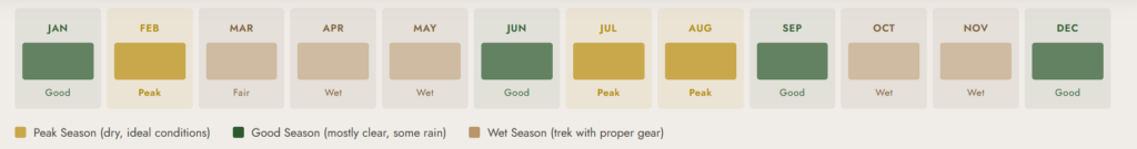
The Kilembe Trail is trekable year-round. For a full seasonal analysis, see our best time to visit the Rwenzori Mountains. For the 4-day Mutinda trek specifically, the season has a pronounced effect because the clarity of the Day 3 summit views from the lookout depends significantly on weather conditions:
| Season / Month | Conditions & Notes |
| December to February (Dry) | Best overall conditions. Firmest trails, clearest views from Mutinda Lookout, and most stable weather for the third night at high camp. Peak season. Optimal photography window. |
| June to August (Dry) | Excellent. Slightly warmer than Dec-Feb; excellent visibility. Giant lobelias and groundsels are green and active. Ideal for botanical and wildlife photography. |
| March to May (Wet Season) | Possible with full waterproofs and rubber boots. Heavy rain and a very muddy trail, particularly in the moorland. Clouds frequently obscure lookout views. Extraordinary forest atmosphere. Fewer trekkers means true solitude. |
| September to November (Wet Season) | Similar to March-May. Frequent rain and mist above 3,000 m. Views from Mutinda are often limited. The moorland landscape is at its most atmospheric but least visually rewarding for panoramic views. Full waterproofs are mandatory. |
The Day 3 panoramic view from Mutinda Lookout is the centerpiece of this trek. Clear visibility requires dry season conditions. If you are traveling primarily for the summit views, December to February or June to August offers the best chance of a clear morning at 3,975 metres. The Rwenzori’s wet season brings heavier rain but genuinely extraordinary forest conditions that experienced trekkers who have already seen the dry-season views often prefer.
What’s Included and What’s Not Included
| INCLUDED IN THE PACKAGE | NOT INCLUDED |
| Uganda Wildlife Authority park entry fees (all 4 days) | International flights and transfers to Uganda |
| UWA ranger guide (mandatory; certified) | Travel insurance (strongly recommended) |
| Rwenzori Trekking Safaris lead guide | Personal trekking gear and clothing |
| All park permits and documentation | Personal medications and first aid supplies |
| Porter service for camp equipment and food (3 nights) | Gratuities for guides and porters |
| All meals: Day 1 dinner through Day 4 lunch | Alcoholic beverages and personal snacks |
| Overnight accommodation at Sine, Samalira & Mutinda Camps | Pre/post-trek hotel in Kasese |
| Return road transfer: Kasese to Kilembe trailhead | Optional rubber boot hire at trailhead (~$5) |
| Cooking equipment, camp kitchen supplies | Personal sleeping bag and insulation layers |
Rwenzori Travel InsuranceTravel insurance covering emergency medical evacuation and high-altitude trekking is essential for the 4-Day Mutinda trek. At 3,975 metres, you are in territory where altitude illness is possible, and any injury or medical event requires professional rescue coordination from remote terrain. See our dedicated travel insurance guide for exactly what cover you need. |
Full Packing and Gear List: 4-Day Mutinda Lookout Trek
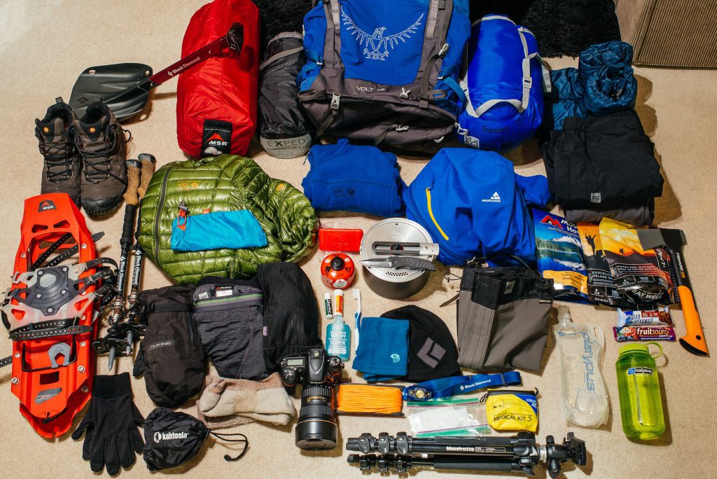
The gear requirements for the 4-Day Mutinda Lookout trek are more demanding than for shorter lower-altitude Rwenzori treks. At 3,975 metres with three consecutive nights in the mountains, warm sleeping gear, complete waterproofs, and the right footwear are not optional. Our master Rwenzori packing list covers all trek lengths in full detail.
Footwear
- Rubber boots with ankle support and deep lug soles: essential for moorland bog sections above 3,000 m and wet forests throughout (hireable at trailhead)
- Three pairs of wool or synthetic socks (a clean dry pair for each day)
- Lightweight camp shoes or sandals for evenings at camp
Clothing
- Moisture-wicking base layer top and bottom (synthetic or merino wool; never cotton)
- Warm mid-layer: heavyweight fleece or light down jacket (essential at Mutinda Camp 2-5 C)
- Down jacket or heavyweight insulation layer for evenings and nights at Mutinda Camp
- Quality waterproof hardshell jacket with hood (GORE-TEX or equivalent)
- Waterproof trousers or hardshell pants (for the boggy moorland sections above 3,000 m)
- Warm insulated gloves: essential at 3,975 m; waterproof outer layer recommended
- Warm hat covering ears (temperatures to 2 C at Mutinda Camp)
- Sun hat and sunglasses (UV exposure increases significantly above 3,500 m)
- Quick-dry hiking trousers (two pairs for a 4-day trek)
Sleeping
- Sleeping bag rated to -5 degrees Celsius minimum (0 degrees is insufficient at Mutinda Camp)
- Sleeping bag liner for added warmth and camp hygiene
- Headlamp with spare batteries (4 nights in the dark; essential)
- Earplugs (hyraxes and wind are persistent at high camp)
Equipment
- Two trekking poles (essential on all four days: ascending and descending steep wet terrain)
- Trekking pack 40 to 50 litres (for items not carried by porter)
- Dry bags or waterproof stuff sacks for sleeping bag, electronics, and spare clothing
- Water bottle or hydration reservoir (2 litres minimum at all times)
- Water purification tablets or portable filter
- Trekking gaiters (useful for bog sections in the moorland above 3,000 m)
Health and Nutrition
- Personal first aid kit including blister treatment, pain relief, and altitude medication (consult your doctor about acetazolamide/Diamox before departure)
- Energy bars, trail mix, chocolate, and high-energy personal snacks for all four days
- Electrolyte sachets (strongly recommended for the Day 3 climb to 3,975 m)
- Sunscreen SPF 50+ (UV intensity is high at altitude even in cloud cover)
- Lip balm with sun protection
- Insect repellent (lower forest sections of Days 1 and 2)
- Any personal prescription medications in sufficient quantity
Photography and Electronics
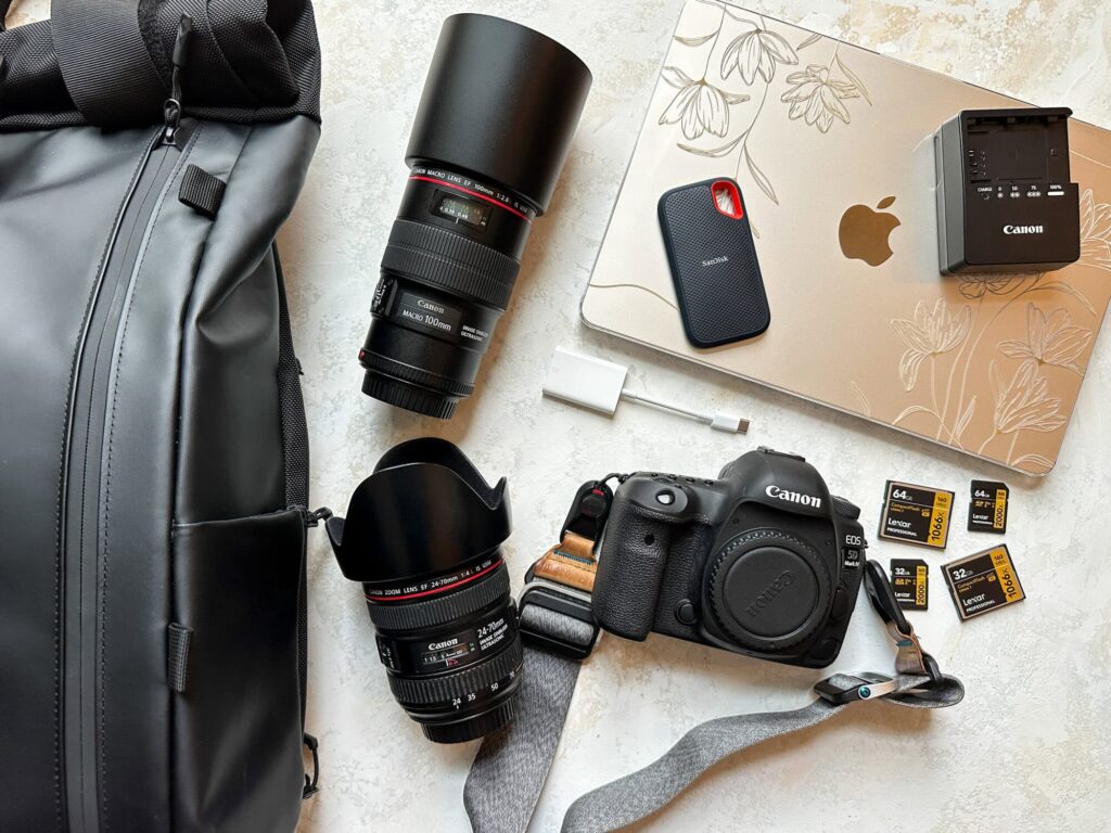
- Camera with weather sealing or in a waterproof dry bag (the moorland is wet year-round)
- Spare batteries and memory cards (no charging for 4 nights)
- Portable power bank for phone and camera charging
- Binoculars (strongly recommended for the exceptional birdwatching on Days 1 and 2)
Permits, Park Fees and Costs
All trekking in Rwenzori Mountains National Park requires Uganda Wildlife Authority permits and registration. For a complete breakdown of all costs across all trek lengths, see our complete guide to the cost of climbing the Rwenzori Mountains.
| Cost Component | Amount (USD, approximate) |
| UWA Park Entry Fee | $40 per person per day x 4 = $160 per person |
| UWA Ranger Guide Fee | Included in RTS package |
| Rwenzori Trekking Safaris Lead Guide | Included in RTS package |
| Porter Fee (per porter, per day) | $15 to $20 per porter (1 porter strongly recommended) |
| Camp Fees (Sine, Samalira, Mutinda) | Included in RTS package |
| All Meals (Day 1 dinner to Day 4 lunch) | Included in RTS package |
| Total RTS Package | From US $645 per person |
| Optional Rubber Boot Hire | $5 at Kilembe trailhead |
Porter support for the 4-Day Mutinda Lookout trek is strongly recommended. Carrying full overnight gear for four days at altitudes of up to 3,975 metres significantly increases the physical demands. Your porter carries the camp equipment and heavier items, allowing you to focus on the hiking and wildlife experience. Our guide to Rwenzori porters and fair tipping explains fair wage standards and the cultural importance of the porter system to Bakonzo mountain communities.
Getting to the Kilembe Trailhead: Logistics and Transport
The 4-day Rwenzori trek to Mutinda Lookout starts from Kilembe, approximately 12 km east of Kasese town. Our full guide to getting to the Rwenzori Mountains covers all transport options from Kampala and Entebbe. Practical summary:
From Kampala to Kasese
Kampala to Kasese is approximately 415 km via the Mbarara highway: 5.5 to 6.5 hours by private vehicle. Coach services from Kisenyi Bus Terminal (Horizon Bus, Link Bus) take 6 to 7 hours. For trekkers arriving from Kampala, we recommend an overnight stop in Kasese before the trek starts. Our Kasese town guide covers hotels, restaurants, and pre-trek logistics.
From Entebbe Airport to Kasese
Entebbe to Kasese is approximately 370 km: 5 hours by private vehicle. Private transfers from Entebbe Airport can be arranged through Rwenzori Trekking Safaris on request. An overnight stop in Kasese before the trek is strongly recommended.
From Kasese to Kilembe Trailhead
Kilembe is 12 km east of Kasese town on the road toward the mountains: approximately 20 minutes by vehicle. All Rwenzori Trekking Safaris packages include a return road transfer between Kasese and the Kilembe trailhead. For accommodation in Kasese before and after the trek, you can check our pre- and post-trek accommodation guide.
Book Your Trek
Respond within Minutes
From
$645
per person
- Duration 4 Days / 3 Nights
- Group Size 1–12 people
- Start Point Kilembe TrailHead
- Departures Year-round
- Summits Mutinda Lookout
No booking fee. Free cancellation up to 30 days before departure. We respond within Minutes.
Our Popular Rwenzori Treks
Magheritah Peak (8 Days Kilembe Trail)
$1705 Per Person
Mutinda LookOut (4 Days)
$645 Per Person
Short Magherita Hike (5 Days Central Circuit)
$1200 Per Person
Rwenzori Hike (7 Days Central Circuit)
$1400 Per Person
Frequently Asked Questions: 4-Day Rwenzori Trek to Mutinda Lookout
How difficult is the 4-Day Rwenzori trek to Mutinda Lookout?
The 4-Day Rwenzori trek to Mutinda Lookout is rated as challenging. Three days of climbing, with a total elevation gain of 2,475 metres, plus the wet and rooted Rwenzori terrain and the altitude of 3,975 metres at the lookout, makes this trek much harder than moderate difficulty. The key physical demands are sustained uphill effort over multiple days, good fitness for carrying a daypack on steep and slippery terrain, and the ability to cope with cold nights at 3,668 metres at Mutinda Camp. Trekkers who are regularly active, have completed multi-day hill walks, and have trained specifically for 8 to 10 weeks before departure consistently rate this trek as hard but thoroughly achievable.
What is Mutinda Lookout and how high is it?
Mutinda Lookout is a viewpoint at 3,975 metres on the upper Kilembe Trail in Rwenzori Mountains National Park, Uganda. It sits on a ridge in the open heather moorland above Mutinda Camp (3,668 m), well within the alpine zone of the range. On clear days the lookout offers unobstructed views of the glaciated summits of Mount Stanley (5,109 m), including Margherita Peak, and Mount Baker (4,843 m). It is the highest nontechnical viewpoint on the Rwenzori range accessible without crampons, glacier gear, or rope, and it is reached via the Kilembe Trail in four days from Kasese.
Is the 4-Day Mutinda Lookout trek suitable for beginners?
The 4-Day Rwenzori trek to Mutinda Lookout is not recommended as a first mountain trekking experience. The combination of four consecutive days on demanding terrain, high altitude at Mutinda Camp (3,668 m), and the accumulated physical effort of 2,475 metres of elevation gain makes this trek more suitable for those with prior mountain hiking experience. Fit beginners who are specifically passionate about the Rwenzori Mountains and have undertaken a rigorous 8- to 10-week training program may be able to complete this trek, but we strongly recommend starting with the 2-Day Lake Mahoma Hike or the 3-Day Mahoma Loop as a foundation before attempting Mutinda.
What is the best time of year to do the 4-Day Mutinda Lookout trek?
The best time for the 4-Day Rwenzori trek to Mutinda Lookout is during Uganda’s two dry seasons: December through February and June through August. In these months the trail conditions are firmest, the probability of clear views from Mutinda Lookout at 3,975 metres is highest, and overnight conditions at Mutinda Camp are most comfortable. The wet seasons (March to May and September to November) bring heavier rain, muddier trails, and more frequent cloud cover at the lookout, but the trek remains possible, and the lower forest sections are exceptionally lush and atmospheric.
How cold does it get at Mutinda Camp (3,668 m)?
Temperatures at Mutinda Camp (3,668 m) drop to between 2 and 5 degrees Celsius on dry season nights and can reach 0 degrees Celsius or below on wet season nights with heavy cloud cover. This is significantly colder than the lower camps at Sine (2,571 m) and Samalira (2,860 m), where overnight temperatures stay between 6 and 14 degrees Celsius. A sleeping bag rated to -5 degrees Celsius is the minimum recommendation for Mutinda Camp, along with a thermal liner, warm base layers, and a heavyweight mid-layer fleece or insulated jacket worn in the sleeping bag if temperatures drop unexpectedly.
Do I need special equipment for the 4-Day Mutinda Lookout trek?
The 4-Day Rwenzori trek to Mutinda Lookout does not require technical equipment such as crampons, ice axes, or rope. It is a non-technical trek despite reaching 3,975 metres. However, several items are essential rather than optional: rubber boots with ankle support for the boggy moorland sections above 3,000 metres, a full waterproof hardshell jacket and trousers, a sleeping bag rated to -5 degrees Celsius for Mutinda Camp, two trekking poles for the steep and rooted terrain on all four days, and warm insulated gloves for the Day 3 summit push. None of these items are technically specialised, but all are genuinely necessary rather than merely recommended.
What wildlife and plants will I see on the 4-Day Mutinda Lookout trek?
The 4-day Rwenzori trek to Mutinda Lookout passes through five distinct vegetation zones from 1,500 to 3,975 metres, making it the most botanically diverse of any short Rwenzori itinerary. Wildlife highlights include black-and-white colobus monkeys in the lower forest; Rwenzori turacos and three-horned chameleons throughout the forest zones; African emerald cuckoos in the bamboo section on Day 2; and the famous giant lobelias (Lobelia wollastonii) and giant groundsels (Dendrosenecio adnivalis) above 3,000 metres. Hyraxes are common in the upper moorland and are frequently heard and seen around Mutinda Camp. The lookout ridge itself is frequented by white-naped ravens and alpine swifts.
Can I extend the 4-Day Mutinda Lookout trek into a full summit expedition?
Yes, and it is a natural progression. The 4-Day Mutinda Lookout trek uses the same Kilembe Trail that the summit expeditions follow. After reaching Mutinda Lookout, the route to Margherita Peak continues northward through the upper Kilembe Trail toward Weismann Pass, and the summit approaches on Mount Stanley. The most direct extension is the 8-Day Margherita Peak Climb via the Kilembe Trail, which follows the same route through Mutinda and continues above. If you complete the 4-Day Mutinda trek and feel strong at altitude, you are very well positioned to attempt the summit on a future expedition.
What is the difference between the Kilembe Trail and the Central Circuit Trail?
The Kilembe Trail and Central Circuit Trail are the two main routes through the Rwenzori Mountains. The Kilembe Trail starts from Kilembe on the south side of the range and follows the Mubuku River valley northward through Sine, Samalira, and Mutinda Camps before connecting to the upper mountain. The Central Circuit Trail starts from Nyakalengija on the north side and loops around the main massif through Nyabitaba, Nyamuleju, Bigo, and Bujuku camps. The Kilembe Trail is generally considered less trafficked, more exploratory in character, and particularly noted for its waterfalls, bamboo forest, and giant plant moorland. Our detailed Central Circuit vs Kilembe Trail comparison covers every difference between the two routes honestly.
Is altitude sickness a risk on the 4-Day Mutinda Lookout trek?
Altitude sickness is a genuine concern on the 4-Day Rwenzori trek to Mutinda Lookout. At 3,975 metres at the lookout and 3,668 metres at Mutinda Camp, you are in the altitude range where acute mountain sickness (AMS) symptoms such as headache, nausea, reduced appetite, and fatigue are commonly experienced. Serious altitude illness (HACE or HAPE) is uncommon at these altitudes in otherwise healthy adults, but we cannot completely rule it out. The best preventions are a measured pace on Day 3’s ascent, consistent hydration throughout all four days, not ascending with existing headache or nausea, and descending immediately if symptoms worsen. Some trekkers discuss acetazolamide (Diamox) with their doctor before departure. Our altitude acclimatization guide and complete medical guide provide full guidance.
How do I book the 4-Day Rwenzori trek to Mutinda Lookout via Kilembe Trail?
The 4-Day Rwenzori trek to Mutinda Lookout can be booked directly through Rwenzori Trekking Safaris. Contact us via WhatsApp at +256 773 256 104 for an immediate response, by email at rwenzoritrekkingsafaris@gmail.com, or through the contact form.
Our team will confirm available dates, answer specific questions about fitness and gear preparation, and handle all park permits, porter arrangements, and camp bookings. We recommend booking at least 3 to 4 weeks in advance for peak season dates in December through February and June through August.
Ready to Reach Mutinda Lookout? Book Your 4-Day Trek Today
From US $645 per person | Fully Guided | All Meals & Camps Included | Year-Round
Four days. Nearly 4,000 metres. Giant lobelias, colobus monkeys, and glacier-ed summits on the horizon. The most comprehensive non-summit Rwenzori experience available anywhere. We handle every permit, porter, and plate of food. You bring the determination.
WhatsApp: +256 773 256 104