Complete guide to the 6-day Rwenzori Mountains trek to Margherita Peak (5,109m) via the Central Circuit. Day-by-day itinerary, camps, gear list, costs, and FAQs.
6-Day Rwenzori Mountains Trek to Margherita Peak
Overview of the 6-Day Rwenzori Mountains Trek to Margherita Peak via the Central Circuit.
6-Day Rwenzori Margherita Peak Trek | Central Circuit | Rwenzori Trekking Safaris: Summit Africa’s third-highest peak in six extraordinary days. The 6-Day Rwenzori Central Circuit Trek carries you from equatorial rainforest to glaciated alpine ridges through a living museum of evolution that no other mountain on the continent can match. This is the Rwenzori at its most immersive: the perfect balance between ambition and acclimatization, between speed and wonder.
Embark on a thrilling and exhilarating 6-day mountaineering journey via the Rwenzori Mountains to reach Margherita Peak, the third-highest peak in Africa. To get to the top of Mount Stanley, you have to climb through various habitats. You can reach the summit in six days, but you must be ready for the climb’s technical aspects and acclimatization to avoid altitude sickness.
Discover the adventurous 6-day Rwenzori trek, ideal for hikers of all ability levels seeking to summit Mount Stanley. The alpine region in Mount Rwenzori’s glacier sections is accessible by the Central Circuit Trail, which winds through green forests. Prepare for an unforgettable adventure through the Rwenzori Mountains, which are home to indigenous plant and animal species as well as a diverse range of vegetation. Hikers are rewarded with breathtaking views when they reach Margherita Peak, the final destination. The program is emotionally and physically demanding, with many days of trekking; therefore, hikers should start early.

Set out on an exciting 6-day trekking adventure to reach Margherita Peak (5,109 m), the highest point on Mount Stanley in Uganda’s renowned Rwenzori Mountains. This expedition is designed for hikers of all skill levels and offers a physically demanding and incredibly rewarding journey through one of Africa’s most unique ecosystems. Along the Central Circuit, you will find rare plant species, pristine mountain streams, and breathtaking panoramic views that few others have seen.
The 6-day Rwenzori trek demands early starts, endurance, and determination, especially as you approach the glacier-covered summit of Margherita Peak, but the sense of accomplishment at the top as well as the unspoiled beauty of the Rwenzori Mountains makes it unforgettable
6-Day Rwenzori Mountains Trek at a Glance
| Duration | 6 Days / 5 Nights |
| Total Distance | Approx. 58 km (Central Circuit) |
| Maximum Elevation | 5,109 m: Margherita Peak, Mount Stanley |
| Minimum Elevation | 1,600 m Nyakalengija Trailhead |
| Difficulty | Challenging / Technical (glacier crossing required) |
| Start & End Point | Nyakalengija Village, near Ibanda, Western Uganda |
| Trek Route | Central Circuit Trail |
| Best Season | December–March & June–August (dry seasons) |
| Group Size | 2–12 trekkers (private departures available) |
| Accommodation | Mountain huts (wooden, mattresses, meals included) |
| Summit Night Start | Elena Hut (4,541 m) pre-dawn departure ~3:00 AM |
| Technical Equipment | Ropes, ice axes, helmets & harnesses provided |
| Price Indicator | From USD 1,400 per person (contact for exact quote) |
Why Choose the 6-Day Margherita Peak Trek?
Of all the routes to Margherita Peak, the 6-day itinerary via the Central Circuit Trail occupies the sweet spot between the fast-and-punishing 4-day sprint and the leisurely 7-day expedition. You gain genuine acclimatization time above 4,000 metres enough for your body to adjust and for you to fully absorb the surreal high-altitude landscape while completing the circuit in a timeline that suits most working travelers. Six days is the minimum we recommend for a comfortable, confident summit experience on Mount Stanley.
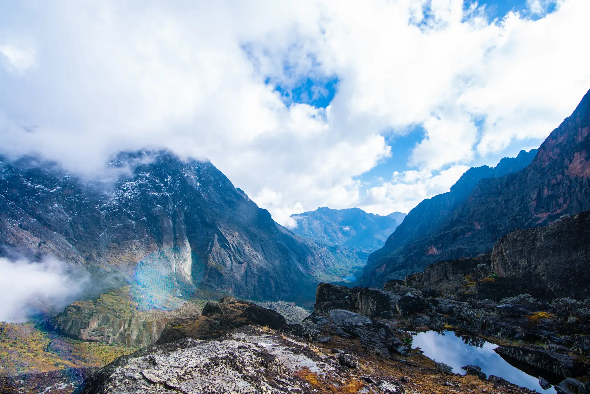
The Rwenzori Mountains are unlike any other mountain range in Africa. Where Kilimanjaro is a broad volcanic cone climbed by roughly 50,000 trekkers per year, the Rwenzori receives fewer than 1,500 visitors annually, meaning you will share the trail with almost no one. The mountain’s UNESCO World Heritage status is not ceremonial; the vegetation zones here are scientifically extraordinary, transitioning from dense montane forest through bamboo groves, giant heather, and otherworldly Afro-alpine moorland to bare glacial ice, all within a single trek.
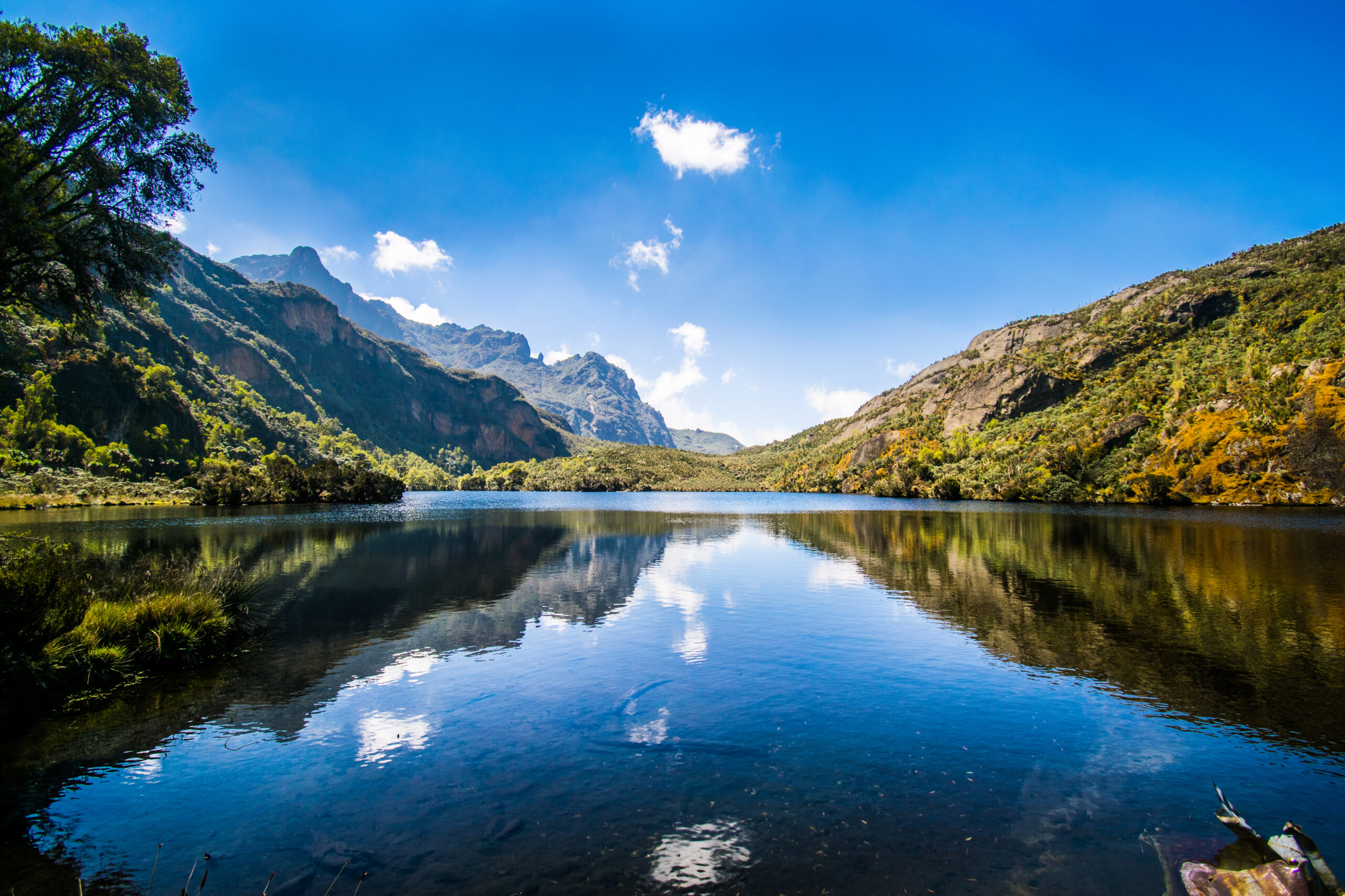
What makes the 6-day version particularly compelling is the inclusion of Kitandara Lakes on Day 4. After summiting Margherita Peak in the pre-dawn dark and standing on the roof of Uganda with the Congo Basin spread below you, the descent past the twin Kitandara Lakes, shimmering blue at 4,027 m amid a world of rock and mist, is one of the most beautiful post-summit rewards in African mountaineering. You will then cross Freshfield Pass on Day 5 before following the historic route past the Duke of Abruzzi’s 1906 base camp at Bujongolo rock shelter, connecting you to the mountain’s remarkable exploration history.
The Rwenzori’s glaciers have retreated by over 80% in the last century, and scientists predict total ice loss by 2050. If summiting an equatorial glacier is on your bucket list, the window to do it is closing. The 6-day Margherita Peak trek is the most time-efficient way to stand on that glacier and come back changed.
Full Day-by-Day Itinerary: 6-Day Rwenzori Trek to Margherita Peak
Day 1: Nyakalengija (1,600m) to John Matte Hut (3,420m) | ~12 km | ~7–8 hrs
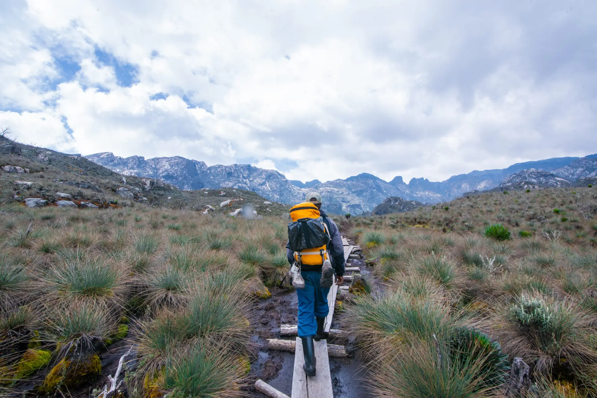
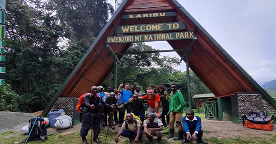
Your Rwenzori adventure begins at Nyakalengija, the park entry point at 1,600m on the eastern flanks of the range. Here, after the park briefing by Uganda Wildlife Authority rangers, you collect your rubber boots, mandatory footwear on the Rwenzori, meet your lead guide and porter team, and take your first steps into the forest.
The first hour follows a wide, gently rising path through cultivated land before the trail plunges into one of equatorial Africa’s most intact montane forests. The canopy closes overhead. The calls of the turaco echo off the mossy trunks. The air is heavy, green, and cool. At roughly the 3 km mark you reach Nyabitaba Hut (2,652 m), the first camp on the Central Circuit where many trekkers on shorter itineraries spend their first night. On the 6-day schedule, you pause here for lunch and then push on.
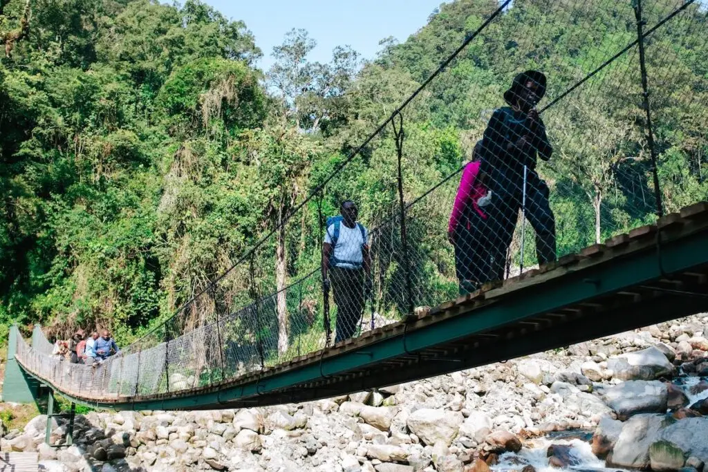
The trail now descends sharply to the Kurt Schaffer Bridge, a spectacular wooden crossing over the confluence of the Mubuku and Bujuku rivers, before rising steeply into the bamboo zone. Giant bamboo towers overhead, the ground becomes rootier and muddier, and the forest transitions into a wilder, more primeval character. You work through rocky sections along the Bujuku River before arriving at John Matte Hut (3,420 m), which is perched above the river and surrounded by tree-heather festooned with hanging lichens. Dinner and a well-earned rest.
Elevation gain: approx. +1,820m. Terrain: forest path, bamboo zone, river crossing, rocky riverbank. Sleep: John Matte Hut. Meals: Packed lunch on trail; hot dinner at hut.
| 📷 Photo Spot: Keep your camera accessible on this first day. The black-and-white colobus monkey is frequently spotted near the forest entry, and the Kurt Schaffer Bridge is one of the most photographed locations on the mountain. |
Day 2: John Matte Hut (3,380m) to Bujuku Hut (3,962m) | ~8 km | ~5–6 hrs
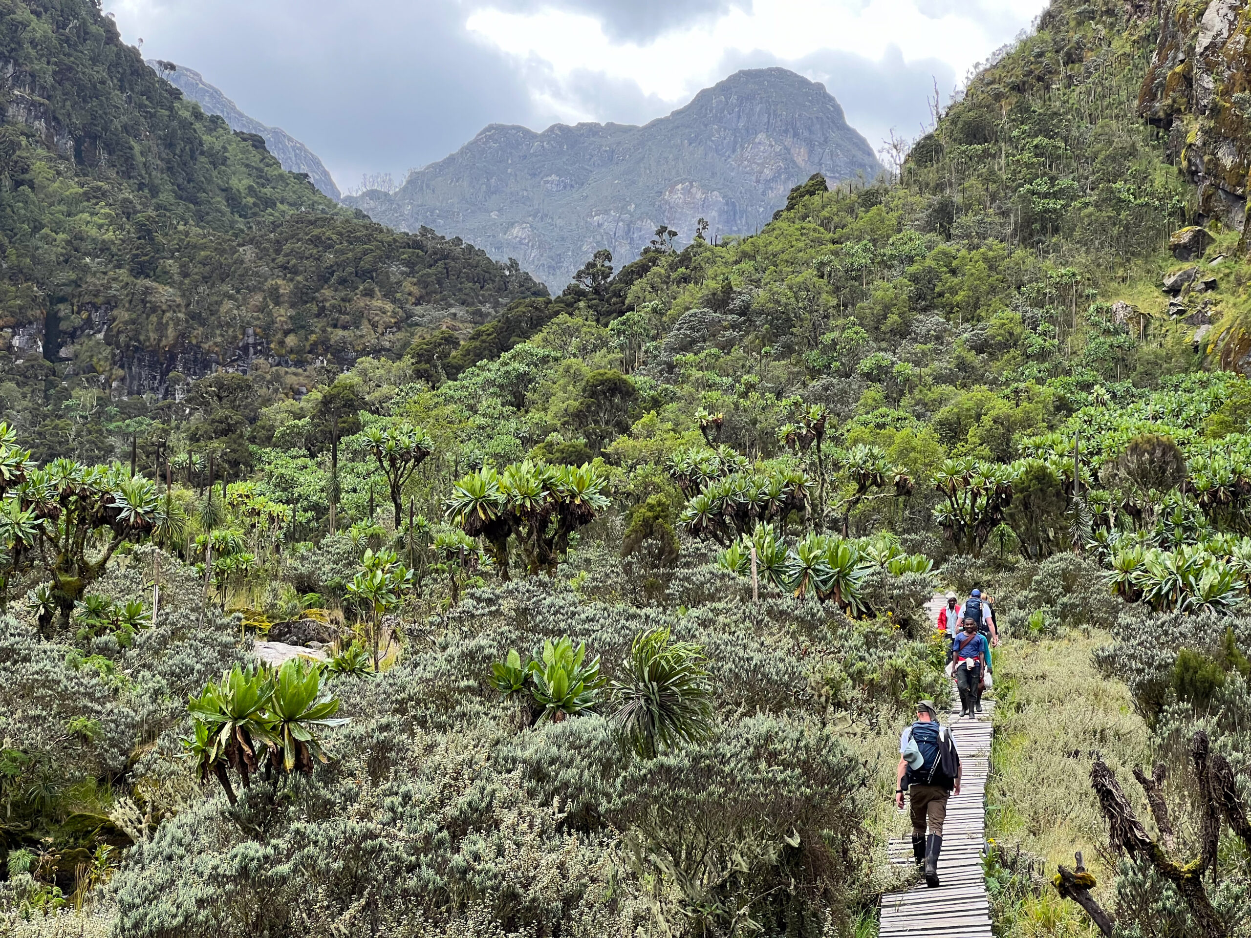
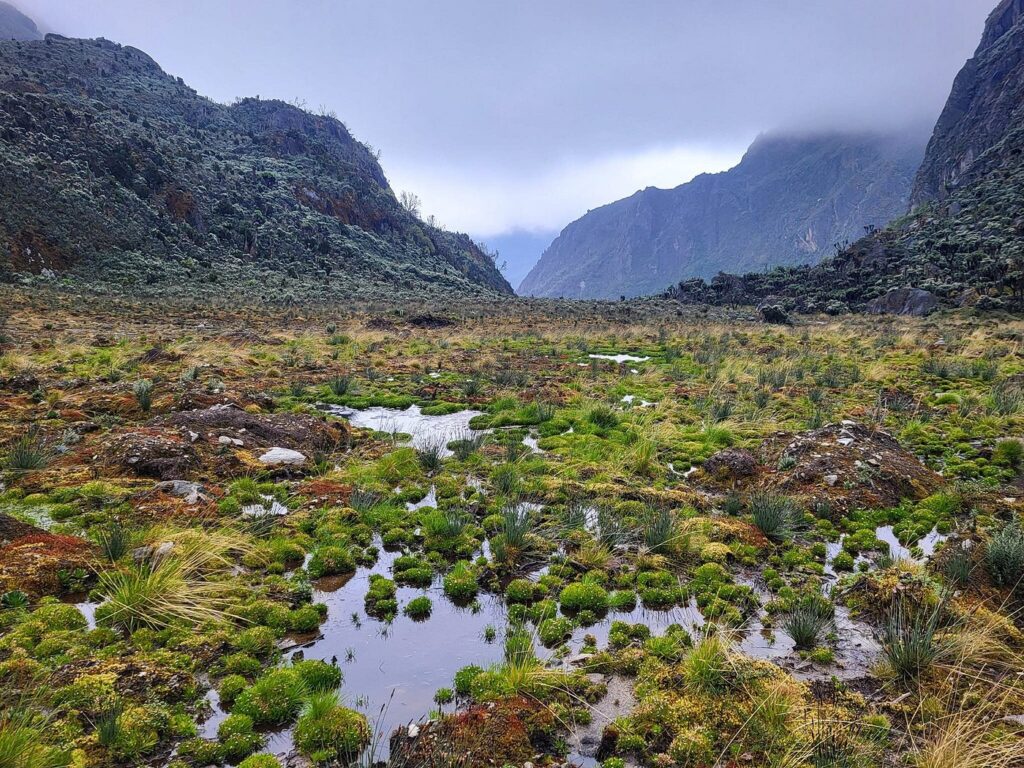
Day 2 is the day the Rwenzori reveals its alien character. Leaving John Matte Hut after breakfast, the trail descends briefly to cross the Bujuku River before arriving at the Lower Bigo Bog, a vast, waterlogged valley carpeted with giant lobelias (Lobelia wollastonii) standing 3–4 metres tall. A wooden boardwalk threads through this surreal landscape, but expect your boots to find the bog regardless. The Rwenzori’s infamous mud is part of the experience; the rubber boots are not optional.
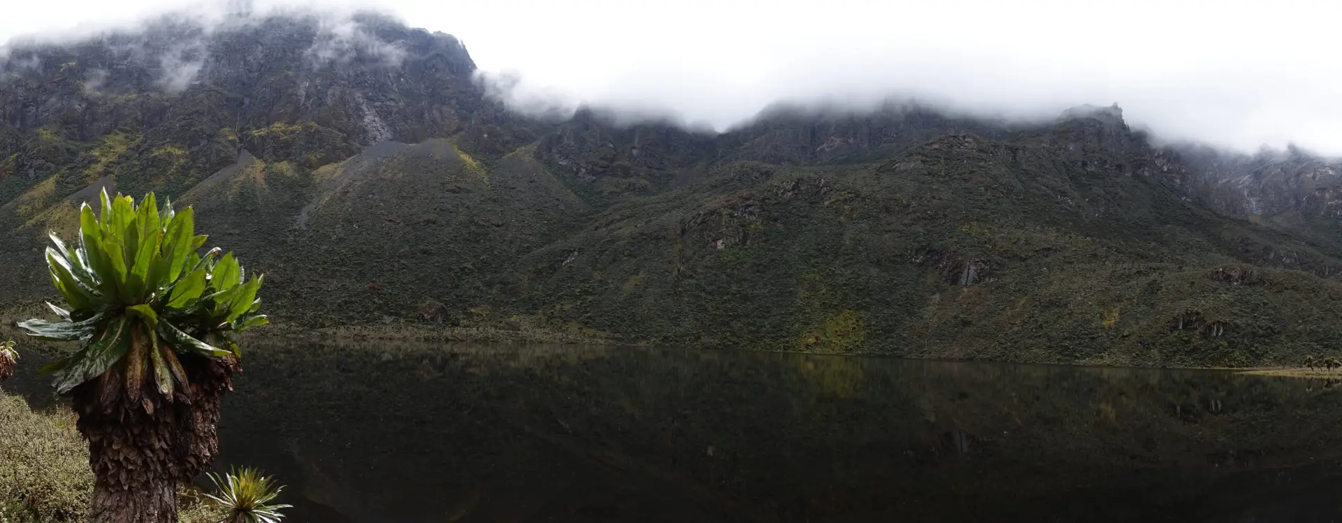
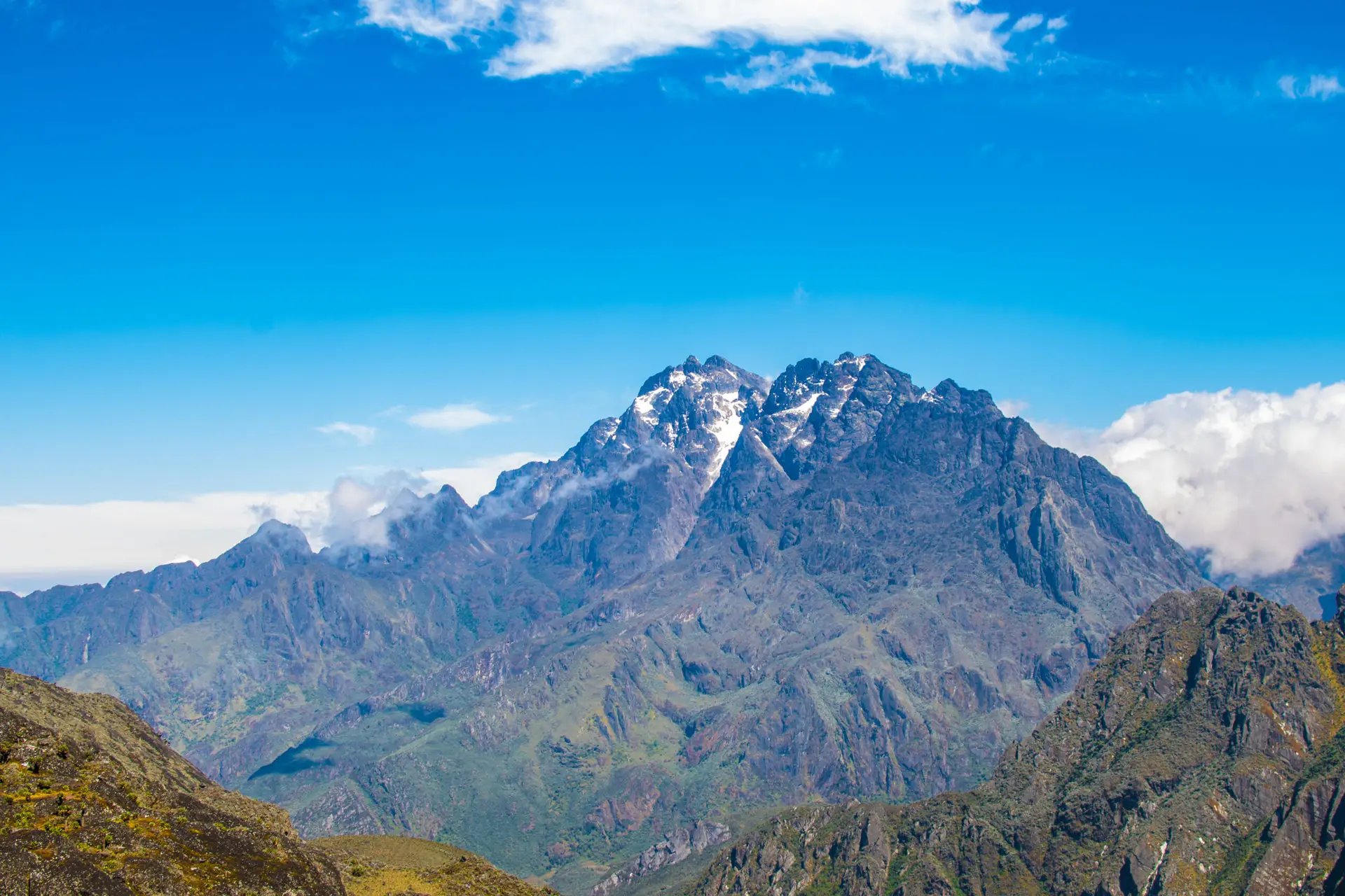
A steep, wooded climb brings you to the Upper Bigo Bog and then into the Bujuku Valley proper, the heart of the Central Circuit. The scale of the landscape shifts here: the valley is vast and open, the sky feels enormous, and for the first time you get your first clear views of Mount Baker (4,843m) and Mount Stanley looming to the south and west, their summits often wreathed in cloud. Lake Bujuku, a glassy high-altitude lake framed by rocky ridges, comes into view just before the hut.
Bujuku Hut (3,962m) sits at the junction of several major routes. Trekkers attempting Mount Speke (4,890m) use the hut as their staging camp. Tonight, spend time at the hut acclimatizing, hydrating well, and resting your legs before the big push that begins tomorrow.
Elevation gain: approx. +580m. Terrain: valley bog, boardwalk, open alpine moorland. Sleep: Bujuku Hut. Meals: Breakfast and dinner at huts; packed lunch on trail.
Day 3: Bujuku Hut (3,977m) to Elena Hut (4,430m) | ~5 km | ~4–5 hrs
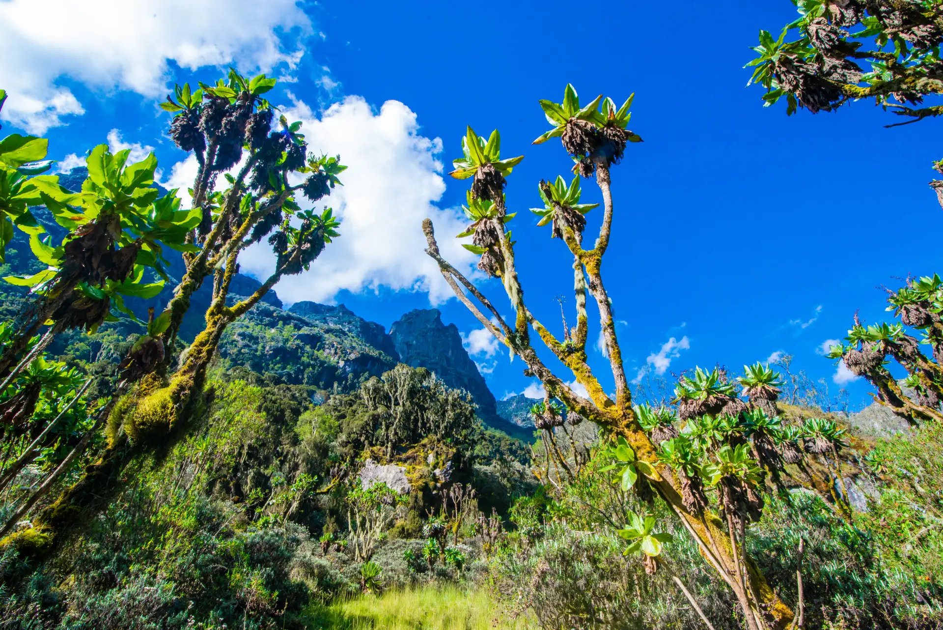
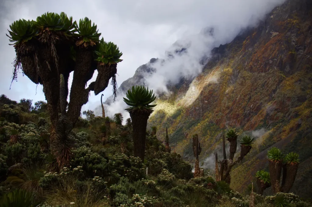
This is your summit preparation day, and it is deliberately shorter and less physical than the days before or after. The trail climbs from Bujuku Hut through a towering forest of giant groundsels (Senecio adnivalis), massive, prehistoric-looking plants that appear to belong to another planet, before the gully that gives ‘Groundsel Gully’ its name narrows and steepens.
At the top of the gully, the trail branches. You are now approaching Scott Elliot Pass at 4,372 m, the highest point of the Central Circuit route. From the pass, on a clear day, the panorama is staggering: the Bujuku Valley falls away behind you, Mount Baker rises to the south, Mount Luigi di Savoia stands to the northwest, and the Stanley Plateau glacier shimmers above.
From Scott Elliot Pass, the trail drops slightly and then climbs again across rocky, often icy terrain to reach Elena Hut at 4,430 m. The hut is small, perched on a ridge above the glacier, and exposed to wind and cold. This is base camp for tomorrow’s summit. Eat a large early dinner, prepare your technical summit gear with your guide, set your alarm for 3:00 AM, and sleep as much as you can.
Elevation gain: approx. +450m net. Terrain: steep groundsel forest, rocky alpine ridge, and icy path sections near the hut. Sleep: Elena Hut. Meals: Breakfast at Bujuku; hot dinner at Elena.
| ⚠ Guide Warning: Your guide will fit you with your harness, glacier gear, and crampons (if conditions require) this evening. Ask any technical questions tonight. Once you are on the Stanley Glacier at 4,500 m in the dark, you want no surprises. |
Day 4: Elena Hut (4,541m) → Margherita Peak (5,109m) → Kitandara Hut (4,027m) | ~14 km | ~12–14 hrs total
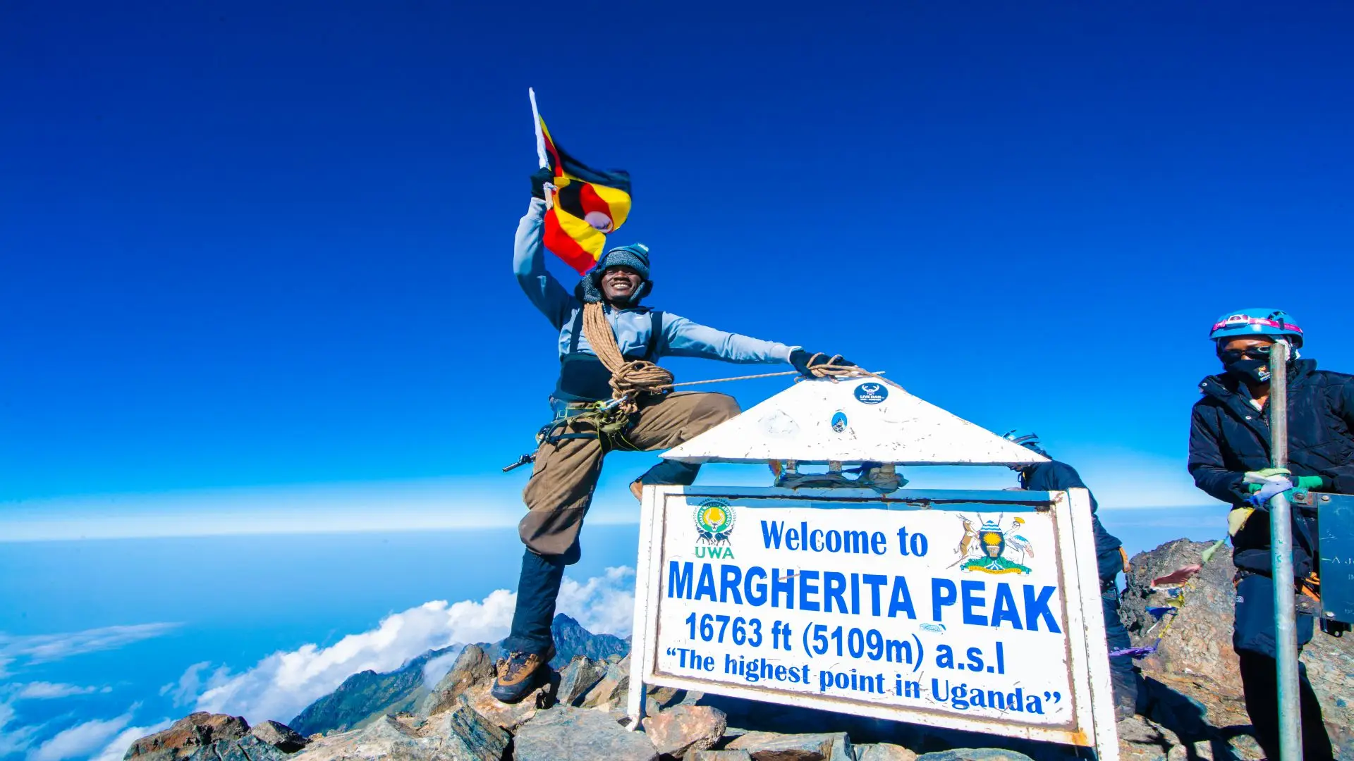
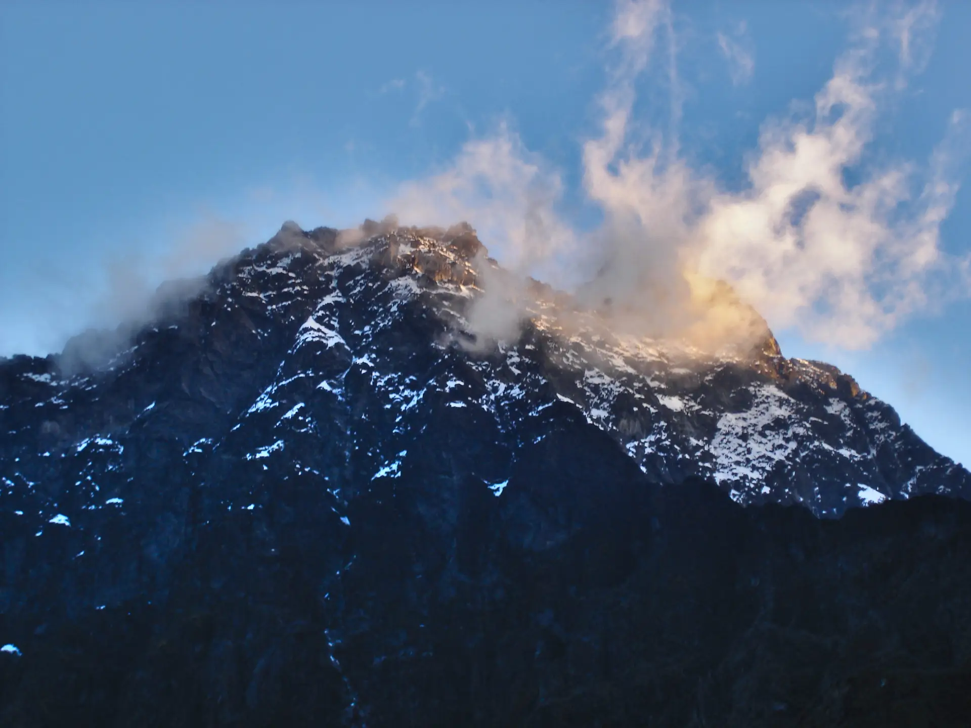
This is the day. Summit day. The alarm sounds at 3:00 AM, and by 3:30 AM you are roped up and moving by headlamp, stepping onto the Stanley Glacier with your guide leading. The cold at this altitude before sunrise is serious; temperatures often drop to -5°C or below, and the silence is absolute except for the crunch of crampons on snow and ice.
The ascent to Margherita Peak takes between five and seven hours depending on conditions and your pace. The route crosses the Stanley Plateau, a broad, crevassed glacier at approximately 4,900 m before the final steep push to the summit. This section requires your guide’s direct instruction and the use of fixed lines on some sections of exposed rock and ice. It is technical, demanding, and utterly breathtaking.
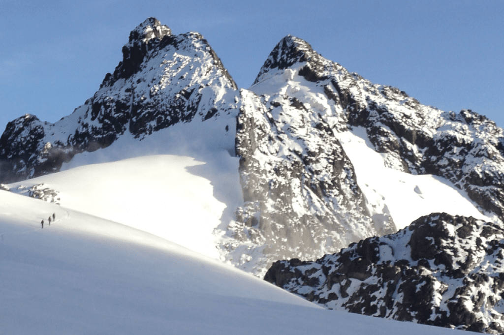
At 5,109m, Margherita Peak is Africa’s third-highest point, behind only Kilimanjaro and Mount Kenya. The summit view on a clear morning, the Congo Basin to the west, the Ugandan savanna to the east, and the other Rwenzori peaks clustered below, is one of the great payoffs in African travel. You have earned this reward.
After summit photographs and a brief rest, the descent begins. You reverse the glacier route to Elena Hut, collect packed lunches, and then continue the long descent via Scott Elliot Pass and down the Bujuku Valley side to Kitandara Hut (4,027m) beside the famous Kitandara Twin Lakes. These two pristine glacial lakes, framed by rocky alpine ridges, provide one of the most spectacular campsite settings on the mountain. Dinner here is well-deserved.
Total elevation: +568m ascent from Elena to summit; -2,082m total descent to Kitandara. Terrain: glacier, snow, ice, rocky alpine, and moorland. Sleep: Kitandara Hut. Meals: Hot breakfast at Elena (3:00 AM start, light snack before departure); packed lunch on descent; dinner at Kitandara.
| 📊 Success Rates: The Rwenzori summit success rate is high when trekkers are properly acclimatized and guided. Read our dedicated page on summit success rates to understand what most influences your outcome. |
Day 5: Kitandara Hut (4,027m) to Guy Yeoman Hut (3,450m) via Freshfield Pass (4,282m) | ~10 km | ~6–7 hrs
After the exhilaration and exhaustion of summit day, Day 5 is a long but rewarding traverse. The morning begins with the steepest climb of the descent phase: the trail from Kitandara Hut rises sharply up the southern face of Mount Baker, ascending the dramatic headwall above the lakes to reach Freshfield Pass at 4,282m. This climb is tough on weary legs, and the views back over the Kitandara Lakes as you gain elevation are extraordinary.
From the pass, the trail descends through high alpine mossy vegetation, a landscape of cushion plants, everlasting flowers (Helichrysum sp.), and dwarf heathers before reaching Bujongolo Rock Shelter, the historic base camp used by the Duke of Abruzzi during his 1906 first ascent expedition. A plaque marks the spot. Standing here, sheltered by the same overhang that housed the duke’s porters over a century ago, is one of those quiet moments of connection that make mountain travel meaningful.
The descent continues steeply through heather forest to Guy Yeoman Hut at 3,450m, which sits in a clearing with wide views across the valley. This is your final night on the mountain.
Elevation: +255m to pass; -832m descent to the hut. Terrain: steep rocky headwall, high alpine mossy trail, and heather forest. Sleep: Guy Yeoman Hut. Meals: Breakfast and dinner at huts; packed lunch on trail.
Day 6: Guy Yeoman Hut (3,450m) to Nyakalengija (1,600m) | ~14 km | ~6–7 hrs
The final day descends the Mubuku Valley, a long, muddy, and sometimes steep trail that requires careful footing but delivers you off the mountain with a final sweep of the Rwenzori’s lower-altitude wonders. The trail negotiates the Kichuchu cliffs and then follows the Mubuku River downstream, crossing it twice on stepping-stone routes through boggy ground. Miss a tussock and you will get a boot full of Rwenzori bog; it is almost a rite of passage.
After the river crossings, the trail climbs briefly to Nyabitaba Hut (2,652 m), where you spent a lunch stop on Day 1, now a nostalgic marker, and then descends through the montane forest past Mihunga Gate to the trailhead at Nyakalengija. The park’s exit register is signed, certificates are sometimes awarded, and a vehicle returns you to Kasese for a hot shower, cold beer, and a proper meal.
Elevation loss: approx. -1,850m. Terrain: muddy valley path, river crossings, montane forest descent. Meals: Breakfast at hut; lunch at Nyabitaba; transfer to Kasese.
Elevation Profile Summary
The 6-day itinerary is one of the most dramatic elevation arcs in East African trekking. Beginning at 1,600 m, the route rises steeply and continuously over three days to reach 5,109 m on Day 4 before a two-day descent back to the valley floor. The total cumulative elevation gain across the trek is approximately 4,950m, with a corresponding loss of roughly 4,900m.
| Day | Start Camp & Elevation | End Camp & Elevation | Gain/Loss | Distance |
| Day 1 | Nyakalengija, 1,600 m | John Matte Hut, 3,420 m | +1,820 m | ~12 km |
| Day 2 | John Matte, 3,380 m | Bujuku Hut, 3,962 m | +582 m | ~8 km |
| Day 3 | Bujuku Hut, 3,977 m | Elena Hut, 4,430 m | +453 m | ~5 km |
| Day 4 | Elena Hut, 4,541 m | Margherita 5,109 m / Kitandara 4,027 m | +568 m / -2,082 m | ~14 km |
| Day 5 | Kitandara, 4,027 m | Guy Yeoman Hut, 3,450 m | +255 m / -832 m | ~10 km |
| Day 6 | Guy Yeoman: 3,450 m | Nyakalengija, 1,600 m | -1,850 m | ~14 km |
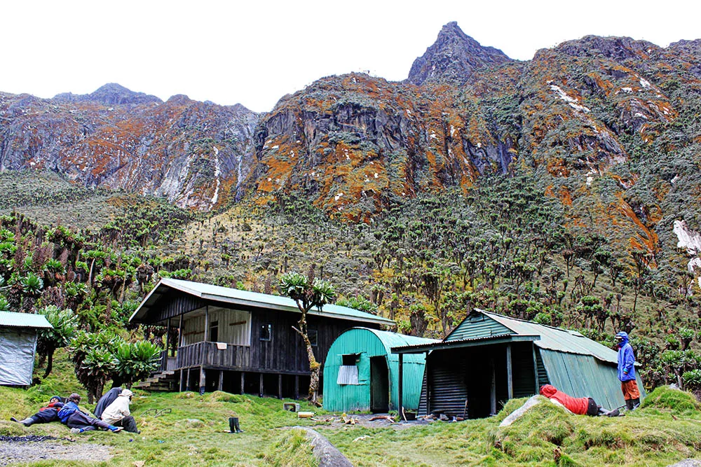
Camps and Mountain Huts on This Itinerary
All accommodation on the 6-day itinerary is in wooden mountain huts managed by the Uganda Wildlife Authority (UWA). Huts provide mattresses, blankets, and a communal meal preparation area. Our guides cook all meals on the mountain. Conditions are basic but functional; these are expedition huts, not lodges. For full details on what to expect at each camp, see our Mountain Huts & Accommodation Guide.
Nyabitaba Hut | 2,652m
Perched in thick montane forest above the Kurt Schaffer Bridge confluence, Nyabitaba is the first camp on the Central Circuit and the last on the way out. It has two sleeping huts and a cooking area. On the 6-day itinerary, you pass through for lunch on Day 1 and use it as a rest stop on Day 6.
John Matte Hut | 3,420m
Set above the Bujuku River in tree-heather moorland, John Matte is a comfortable two-hut camp with river views and the sound of rushing water at night. Your first genuine high-altitude sleep. Meals are cooked by your guide in the camp kitchen.
Bujuku Hut | 3,962m
The junction camp of the Central Circuit, Bujuku Hut, sits on a flat shelf above Lake Bujuku with views of Mount Baker, Mount Stanley, and on clear days, Mount Speke. Three sleeping huts and a cook hut. A well-used and atmospherically alpine camp.
Elena Hut | 4,430m–4,541m
The highest sleeping camp on the Central Circuit and your summit base camp. Elena Hut is small, cold, and exposed, but that is precisely what it needs to be. Only a handful of trekkers are here at any one time. The proximity to the Stanley Glacier, visible from the hut door, makes for a powerful atmosphere on your summit eve.
Kitandara Hut | 4,027m
Perhaps the most scenically positioned camp on the entire route, Kitandara Hut sits beside the Twin Kitandara Lakes at the foot of Mount Baker’s western slopes. The lake views at sunset and sunrise on the rare days when the cloud lifts are extraordinary. After summit day, this is precisely the kind of restorative camp you need.
Guy Yeoman Hut | 3,450m
Named for the British botanist who studied the Rwenzori’s unique flora, Guy Yeoman Hut is a simple, comfortable camp set in heather moorland. It marks the beginning of the final descent and offers wider valley views than the higher camps. Your last night on the mountain.
Flora and Wildlife You Will Encounter
The Rwenzori’s vegetation zones are one of the mountain’s defining features and one of the primary reasons it holds UNESCO World Heritage status. No other mountain in Africa compresses so many distinct ecological communities into a single day’s walk. The wildlife guide on our site covers each zone in detail, but here is what to expect on this specific itinerary.
Montane Forest (1,600m–2,600m)
On Days 1 and 6, the trail passes through dense montane forest. Expect black-and-white colobus monkeys, African green pigeons, various hornbill species, and the raucous call of the Ross’s turaco. The tree canopy is dominated by Podocarpus, Hagenia, and Dombeya species draped in Usnea lichen, old man’s beard, giving the forest an ethereal moss-cathedral atmosphere.
Bamboo Zone (2,600m–3,000m)
A transitional band of giant bamboo (Arundinaria alpina) defines the upper forest. Light filters through in shafts, the trail becomes rooty and muddy, and bird calls change to the liquid songs of sunbirds and weavers. Duiker antelope are occasionally seen at forest edges.
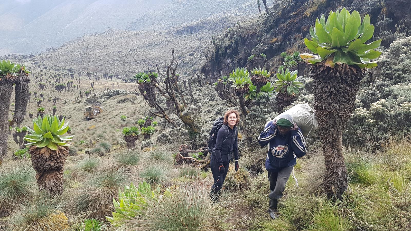
Heather & Lobelia Moorland (3,000m–4,200m)
The surreal heart of the Rwenzori landscape. Giant heathers (Erica arborea) grow up to 6 metres tall, draped in grey-green moss. Giant groundsels (Senecio adnivalis) reach over 5 metres in height, with their cabbage-like tops perched on silver trunks. Giant lobelias (Lobelia wollastonii) emerge from the bogs like botanical skyscrapers. The bogs themselves, particularly the Bigo Bog system, are internationally significant wetland ecosystems.
Afroalpine Zone (4,200m–5,000m)
Above the heather, the landscape becomes rocky and exposed. Cushion plants, everlasting flowers (Helichrysum), and mosses cling to boulder fields. Ravens and Alpine chats are the most common birds. The air is thin, the light is brilliant and harsh, and the silence is complete.
Glacier (above 4,900m)
The Stanley Glacier is an equatorial glacier unique on Earth to a handful of high tropical mountains. Its retreat has been dramatic and documented; the ice you cross on the 6-day Margherita summit is a fraction of what greeted the Duke of Abruzzi in 1906. Read the full glacier report here.
Physical Difficulty, Fitness Requirements, and Acclimatization.
This trek is rated challenging with a technical glacier crossing on summit day. It is not a walk in the park, but it is also not reserved for elite athletes. Our full difficulty guide gives a detailed breakdown, but here is what you need to know specifically for this 6-day itinerary.
Physical Fitness
You should arrive able to hike for 6–8 hours per day with a 6–8 kg daypack over consecutive days. Day 4 (summit day) will involve 12–14 hours of continuous effort at altitude. Prior experience hiking in the mountains, including some multi-day trekking, is strongly recommended. Read our training guide for specific preparation recommendations.
Technical Skills
You do not need any prior glacier or mountaineering experience. Your guide will provide a comprehensive briefing at Elena Hut and will lead and manage all technical sections using ropes and ice axes when conditions require crampons. The ability to follow instructions, move carefully on mixed terrain, and stay calm under pressure is more important than technical skill.
Altitude and Acclimatisation
The 6-day schedule provides reasonable acclimatization, notably better than the 4- or 5-day versions. By sleeping at John Matte (Day 1), Bujuku (Day 2), and Elena (Day 3) before the summit, your body has three nights of progressive altitude adjustment. That said, acute mountain sickness (AMS) is still a real risk above 4,000m. Read our acclimatization guide and our complete medical guide carefully before departure. Our guides carry pulse oximeters and are trained in altitude illness management. If symptoms indicate it is not safe to continue, your guide will descend with you. Summit attempts should never be forced.
Who This Trek Is Suitable For
Fit adults aged 18–65 with hiking experience. Older trekkers in excellent health should read our guide for trekkers over 50. First-time high-altitude trekkers should read our beginner’s guide for realistic expectations. This itinerary is not recommended for those with no prior multi-day hiking experience or cardiovascular health concerns.
Best Time to Do the 6-Day Rwenzori Margherita Trek.
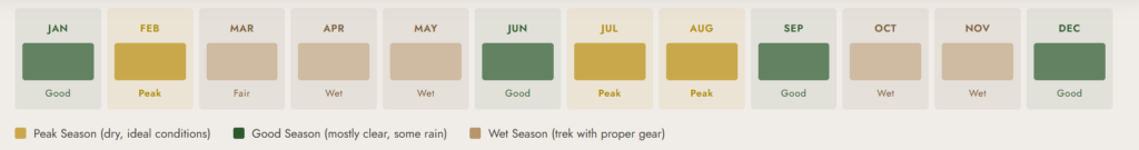
The Rwenzori is a year-round destination; unlike many high mountains, it does not fully close in any season. However, conditions and summit success rates vary significantly by month. Our complete guide on the best times to visit covers these factors in detail. Here is the summary:
| Month / Period | Conditions & Notes |
| December – March | Best dry season. Clearer skies, lower precipitation, and the best summit views. Most popular with international trekkers. |
| June – August | Second dry window. The area has excellent conditions, impressive summit success rates, and is popular with European summer travelers. |
| April – May | Heaviest rains. Trails have become significantly muddier, and clouds often obscure the summit. Success rates drop, but the flora is extraordinary and the mountain is empty. |
| September – November | Transitional period. Variable conditions. Shorter showers are typical rather than sustained rain. A reasonable alternative if dry-season dates are unavailable. |
The Rwenzori receives rainfall in every month of the year; the region is a permanent cloud forest ecosystem, not a seasonal one. Waterproof gear is essential in any season. The question is not whether it will rain, but how much and how often.
What’s Included and What’s Not Included
What’s Included
- Professional UWA-licensed English-speaking mountain guides throughout
- Experienced porter team (carrying up to 15 kg of your gear per porter)
- All meals on the mountain: breakfast, packed lunch, and hot dinner every day
- Accommodation in mountain huts (mattresses and blankets provided)
- Technical summit equipment: ropes, ice axes, helmets, harnesses
- Free use of rubber boots (mandatory Rwenzori footwear)
- Park entry fees and camping/hut fees
- Briefing at Nyakalengija with UWA rangers
- Emergency first-aid kit including pulse oximeter and altitude illness medication
What’s Not Included
- Tips and gratuities for guides and porters (see our tipping guide)
- Personal expenses: drinks, snacks, souvenirs
- Medical evacuation and travel insurance this is mandatory; see our insurance guide
- Accommodation in Kasese or Fort Portal before and after the trek
- Transport to/from the trailhead (can be arranged on request)
- Personal climbing gear: crampons, walking poles, cold-weather sleeping bag
Full Packing and Gear List
The Rwenzori has specific gear requirements that differ from most tropical mountain treks. The combination of permanent moisture, bog terrain, near-freezing high-altitude temperatures, and technical glacier conditions demands careful preparation. Our full packing list guide goes into extensive detail; the essentials for the 6-day Margherita itinerary are:
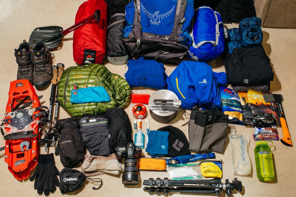
Footwear
Rubber boots are mandatory on the Rwenzori, no exceptions, and are provided free of charge. Bring your own well-worn, waterproof hiking boots for the forest approach sections. Read our dedicated boot selection guide for detailed recommendations.
Insulation
You will sleep at up to 4,541 m. A sleeping bag rated for at least -5°C to -10°C is required. You will need multiple thermal layers, including synthetic or merino wool base layers, a mid-layer fleece, and an insulated jacket. See our warm-layering guide for a full layering strategy.
Waterproof Clothing
- Waterproof shell jacket (fully taped seams, not just water-resistant)
- Waterproof shell trousers
- Waterproof gloves glacier-weight for summit day; lighter for approach days
- Waterproof cover for your daypack
Summit Day Specifics
- Warm hat and balaclava (summit temperatures can reach -10°C before dawn)
- Glacier glasses / ski goggles (UV protection critical on glacier)
- Trekking poles with snow baskets
- Headlamp with fresh lithium batteries (3:00 AM start this is non-negotiable)
- Hand warmers
Daily Essentials
- Refillable water bottles or hydration bladders (minimum 2 litres capacity)
- Water purification tablets or filter
- Sunscreen SPF 50+ and lip balm
- Blister kit and personal first aid
- Camera and spare batteries (cold kills battery life rapidly)
- Trekking poles
- Snacks: chocolate, nuts, dried fruit, energy gels for summit day
Rwenzori Permits, Park Fees and Costs
The Uganda Wildlife Authority (UWA) manages all trekking in the Rwenzori Mountains National Park. Fees are collected at the park gate and are included in our package price. Our full cost breakdown guide for 2025/26 gives exact current figures. Here is the overview:
| Fee Category | Approximate Amount (USD) |
| Park Entry Fee (per day) | $35–$40 per person per day |
| Mountain Hut / Camping Fee | Included in park daily fee |
| Lead Guide Fee | Included in package |
| Porter Fees (per porter per day) | Included in package |
| Technical Equipment (ropes, axes) | Included in package |
| Rubber Boot Hire | Included free of charge |
| TOTAL Package Price (indicative) | From USD 1,400 per person |
| 💰 Pricing Note: Prices vary with group size, season, and any customization. Contact us for an exact, no-obligation quote tailored to your group. |
Getting to the Rwenzori Mountains Trailhead
Our full Getting to the Rwenzori guide covers all options in detail. Here is the practical summary:
From Kampala / Entebbe
The trailhead at Nyakalengija is approximately 370 km from Kampala, a 5–6 hour drive on the Kampala–Kasese highway via Fort Portal. We can arrange private transfers from Kampala or Entebbe International Airport. Public post buses and shared taxis (matatus) to Kasese are available but require a local transfer to Nyakalengija.
From Kasese
The gateway town of Kasese is 13 km from the Nyakalengija trailhead. A boda-boda (motorbike taxi) or private hire vehicle from Kasese takes 20–30 minutes. We recommend arriving in Kasese the evening before your trek starts to allow time for a final gear check and early morning departure.
From Fort Portal
Regular shared taxis serve Fort Portal, which is approximately 70 km north of Kasese. Many trekkers combine a Rwenzori expedition with a visit to the crater lakes region or chimpanzee trekking in Kibale Forest at either end of the trek.
Accommodation Before the Trek
We recommend at least one night in Kasese before and after the trek. Our pre- and post-trek accommodation guide lists the best hotels and guesthouses at a range of price points.
Book Your Trek
Respond within Minutes
From
$1,400
per person
- Duration 6 Days / 5 Nights
- Group Size 1–12 people
- Start Point Nyakalengija
- Departures Year-round
- Summits Margherita Peak
No booking fee. Free cancellation up to 30 days before departure. We respond within Minutes.
Our Popular Rwenzori Treks
Magheritah Peak (8 Days Kilembe Trail)
$1705 Per Person
Mutinda LookOut (4 Days)
$645 Per Person
Short Magherita Hike (5 Days Central Circuit)
$1200 Per Person
Rwenzori Hike (7 Days Central Circuit)
$1400 Per Person
Frequently Asked Questions: 6-Day Rwenzori Trek to Margherita Peak.
How difficult is the 6-day Rwenzori Margherita Peak trek for a first-time trekker?
The 6-day Rwenzori trek to Margherita Peak presents a challenging experience, including a technical glacier crossing on summit day. First-time trekkers with good baseline fitness and prior multi-day hiking experience can complete this trek successfully. However, if you have no experience on extended trails, consider our beginners’ guide and potentially start with the 7-day version for additional acclimatization. The technical sections, glacier crossing, and steep rocky terrain at altitude are fully guided and roped, so you do not need any prior mountaineering experience.
Is there a difference between the 6-day and 7-day Margherita Peak trek?
The primary difference is one extra acclimatization day. The 7-day version typically includes a rest day at Bujuku Hut before the ascent to Elena, giving your body additional time at 3,900m before the summit push. This improves summit success rates and is the recommended option for trekkers who have concerns about altitude sensitivity. The 6-day version is appropriate for fit, acclimatization-resilient trekkers. Our acclimatization guide can help you decide which is better for you.
Do I need prior glacier or mountaineering experience for the Rwenzori summit?
No prior glacier experience is required. Your guide provides a complete technical briefing at Elena Hut the evening before the summit, and all technical sections the Stanley Plateau glacier, any fixed-line sections on summit rock and ice are managed with ropes by your guide. You need to be able to follow instructions carefully and move calmly on mixed terrain, but you are not expected to have any prior alpine skills.
What is the success rate for summiting Margherita Peak on the 6-day itinerary?
When trekkers are thoroughly prepared, they typically achieve high summit success rates on the 6-day itinerary, usually between 70% and 85%, depending on conditions and individual fitness. The main reasons for not summiting are altitude sickness and severe weather. Our guide on summit success rates explains the factors in detail. The single biggest influence on success is prior acclimatization: arriving from sea level the day before the trek is not ideal. We strongly recommend at least 48 hours in Uganda at moderate elevation before starting.
What are the weather conditions like on the Rwenzori Central Circuit in the dry season?
Even in the peak dry season (December–March and June–August), the Rwenzori receives some rain almost every day. “Dry season” on this mountain means fewer heavy, prolonged rains and better summit visibility, not rain-free conditions. Mornings are typically clearer; clouds often build by midday, and afternoon rain is common. Temperatures range from around 20°C in the forest to -5°C or below on the summit glacier at night. Our best time to visit guide has month-by-month details.
How much does the 6-day Rwenzori Margherita Peak trek cost?
The all-inclusive package price starts at approximately USD 1,400 per person for groups of 2 or more, covering all guide and porter fees, hut accommodation, meals, technical equipment, rubber boot hire, and park fees. Solo bookings and smaller groups will be priced differently. Our full cost breakdown guide explains every component of the fee structure. Contact us for an exact personalized quote.
What kind of travel insurance do I need for the Rwenzori Margherita Peak trek?
You must have travel insurance that specifically covers mountain trekking to 5,200m and includes emergency medical evacuation. Standard travel insurance does not cover helicopter evacuation from a remote mountain at 4,500m. Our travel insurance guide lists the specific cover you need and recommends insurers with proven track records for Rwenzori-altitude evacuation.
What do I eat and drink on the mountain during the 6-day trek?
Our guides prepare all meals at each hut: hot breakfast, packed lunch for the trail, and a hot three-course dinner each evening. Expect hearty mountain cooking with local staples maize, porridge, chapati, rice, beans, lentils, eggs, and vegetables. Drinking water is sourced from mountain streams and treated before use. We recommend bringing your electrolyte tablets and high-energy snacks for summit day.
How does the 6-day Central Circuit compare to the 8-day Kilembe Trail for reaching Margherita Peak?
The 8-day Kilembe Trail approaches the mountain from the south through the old copper mining town of Kilembe, offering an entirely different perspective on the Rwenzori range. It has more sustained waterfalls in the lower sections and tends to be less muddy than the Central Circuit. The Central Circuit, by contrast, is the classic, longer loop that visits more of the mountain’s iconic valleys and camps. For a detailed comparison, see our Central Circuit vs Kilembe Trail guide.
Can I see gorillas on a trip that includes the 6-day Rwenzori trek?
Absolutely. Uganda is home to both the Rwenzori Mountains and Bwindi Impenetrable Forest, the world’s top destination for gorilla trekking. Combining a 6-day Margherita Peak climb with a gorilla trekking experience is one of the most remarkable adventure itineraries in Africa. Our 12-day Rwenzori and Gorilla Trekking combination does exactly that. Contact us to build a custom itinerary that fits your schedule.
How safe is the 6-day Rwenzori trek?
When you undertake the Rwenzori with a licensed operator, you will find it one of the safer high-altitude treks in Africa. Our safety guide covers the full safety record and risk profile. Our experienced, UWA-certified guides manage the main hazards: altitude sickness, hypothermia, and the technical glacier crossing. Our guides carry first aid kits, oxygen, and pulse oximeters on every trek, and we have evacuation protocols in place. Read also our guide to porter services to understand how our support team contributes to mountain safety.
Ready to Summit Margherita Peak? Book Your 6-Day Rwenzori Trek
The 6-Day Rwenzori Margherita Peak trek is one of Africa’s remarkable adventure experiences. Fewer than 1,500 people climb this mountain every year. You will move through a landscape that looks like no other place on Earth, guided by professionals who have summited Margherita Peak hundreds of times, and you will stand on an equatorial glacier that may not exist by 2050. This is not a trip to put off.
Why Trek With Us:
Our guides have completed over 200 Margherita Peak summits. They know this mountain in every season and under every condition. When you trek with Rwenzori Trekking Safaris, you are in the most experienced hands on the mountain.
To book the 6-day Margherita Peak trek or request a personalized quote, contact us through any of the channels below:
WhatsApp (instant reply): +256 773 256 104 | Email: rwenzoritrekkingsafaris@gmail.com
Or use our Contact & Quote Form for a detailed response within 24 hours.
You can also read our full FAQ library (100+ questions answered) or browse all Rwenzori treks and expeditions to find the itinerary that best fits your timeline.
A 10% portion of every trek booking goes directly to supporting local Bakonzo communities through orphan care, school programs, and community housing. When you climb the Rwenzori with us, you contribute to the people who call these mountains home.