Kitandara Lakes: Rwenzori’s Most Beautiful Spot. The Kitandara Lakes: twin glacial tarns at 4,023 m in the Rwenzori Mountains. This guide covers how to reach them, what they look like, photography tips, and a wildlife guide. Many trekkers preparing for the Rwenzori Mountains have asked me which part of the mountains is the most beautiful. It is an impossible question in the sense that every veteran guide answers it differently: the first morning light on the upper Elena glacier, the transition into the giant lobelia forest above John Matte, and the view of Margherita Peak from the summit register. It is an easy question because there is one answer I keep returning to, one that survives comparison with all the others, and one that has stopped even the most trail-hardened trekkers. The Kitandara Lakes.
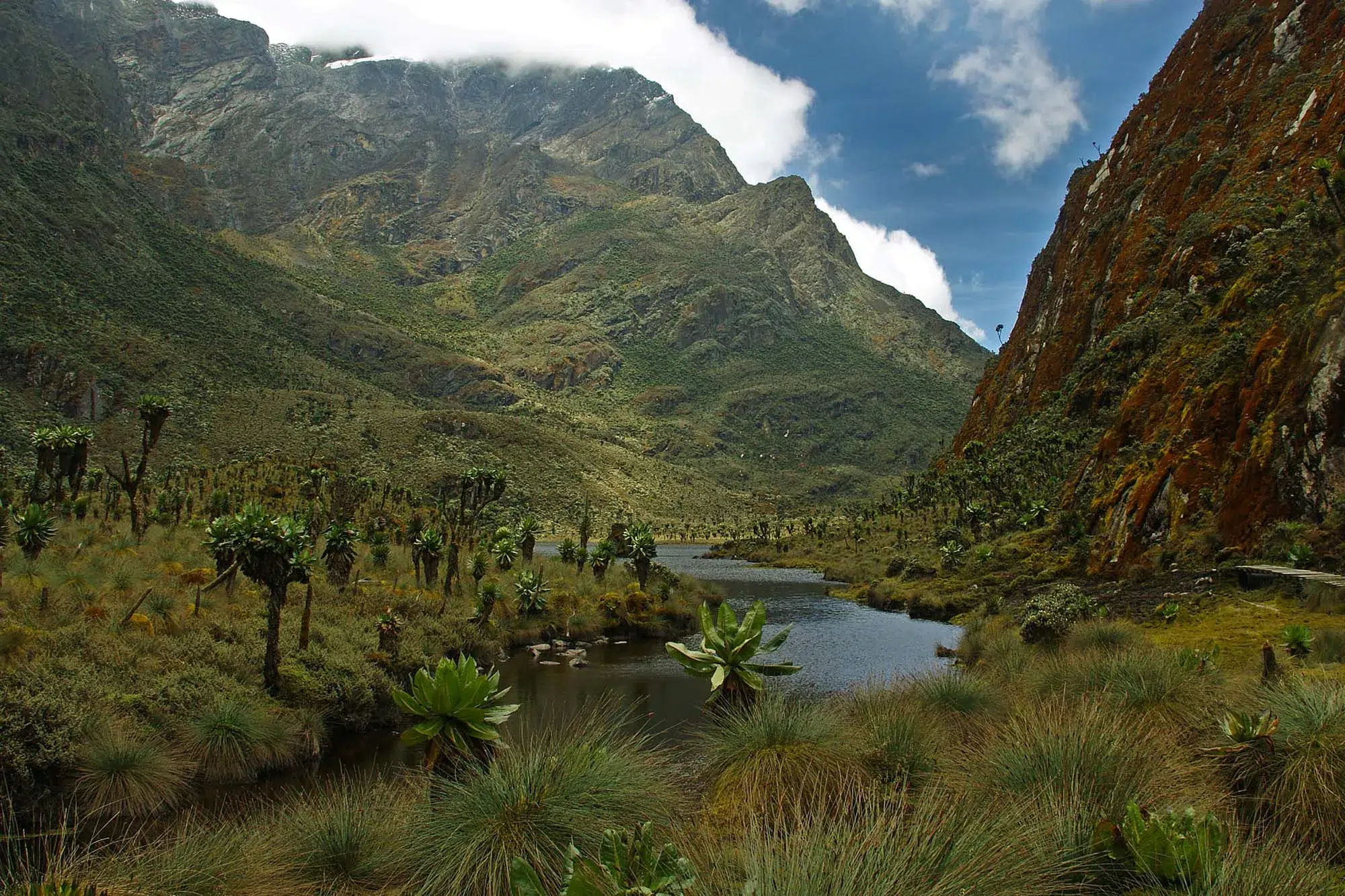
They are twin glacial tarns at 4,023 metres above sea level, set in a broad bowl of Afro-alpine terrain on the south-western flank of the Central Circuit Trail. The upper lake is darker, deeper, and ringed by boulder fields and the silver-grey trunks of giant groundsel. The lower lake is more open, its surface frequently still enough to mirror the surrounding peaks and sky with a precision that makes trekkers stop and look twice at the image they are standing in front of, unsure for a brief, confused moment which direction is up. Between them, the Kitandara Valley floor is a mosaic of bog and rocky moraine, inhabited by giant lobelias and the everlasting flowers of the high alpine. Behind them, when cloud permits, and cloud always, eventually, permits, the dark rock ridges of Mount Baker rise against the sky in a composition that looks, even after many visits, like a landscape painting rather than a view.

This guide is everything you need to know about the Kitandara Lakes: how to reach them, what they look like at every time of day, what the Kitandara Hut experience involves, how to photograph the scene, what wildlife you will encounter on the approaches, and which trekking itineraries give you the time at Kitandara that the place deserves. This guide is intended for trekkers who want to understand what they are walking toward before they arrive, as well as for those who have already been there and recognize the specific quality of stillness at 4,023 metres when the mountain briefly reveals itself.
What Are the Kitandara Lakes? Geography, Formation, and Character
The Kitandara Lakes are twin glacial tarns, lakes occupying depressions carved by the rotational movement of past glaciers in the upper Kitandara Valley on the southwestern section of the Central Circuit Trail. They sit at an altitude of approximately 4,023 metres above sea level, in a broad cirque basin bounded to the northeast by the ridgeline connecting Mount Stanley to the wider circuit route and to the south by the approach to the Freshfield Pass (4,282 metres), beyond which lies the southern Mount Baker massif. The basin in which the lakes sit was carved by the glaciers that occupied the Rwenzori’s upper valleys during the Pleistocene ice ages when the Rwenzori glaciers extended down to approximately 3,500 metres across the range, and the smooth, U-shaped profile of the valley walls is classic glacial morphology.
The upper lake is the smaller of the two: darker, with a more enclosed aspect, surrounded on three sides by rocky moraine deposits left by the retreating glaciers. Its color in calm conditions tends toward a deep blue-grey, reflecting the rock walls of the surrounding basin rather than the sky. The lower lake is larger, more open, and positioned to receive reflections from the broader sky, which, in the morning hours before cloud builds, means a surface that mirrors the peaks above with a stillness and precision that produces the most dramatic reflective photography available anywhere in the Rwenzori range. A small stream connects the two lakes and continues southward into the drainage system that feeds the Mubuku River, part of the Rwenzori’s hydrological contribution to the Albertine Rift lake system.
The Geology of the Lakes: Reading the Glacial Past
The Kitandara basin is a textbook example of glacial geomorphology on a tropical mountain. The bowl shape of the cirque, steep-walled on three sides and opening on the fourth, is produced by the rotational movement of a past glacier whose ice carved into the bedrock through the freeze-thaw cycle of freeze-expansion-melt, which progressively breaks apart rock surfaces over thousands of years. The smooth, rounded outcrops visible above the lake shores are roche moutonnées, rock surfaces abraded smooth by the passing ice, while the rough, angular boulders of the moraine ridges marking the lake margins are the material that the glacier plucked from the up-ice surfaces and carried to its terminus as it retreated.
The geological story of the Rwenzori is written most legibly in places like the Kitandara basin, where the evidence of past glaciation is both large-scale (the basin itself) and small-scale (individual striated rock surfaces and erratic boulders deposited by the retreating ice). Trekkers with geological curiosity can read several chapters of the Rwenzori’s ice age history in an hour’s walk around the lake margins, from the depth of the cirque depression that reveals the thickness of the past ice to the height of the moraine ridges that indicate the glacier’s most recent maximum extent before its final retreat.
The Water: Colour, Clarity, and Seasonal Variation
The color of the Kitandara Lakes changes with atmospheric conditions in ways that reward multiple visits and extended time at the site. On a clear morning, most likely in the drier months of January, February, July, and August, the lower lake’s surface becomes a near-perfect mirror. The surrounding peaks, the clouds moving over them, and the silver-grey groundsel trunks at the water’s edge all appear in the reflection with a fidelity that creates the visual paradox of two landscapes occupying the same space, one above the water and one below. The stillness required for this reflection effect is most common in the first two to three hours after dawn, before the morning thermal convection that begins when the sun hits the basin floor creates enough air movement to break the mirror into ripples.
As clouds build through the morning, a near-universal daily occurrence on the Rwenzori regardless of season, the lake’s color shifts: the sharp blue-grey of a clear-sky reflection becomes a softer, more diffuse silver-white as clouds dominate the sky above. In heavy cloud or fog, the lake takes on a pewter quality, still beautiful and atmospheric in a different register, but no longer the dramatic mirror of the clear-sky morning. In rain, which arrives on most afternoons regardless of the season, the surface dimples with individual drops, the whole lake becoming a texture rather than a reflection, and the surrounding landscape disappearing into a grey intimacy that is its own kind of beautiful.
How to Reach the Kitandara Lakes: Routes, Timing, and Approach

The Kitandara Lakes are accessible on the Central Circuit Trail only; they are not on the Kilembe Trail route and are not accessible as a day trip from the Rwenzori foothills. Reaching the Kitandara basin requires a multi-day expedition commitment, with the lakes typically visited on day five or six of the standard 7-day Central Circuit summit trek as part of the descent route from Elena Hut and Margherita Peak toward the lower mountain. The most common approach is the descent from the Scott Elliot Pass (4,372 metres) via the south-facing trail that drops into the Kitandara Valley, a route that offers, in conditions of reasonable visibility, one of the most dramatic descent panoramas in the Rwenzori range.
The table below summarizes the primary approach routes to the Kitandara Lakes and the practical logistics of each.
| Approach Route | From Camp | Trek Time | Notes |
| Descent from Elena / Scott Elliot Pass | Elena Hut | 3–5 hours | Classic post-summit descent on 7-day Central Circuit; most scenic approach |
| Ascent from Guy Yeoman Hut | Guy Yeoman | 3–4 hours | Reverse direction: ascending to Kitandara on Day 5 of many itineraries |
| Crossing via Freshfield Pass | Kitandara | 3–5 hours | Onward from Kitandara toward Mount Baker on extended multi-peak itineraries |
| Kitandara as base camp (multi-night) | Kitandara Hut | N/A (base) | Best option for photography and Baker summit attempts; requires extended itinerary |
The Approach from Scott Elliot Pass: The Most Dramatic Entry
The most dramatic way to arrive at the Kitandara Lakes is by descending from the Scott Elliot Pass, the col at 4,372 metres that separates the Mount Stanley massif from the Kitandara Valley. Trekkers arriving at Kitandara by this route have typically spent the previous 24 to 36 hours on the upper mountain, crossing the Coronation Glacier on the approach to Margherita Peak, sleeping at Elena Hut at 4,541 metres, and summiting Africa’s third-highest peak before beginning the descent. One of the Rwenzori’s most powerful experiential moments occurs during the psychological and physical transition from the stark, icy world of the summit zone to the sudden visibility of the Kitandara Lakes, which appear in the valley below as the trail descends from the pass.
The descent from Scott Elliot Pass to the Kitandara Hut takes between two and four hours depending on pace and conditions. The trail is well-marked, though the upper section in the vicinity of the pass can be rocky and exposed in poor visibility. As altitude drops from 4,372 metres toward the lake basin at 4,023 metres, the vegetation gradually transitions from the open, minimalist landscape of the highest alpine zone back into the giant groundsel and lobelia communities of the Afro-alpine zone, with the plants becoming progressively more numerous and larger as the trail descends into the more sheltered and wetter basin environment. The moment when the two lakes become visible for the first time, usually through a gap in the groundsel as the trail rounds the last shoulder above the basin, is a specific, memorable instant that trekkers consistently identify in their post-expedition accounts.
Timing Your Arrival for the Best Light
The single most important strategic decision affecting the quality of the Kitandara Lakes experience is the timing of arrival. The reflective photography window , when the lower lake is calm enough to mirror the surrounding landscape, most reliably occurs in the two to three hours after dawn. An arrival at the Kitandara Hut the evening before provides a base from which to be at the lakeside before sunrise the following morning, in position before the thermal convection begins. This is the argument for building a Kitandara overnight stay into your itinerary rather than simply passing through on a single day’s descent.
Standard 7-day Central Circuit itineraries typically reach Kitandara Hut on day five or six and continue the following morning toward Guy Yeoman Hut and the final descent to the trailhead. This means one overnight at Kitandara is sufficient to catch at least one dawn viewing if the weather cooperates. Extended itineraries, the 8-day three-peaks expedition, the 10-day four-peaks trek, and the 13-day six-peaks grand expedition often spend two nights at Kitandara, using it as a base camp for the Freshfield Pass approach to Mount Baker. Two nights at Kitandara is the ideal configuration for those for whom the lakes are a primary destination: two potential dawn windows, time for an afternoon exploration of the upper lake circuit, and the unhurried opportunity to simply be in one of Africa’s most extraordinary mountain landscapes.
Kitandara Hut: Sleeping at the Edge of the Mirror.
Kitandara Hut sits at the southwestern end of the lower lake, positioned to face the water across a short stretch of rocky moraine. The hut is a wooden structure in the standard Central Circuit hut format: bunk frames with foam mattresses, a communal cooking and eating area, and outbuilding latrine facilities, but its setting elevates the standard infrastructure into something considerably more than functional. The view from the hut’s door or from the rocks immediately in front of it, with the lower lake in the foreground, the valley rising toward the Freshfield Pass beyond the upper lake, and Mount Baker’s dark ridges in the middle distance, is the most painterly camp view available anywhere on the Central Circuit.

The hut has limited solar panel infrastructure that can provide basic lighting and opportunistic device charging, though as covered in our full guide on charging electronics at Rwenzori Mountain camps, charging availability at Kitandara is weather-dependent and unreliable as a primary source. At Kitandara, your device management priority should be the camera and phone camera: you are at the scene for your best Rwenzori photographs, and battery reserve is more important here than at any other camp on the route. Ensure your power bank is available and warm; overnight temperatures at 4,023 metres regularly fall to between 2°C and 8°C, and cold-induced battery drain is a real consideration at this altitude.
Water at Kitandara is exceptional. The lake outlet stream provides clear, cold, and reliably clean water that your guide and cook will treat before use. The water quality from glacier-fed alpine tarns at this altitude is among the best on the mountain. Nights at Kitandara carry a particular stillness: the basin is sheltered enough to reduce wind to a whisper on calm evenings, and the absence of any other sound no traffic, no voices beyond your group, no human technology of any kind creates a silence that is its own form of luxury. Sleep at Kitandara is generally excellent, a combination of lower-than-Elena-Hut altitude, physical exhaustion from the preceding summit days, and the particular quietude of a sheltered mountain bowl.
The Kitandara Evening: What Happens After Sunset
The period from late afternoon to dark at Kitandara is one of the Rwenzori’s most atmospherically rewarding time windows, but it often does not appear in the photography guides. The cloud that has dominated the afternoon gradually transforms as the sun drops: what was an undifferentiated grey ceiling earlier in the day breaks apart at the margins, producing the dramatic light of mountain dusk, with shafts of orange and gold breaking through cloud gaps, the lake surface catching color that the midday palette of grey and green never offered, and the groundsel trunks glowing warm against the dark basin walls as the shadows deepen in the moraine.
If the evening clears sufficiently, and even the Rwenzori’s persistently cloud-covered evenings occasionally provide a window of partial clarity, the stars above the Kitandara basin are extraordinary. At 4,023 metres, above most of the atmospheric haze that softens the night sky at lower altitudes, the Milky Way is visible as a dense, textured band of light that trekkers from light-polluted cities perceive as almost implausibly bright. The dark forms of the mountains surrounding the basin block the horizon, creating the impression of a natural amphitheater with the night sky as its ceiling. Astrophotography from the Kitandara lake shore with the star field reflecting in the still water on a calm, clear night is a genuinely extraordinary photographic opportunity that few Rwenzori trekkers specifically plan for but many discover with delight.
Photographing the Kitandara Lakes: A Complete Practitioner’s Guide
The Kitandara Lakes are the most photographed feature of the Central Circuit Trail and among the most photographed natural scenes in all of Uganda’s mountain and wildlife photography. The reflective lake surface, the surrounding alpine vegetation, the peak backdrop, and the extraordinary quality of dawn and dusk light in the basin combine to produce photographic opportunities that require no particular technical sophistication to exploit; almost any camera, in the right conditions, will produce images of compelling quality. But understanding the specific conditions that produce the best results and managing your limited window of clarity to be in the right position at the right moment makes the difference between good Kitandara photographs and unforgettable ones.

The Pre-Dawn Position: Where to Be and When
The most important photographic decision at Kitandara is where to stand for the dawn reflection shot and to arrive before first light. The optimal position for the reflective lower lake shot is on the lake’s eastern shore, shooting westward toward the basin headwall and the mountains beyond. From this position, the reflecting surface of the lake occupies the lower half of the frame, the peak silhouettes and sky the upper half, and the groundsel trunks at the lake margin provide midground texture and a scale reference.
Being in position before first light means leaving Kitandara Hut in darkness, typically between 5:00 and 5:30 am, with a headlamp. The short walk from the hut to the optimal lake shore position takes less than ten minutes, but arriving after the sky has already begun to lighten means missing the pre-dawn blue hour, which many landscape photographers consider the most atmospheric window of all. The fifteen minutes before sunrise, when the sky above the basin begins to distinguish peaks from clouds in a pale grey-blue light, produces images of a quality that the richer colors of direct sunrise cannot always match.
To shoot actively at 5:15 am, you must keep your camera and power bank inside your sleeping bag overnight, rather than in an exposed outer pocket. The 4°C to 8°C overnight temperatures at Kitandara are cold enough to significantly reduce battery capacity if devices are left in the cold for eight hours. A camera battery pulled from a sleeping bag is at something close to full effective capacity; a camera battery pulled from an outer jacket pocket at the same temperature may be showing 60% capacity before you have taken a single photograph.
The Reflection Shot: Technical Considerations
The reflective lake shot that makes Kitandara photographs instantly recognizable, with its symmetrical composition in which the peak and sky are mirrored in the still water below, requires two conditions to align: a calm lake surface (no wind-induced ripples) and sufficient atmospheric moisture to soften the light without obscuring the peaks. These conditions are most likely in the first two hours after dawn. As the morning progresses and thermal convection begins, even a light breeze is enough to break the reflection into fragments. The reflection remains broken until the following morning, when it reforms.
For the reflection shot itself, a polarizing filter (for those shooting with interchangeable lens cameras) can increase the reflective saturation of the water surface, though it should be set to increase rather than reduce reflection. A wide-angle lens, 16mm to 24mm equivalent, captures the full symmetry of reflection and sky in a single frame without the need for panoramic stitching. For those shooting on smartphones, the wide camera mode or 0.5x optical setting achieves a similar field of view. Shoot in RAW format if possible, as the dynamic range challenge of a bright sky above a dark mountain reflection requires the exposure latitude that RAW processing allows.
The Giant Groundsels as Foreground Elements
The giant groundsel trunks (Senecio adnivalis and Dendrosenecio species) at the lake margins are the most striking foreground features in the Kitandara basin. Their scale relative to a human figure provides the immediate reference point that communicates the landscape’s unusual character: these are not shrubs or small trees; they are four-to-six-meter-tall plants with dead-leaf-armored trunks and crown rosettes the size of café tables, rising from a bog margin at 4,000 metres above sea level, in Africa. Including a groundsel in the foreground of a lake reflection shot produces an image that has no visual equivalent anywhere else on the continent, which is precisely why the Kitandara groundsel-and-lake composition has become one of the signature images of the Rwenzori trekking experience.
The morning golden hour, the first thirty to forty-five minutes after direct sunlight reaches the basin floor, illuminates the groundsel trunks from a low, warm angle that traces the texture of the dead-leaf trunk armor with long shadows and warm light. This period is the window in which the groundsel are at their most photogenic, typically available from approximately thirty minutes after sunrise in the Kitandara Basin, depending on the basin’s topography and the cloud cover that morning.
Photography tip: Use your guide as a scale reference by asking them to stand among the giant groundsels at the lake margin for five minutes during your morning photography session. The contrast between a 1.8-meter human figure and the surrounding groundsel trunks communicates scale in a way that purely landscape compositions cannot achieve. The most shared and most emotionally resonant Kitandara photographs in our expedition archives almost always include a human figure. Your guide will typically agree happily, and the resulting portraits, set against the lake reflection and the mountain backdrop, are among the finest images any Rwenzori expedition produces.
Conditions Across the Seasons: What to Expect Month by Month
The quality of photography conditions at Kitandara varies with the seasons in patterns that follow the Rwenzori’s general seasonal rhythm. In January and February, the shorter dry season, the morning clarity windows are most reliable, the reflection conditions most consistently excellent, and the peak backdrop most frequently cloud-free for the first two hours after dawn. July and August offer equivalent conditions and represent the peak photography season for Kitandara. In the wet-season months of April, May, and October, morning clarity is less frequent, and the reflection shot requires more patience and luck, but the wet season brings the basin’s vegetation to a peak of green intensity, the groundsels are more vivid, the bog is more saturated with color, and the occasional dramatic clearing in a stormy sky produces lighting conditions of extraordinary beauty that clear-sky seasons cannot replicate.
Wildlife Around the Kitandara Lakes: What You Will Encounter
The Kitandara basin occupies the upper Afro-alpine zone of the Rwenzori’s wildlife community, the altitude band between approximately 3,500 and 4,500 metres where the specialist alpine communities that have evolved in response to the mountain’s specific conditions are most concentrated. The wildlife here does not include the forest-zone diversity found in the lower mountain, such as primates, chameleons, and turacos. But it is arguably the most ecologically distinctive wildlife available anywhere in the range: species found only in the high equatorial alpine, shaped by the same freeze-thaw cycles and UV intensities that produced the giant plants that surround the lakes.
Sunbirds: The Most Colourful Kitandara Residents
The most reliably observed and visually compelling wildlife at Kitandara are the sunbirds, specifically the scarlet-tufted malachite sunbird (Nectarinia johnstoni), the high-altitude sunbird specialist of the East and central African alpine zones. At Kitandara, the malachite sunbird is present year-round, exploiting the nectar resources of the giant lobelias and everlasting flowers of the basin. The male in full breeding plumage is one of the most spectacular birds in Africa: iridescent emerald-green across the head, back, and tail, with brilliant scarlet pectoral tufts that flash in the morning light as the bird works the lobelia flower spikes. The high-altitude avian photography experience of the Rwenzori range occurs when photographers capture sunbirds at the lobelia-decorated bog margins of the Kitandara Lakes, with the lake surface in the background.

The alpine chat (Pinarochroa sordida), a small, ground-foraging songbird of the high alpine zone, is also a common Kitandara resident, moving methodically across the rocky moraine areas around the lake margins. The Rwenzori double-collared sunbird (Cinnyris stuhlmanni), an Albertine Rift endemic, can be found in the lower margins of the basin where the transition from Afro-alpine to heather moorland begins. Careful, quiet movement around the lake shore in the early morning before the group’s main activity begins provides the best wildlife observation opportunities.
Mammals and the Rwenzori Otter
The Kitandara lakes are one of the best locations in the Rwenzori range for observing the Congo clawless otter (Aonyx congicus), a semi-aquatic mammal that uses the alpine lake system as its primary habitat at this altitude. Otters are active primarily in the early morning and late afternoon and are most often observed on the rocky shores of the upper lake or in the connecting stream between the two lakes. Sightings are not guaranteed; the otter population in the Kitandara basin is small, and the animals are naturally cryptic in behavior, but they are sufficiently regular that experienced guides know the specific bank sections and stream pools to inspect first. An otter sighting at Kitandara is one of the most memorable wildlife encounters available in the Rwenzori Mountains, and a minimal number of trekkers specifically request Kitandara itineraries for this reason.

Rock hyraxes (Procavia capensis) are common in the boulder fields and moraine ridges around both lakes, and their distinctive alarm call, a series of clicking and screaming sounds that echo dramatically off the enclosed basin walls, is one of the most characteristic sounds of the Kitandara morning. The hyraxes are not shy: they will often approach within a few metres of a stationary, quiet observer, making them among the easiest wild mammals to photograph in the Rwenzori range. Leopards (Panthera pardus) are occasionally detected in the upper alpine zones of the Rwenzori, and the Kitandara basin has been reported as a location for leopard signs, such as paw prints in the mud at the lake margin and scratch marks on groundsel trunks, though direct sightings are extremely rare.
Kitandara as a Base for Mount Baker: The Alpine Connection`
The Kitandara Lakes occupy a strategic position in the Central Circuit’s multi-peak expedition geography: the hut sits at the foot of the Freshfield Pass (4,282 metres), the crossing point that provides access to the southern approach to Mount Baker and its summit, Edward Peak (4,843 metres). For trekkers on extended itineraries who have already summited Margherita Peak and descended to Kitandara, the hut provides the ideal base from which to make a summit attempt on Baker, the range’s fourth-highest massif and one of its most rewarding summit experiences, combining a technically demanding ascent with extraordinary views across both the Stanley and the Kitandara valley systems.

The 5-day Edward Peak (Mount Baker) trek takes a different route to Baker, but trekkers on the 8-day three-peaks expedition, which summits Stanley, Speke, and Baker, or the 10-day four-peaks expedition, which adds Weismann Peak, will find that Kitandara is both the best view on the way down from Stanley and the main place to prepare for the Baker approach via Freshfield. This dual role as a stunning destination and operational base makes Kitandara central to the planning of any serious multi-peak Rwenzori expedition. The 13-day six-peaks grand expedition and the 18-day all-peaks traverse both use Kitandara as a multi-night hub for this reason, giving trekkers the fullest possible engagement with both the lakes and the surrounding peak environment.
The Freshfield Pass: The View from Above Kitandara
Trekkers crossing the Freshfield Pass to or from Mount Baker enjoy a view of the Kitandara Lakes from above, revealing the basin’s full geography in a way that is impossible from the lakeshore. From the pass at 4,282 metres, both lakes are visible simultaneously in their basin setting, the connecting stream between them legible as a silver thread, and the hut at the lower lake’s south-western end visible as a modest brown structure that seems improbably tiny in the scale of the surrounding landscape. The surrounding peak ridgelines, Baker to the south and the Stanley approaches to the northeast, frame the view in a composition that is the most revealing geographical photograph available in the Kitandara area. This panorama is the image that communicates, better than any close-up lake shot, what it means to be in a glacially carved mountain basin at 4,000 metres at the equator.
Which Rwenzori Itinerary Gives You the Best Kitandara Experience?
The Kitandara Lakes are a feature of the Central Circuit Trail, specifically, and any itinerary that includes a night at Kitandara Hut provides the full lake experience. The question is how much time you want at the lakes and what you want to do while you are there.

For trekkers for whom Kitandara is one experience among many on a summit-focused expedition, the standard 7-day Margherita Peak summit trek provides one overnight at Kitandara on the descent from Elena Hut, one dawn window at the lake, one evening experience, and the morning departure toward Guy Yeoman. This duration is the minimum time needed to genuinely experience Kitandara, and for most trekkers it is sufficient to understand why the lakes are considered the most beautiful feature of the circuit.
Any two-night Kitandara itinerary is the right choice for trekkers specifically motivated by the Kitandara experience, photographers, those who want the Baker option, or anyone who simply wants more time in one of Africa’s most beautiful mountain settings. The 8-day three-peaks expedition provides two nights at Kitandara with the Baker summit attempt on the intervening day. The 10-day four-peaks expedition also allows two Kitandara nights. The 13-day six-peaks expedition is the definitive choice for those seeking ultimate engagement with the lake setting, as it includes multiple dawn photography sessions and offers the full spectrum of daily light conditions.
Frequently Asked Questions: The Kitandara Lakes
What are the Kitandara Lakes in the Rwenzori Mountains?
The Kitandara Lakes are twin glacial tarn lakes occupying depressions carved by past glaciers, situated at 4,023 metres above sea level in the upper Kitandara Valley on the south-western section of the Central Circuit Trail in Rwenzori Mountains National Park, Uganda. They are widely considered the most beautiful natural feature of the entire Rwenzori range and among the most spectacular high-altitude lakes in Africa. The upper lake is smaller and darker, surrounded by rocky moraine; the lower lake is larger and more open, with a reflective surface that on calm mornings mirrors the surrounding peaks, sky, and giant groundsel trees with extraordinary fidelity. The lakes are glacially formed, carved during the Pleistocene ice ages when the Rwenzori glaciers extended to approximately 3,500 metres across the range.
How do you get to the Kitandara Lakes in the Rwenzori?
The Kitandara Lakes are accessible only via the Central Circuit Trail in the Rwenzori Mountains National Park. They cannot be reached as a day trip and require a multi-day guided expedition. The most common approach is the descent from the Scott Elliot Pass (4,372 m) on the day following a Margherita Peak summit attempt, a three-to-five-hour descent from Elena Hut that passes through the open Afro-alpine vegetation before dropping into the Kitandara basin. On the standard 7-day Central Circuit itinerary, Kitandara is reached on day five or six. The Kitandara Hut provides overnight accommodation. Extended itineraries, including the 8-day three-peaks expedition and the 13-day six-peaks grand expedition, spend two nights at Kitandara, allowing more time at the lakes and enabling a Mount Baker summit attempt via the Freshfield Pass.
What is the altitude of the Kitandara Lakes?
The Kitandara Lakes sit at an elevation of approximately 4,023 metres (13,199 feet) above sea level. This places them firmly in the Afro-alpine zone of the Rwenzori Mountains, above the tree line in the conventional sense and in the terrain dominated by giant groundsels (Senecio adnivalis) and giant lobelias (Lobelia wollastonii). Kitandara Hut, positioned at the lake shore, is at the same altitude. Night temperatures at 4,023 metres range from approximately 2°C to 8°C on most evenings, making a sleeping bag rated to at least -5°C advisable. The altitude is below the summit zone of Margherita Peak (5,109m) and Elena Hut (4,541m), making it somewhat warmer than the upper camps and generally allowing for better sleep quality than the highest-altitude overnight stays.
What is the best time of day to see the Kitandara Lakes?
The best time of day at the Kitandara Lakes is the two-to-three-hour window immediately following dawn, typically from approximately 6:00 to 9:00 am depending on the season and the specific date. During this window, the lake surface is most likely to be still enough to produce the dramatic reflective effect for which Kitandara is famous, and the morning light illuminates the surrounding groundsel trunks and mountain ridges from a low, warm angle that creates the most photogenic conditions of the day. As thermal convection begins with the morning warming, even light breezes break the mirror surface into ripples, ending the reflection window. The late afternoon and dusk period offers a different but equally beautiful quality of light as clouds break apart at the day’s end: warm, directional, and dramatically variable. The period from 30 minutes before sunrise to 30 minutes after sunrise is the single highest-value photographic window and rewards the effort of being at the lakeside before first light.
What wildlife can you see at the Kitandara Lakes?
The Kitandara Lakes host a distinctive high-altitude wildlife community. The most spectacular and reliably observed species are the sunbirds, particularly the scarlet-tufted malachite sunbird (Nectarinia johnstoni), an iridescent emerald-green bird with vivid scarlet pectoral tufts that is the most flamboyant high-altitude bird in the Rwenzori range. Rock hyraxes are abundant in the boulder fields and moraine ridges surrounding both lakes and are bold enough to approach closely. The Congo clawless otter (Aonyx congicus) uses the lake system as a habitat and is occasionally observed on the lake shores and connecting stream, most likely in early morning and late afternoon. Alpine chats, Rwenzori double-collared sunbirds, and various other Albertine Rift endemic birds inhabit the basin. Leopard signs have been recorded in the Kitandara basin, though direct sightings are extremely rare.
Which Rwenzori trek includes the Kitandara Lakes?
Any Central Circuit Trail expedition that includes a night at Kitandara Hut provides the Kitandara Lake experience. The standard 7-day Margherita Peak summit trek includes one overnight at Kitandara on the descent from Elena Hut. The 8-day three-peaks expedition (Stanley, Speke, Baker) includes two nights at Kitandara, using the hut as a base for the Mount Baker approach via the Freshfield Pass. The 10-day four-peaks expedition and the 13-day six-peaks grand expedition also spend two nights at Kitandara. The 18-day all-peaks traverse uses Kitandara as a central hub. The Kitandara Lakes are not accessible on the Kilembe Trail or the Bukurungu Trail or as a day trip from the Rwenzori foothills; they require multi-day Central Circuit access.
Can you photograph the reflection at the Kitandara Lakes?
Yes, and the reflection photography at Kitandara is among the most rewarding available anywhere in East African mountain photography. The lower lake’s still surface on calm mornings mirrors the surrounding peaks, sky, and giant groundsel trees with extraordinary precision, creating the symmetrical double-landscape composition that has become one of the signature images of the Rwenzori trekking experience. The reflection is most reliably available in the two-to-three hours following dawn, before thermal convection breaks the mirror surface into ripples. The optimal shooting position is on the lake’s eastern shore, shooting westward toward the basin headwall. A wide-angle lens and shooting in RAW format (for maximum dynamic range) are the primary technical recommendations. Including a guide or fellow trekker among the groundsels in the foreground produces images that best communicate the extraordinary scale of the landscape.
Is the Kitandara Lakes area safe for trekking?
Yes. The Kitandara Lakes area is a standard, safe section of the Central Circuit Trail, managed by the Uganda Wildlife Authority within Rwenzori Mountains National Park. All trekking on the Rwenzori is conducted with trained and certified Bakonzo guides who are familiar with every section of the trail in all weather conditions. The approaches to Kitandara, the descent from Scott Elliot Pass, and the ascent from Guy Yeoman Hut are well-marked trails that our guides navigate in all conditions. As with all sections of the upper Rwenzori, appropriate waterproof gear, a sleeping bag rated to at least -5°C, and adequate food and water reserves are essential. The altitude of 4,023 metres means that the altitude acclimatization protocols observed throughout the expedition remain relevant at Kitandara. Trekkers who have reached Kitandara by following the standard Central Circuit itinerary have already acclimatized to altitudes above 4,500 metres at Elena Hut and should be well adapted to the Kitandara altitude during the descent.
Plan Your Kitandara Lakes Expedition The Most Beautiful Camp in the Rwenzori
There are places in the world where beauty achieves something close to argument, where the landscape makes a case for itself so emphatically that the question of whether it was worth the effort to reach it simply stops being a question. The Kitandara Lakes are one of those places where, on a clear morning in July, the lower lake mirrors the peaks above in a stillness that makes the world feel briefly duplicated and infinite. I have stood at the lake shore more times than I can count, in every light and every weather, and I have never stood there without the specific, quiet recognition that this place is the Rwenzori at its most precise, achingly beautiful.

Whether you experience Kitandara as a single overnight on the descent from your Margherita Peak summit, the post-summit reward on the 7-day Central Circuit trek, or as a two-night photography and exploration base on the 13-day six-peaks expedition, the lakes will stay with you long after the expedition ends. The morning mirror. The groundsel turns in the dawn light. The silence of the basin at 4,023 metres. The stars, when the cloud clears, appear in the water below and the sky above simultaneously.
At Rwenzori Trekking Safaris, we help you design the expedition that gives you the time at Kitandara you want, whether that is a single magical morning or a full multi-night engagement with the basin’s full daily rhythm. Browse our full range of Central Circuit itineraries, plan your visit using the month-by-month seasonal guide to choose the conditions that match your photography ambitions, and review our complete campsite guide for the full picture of Kitandara Hut facilities. When you are ready to stand at the edge of the mirror lake at 4,023 metres at dawn, contact our expedition team directly; we will put you there.


