30 incredible facts about the Rwenzori Mountains, covering geology, glaciers, explorer history, wildlife records, and UNESCO status. The most complete fact guide of the Rwenzori Mountains.
Most people have never heard of the Rwenzori Mountains. That fact in itself is perhaps the most remarkable thing about them. Here is a UNESCO World Heritage Site sitting astride the equator in east-central Africa, containing the third highest peak on the entire continent, hosting equatorial glaciers that have survived since the last ice age, sheltering some of the rarest endemic species on Earth, and possessing a geological history that shaped the physical architecture of Africa itself. Yet the Rwenzori remains, by any measure of global mountain fame, almost completely unknown outside the tight community of mountaineers and adventurers who have been fortunate enough to encounter them.
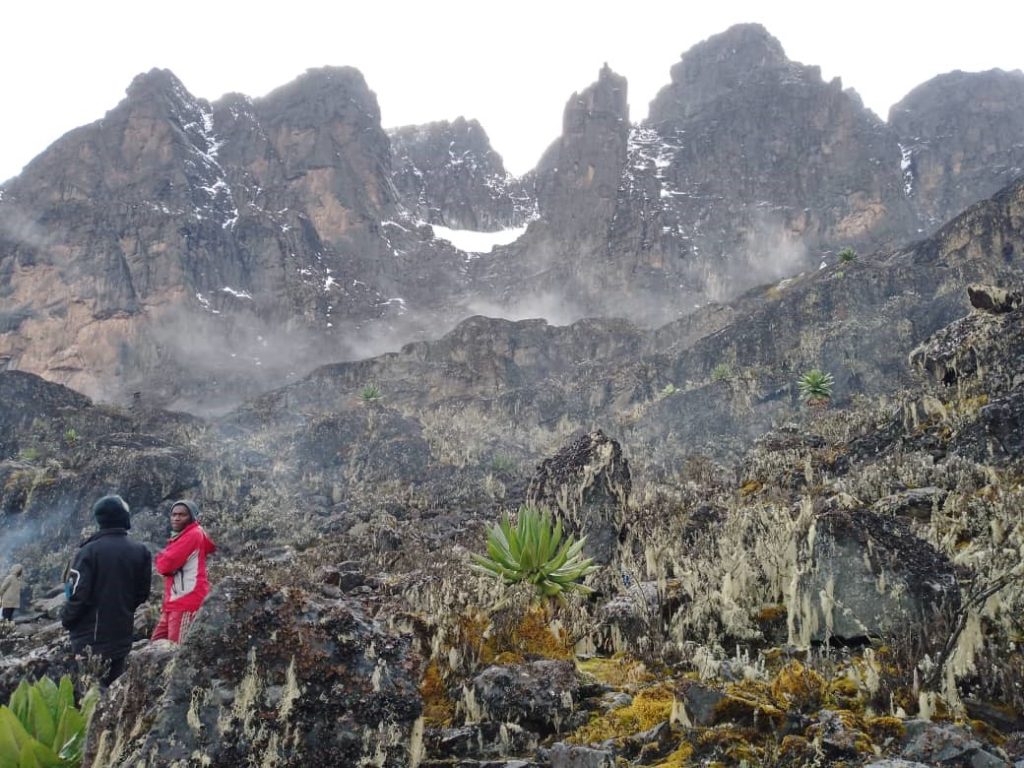
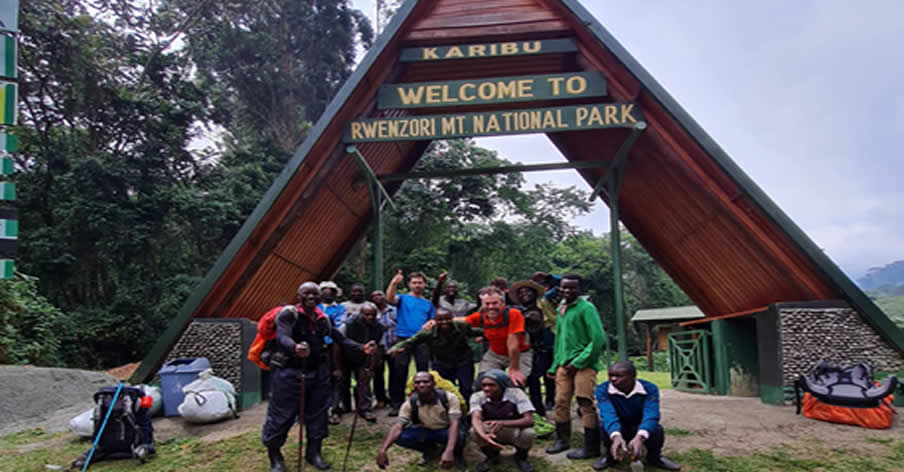
I have guided expeditions on the Rwenzori Mountains for years from the dense equatorial forest above Nyakalengija at 1,646 metres to the glaciated summit of Margherita Peak at 5,109 metres and I find, without exception, that even well-travelled, well-researched trekkers arrive on the mountain holding only a fraction of the facts that make it one of the most extraordinary places on Earth. This article corrects that. What follows are thirty facts about the Rwenzori Mountains geological, ecological, historical, glaciological, cultural, and geographical each of which, when properly understood, deepens the appreciation of what trekkers are walking into when they step off the path at the Nyakalengija trailhead and enter the forest.
These are not trivia items. They are the structural facts of a mountain range that deserves to be understood, not merely photographed. By the end of this guide, you will know the Rwenzori its age, its origins, its records, its losses, its secrets in a way that very few people on Earth do.
Geography, Geology, and the Physical Architecture of the Range
The Foundation of the Mountains of the Moon
Fact 1:
The Rwenzori Mountains are not volcanic. This is the fact that most immediately surprises people who know Africa’s great mountains primarily through Kilimanjaro (volcanic), Mount Kenya (volcanic), and the Virunga Range (active volcanic). The Rwenzori range is a horst, a block of ancient Precambrian crystalline rock, primarily gneiss and quartzite, that was forced upward along fault lines during the geological convulsions that created the Albertine Rift Valley approximately three to four million years ago. While the surrounding rift valley dropped, the Rwenzori block rose, pushed skyward by tectonic forces rather than built upward by volcanic activity. This makes the Rwenzori one of the oldest exposed rock surfaces in East Africa, with basement rocks dating to approximately two billion years ago.
Fact 2:
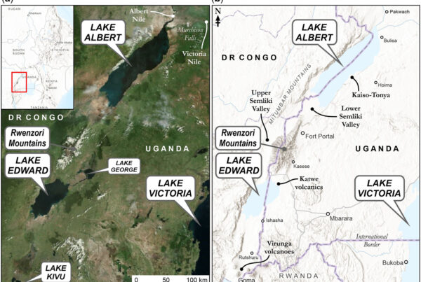
The Rwenzori range straddles the border between Uganda and the Democratic Republic of Congo, with the vast majority of the Ugandan side managed as Rwenzori Mountains National Park, a UNESCO World Heritage Site gazetted in 1994. The DRC side is managed as Virunga National Park, itself a UNESCO World Heritage Site and one of Africa’s oldest national parks. Together, the two protected areas create a transboundary conservation zone of extraordinary ecological significance. The mountain range extends approximately 120 kilometres from north to south and 65 kilometres from east to west at its widest point.
Fact 3:

The Rwenzori is home to six distinct massifs, each centered on one of the range’s major peaks. Mount Stanley, with its twin summits of Margherita (5,109 m) and Alexandra (5,091 m), is the highest. Mount Speke (4,890m), Mount Baker (4,843m), Mount Emin (4,798m), Mount Gessi (4,715m), and Mount Luigi di Savoia (4,627m) complete the set. All six massifs have summits above 4,600 metres, making the Rwenzori one of the most consistently high mountain ranges in Africa, a feature that directly shapes the extraordinary range of altitude-specific vegetation zones and makes every trekking day a journey through a different ecological world.
Fact 4:
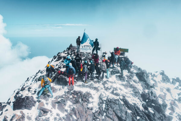
Margherita Peak, at 5,109 metres is the third highest point in Africa, behind Kilimanjaro (5,895 m) in Tanzania and Mount Kenya (5,199 m) in Kenya. This fact surprises people who expect that Africa’s highest points will be more widely celebrated. The relative obscurity of Margherita Peak compared to the global fame of Kilimanjaro is almost entirely a function of the mountain’s difficulty of access and the demanding conditions of the climb. The Margherita Peak summit expedition is a genuine technical mountaineering achievement involving glacier travel with crampons and ice axes, a very different proposition from the non-technical, walk-up summit of Kilimanjaro.
Fact 5:
The Rwenzori lies almost precisely on the equator; the range sits between approximately 0°05’N and 0°23’N latitude, with Margherita Peak positioned at roughly 0°22’N. This makes it one of only three mountain ranges in the world with permanent glaciers at or near the equator, alongside the Andes in Ecuador and Peru and the volcanic peaks of Mount Kenya. The geological accident of the equatorial location combined with the extraordinary height of the Rwenzori massifs creates the unique climatic conditions, persistent moisture combined with high altitude, that sustain the permanent ice and produce the mountain’s legendary vegetation.
The Glaciers: Africa’s Disappearing Equatorial Ice
What the Ice Tells Us
Fact 6:
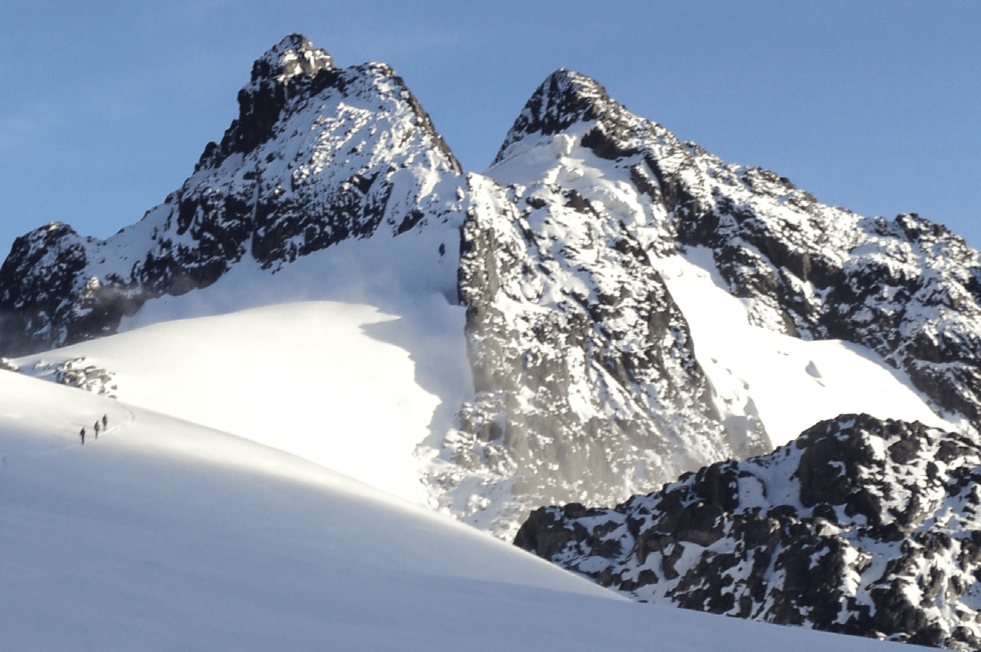
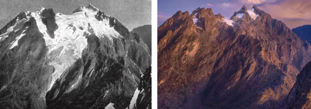
The Rwenzori Mountains contain the largest area of permanent glacial ice in Africa. This is a distinction they have held for as long as reliable records exist, and it is a distinction that is being eroded at a frightening speed. At the beginning of the twentieth century, when the first European explorers documented the Rwenzori’s glaciers systematically, the range contained approximately 6.5 square kilometers of glacial coverage across all six massifs. By 2023, that coverage had declined to less than 0.5 square kilometers, a reduction of more than 90% in roughly 120 years. Our guide to the disappearing Rwenzori glaciers covers the causes and trajectory of this loss in full detail.
Fact 7:
Glaciologists project that the Rwenzori’s remaining glaciers may disappear entirely within two to three decades, possibly by the mid-2030s under current warming trajectories or by the 2040s under more optimistic climate scenarios. This is not a distant or abstract projection: within the professional lifespan of the mountain guides currently working on the Rwenzori, the glaciers that define the character of the summit zone may cease to exist. Trekkers who summit Margherita Peak today are walking on ice that their children may not be able to walk on. This temporal urgency is one of the most compelling arguments for visiting the mountain now rather than waiting.
Fact 8:
The Rwenzori’s glaciers formed during the last major ice age approximately 10,000 to 20,000 years ago, when global temperatures were significantly lower and equatorial highlands maintained permanent ice at altitudes far below their current snow lines. As global temperatures warmed following the ice age, the Rwenzori’s glaciers retreated to their current high-altitude positions and have been retreating further with accelerating speed in response to anthropogenic climate change. The ice that remains today is a remnant of an ice system that once covered much of the upper Rwenzori range.
Fact 9:
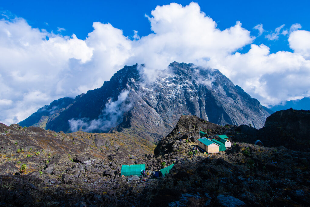
The named glaciers of the Rwenzori include the Elena Glacier, the Coronation Glacier, the Stanley Plateau, the Savoia Glacier, the Albert Glacier, the Margherita Glacier, and several smaller ice bodies. The Elena Glacier, which lies immediately above Elena Hut at 4,541 metres, is the glacier most directly encountered by trekkers on the Central Circuit Trail during the summit push. The Coronation Glacier is the primary crossing point on the route to Margherita Peak, the section of the climb that requires crampons and ice axes and that places the Margherita summit firmly in the category of technical mountaineering rather than high-altitude trekking.
Fact 10:
The Rwenzori glaciers are a critical source of water for the rivers and wetlands of the Albertine Rift Valley. Glacial meltwater makes up a large part of the Semliki River, which flows west from the Rwenzori into Lake Albert. As the glaciers diminish, the hydrological character of the rift valley rivers changes; seasonal flow becomes more variable, dry-season flows reduce, and the ecosystems and communities downstream that depend on consistent water supply face increasing uncertainty. The loss of the Rwenzori glaciers is therefore not merely an aesthetic or mountaineering concern; it is a regional ecological and hydrological event with consequences for millions of people and species.
Fact 11:
Despite their retreat, the Rwenzori glaciers are remarkable for their persistence. At the equator, permanent glaciers should not theoretically exist below approximately 5,500 metres given current global temperatures, yet the Rwenzori maintains ice at elevations as low as 4,400 metres. This persistence is a product of the mountain’s extraordinary precipitation; the wet air masses rising from the Congo Basin and Lake Victoria deposit enormous quantities of snow and ice on the upper mountain even as warmer temperatures erode the glacier margins. The Rwenzori’s weather system is simultaneously sustaining and destroying its ice: precipitation adds mass at the top while warming temperatures remove it at the edges.
Explorer History: The Mountains That Defied Discovery
How the World Came to Know the Mountains of the Moon
Fact 12:
The Rwenzori Mountains are almost certainly the “Mountains of the Moon” referenced by the ancient Greek geographer Claudius Ptolemy in his second-century CE work Geographia. Ptolemy described a range of mountains in the interior of Africa, from whose snows the Nile drew its source. This description, while attributed to the reports of merchants and travelers rather than personal observation, maps strikingly well onto the Rwenzori’s geographical position and hydrological function. The idea that Ptolemy’s ancient sources were describing the Rwenzori mountains that Europeans would not “discover” for another 1,700 years is a fact that situates the range at the very beginning of the European cartographic imagination of Africa.
Fact 13:
Henry Morton Stanley was the first European to see and document the Rwenzori Mountains with certainty in May 1888 during his Emin Pasha Relief Expedition. Stanley’s account of first seeing the snow-capped peaks through a gap in the clouds he initially disbelieved what he was looking at, having not expected permanent snow at the equator is one of the great moments in the literature of African exploration. Mount Stanley, the highest massif of the range, was named in his honor. Stanley called the range “Ruwenzori,” the anglicized spelling that would appear in most subsequent literature until the modern Ugandan standardization settled on “Rwenzori.”
Fact 14:
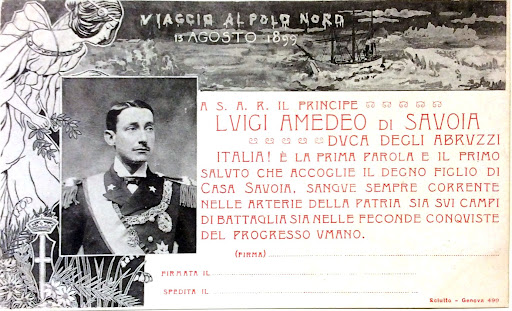
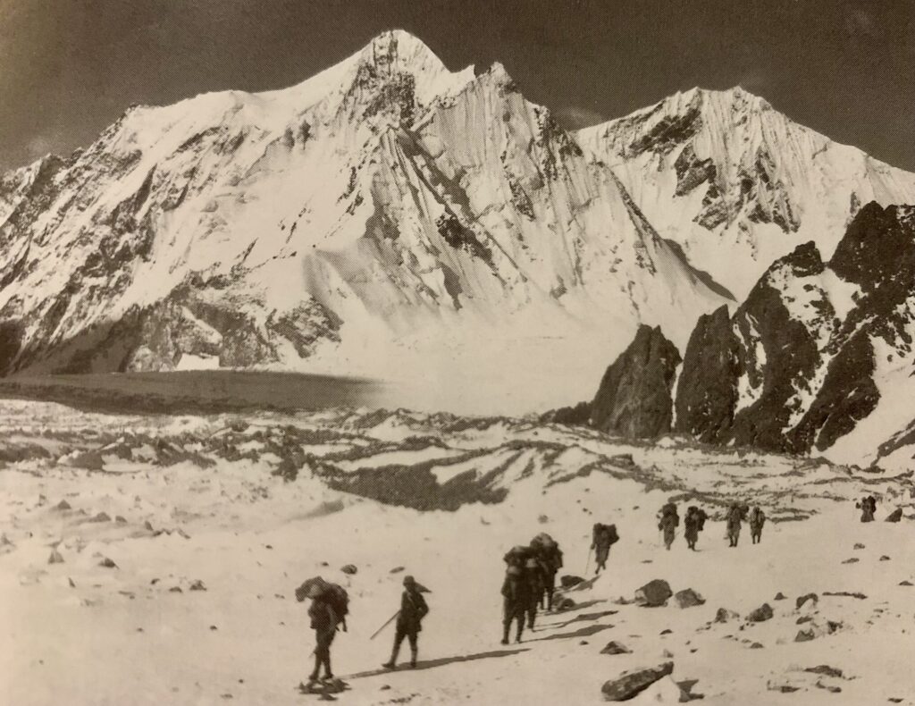
The Rwenzori’s most productive early exploration era was the Duke of Abruzzi’s 1906 expedition, which succeeded in making the first ascents of all the major peaks. Luigi Amedeo, Duke of the Abruzzi, an Italian prince with a distinguished record in both polar and Alpine exploration, led the expedition with a team of Italian mountaineers and local guides. The team made first ascents of Margherita Peak, Alexandra Peak, and the summits of Mount Speke, Mount Baker, Mount Emin, Mount Gessi, and Mount Luigi di Savoia, named for the Duke himself, in a single spectacular season. The Duke’s account of the expedition, Il Ruwenzori, published in 1909, remains one of the finest pieces of mountain exploration literature from the colonial era.
Fact 15:
Margherita Peak is named after Queen Margherita of Savoy, the Italian queen consort who was the patron of the Duke of Abruzzi’s 1906 expedition. The naming was a common practice of the era; geographic features in newly “discovered” territories were named for European royalty, patrons, and sponsors. Alexandra Peak (5,091m), the twin summit of Margherita on Mount Stanley, is named after Queen Alexandra of the United Kingdom. The two queens standing side by side on Africa’s highest massif represent a geographical fact with an inherent historical irony: these equatorial African mountains bear European names, in a range that the local Bakonzo people had known, named, and navigated for thousands of years before any European set eyes on them.
Fact 16:
The Bakonzo people of the Rwenzori foothills, who call themselves the Konzo and whose kingdom, Obusinga bwa Rwenzururu, is recognized by the Ugandan government, have lived in a relationship with the Rwenzori for millennia. Their name for the range, “Rwenzururu,” meaning “Place of Snow” in the Bakonzo language, predates all European naming by centuries. The Bakonzo community forms the backbone of the modern mountain guide and porter workforce, with the traditional knowledge of the mountain’s trails, water sources, and weather patterns passed across generations and now formalized into the professional mountain guiding industry. To trek the Rwenzori with a Bakonzo guide is to benefit from a depth of mountain knowledge that no amount of cartographic study or expedition literature can replicate.
Fact 17:
The Rwenzori was the last of Africa’s major mountain ranges to be systematically explored and mapped by European expeditions. While Kilimanjaro’s summit was first reached by Hans Meyer in 1889 and Mount Kenya’s by Halford Mackinder in 1899, the Rwenzori’s persistent cloud cover, complex terrain, and demanding approach conditions made systematic exploration more difficult. The mountain’s resistance to easy discovery is one of the reasons it has never achieved the popular fame of Kilimanjaro; it remains, in a sense, a mountain that requires genuine effort to understand, not merely to summit
Ecology and Biodiversity: A Living Museum of Evolution
The Life That Thrives Where No Life Should
Fact 18:
The Rwenzori Mountains are a recognized global biodiversity hotspot and are included within the broader Albertine Rift biodiversity hotspot, one of the most species-rich areas on Earth and the region with the highest density of endemic vertebrate species in Africa. The Albertine Rift hotspot contains more endemic species than any other region in mainland Africa, and the Rwenzori contributes disproportionately to that total, functioning as a biological island whose altitude and isolation have driven evolutionary processes that do not occur at lower elevations.
Fact 19:
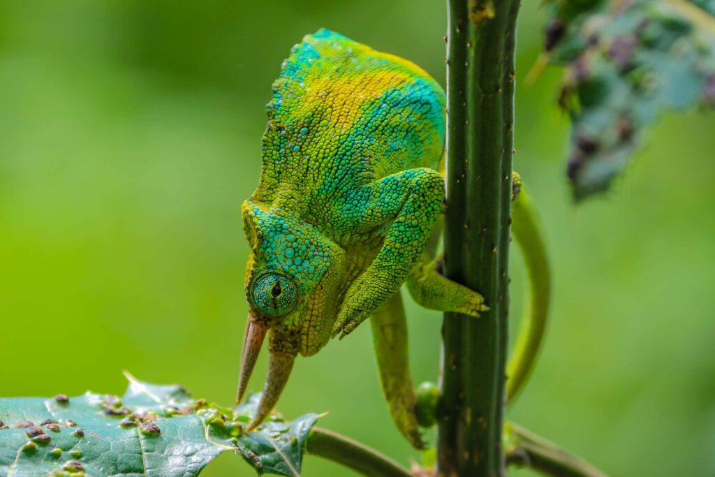
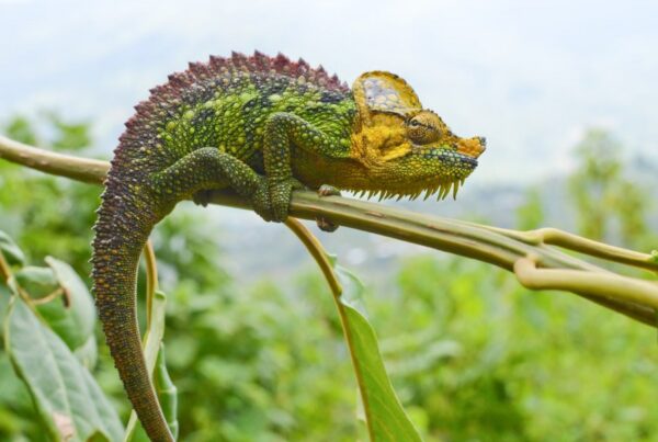
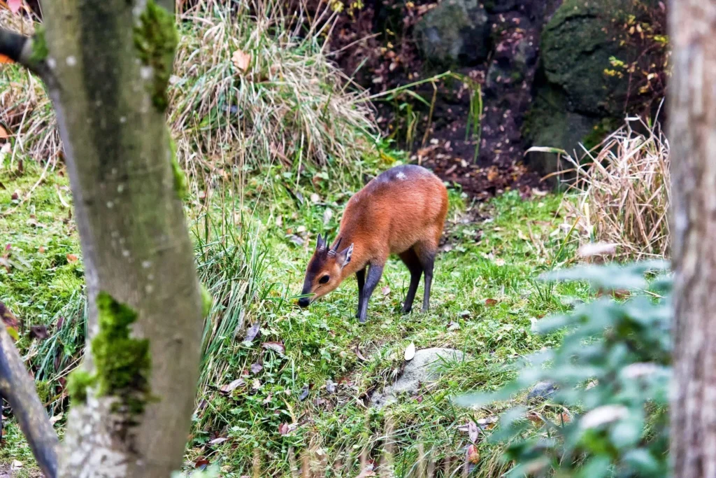
The Rwenzori is home to more than 70 mammal species, over 200 bird species (including 19 Albertine Rift endemics), and hundreds of plant species found nowhere else on Earth. Among the most notable wildlife residents are the Rwenzori leopard (one of the highest-altitude leopard populations in Africa), the three-horned chameleon (Trioceros johnstoni), the L’Hoest’s monkey, the black-and-white colobus, the giant forest hog, various species of otter, and the Rwenzori turaco (Ruwenzorornis johnstoni), one of the range’s most spectacular endemic birds. Our complete Rwenzori wildlife guide covers the full inventory of species, habitat zones, and best observation opportunities across the trail network.
Fact 20:
The Rwenzori’s most visually extraordinary ecological feature is its giant plant life of the upper alpine zone, a phenomenon known as “giant groundsel syndrome” or “high-altitude gigantism.” At elevations between 3,500 and 4,500 metres, plants that would be modest in size at lower altitudes grow to enormous dimensions: Senecio adnivalis groundsels reach four to six metres in height; giant heathers (Erica arborea) grow to tree size; giant lobelias (Lobelia wollastonii) rise two to three metres from the bog floor. This gigantism is driven by the unusual combination of intense daytime solar radiation and dramatically cold nights at high equatorial altitude, which creates growth conditions with no parallel anywhere in the world. The result is a landscape that has been described as “prehistoric,” “alien,” and “a world that evolution built separately”; all three descriptions are accurate.
Fact 21:
The Rwenzori contains five distinct vegetation zones stacked vertically from the valley floor to the permanent snowfields, a compression of biomes that would, on a temperate continent, span thousands of kilometers of latitude. The zones progress from montane forest (1,800–2,500 m) through bamboo (2,500–3,000 m) to heather moorland (3,000–3,500 m), then Afro-alpine (3,500–4,500 m), and finally nival/glacial zone (4,500 m and above). Passing through these zones in a single day of trekking is one of the most remarkable natural transitions available anywhere in world mountaineering. The full vegetation zone guide documents what each zone looks like, what species define it, and what the transition feels like underfoot and overhead.
Fact 22:
The Rwenzori’s bog zones, the saturated peatlands that fill the high valley floors, most notably the Bujuku Valley and the approaches to the Freshfield and Scott Elliot Passes, are ancient, deep, and ecologically critical. The peat that underlies these bogs has accumulated over thousands of years of plant growth and decomposition in conditions of permanent moisture and low bacterial activity. Some researchers estimate that some of the peat deposits in the Rwenzori’s upper valleys are more than 5,000 years old. These bogs function as carbon stores, water reservoirs, and unique habitat for specialist plant and invertebrate communities found nowhere else. The wooden bog bridges installed on the Central Circuit Trail protect both the trekker’s footing and the underlying peat structure from damage by repeated foot traffic.
Fact 23:
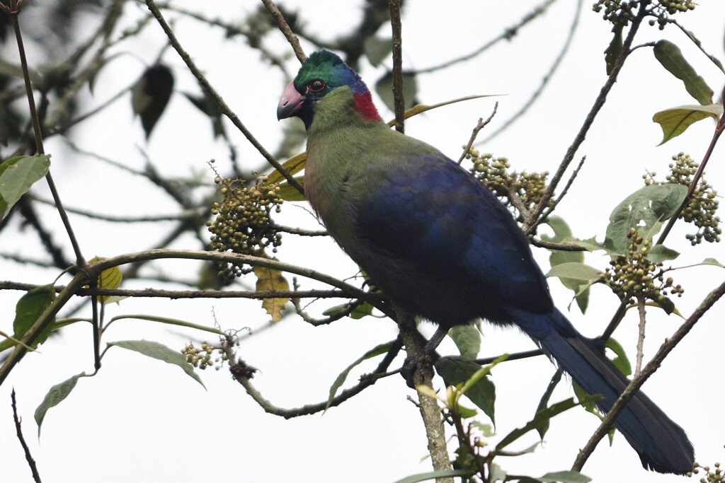
The Rwenzori turaco (Ruwenzorornis johnstoni) is one of the mountain’s most sought-after endemic species and one of the most visually spectacular birds in Africa. An adult Rwenzori turaco has deep blue-green plumage on the body, a distinctive crimson flight feather panel (the red of which is produced by a copper-containing pigment unique to turacos, turacin, that is water-soluble and was famously said by early naturalists to “run” in heavy rain), and a white-and-red facial pattern that makes identification unmistakable. It inhabits the montane forest zones of the lower Rwenzori and is most readily observed in the forest sections between Nyakalengija and Nyabitaba Hut. Trekkers who walk slowly and quietly through this section in early morning have the best chance of encountering it.
Fact 24:
The Rwenzori range is one of only three places in the world where you can observe active glaciers, giant groundsels, equatorial forest, and permanent snowfields within a single day’s walking distance of each other from the tropical forest at the trailhead through the Afro-alpine zone of giant plants to the glacier ice of the summit approach. This vertical compression of extreme habitats is unique to equatorial high-altitude mountains and reaches its most dramatic expression in the Rwenzori. The 13-day six-peaks expedition traverses the full ecological range from valley forest to multiple glaciated summits, providing an ecological transect that has no parallel on any other guided trekking route in Africa.
Records, Superlatives, and the Weather That Defines Everything
The Numbers and Superlatives That Explain the Mountain
Fact 25:
The Rwenzori Mountains receive between 1,800 and 3,000 millimeters of annual rainfall depending on altitude and aspect, making them one of the wettest mountain ranges in Africa and among the wettest mountain environments in the world. The moisture that produces this extraordinary precipitation comes primarily from two sources: the evapotranspiration of the Congo Basin rainforest to the west, which generates vast quantities of atmospheric moisture that is carried eastward by prevailing winds and forced upward by the Rwenzori’s mass; and the surface evaporation of Lake Victoria to the east, which contributes additional moisture to the east-approaching systems. The Rwenzori sits at the confluence of these two moisture systems and harvests both, which is why the mountain seems to generate its own weather, independent of what is happening in the surrounding lowlands.
Fact 26:
The Rwenzori Mountains were designated as a UNESCO World Heritage Site in 1994, recognized under criteria (vii), (x), and additional natural values specifically for the mountain’s outstanding natural beauty and the exceptional biodiversity and endemism of its ecological communities. The designation covers the Ugandan side of the range as Rwenzori Mountains National Park (99,600 hectares), while the Congolese side is protected under the Virunga National Park UNESCO designation. The 1994 designation was a formal international recognition of what the mountain’s ecology represents: an irreplaceable, globally significant natural system that has no equivalent.
Fact 27:
The Rwenzori Mountains host what may be the highest concentration of endemic Albertine Rift species of any single protected area in East Africa. The Albertine Rift itself, the western branch of the East African Rift System, stretching from Uganda’s Albertine graben through Rwanda, Burundi, and the eastern DRC, is home to more endemic vertebrate species than any other region on the African continent. Of the 38 bird species endemic to the Albertine Rift, 19 are found in the Rwenzori range. Of the 14 primate species endemic to the rift, several inhabit the Rwenzori’s forest zones. The mountain functions as a biodiversity archive of the western rift, a storage bank of evolutionary history that was protected by its altitude from the fluctuations of lowland ecology across ice ages and climatic cycles.
Fact 28:
Fewer than 2,000 trekkers complete multi-day expeditions in the Rwenzori Mountains each year, a figure that, set against Kilimanjaro’s approximately 50,000 annual climbers, illustrates the profound degree to which the Rwenzori remains a mountain for the genuinely committed rather than the merely ambitious. This low visitor number is not accidental: the mountain’s demanding conditions, the technical requirements of summit approaches, the absence of a simple walk-up route, and the genuine remoteness of the western Uganda location collectively select for trekkers and mountaineers who have done their research, prepared properly, and chosen the Rwenzori for what it actually is rather than for what they imagine a famous African mountain should be. The result is a mountain that rewards those who come to it with some of the most authentic wilderness experiences available in modern adventure travel.
Fact 29:
The local Bakonzo people have a portal legend concerning the Rwenzori that predates any European account of the mountain: the snow-capped peaks were believed to be the residence of the god Kithasamba, whose cold breath created the mists and whose anger manifested as storms. The mountain was approached with reverence and specific ritual observance by those who needed to venture into its upper zones: hunters following game upward, herders pushing livestock to high pasture. The tradition of deep respect for the Rwenzori’s upper zones as a spiritual place, a space between the human world and something beyond it, is one of the oldest continuously maintained cultural relationships with a mountain anywhere in Africa. It is worth carrying this knowledge into the forest when you begin your trek: you are walking into territory that has been considered sacred for far longer than it has been considered a trekking destination.
Fact 30:
The Rwenzori Mountains contain what is believed to be the highest altitude peat bog system in Africa, with peatland deposits in the upper Bujuku and Mubuku valleys that function at elevations between 3,500 and 4,000 metres above sea level. These high-altitude peat bogs are significant carbon sinks, holding organic carbon accumulated over millennia in conditions of permanently waterlogged, low-temperature anaerobic decomposition. The conservation of these peatlands within the national park boundary is, from a climate perspective, as significant as the conservation of tropical lowland peatlands, a fact that is rarely included in discussions of the Rwenzori’s environmental value but which underpins the mountain’s role as not merely a biodiversity asset but a climate regulation system.
Bonus fact:
The name “Rwenzori” is derived from the Bakonzo language and translates most directly as “Rainmaker” or “Place of Snow and Rain.” This name the mountain’s role in the local ecological and agricultural imagination, where the mountain’s waters feed the rivers, the rivers feed the fields, and the fields feed the communities. It is, in four syllables, both a geographical description and a statement of ecological relationship. The Rwenzori does not merely contain water; it makes the rain that sustains the region around it. This is a more honest and complete description of the mountain than any summit elevation or glacier statistic.
Why These Facts Matter When You Trek the Rwenzori
Every fact in this guide becomes a dimension of the experience once you are actually on the mountain. The giant groundsel you are walking past looks different when you understand that its size is due to the equatorial UV cycle. Understanding that the bog under your boots is 5,000-year-old peat changes how you walk on it. Knowing that the glacier you are crossing tomorrow has lost 90% of its volume in your grandparents’ lifetime changes how urgently you want to be standing on it. The Rwenzori is not simply a difficult hike with good views; it is a living geological, ecological, and cultural document that rewards the trekker who brings knowledge to the experience.
This is why we at Rwenzori Trekking Safaris invest in briefing our clients on the mountain’s context before they step onto the trail. The registration and departure briefing at Nyakalengija goes beyond logistics; it is the beginning of an interpretation of the mountain. Our guides are not simply route-finders; they are natural history interpreters with generational knowledge of the ecology, geology, and cultural landscape they are leading you through. The facts in this article are the framework; the guides and the mountain provide the experience that makes those facts vivid.
Whether you are drawn by the glaciers and the urgent, vanishing reality of equatorial ice; by the extraordinary ecology of the giant lobelia zone; by the technical mountaineering challenge of reaching Margherita Peak; by the historical resonance of following the Duke of Abruzzi’s 1906 first ascent routes; or simply by the profound and unusual experience of being on a mountain that almost nobody knows, the Rwenzori offers thirty reasons, and then some, to visit.
Frequently Asked Questions: Rwenzori Mountains Facts
What are the Rwenzori Mountains also known as?
The Rwenzori Mountains are also known as the Mountains of the Moon, a name derived from the ancient Greek geographer Claudius Ptolemy’s second-century CE geographical work, in which he described a range of high mountains in the interior of Africa from whose melting snows the Nile River drew its source. Researchers now believe that Ptolemy’s “Mountains of the Moon” were based on second-hand reports from traders and explorers who encountered the Rwenzori. The modern name “Rwenzori” derives from the Bakonzo language spoken by the indigenous people of the mountain’s foothills and translates most directly as “Rainmaker” or “Place of Snow and Rain.”
How high is the Rwenzori Mountains’ highest peak?
The highest peak in the Rwenzori Mountains is Margherita Peak, which stands at 5,109 metres (16,762 feet) above sea level. Margherita Peak is the summit of Mount Stanley, the highest of the six massifs that constitute the Rwenzori range. It is the third highest point in Africa, behind Kilimanjaro (5,895m) in Tanzania and Mount Kenya (5,199m) in Kenya. Margherita Peak was first climbed by the Duke of Abruzzi’s Italian expedition in 1906 and is named after Queen Margherita of Savoy. Unlike Kilimanjaro, the Margherita Peak summit involves glacier travel with crampons and ice axes, making it a genuine technical mountaineering achievement.
Are the Rwenzori Mountains volcanic?
No. The Rwenzori Mountains are not volcanic, a fact that distinguishes them from most of Africa’s other major mountain ranges. Unlike Kilimanjaro, Mount Kenya, and the Virunga volcanoes, the Rwenzori are a horst, a block of ancient Precambrian crystalline rock (primarily gneiss and quartzite) that was pushed upward along fault lines during the formation of the Albertine Rift Valley approximately three to four million years ago. The surrounding rift valley dropped as the Rwenzori block rose, producing a non-volcanic uplifted mountain range. The basement rocks of the Rwenzori date to approximately two billion years ago, making the range one of the oldest exposed rock surfaces in East Africa.
Is the Rwenzori a UNESCO World Heritage Site?
Yes. Rwenzori Mountains National Park was designated as a UNESCO World Heritage Site in 1994. The designation was granted under criteria recognizing the mountain’s outstanding natural beauty, its exceptional biodiversity, and the high degree of endemism in its ecological communities. The national park covers 99,600 hectares on the Ugandan side of the range. The Congolese side of the Rwenzori is protected under the Virunga National Park UNESCO designation. Together, the two designations create a transboundary conservation zone of global ecological significance.
Why are the Rwenzori glaciers disappearing?
The Rwenzori glaciers are disappearing primarily due to anthropogenic climate change, the progressive warming of global temperatures caused by greenhouse gas emissions from humans. At the beginning of the twentieth century, the Rwenzori range contained approximately 6.5 square kilometers of glacial coverage. By 2023, that coverage had declined to less than 0.5 square kilometers, a reduction of more than 90% in approximately 120 years. At current warming trajectories, glaciologists project that the remaining Rwenzori glaciers may disappear entirely within two to three decades, possibly by the mid-2030s to 2040s. The Rwenzori’s equatorial location makes its glaciers particularly sensitive to temperature increases, as there is no seasonal cooling to moderate warming trends the way that seasonal variation provides some mitigation in higher-latitude mountain ranges.
What is unique about the vegetation on the Rwenzori Mountains?
The Rwenzori’s most distinctive ecological feature is the phenomenon of high-altitude gigantism in its upper alpine zone, where plants that are modest-sized at lower elevations grow to extraordinary dimensions. Giant groundsels (Senecio adnivalis) reach four to six metres in height; giant lobelias (Lobelia wollastonii) rise two to three metres from the bog floor; giant heathers grow to tree size. This gigantism is driven by the unusual combination of intense daytime solar radiation and dramatically cold nights at high equatorial altitudes, a combination of UV intensity and temperature extremes that has no parallel at any other mountain location in the world. The Rwenzori also contains five distinct vegetation zones stacked vertically between the valley floor and the permanent snowfields, creating a compression of biomes in a single day of altitude gain that would span thousands of kilometers on a temperate continent.
How many trekkers visit the Rwenzori Mountains each year?
Fewer than 2,000 trekkers complete multi-day expeditions in the Rwenzori Mountains each year. This is a remarkably low figure when set against Kilimanjaro’s approximately 50,000 annual climbers or Mount Kenya’s 15,000 to 20,000. The low visitor number reflects the mountain’s demanding conditions, the technical requirements of summit approaches to Margherita Peak, the absence of a non-technical walk-up summit route, the remoteness of western Uganda as a destination, and the overall difficulty of the Rwenzori compared to the popular East African mountain alternatives. The result is one of the most genuinely uncrowded mountain experiences available to international trekkers, a wilderness quality that the Rwenzori’s high-visitor-number counterparts cannot match.
What was the Duke of Abruzzi’s role in Rwenzori history?
Luigi Amedeo, Duke of the Abruzzi, led the most historically significant mountain expedition in Rwenzori history when he brought an Italian team to the range in 1906. The expedition achieved first ascents of all major Rwenzori peaks in a single season: Margherita Peak (5,109 m), Alexandra Peak (5,091 m), the summit of Mount Speke (4,890 m), Mount Baker (4,843 m), Mount Emin (4,798 m), Mount Gessi (4,715 m), and Mount Luigi di Savoia (4,627 m), named in the Duke’s own honor. The expedition was accompanied by the photographer Vittorio Sella, whose images of the Rwenzori remain among the most important documentary records of the mountain’s late-nineteenth-century glacier extent. The Duke subsequently published an expedition account, Il Ruwenzori (1909), which remains one of the finest pieces of mountain exploration literature from the colonial era.
What does the name Rwenzori mean?
The name “Rwenzori” derives from the Bakonzo language spoken by the indigenous Bakonzo people of the mountain’s foothills in western Uganda. The most direct translation is “Rainmaker” or “Place of Snow and Rain” a name that reflects the mountain’s ecological role as the primary water source for the rivers and agricultural communities of the surrounding region. The Bakonzo’s own name for the range, “Rwenzururu” (meaning “Place of Snow”), predates all European naming of the mountains by centuries. The indigenous name captures something that colonial cartographic practice tended to miss: the mountain’s relationship to the communities who lived in its shadow, for whom it was not a geographical curiosity or a mountaineering objective but a sacred, living presence that generated the rain, the rivers, and the conditions of life.
The mountain is waiting, and so are we.
Thirty facts. Two billion years of geological history. Fifteen thousand years of retreating glaciers. Generations of Bakonzo knowledge. Two centuries of European discovery. A UNESCO designation. It is a biodiversity archive without equal in Africa. At the summit, 5,109 metres above sea level and at the equator, one of the most extraordinary views is available to anyone anywhere on Earth, even from the ice that may not exist in a generation.

The Rwenzori Mountains are, in every factual dimension, one of the great mountains of the world. That they remain relatively unknown is not a secret to be protected; it is an invitation. An invitation to come before the crowds that will eventually discover them. An invitation to walk on the glaciers while they still exist. An invitation to stand among the giant lobelias at dawn with no other group in sight, in a landscape that evolution spent millions of years building specifically for you to be astonished.
Whether your Rwenzori expedition begins with a 3-day Mahoma Loop forest walk, a 7-day Margherita Peak summit trek, or the full commitment of the 13-day six-peaks grand expedition across all the massifs named for Italian royalty and African gods, the team at Rwenzori Trekking Safaris is ready to put you on the mountain with the preparation, the guidance, and the deep contextual knowledge that turns thirty facts into a lived experience.
Browse our full range of Rwenzori trekking itineraries, read our seasonal guide to the best months to trek, explore the detailed campsite conditions on every trail, or read what our clients say about the expeditions we have guided. And when you are ready to move from thirty facts to one extraordinary experience, contact our expedition team directly; we will help you plan the Rwenzori adventure you have been building toward since you first heard the name Mountains of the Moon.