Climb Vittorio Emanuele Peak (4,890 m), Africa’s 4th highest, in 5 days. Central Circuit Trail, Bujuku Camp, technical summit. Expert Rwenzori guides.
5-Day Mount Speke Trek | Climb Vittorio Emanuele Peak
5-Day Mount Speke Trek in the Rwenzori Mountains | Climb Vittorio Emanuele Peak, Uganda
The ultimate goal of the 5-day trek, unlike any other, is to hike Mount Speke, one of Uganda’s most magnificent and lonely mountains in the Rwenzori Mountains. This breathtaking alpine trekking experience in Africa’s “Mountains of the Moon,” a UNESCO World Heritage Site, is unlike any other.
Every day brings fresh sights to view and problems to overcome. The terrain includes boggy valleys abounding with giant lobelias, deep jungle trails, and bamboo woods. Mount Speke, at 4,890 m, offers stunning views of Lake Bujuku, Mount Stanley, and the Rwenzori Range. That’s the ideal way to end an intriguing hike. Only the most adventurous and expert hikers should try this obscure trek. Expect it to challenge your limits and inspire awe.
There are mountains you visit and mountains that permanently alter your understanding of what a mountain can be. Mount Speke, the second-highest peak in the Rwenzori Mountains and Africa’s fourth-highest summit, belongs firmly in the second category. At 4,890 m, its Vittorio Emanuele Peak towers above Lake Bujuku in a landscape so otherworldly and so remote that it receives only a handful of trekking teams each year. That is precisely what makes this expedition one of the most coveted and least-known alpine objectives in equatorial Africa.
The 5-Day Mount Speke Trek takes you through every ecological zone the Rwenzori has to offer: ancient equatorial forest, bamboo corridors, the notorious Bigo Bog with its giant lobelias rising like prehistoric sentinels, the moss-draped heather zone, the surreal Afroalpine world of giant groundsels and senecio trees, and finally the technical upper mountain where ropes, ice axes, and a harness separate this summit from any ordinary high-altitude trek. Five days. Four nights. A summit that demands everything you have.

About Mount Speke: Africa’s Fourth-Highest Summit
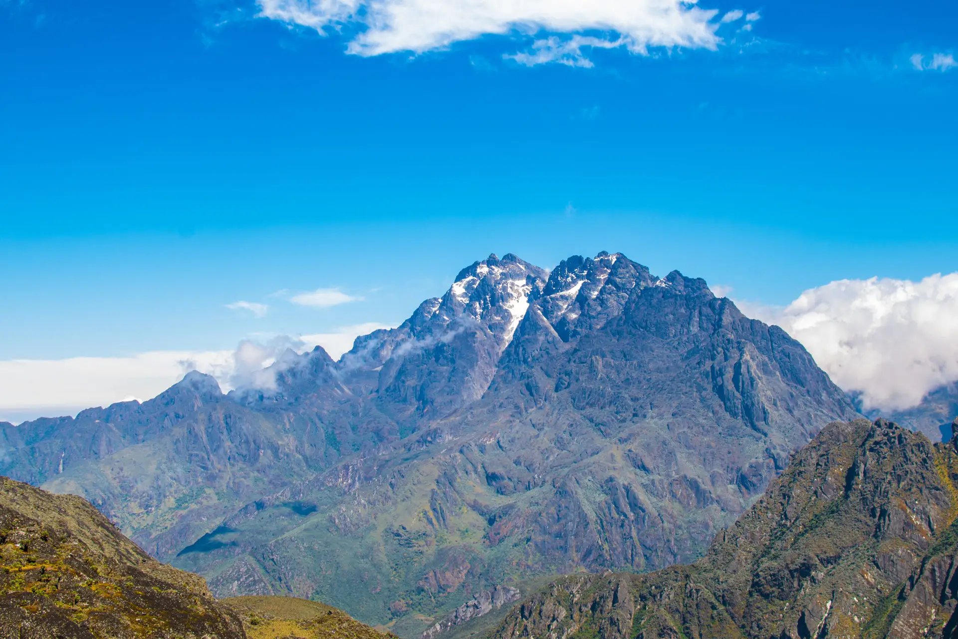
Mount Speke is the second-highest massif in Rwenzori Mountains National Park, surpassed only by Mount Stanley (Margherita Peak, 5,109 m). It is a multi-summited massif with four distinct high points, the highest being Vittorio Emanuele Peak at 4,890 m / 16,040 ft, named in honor of the Italian king by the Duke of Abruzzi’s 1906 expedition, which made the first recorded ascent of the Rwenzori’s major summits.
| Summit | Elevation | Notes |
| Vittorio Emanuele | 4,890 m / 16,040 ft | The highest point on Mount Speke summit of this trek |
| Ensonga | 4,865 m / 15,961 ft | The second highest Speke summit |
| Johnston | 4,834 m / 15,860 ft | Third summit ridge |
| Trident | 4,572 m / 15,000 ft | Lower western summit |
Mount Speke sits on the eastern side of the Bujuku Valley, directly facing Mount Baker (4,843 m) across the valley and overlooked by the imposing west face of Mount Stanley. The glaciers that once wrapped its upper ridges have retreated dramatically; over 80% of Rwenzori glacier mass has been lost in the last century, but remnant ice and snowfields still make the summit approach a genuine technical proposition. For the full context, please refer to our Glacier Retreat & Climate Change report.
Trek at a Glance: 5-Day Mount Speke Expedition
| Duration | 5 Days / 4 Nights |
| Total Distance | ~51.5 km (Day 1: 10 km, Day 2: 11 km · Day 3: 5.5 km · Day 4: 10–12 km · Day 5: 15 km |
| Summit / Max Elevation | 4,890 m Vittorio Emanuele Peak, Mount Speke (Africa’s 4th highest summit) |
| Trek Route / Trail | Central Circuit Trail Nyakalengija Trailhead |
| Key Camps | Nyabitaba (2,651 m) · John Matte (3,380 m) · Bujuku (3,962 m) |
| Difficulty | A strenuous/technically demanding summit day requires ropes, ice axe & harness |
| Best Season | December–February & June–August |
| Group Size | 1–8 trekkers (private departures available) |
| Technical Gear | Ropes, ice axes, helmets, harnesses provided |
| Accommodation | Wooden mountain huts on the Central Circuit |
| Start / End Point | Nyakalengija village, ~22 km from Kasese town |
| Price Indicator | From $1,200 per person |
Why the 5-Day Mount Speke Trek? What Makes This Expedition Unique.
The Rwenzori Mountains receive far fewer annual visitors than Kilimanjaro or Mount Kenya, and of those who do trek the range, the majority target Margherita Peak via the 7-Day Central Circuit. By contrast, a small fraction of Rwenzori visitors climb Mount Speke each year. That rarity is the first thing that distinguishes this expedition: you are attempting a genuine high-altitude summit that most East African trekkers have never heard of, on a route that gives you the mountain almost entirely to yourself.
The second distinction is ecological completeness. The Central Circuit Trail approach goes through all five of the Rwenzori’s major vegetation zones in 2.5 days of ascent, a biological journey that fits the equivalent of a continental altitude traverse into the space of a mountain valley. No other trekking itinerary in Uganda delivers this density of ecological transition. By the time you reach Bujuku Camp at 3,962 m, you have already passed through African equatorial forest, bamboo, tree heather, the Bigo Bog’s surreal giant lobelia fields, and the lower afro-alpine zone.
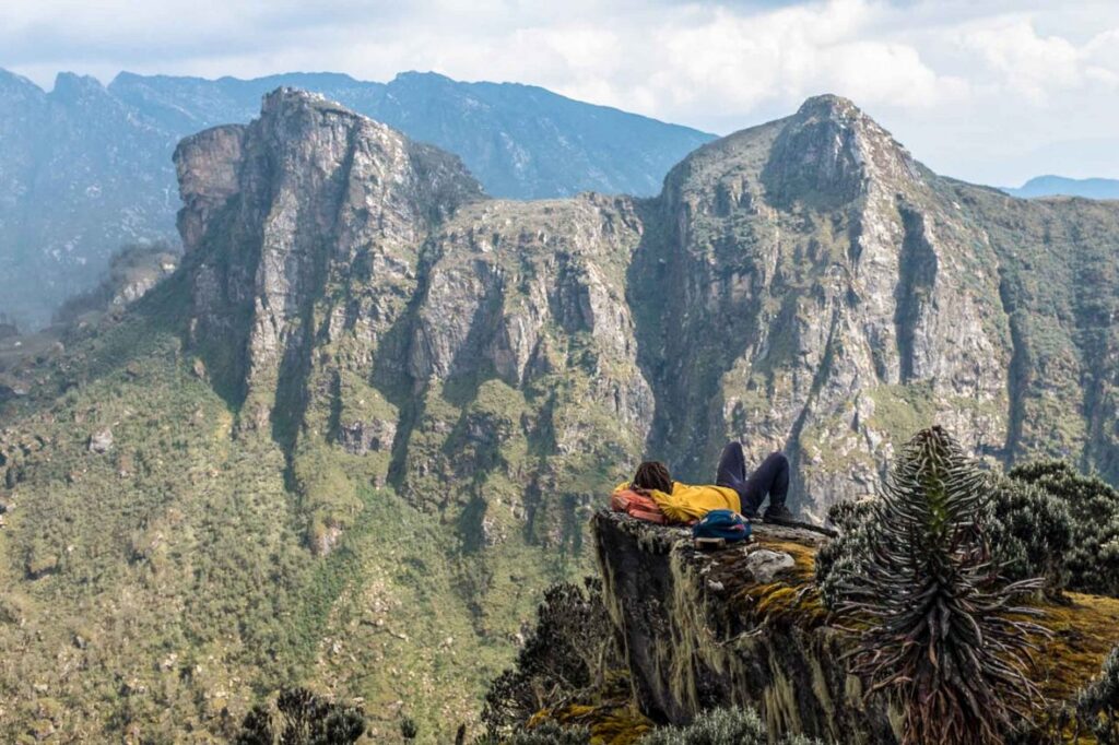
The third distinction is the summit itself. Vittorio Emanuele Peak is not a walk-up. The final approach from Bujuku via Groundsel Gully involves fixed ropes, a harness, and the kind of exposure that concentrates the mind entirely on the task at hand. The summit view of Mount Stanley and the Stanley Glacier to the west, Lake Bujuku far below to the east, and the DRC border foothills extending to the horizon is one of the finest panoramas in equatorial Africa. No photograph does it justice. That is the reward for the technical effort.
If you are considering both this trek and the 7-Day Margherita Peak climb, read our Central Circuit Trail comparison and route difficulty guide first. Both treks use the same approach; the 5-day Speke is more compressed and technically focused, while the 7-day offers broader acclimatization and the higher summit. Many serious trekkers choose to attempt Speke first, then return for Margherita.
Full Day-by-Day Itinerary: 5-Day Mount Speke Trek, Central Circuit
Day 1: Nyakalengija Trailhead (1,646 m) to Nyabitaba Hut (2,651 m)
Distance: ~10 km | Elevation Gain: ~1,005 m | Hiking Time: 5–6 hours | Terrain: Afro-Montane forest, river valley, steep ridge
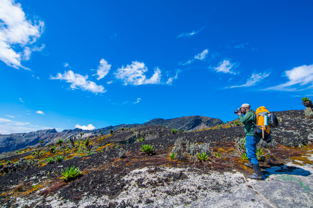
Your 5-day Mount Speke expedition begins at the Uganda Wildlife Authority ranger station and trailhead in Nyakalengija village, approximately 22 km from Kasese. A morning briefing with your guide team covers the route, safety protocols, emergency procedures, and technical gear that will come into play later in the trek. We check and stamp park entry permits here. Departure is by 9:00 AM at the latest. Day 1 is a full forest day.
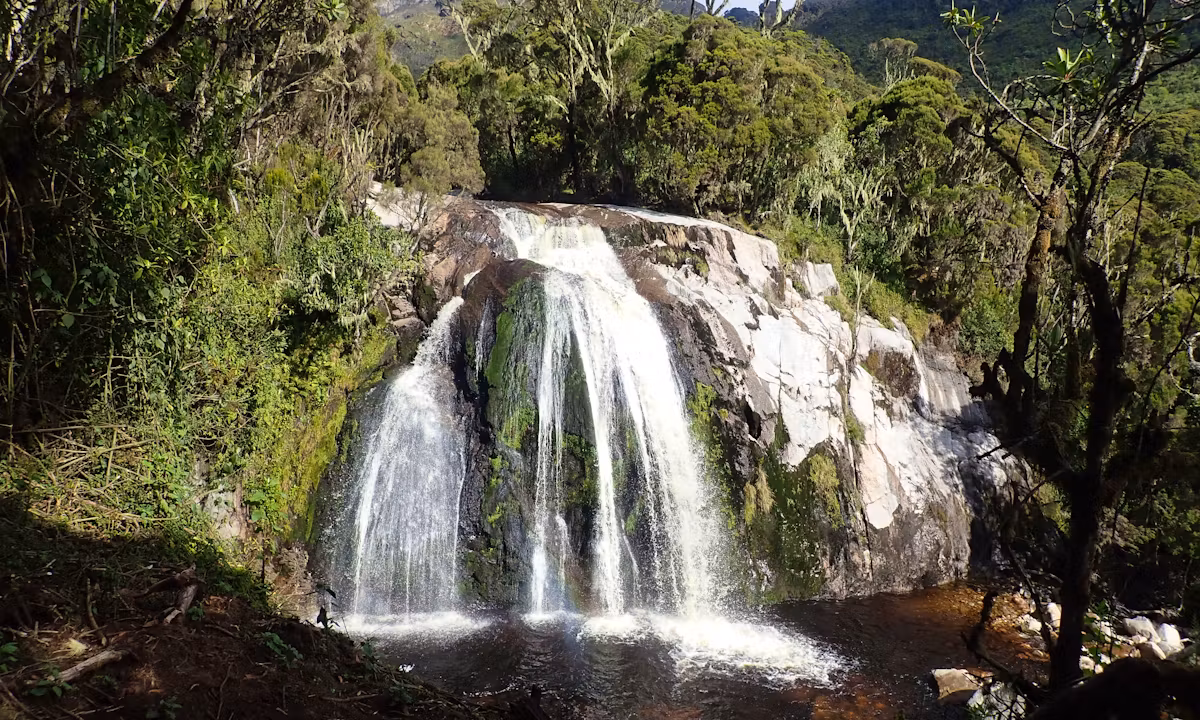
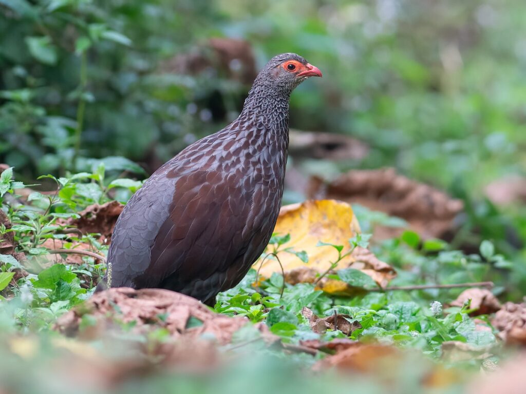
The trail drops almost immediately into the Mubuku River Valley, crossing a series of footbridges and entering the dense Afro-montane forest that characterizes the lower Central Circuit. This first section is gentler than the ascent later in the day, a 4 km warm-up walk that allows your legs and lungs to find their rhythm. The forest here is extraordinary: towering Podocarpus and Symphonia trees, every branch and trunk smothered in thick green moss and lichen, the canopy alive with the calls of Rwenzori turacos, African green broadbills, and handsome francolins below.
The trail crosses the Mubuku River on a wooden bridge, a classic Rwenzori moment, with the river tumbling fast and cold over dark volcanic rocks below before beginning the long climb up the Nyabitaba ridge. This ascent is the day’s major physical effort: a 600+ m climb through deepening moss forest, which is increasingly dense, increasingly wet, and increasingly quiet. The tree roots underfoot become the predominant trail surface, requiring constant foot attention.
Blue monkeys are regularly spotted in the canopy throughout this section, and the endemic three-horned Rwenzori chameleon (Trioceros johnstoni) is a common slow-moving presence on low branches near the trail. Your guide will point out medicinal plants used by the Bakonzo community; the lower forest on the Central Circuit has been used and understood by the indigenous mountain people for generations.
Nyabitaba Hut (2,651 m) is reached as the ridge levels out and the first views open on clear afternoons; the distant profile of Mount Stanley is visible to the north. The hut is a wooden mountain camp with bunk-style sleeping, blankets provided, and meals prepared by your guide team. The Porter’s Rest Bridge, a short walk below camp, offers a dramatic vantage point over the Mubuku Valley and is one of the better photography spots on the lower circuit. Dinner, a briefing for Day 2, and an early night tomorrow are all part of the real altitude that begins.
Key highlights: Mubuku River crossing · Afro-Montane forest immersion · Blue monkeys and Rwenzori turaco · Porter’s Rest Bridge viewpoint · First Central Circuit ridge views
Day 2: Nyabitaba Hut (2,651 m) to John Matte Hut (3,380 m)
Distance: ~11 km | Elevation Gain: ~729 m | Hiking Time: 6–7 hours | Terrain: Bamboo zone, heather zone, ridge traverse, river crossing
Day 2 is the longest day of the trek by distance, at 11 km, and the day on which the Rwenzori’s vegetative character begins to shift from forest to something altogether stranger. After breakfast at Nyabitaba, the trail continues north along the ridge before descending to cross the Bujuku River and beginning the long climb toward John Matte Hut.
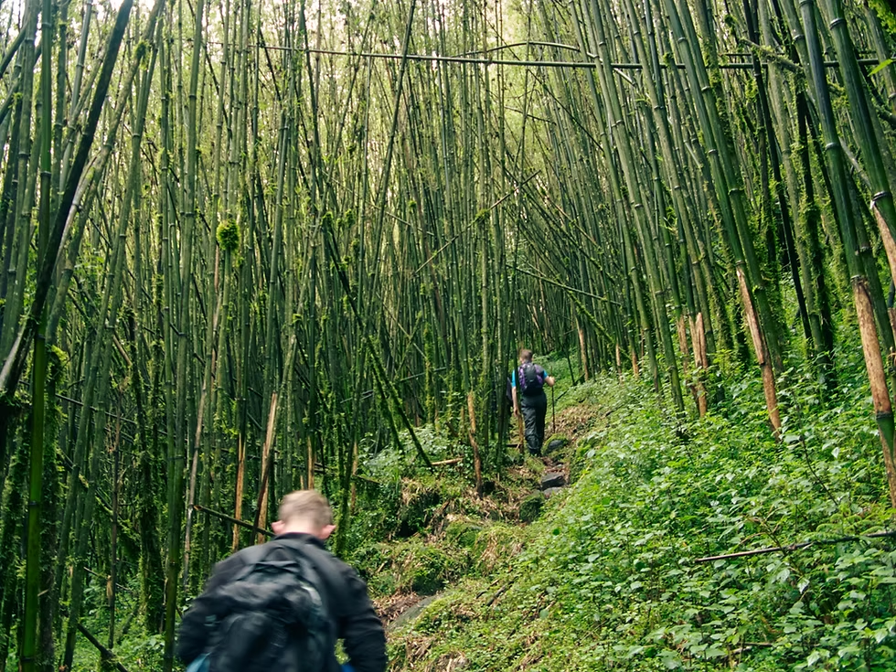
The bamboo zone begins at approximately 2,700 m on this section, with giant mountain bamboo (Arundinaria alpina) forming dense corridors that close overhead and mute sound in a way that is deeply atmospheric. The trail through the bamboo is often muddy underfoot, and the narrow path means single-file progress for most of the section. Rwenzori turacos are particularly active here; their distinctive calls announce their presence before the vivid crimson flash of their flight feathers confirms a sighting.
Above the bamboo, the heather zone opens up in stages, first as isolated patches of giant tree heather (Erica arborea) among the forest, then increasingly as the dominant vegetation until the forest retreats entirely and you discover yourself in a world of towering heather trunks draped in Sphagnum moss, old-man’s-beard lichen, and the occasional splash of Carduus afromontanus thistle. Panoramic views of Mount Stanley and the Margherita Peak face emerge on clear days from the open ridge sections; the first time you will see your surrounding giants properly.
John Matte Hut (3,380 m) sits in the heather zone on a broad open plateau, one of the most dramatically positioned camps on the entire Central Circuit. The hut overlooks the valley toward the east, and, on clear evenings, the light over the distant Ugandan lowlands creates an extraordinary sunset panorama. At 3,380 m, the altitude is now meaningful: some trekkers experience mild headaches or reduced appetite on their first evening here. This phenomenon is normal. Drink generously, eat well, and resist the urge to push on too fast. Your guide will monitor your condition.
Key highlights: Bujuku River crossing · Bamboo zone corridor · Rwenzori turaco sightings · Heather zone transition · Mount Stanley views · John Matte evening panorama
Day 3: John Matte Hut (3,380 m) to Bujuku Hut (3,962 m) via Bigo Bog
Distance: ~5.5 km | Elevation Gain: ~582 m | Hiking Time: 4–5 hours | Terrain: Bigo Bog, giant lobelia fields, alpine basin
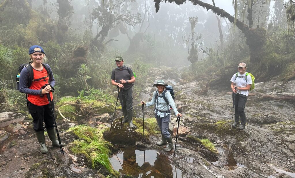
Day 3 is the shortest in distance but arguably the most visually dramatic of the entire 5-day trek. The trail from John Matte descends briefly to the valley floor before crossing the Bujuku River and entering the Lower Bigo Bog, the Rwenzori’s most famous and most surreal landscape feature.
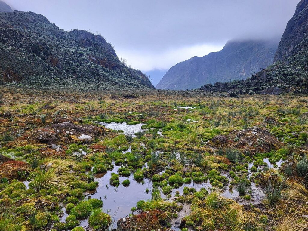
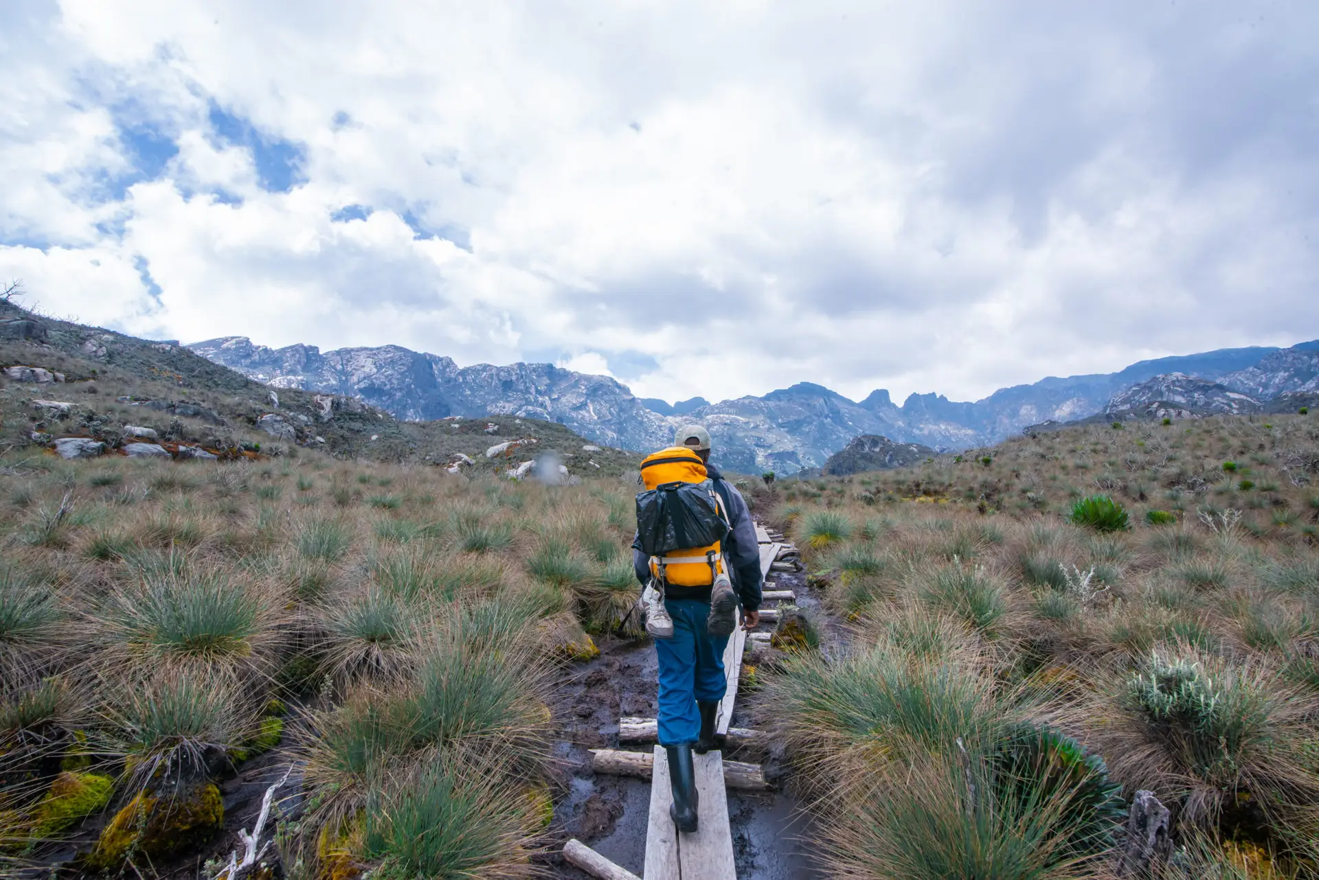
The Bigo Bog is a high-altitude wetland stretching across the valley floor at approximately 3,400–3,500 m. Crossing it requires careful footwork: the path is built on logs and board sections in some places, but in many others the bog simply has to be crossed through ankle-deep or knee-deep mud and standing water. Gumboots or high waterproof gaiters are essential. Your porters who cross this section in sandals with extraordinary skill and speed will make the crossing look effortless. It is not.
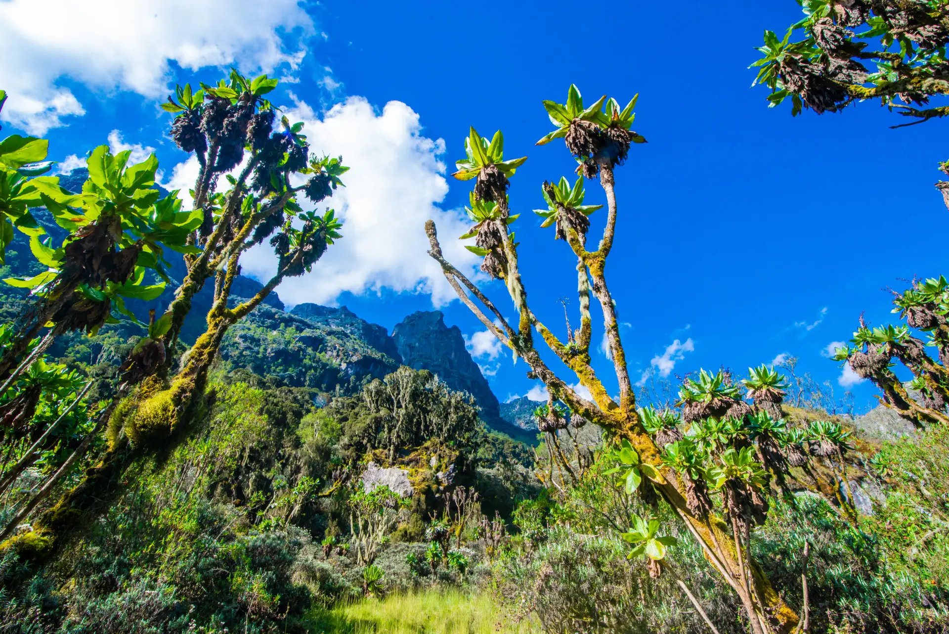
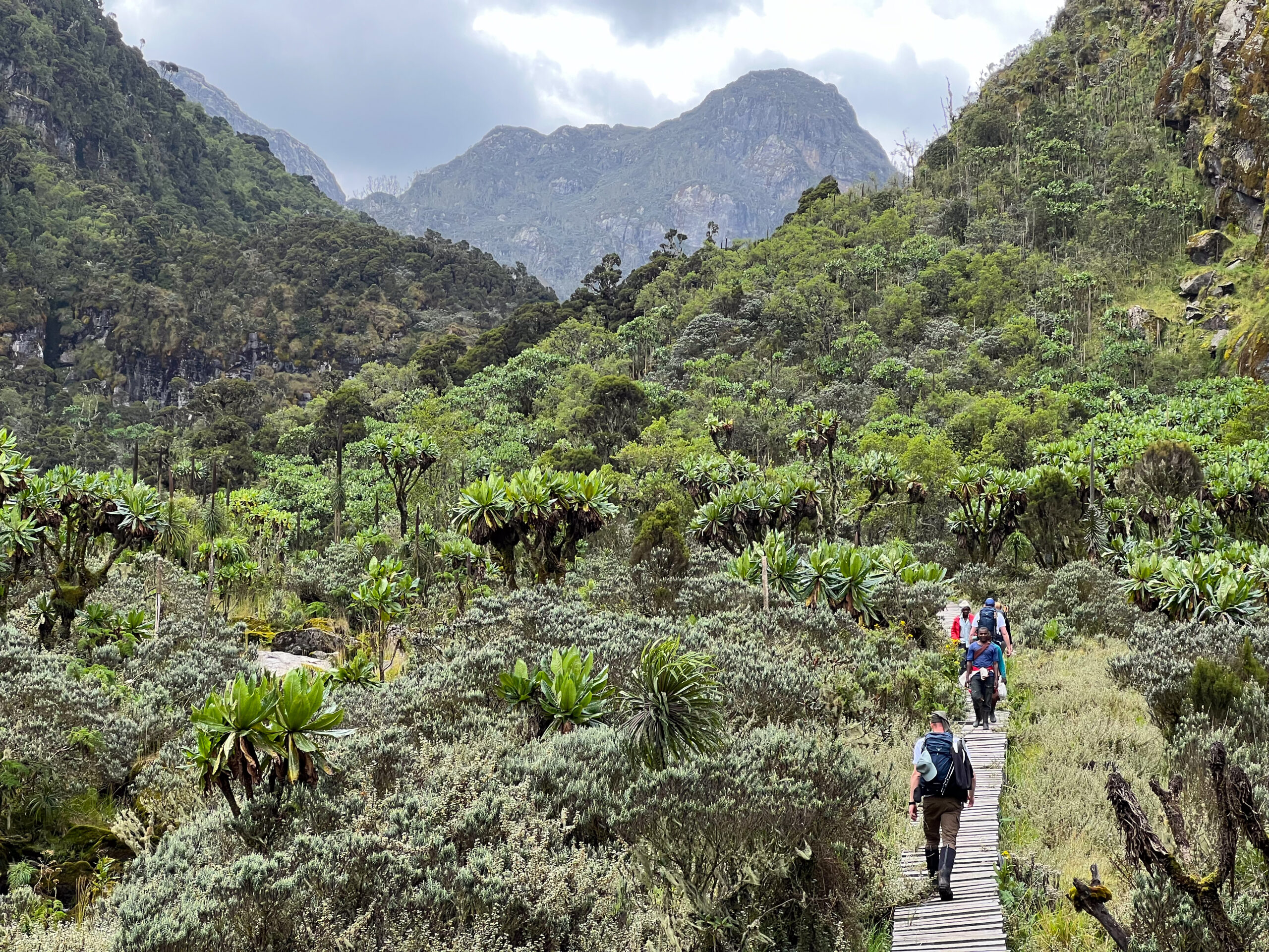
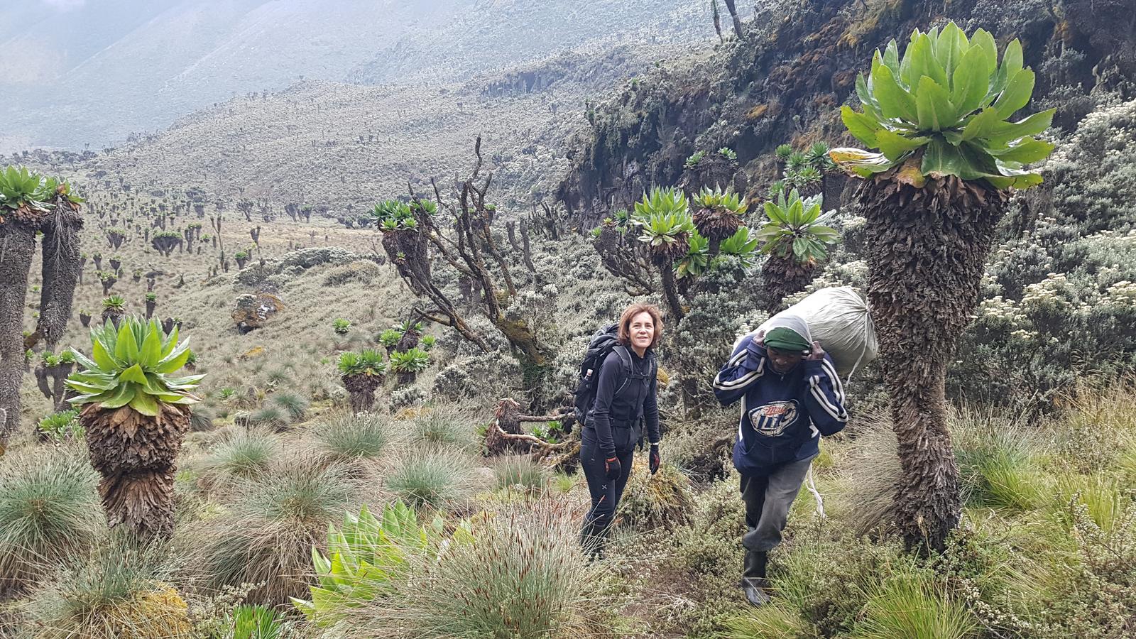
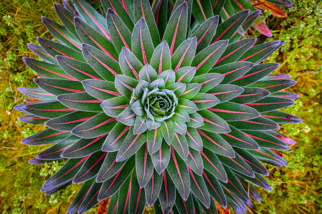
The bog is dominated by giant lobelias (Lobelia wollastonii), ancient plants with 2–3 m flower spikes that rise from dense rosettes of grey-green leaves, and their forms are unlike anything in a temperate mountain environment. These are not tall plants that happen to live at altitude; they are altitude plants, shaped by 4,000 years of equatorial mountain conditions into something that has no parallel on Earth at sea level. Alongside the lobelias, giant groundsels (Senecio adnivalis), the Rwenzori’s other iconic alpine plant, begin to appear as you climb, their succulent rosette stems rising on bare trunks in dense colonies across the upper valley.
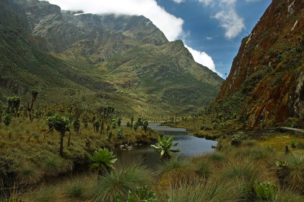
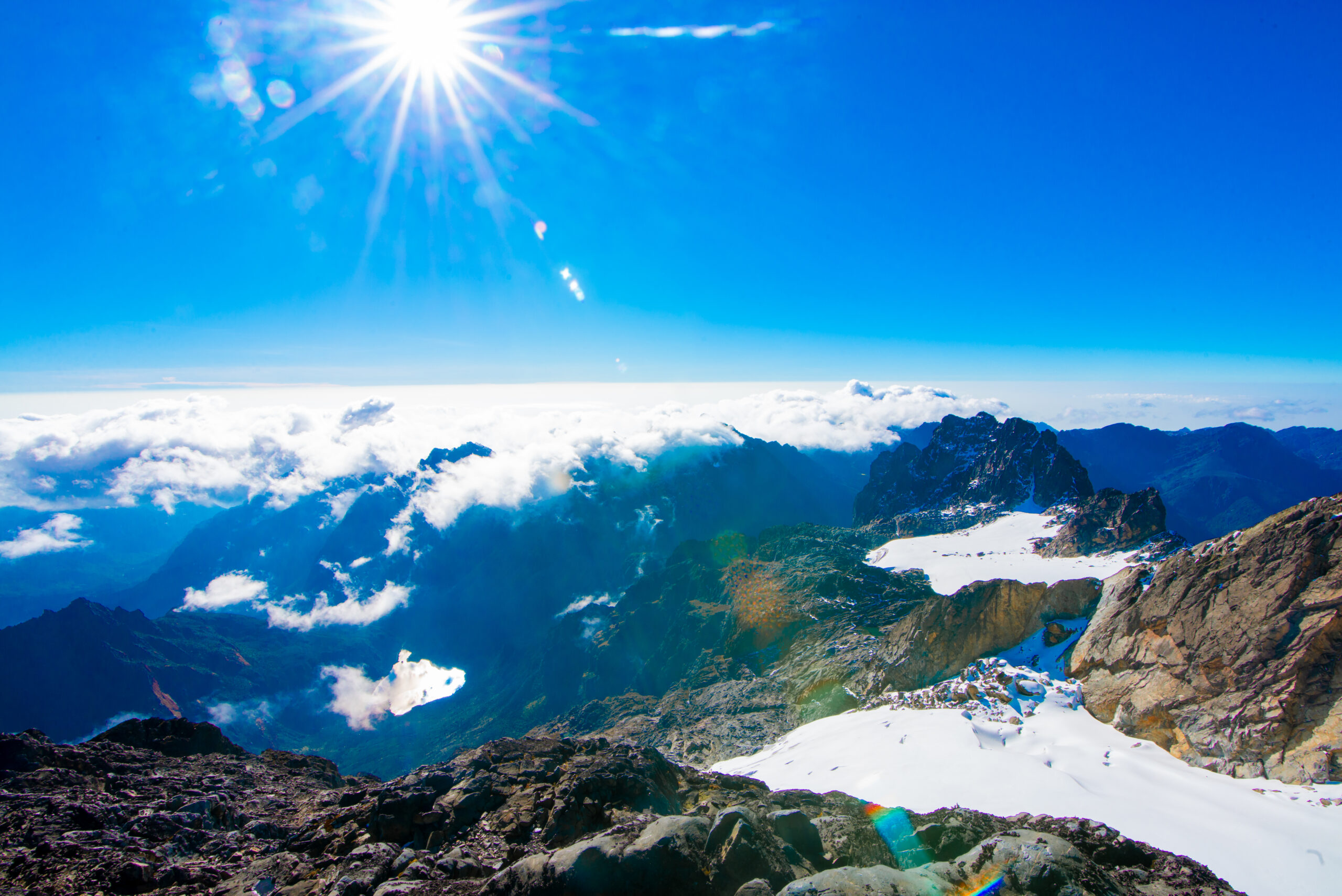
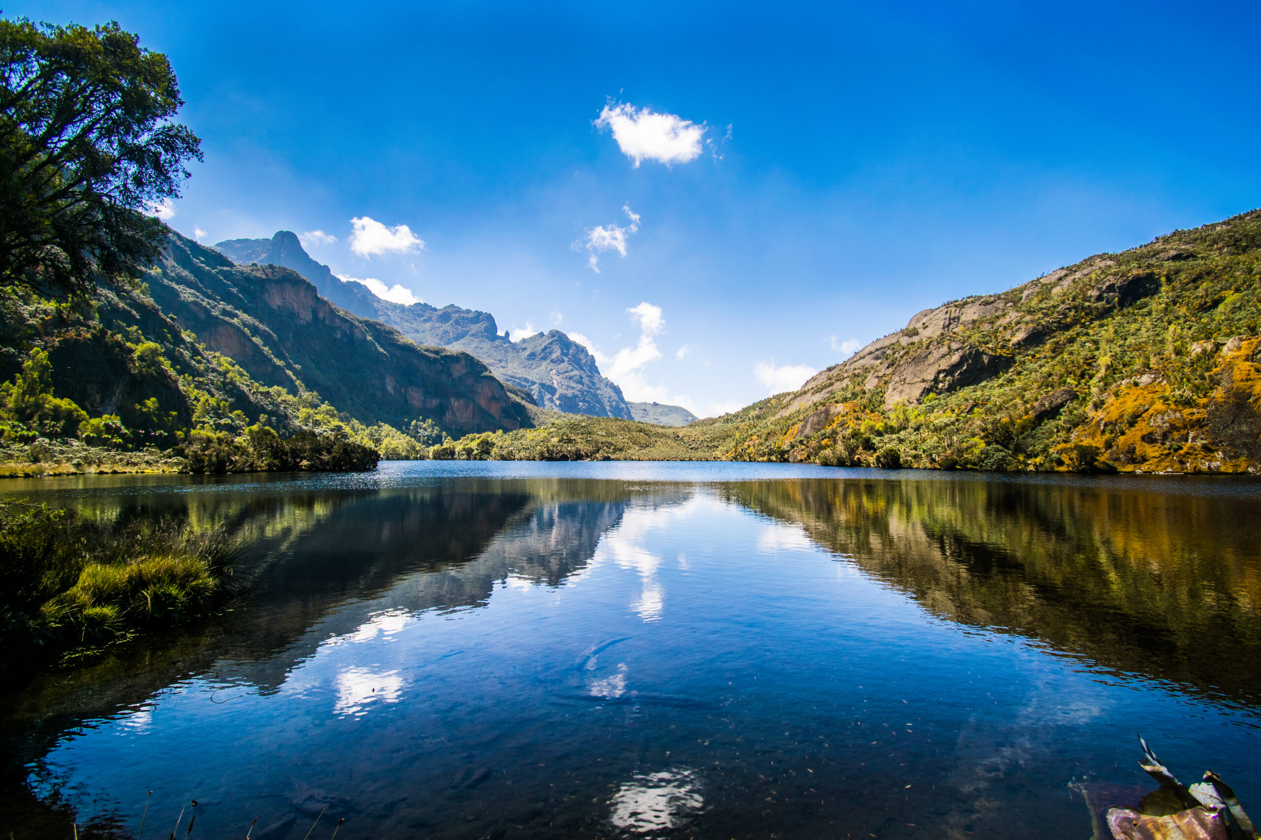
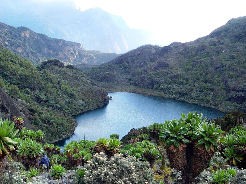
After the bog crossing, the trail climbs steadily to Lake Bujuku, a shallow, glassy alpine lake at approximately 3,900 m, set in a glacially carved basin with Mount Baker rising to the south and the walls of Mount Stanley looming to the west. This vista is one of the most photographed views in the entire Rwenzori range: the lake’s still surface reflecting the peaks above on clear days and the valley walls draped in giant senecios. Take your time here.
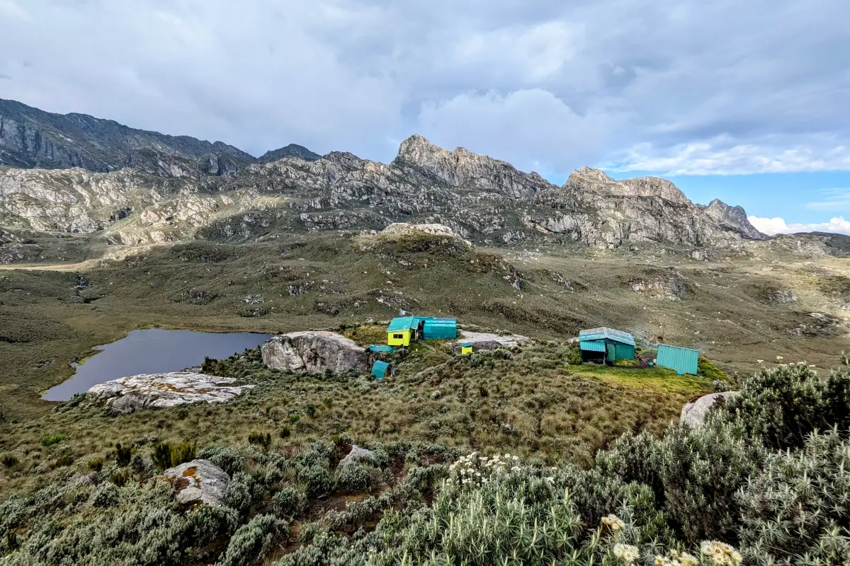
Bujuku Hut (3,962 m) sits just above the lake on a grassy rise. At this elevation, the air is noticeably thinner, and the nights are genuinely cold. Temperatures at Bujuku can approach -5°C or lower. Your guide team prepares a hot dinner and ensures you are equipped for the summit attempt tomorrow. The summit briefing happens here: the guide and trekker go over the technical equipment, the route through Groundsel Gully, the expected summit time, and the turnaround protocol. An early night is not negotiable; the summit day alarm is typically 3:00–4:00 AM.
Key highlights: Bigo Bog crossing · Giant lobelias and groundsels · Lake Bujuku panorama · Mount Baker and Stanley views from camp · Summit briefing at Bujuku Hut
Day 4: Bujuku Hut (3,962 m) → Summit Vittorio Emanuele Peak, Mount Speke (4,890 m) → Return to John Matte Hut (3,380 m)
Distance: ~10–12 km round trip to summit + 5.5 km descent to John Matte | Total hiking time: 9–11 hours | Terrain: Technical alpine Groundsel Gully, fixed ropes, summit ridge
The alarm sounds at 3:00–4:00 AM. A hot breakfast of tea, porridge, and eggs is served by headlamp in the Bujuku hut. Your guide does a final equipment check: harness fit, ice axe grip, headlamp batteries, and emergency whistle. By 4:00–5:00 AM, you leave Bujuku in darkness, headlamps illuminating the path above the lake. The air at 3,962 m before dawn is biting cold. This moment is the day that earns the expedition its name.
The summit approach climbs steeply from Bujuku, ascending the south-facing slope of Mount Speke through the Afroalpine zone. Giant groundsels (Senecio adnivalis) stand in silhouette against the pre-dawn sky as the trail gains elevation rapidly. The terrain underfoot transitions from mossy turf to rocky scree and, depending on seasonal conditions, to an ice-covered slope where crampons or careful axe technique become essential. Your guide moves ahead to set the pace; follow exactly, without shortcutting.
The approach enters Groundsel Gully, a steep, narrow couloir named for the giant groundsel plants that crowd its lower margins. This is where the fixed ropes begin. Your guide clips you in and walks you through the basic technique: Use three points of contact, the ice axe for balance, and steady upward movement, and do not look down for the first few rope lengths until you establish your rhythm. The gully is exposed, but the rock is generally solid. Move methodically and trust the system.
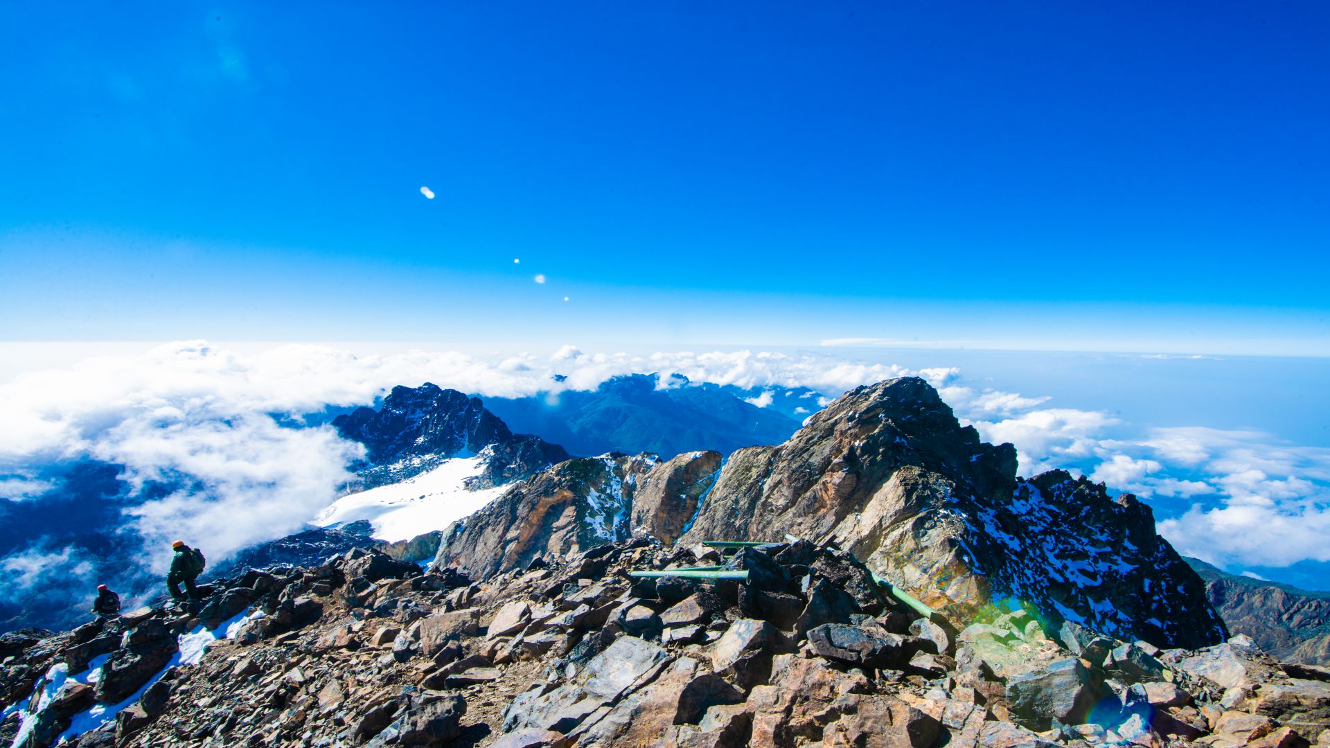
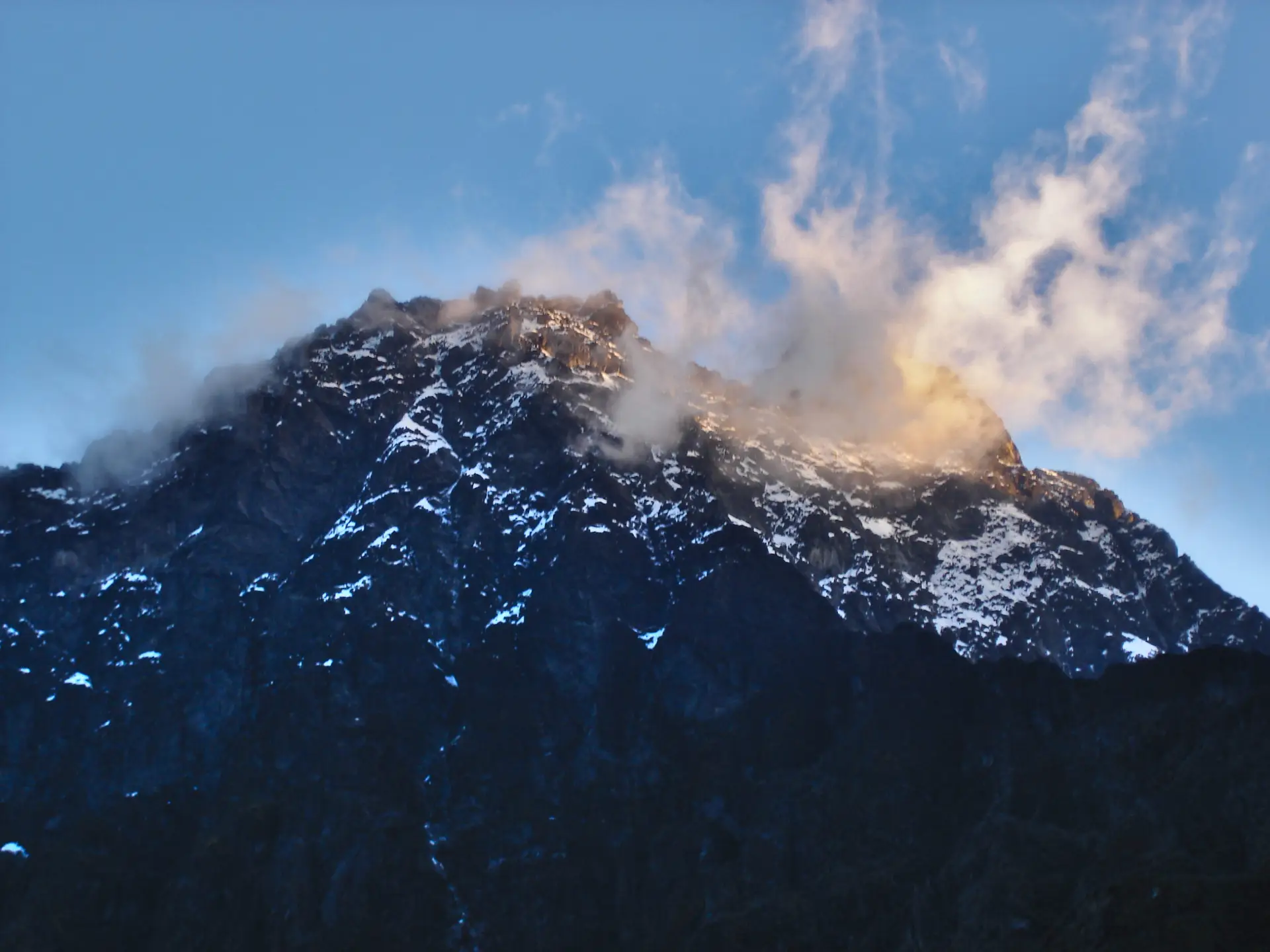
As the sky lightens behind you toward the east, the upper ridge of Vittorio Emanuele Peak comes into view above the gully exit. The final approach to the summit ridge is steep but manageable with rope support. And then the summit. Vittorio Emanuele Peak, 4,890 m, stands in the full light of an equatorial dawn. Mount Stanley fills the western sky with its walls and remnant glacier, while Lake Bujuku, a dark mirror 900 m below to the east, lies beneath it. To the south, the plains of Uganda stretch to the horizon, and the DRC border mountains fade northward. Most trekkers stand here in silence for several minutes. Some cry. All remember it for the rest of their lives.

Summit photos, a rest, and a hot drink from your guide’s flask. Then the controlled descent used fixed ropes in reverse to traverse the gully and return across the afro-alpine slopes to Bujuku. Here you collect your sleeping gear, congratulate the porter team, and begin the descent to John Matte Hut (3,380 m). The descent is 5.5 km over 3–4 hours, the altitude loss bringing warmth, oxygen, and a profound sense of earned satisfaction. Dinner at John Matte is the best-tasting meal of the trek.
Key highlights: Pre-dawn start by headlamp · Groundsel Gully fixed-rope section · Vittorio Emanuele Peak summit at 4,890 m · Lake Bujuku from the summit · Mount Stanley western panorama · Triumphant descent to John Matte
Day 5: John Matte Hut (3,380 m) → Nyabitaba Hut (2,651 m) → Nyakalengija (1,646 m)
Distance: ~15 km | Elevation Loss: ~1,734 m | Hiking Time: 6–7 hours | Terrain: Heather zone descent, bamboo, forest, river crossing
The final day is a long, sustained descent 15 km from John Matte to Nyakalengija, losing 1,734 m of elevation over 6–7 hours. After the physical and emotional peak of summit day, Day 5 carries a different energy: retrospective and quieter, the mountain releasing you slowly back toward the lowlands.
Departing John Matte after breakfast, the trail descends back through the heather zone in reverse. The descent through open heather is faster than the ascent but requires focused footwork. The trail is steep in places and can be slippery with morning dew or overnight rain. Trekking poles are especially valuable on this first descent section.
The re-entry into the bamboo zone brings warmth, humidity, and a welcome intensification of birdsong. The descending trekker moves faster through the bamboo than the ascending one, but the bamboo corridor on Day 5 tends to produce more wildlife sightings than any other moment on the trek. The morning feeding hours in the transitional zone between heather and bamboo attract the highest density of Rwenzori turaco, malachite sunbird, and Rwenzori double-collared sunbird activity. Pay attention on the way down.
Back at Nyabitaba Hut, we had a brief rest and packed lunch before the final descent to Nyakalengija. The lower forest section reintroduces the warm, humid air of the equatorial forest, blue monkeys in the canopy, the sound of the Mubuku River growing louder as the altitude drops, and the smell of the forest floor returning after four days above. The Mubuku River bridge crossing, so significant on Day 1, is a closing ceremony of sorts on Day 5.
The trek concludes at the Nyakalengija ranger station, where completion certificates are issued, summit records are logged by UWA, and the guide team is formally farewelled. Tips are distributed here; see the Tipping section below. Your transfer back to Kasese takes 30–40 minutes, where a warm shower and a well-earned dinner await. From Kasese, onward travel to Fort Portal, Kampala, or gorilla trekking in Bwindi is typically the next chapter.
Key highlights: Heather zone dawn descent · Bamboo zone birding · Nyabitaba lunch rest · Mubuku River bridge final crossing · UWA completion certificate · Porter and guide farewell at Nyakalengija
Elevation Profile: 5-Day Mount Speke Trek
Day 1: Nyakalengija (1,646 m) → Nyabitaba Hut (2,651 m): ~10 km, 1,005 m gain, 5–6 hours. A long valley approach and steep ridge climb through Afro-montane forests.
Day 2: Nyabitaba (2,651 m) → John Matte Hut (3,380 m): ~11 km, 729 m gain, 6–7 hours. The longest day by distance, passing through bamboo and into the heather zone.
Day 3: John Matte (3,380 m) → Bujuku Hut (3,962 m): ~5.5 km, 582 m gain, 4–5 hours. Short but transformative Bigo Bog, giant lobelias, Lake Bujuku.
Day 4: Bujuku (3,962 m) → Vittorio Emanuele Peak (4,890 m) → John Matte (3,380 m): ~10–12 km summit round trip + 5.5 km descent, 928 m gain to summit / 1,510 m total loss on return to John Matte. The expedition’s defining day.
Day 5: John Matte (3,380 m) → Nyabitaba (2,651 m) → Nyakalengija (1,646 m): ~15 km, 1,734 m descent, 6–7 hours. The long final descent through all the lower zones leads back to the trailhead.
Total distance: ~51.5 km | Max elevation: 4,890 m (Vittorio Emanuele Peak) | Total ascent: ~3,244 m | Total descent: ~3,244 m
Camps & Accommodation on the 5-Day Mount Speke Trek
Nyabitaba Hut, 2,651 m
Set on a broad forested ridge above the Mubuku Valley, Nyabitaba is the first overnight camp on the Central Circuit and the gateway to the mountain’s interior. The wooden mountain hut offers bunk-bed sleeping with mattresses and blankets provided. The Porter’s Rest Bridge, a five-minute walk from camp, offers sweeping views over the valley and is a classic photography spot. Temperatures at Nyabitaba: 10–15°C at night. The surrounding forest is alive with birds, and the distant sound of the Mubuku River below provides the evening’s ambient soundtrack.
Facilities: Wooden sleeping huts, pit latrines, outdoor kitchen. No electricity, limited phone signal. Water from mountain streams, treated by the guide team.
John Matte Hut, 3,380 m
John Matte sits on an open heather plateau at the transition between the bamboo and heather zones. The camp’s position gives it the best horizon views of any overnight stop on this itinerary, particularly toward Mount Stanley to the north and the Ugandan foothills to the east. Nights at John Matté are meaningfully cold (5–10°C), and a heavyweight sleeping bag becomes important here. This location is also the camp where altitude-related symptoms become more likely; a quiet evening, good hydration, and early sleep are the prescription.
Facilities: Wooden sleeping huts, pit latrines, and a camp kitchen. No electricity. No reliable phone signal. Water from mountain streams, treated by the guide team.
Bujuku Hut, 3,962 m
Bujuku is the high camp, the summit launch point, and the most dramatic overnight setting on the trek. Perched above Lake Bujuku in a glacial basin ringed by Mount Speke, Mount Baker, and the walls of Mount Stanley, it is one of the finest high-altitude camp settings on the African continent. Nights here are cold: temperatures can approach -5°C or lower, and the wind from the surrounding peaks makes the temperature feel even lower. Your warmest layers, down jacket, and -5°C sleeping bag will all be in use from the moment you arrive. Giant groundsel trees stand guard around the camp perimeter in the darkness.
Facilities: Wooden sleeping huts, pit latrines, and a camp kitchen. No electricity. No phone signal. Water from the outflow of Lake Bujuku is treated by the guide team. For the complete overview of all Rwenzori camps, see our Mountain Huts & Campsites Guide.
Flora & Wildlife on the 5-Day Mount Speke Trek
The 5-day Mount Speke trek passes through all five of the Rwenzori’s major vegetation zones, one of the most complete ecological transects available on any mountain trekking itinerary in East Africa. For complete species listings, see our Wildlife & Biodiversity Guide and Vegetation Zones of the Rwenzori.
Afro-Montane Forest Zone (1,646–~2,800 m) Days 1 & 5
Trees: Podocarpus latifolius, Symphonia globulifera, Ficalhoa laurifolia, Hagenia abyssinica. Every branch is encrusted in moss, liverwort, and hanging lichens.
Mammals: blue monkeys (Cercopithecus mitis), African civets (nocturnal), red duikers (forest floor), and occasional black-and-white colobuses.
Birds: Rwenzori turaco (Ruwenzorornis johnstoni), African green broadbill, handsome francolin, African hill babbler, Rwenzori nightjar (dusk), yellow-eyed black flycatcher.
Reptiles: The three-horned Rwenzori chameleon (Trioceros johnstoni) is endemic and common on low branches during both ascent and descent.
Bamboo Zone (~2,700–3,000 m): Days 2 & 5
Giant mountain bamboo (Arundinaria alpina) in dense corridor stands. High bird activity including Rwenzori turaco, malachite sunbird, and Rwenzori double-collared sunbird in transitional areas. Forest elephants historically used bamboo zone paths; rare sightings are possible.
Heather Zone (~3,000–3,800 m) Days 2, 3 & 5
Giant tree heathers (Erica arborea and Erica trimera) reach 10–15 m. Trunks and branches draped in Sphagnum moss and old-man’s-beard lichen (Usnea spp.). Carduus afromontanus thistles provide purple accents. Duikers are occasionally spotted near camp at dusk. The Rwenzori double-collared sunbird is the most reliably seen bird at this elevation.
Afro-alpine Zone / Giant Lobelia & Groundsel Fields (~3,400–4,200 m) Days 3 & 4
The Bigo Bog and its surroundings host the Rwenzori’s most iconic flora: giant lobelias (Lobelia wollastonii, 2–3 m tall) and giant groundsels (Senecio adnivalis, up to 6 m). These extraordinary plants, which have adapted over millions of years to equatorial high-altitude conditions, grow nowhere else on Earth at this combination of latitude and altitude. The groundsel’s succulent water-storing rosettes protect the growing tip from nightly freeze-thaw cycles that would kill any temperate plant.
Nival / Summit Zone (above 4,200 m): Day 4 Summit
Virtually no vegetation above the frost line. Bare rock, scree, ice patches, and remnant glacial surfaces. The Rwenzori’s equatorial glaciers, dramatically reduced but still present, make the summit zone a genuine cold-weather-mountaineering environment. The star-nosed mole and rock hyrax have been recorded at altitude, but sightings are rare.
Physical Difficulty & Fitness Requirements: 5-Day Mount Speke Trek
The 5-Day Mount Speke Trek is rated as strenuous to technically demanding, making it the most challenging 5-day itinerary available in Rwenzori Mountains National Park. This is an honest assessment, not marketing language. Here is what you are committing to:
Who This Trek Is For
- Experienced multi-day trekkers who have completed 4+ day alpine routes at 3,500 m+ previously
- Trekkers comfortable with technical mountain terrain: steep scree, fixed ropes, ice axe use, and exposure
- Those targeting a genuine high-altitude African summit (4,890 m) as a primary objective, not just a scenic trek
- Mountaineers using the 5-Day Speke as preparation for a future Margherita Peak attempt or as a standalone objective
- Serious trekkers who have read our How Hard Is the Rwenzori Trek? guide and the Medical Guide to Rwenzori Trekking and are prepared for both.
Day-by-Day Demands
Day 1: Moderate 10 km forest trek with 1,005 m elevation gain. Steep ridge approach to Nyabitaba. Manageable for well-prepared trekkers.
Day 2: Moderate-strenuous 11 km (longest day), 729 m gain, bamboo and heather zone terrain. Altitude begins to register at John Matte (3,380 m).
Day 3: Moderate 5.5 km only, but the Bigo Bog crossing requires physical effort and mental patience in knee-deep mud. The altitude at Bujuku (3,962 m) is now serious.
Day 4: Strenuous / technical, up to 11+ hours total, including the summit approach and descent to John Matte. Fixed ropes, ice axe, potential crampon use, genuine high-altitude exposure at 4,890 m. This is the day that defines the expedition.
Day 5: A moderate 15 km descent, knee-testing but with no technical difficulty. Trekking poles are essential.
Altitude & Acclimatisation
The 5-day itinerary is aggressive in its altitude progression, reaching 3,962 m on Day 3 and 4,890 m on Day 4 with no dedicated acclimatization rest day. AMS risk is real and significant above Bujuku Camp. If you have any concerns about altitude sensitivity, discuss Diamox (acetazolamide) with your doctor before departure, and seriously consider the 7-Day Central Circuit itinerary, which provides an additional acclimatization day before its summit attempt. See our altitude acclimatization guide for detailed AMS management strategy.
Recommended Training (12 Weeks Before Departure)
4× weekly cardiovascular sessions (60–90 minutes each: running, cycling, swimming, step aerobics); 1× weekly long mountain hike (15–20 km with 1,000–1,500 m elevation gain carrying a pack); dedicated knee and quad strength training (lunges, step-ups, leg press, wall sits); core strength for technical section stability. See our Full Fitness & Training Guide.
Best Time to Attempt the 5-Day Mount Speke Trek.
For the full month-by-month breakdown of Rwenzori weather, trail conditions, and seasonal patterns, see our Best Time to Visit the Rwenzori guide.
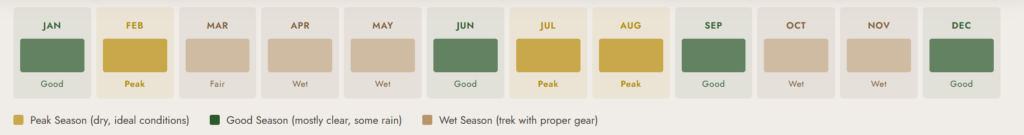
Prime Window: June–August (Long Dry Season)
The most reliable summit conditions of the year. Morning skies are often clear, allowing the fullest summit panoramas from Vittorio Emanuele Peak. Trails are at their firmest; the Bigo Bog is still muddy but more navigable than in the rains. This is the most popular window and the one we most strongly recommend for a first Mount Speke attempt. Book 3–6 months in advance for this period.
Second Best: December–February (Short Dry Season)
Often the least-visited period on the Central Circuit, with excellent summit conditions in December and January. The mountain is quieter, the huts less crowded, and wildlife observation in the lower forest is outstanding. Temperature in the upper zones is marginally colder than June–August, making the -5°C sleeping bag even more essential. February can see the onset of the long rains; monitor forecasts if departing in late February.
Avoid: March–May & September–November (Wet Seasons)
Summit attempts on Mount Speke during the wet season carry a significantly higher risk of being turned back by ice, mist, and unstable upper mountain conditions. The Bigo Bog becomes genuinely treacherous in the heaviest rains. While experienced teams with the right gear can complete the lower circuit sections, the success rates for reaching the summit drop substantially in the peak wet season. We can run this trek year-round but will always advise clients honestly about current conditions. WhatsApp our guides directly for a real-time conditions update.
What’s Included in Your Trek Package
Included
| ✔ UWA-registered lead mountain guide all 5 days |
| ✔ Trained porters (1 per 2 trekkers, max 15 kg per porter load) |
| ✔ All meals on the mountain: breakfast, packed lunch, dinner, and hot drinks |
| ✔ Accommodation in wooden mountain huts on the Central Circuit (4 nights) |
| ✔ Uganda Wildlife Authority (UWA) park entry fees and Central Circuit trail permit |
| ✔ Technical summit equipment: ropes, ice axes, helmets, and harnesses (Day 4 summit) |
| ✔ Free use of rubber gumboots at the Nyakalengija trailhead if required |
| ✔ Emergency first-aid kit carried by guide throughout the trek |
| ✔ Pre-trek briefing and gear check at Nyakalengija |
Not Included
| ✘ Tips and gratuities for guides and porters (strongly encouraged; see Tipping Guide) |
| ✘ Personal travel insurance and medical evacuation cover (mandatory) |
| ✘ Accommodation in Kasese before and after the trek |
| ✘ Transfers to/from the Nyakalengija trailhead (can be arranged on request) |
| ✘ Personal trekking and mountaineering gear (see Gear List section) |
| ✘ Alcoholic beverages and personal snacks beyond standard meals |
| ✘ Any costs arising from weather-related postponement or voluntary early descent |
| ✘ International flights, Uganda visa fees, and airport transfers |
Community ContributionA 10% portion of all trek proceeds from Rwenzori Trekking Safaris is directed to the local Bakonzo community in the Kasese region, supporting orphanages, primary schools, and homes. When you climb Mount Speke with us, your expedition directly sustains the mountain community that makes every trek possible. |
Full Packing & Gear List: 5-Day Mount Speke Expedition
The Mount Speke trek demands the most complete mountaineering kit of any 5-day Rwenzori itinerary. Technical summit equipment (ropes, ice axe, harness, and helmet) is provided by Rwenzori Trekking Safaris, but your personal gear must include cold-weather layers, a serious sleeping bag, and proper waterproofing. For the complete master guide, check out our Full Rwenzori Packing List, Footwear & Boot Guide, and How to Stay Warm at the Summit.
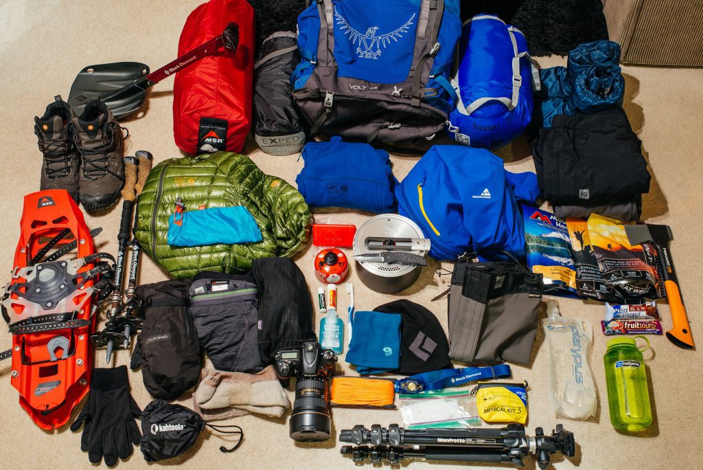
| Footwear & Gaiters | • Waterproof leather or synthetic mountaineering boots ankle support & crampon-compatible sole essential
• Rubber boots are available free at Nyakalengija trailhead for lower forest sections • Neoprene gaiters (full-length) critical for Bigo Bog and boggy upper valleys • Thick wool or synthetic trekking socks (3+ pairs) |
| Clothing Layers | • 3× moisture-wicking base layer shirts
• 1× mid-layer fleece or softshell jacket • 1× heavyweight insulated down jacket (mandatory at Bujuku Camp, 3,962 m, for sub-zero nights) • 1× hardshell waterproof jacket with sealed seams and hood • Waterproof shell trousers over trekking trousers • 1× thermal base layer leggings (for summit day and cold nights) |
| Head, Hands & Face | • Warm knit beanie or fleece hat (mandatory above 3,500 m)
• Helmet provided for summit day; bring your own if preferred • Waterproof insulated gloves (summit day temperatures can drop below 0°C) • Lightweight liner gloves for layering • UV-protection sunglasses or glacier goggles • High-SPF sunscreen and lip balm (intense UV at altitude) |
| Technical Summit Gear | • Ice axe provided; basic self-arrest technique training given by guide before summit day
• Harness provided for fixed-rope sections on Speke summit approach • Ropes managed by guide team • Helmet provided • Crampons may be required depending on conditions; the guide will assess at Bujuku |
| Pack & Carry | • Daypack 30–40 litres for summit day (porters carry main luggage to Bujuku)
• Dry bags or waterproof pack liner (mandatory multi-day wet exposure) • Trekking poles (collapsible; invaluable on boggy terrain and descents) • Hydration bladder or 2-litre water bottle minimum |
| Sleep & Camp | • Sleeping bag rated to -5°C minimum (Bujuku Camp nights can approach freezing)
• Sleeping liner for hygiene and extra warmth • Camp sandals or lightweight footwear for hut evenings |
| Health & Hygiene | • Personal first-aid kit: blister plasters, ibuprofen, antihistamine, Diamox (consult doctor)
• Altitude medication guidance: see Medical Guide for Diamox discussion • Insect repellent for lower forest section (Days 1–2) • Water purification tablets as backup guide team treats water at all camps • Biodegradable soap and hand sanitiser • Toilet paper and waste bag (leave no trace) |
| Electronics & Documents | • Headlamp with fresh batteries + spare set (mandatory for summit day 3–4 AM start)
• Camera in waterproof case / dry bag • Power bank (no electricity at any camp) • Emergency whistle and small mirror • Passport copy and booking confirmation for UWA park entry • Emergency contact card in pack lid |
Permits, Park Fees & Costs
Your Rwenzori Trekking Safaris package includes all Uganda Wildlife Authority (UWA) park entry fees and Central Circuit trail permits. You do not arrange permits independently.
Package-Included Cost Components
- UWA Park Entry: USD $35 per person per day (foreign non-resident rate) 5 days = $175 per trekker
- Central Circuit Trail Permit: Included in park fee structure
- Mountain Hut Fees: Nyabitaba, John Matte, and Bujuku hut nights included
- Guide Fee: UWA-registered lead guide for all 5 days
- Porter Fee: 1 porter per 2 trekkers for main luggage carry (15 kg max per load)
- Technical Summit Equipment: Ropes, ice axes, helmets, and harnesses for Day 4 summit
- All Meals: Full board breakfast, packed lunch, dinner, hot drinks throughout
Additional Budget to Plan For
- Guide & Porter Tips: USD $130–$180 per trekker (5 days). See our Porter Services & Tipping Guide
- Travel Insurance: Mandatory; must include medical evacuation cover to 5,000 m. See our Rwenzori Travel Insurance Guide
- Kasese Accommodation (pre/post trek): USD $30–$80 per night. See our pre- & post-trek accommodation guide.
- Kasese → Nyakalengija Transfer: ~USD $20–$30; arrangeable through Rwenzori Trekking Safaris
For the complete 2026 cost breakdown covering all trek fees, park charges, porter logistics, and budget planning guidance, see our Full Cost Guide: How Much Does It Cost to Climb the Rwenzori?
Getting There: Nyakalengija Trailhead
The Central Circuit trailhead is at Nyakalengija village, ~22 km from Kasese town. For complete logistics from Kampala and Entebbe, see our How to Get to the Rwenzori Mountains and Kasese Gateway Town Guide.
From Kasese to Nyakalengija (~22 km)
- Private vehicle: 30–40 minutes; pickup from your Kasese hotel arranged by Rwenzori Trekking Safaris
- Shared taxi/boda-boda: Available from Kasese town; ask at the taxi park for Nyakalengija
From Kampala to Kasese
- Private charter: 5–5 hours via Kampala–Fort Portal–Kasese highway
- Scheduled bus: 6–7 hours from Kisenyi Bus Terminal; several operators run daily
- Via Fort Portal: An excellent overnight stop. Fort Portal is 2–2.5 hours from Kasese, and it can be paired with chimpanzee trekking in Kibale.
From Entebbe International Airport: allow 7–8 hours by road. Arrive in Kasese the night before the trek begins for rest and final gear assembly.
Book Your Trek
Respond within Minutes
From
$1,200
per person
- Duration 5 Days / 4 Nights
- Group Size 1–15 people
- Start Point Nyakalengija
- Departures Year-round
- Summits Vittorio Emanuele/Ensonga/Johnston/Trident
No booking fee. Free cancellation up to 30 days before departure. We respond within Minutes.
Going Further: Related Rwenzori Expeditions
The 5-Day Mount Speke trek sits within a complete Rwenzori expedition portfolio. Here are the natural extensions and comparisons:
8-Day Rwenzori 3-Peaks Trek: Stanley, Speke & Baker
$1850 Per Person
This is for those who want to climb multiple major Rwenzori summits in a single expedition.
This is for those who want to climb multiple major Rwenzori summits in a single expedition.
5-Day Trek to Edward Peak (Mount Baker)
$1000 Per Person
An alternative 5-day Central Circuit summit targeting Mount Baker (4,843 m) at Edward Peak.
An alternative 5-day Central Circuit summit targeting Mount Baker (4,843 m) at Edward Peak.
13-Day 6-Peaks Grand Expedition
$3,350 Per Person
Summit all six major Rwenzori peaks in one continuous expedition.
Summit all six major Rwenzori peaks in one continuous expedition.
Rwenzori Hike (7 Days Central Circuit)
$1400 Per Person
The classic Rwenzori summit trek. Same approach as Speke, extra acclimatisation, and Africa's third-highest summit at 5,109 m.
The classic Rwenzori summit trek. Same approach as Speke, extra acclimatisation, and Africa's third-highest summit at 5,109 m.
Frequently Asked Questions: 5-Day Mount Speke Trek, Rwenzori Mountains
How difficult is the 5-Day Mount Speke trek in the Rwenzori Mountains?
The 5-day Mount Speke trek is rated strenuous to technically demanding; it is one of the most challenging mountain experiences available in Uganda. Days 1–3 on the Central Circuit Trail involve prolonged hiking through dense forest, bamboo zones, and the notoriously boggy upper valleys, with cumulative altitude gain exceeding 2,500 m from the trailhead to Bujuku Camp at 3,962 m. Day 4 is the summit day: a round trip of 10–12 km from Bujuku, climbing from 3,962 m to the Vittorio Emanuele summit at 4,890 m via Groundsel Gully and the Scott Elliot Pass approach. This section involves fixed ropes, a harness, ice axe use, and exposure to genuine high-altitude conditions, including sub-zero temperatures and potential wind chill. Day 5 is a long 15 km descent back to Nyakalengija. This trek is not for casual hikers; it demands serious mountaineering ambition, strong physical fitness, and mental resilience. We strongly recommend prior experience at altitude and comfort on steep, technical terrain.
Do I need technical climbing experience to summit Mount Speke (4,890 m)?
Yes, the summit day of the 5-day Mount Speke trek involves technical mountaineering sections that go beyond standard hiking. The ascent from Bujuku Camp to Vittorio Emanuele Peak passes through Groundsel Gully and approaches the Scott Elliot Pass, where fixed ropes, a harness, and ice axe use are required. Your guide will provide technical equipment (ropes, a harness, an ice axe, and a helmet) and brief you on technique before the summit attempt. However, prior experience with rope use, basic crampon technique, and steep exposure is a significant advantage. Trekkers who have completed multi-day alpine routes at 3,500 m+ or undertaken guided glacier walks will find the transition more manageable. If you have no prior experience with technical mountain terrain, we recommend beginning with the 7-Day Margherita Peak climb via the Central Circuit, which provides a more extensive acclimatization profile before the summit. See our full How Hard Is the Rwenzori Trek? guide for an honest difficulty comparison.
What is Mount Speke's summit height, and how does it compare to other Rwenzori peaks?
Mount Speke’s highest point, Vittorio Emanuele Peak, stands at 4,890 m (16,040 ft) above sea level. It is the second-highest mountain in the Rwenzori range, surpassed only by Mount Stanley, whose Margherita Peak reaches 5,109 m. Within the broader context of African high-altitude mountaineering, Mount Speke’s Vittorio Emanuele summit is the fourth-highest point on the continent after Kilimanjaro (5,895 m), Mount Kenya’s Batian Peak (5,199 m), and Margherita Peak on Mount Stanley (5,109 m). Other notable summits on Mount Speke include Ensonga (4,865 m), Johnston (4,834 m), and Trident (4,572 m). The mountain’s multiple summits and deeply glaciated character make it one of the most complex and visually dramatic peaks in equatorial Africa.
What camps are on the 5-Day Mount Speke trek itinerary?
The 5-Day Mount Speke trek uses three camps on the Central Circuit Trail. Nyabitaba Hut (2,651 m) is the first overnight stop, a wooden mountain hut set in the Afro-montane forest above the Mubuku River valley, reached after a 10 km, day 1 approach. John Matte Hut (3,380 m) is the second camp, deeper in the heather zone above the bamboo, with panoramic views toward Mount Stanley and Margherita Peak on clear days; this is where the serious altitude begins. Bujuku Hut (3,962 m) is the highest camp and base for the Mount Speke summit attempt, an alpine lake setting surrounded by giant groundsels and senecio trees, with views of Lake Bujuku framed by Mount Baker and the walls of Mount Stanley. All huts feature wooden bunk-bed sleeping, basic mattresses, and blankets. Your guide team prepares meals at each camp. No electricity or phone signal at any camp.
What is the Scott Elliot Pass, and what role does it play in the Mount Speke summit route?
Scott Elliot Pass (4,372 m) is a major high-alpine pass on the Central Circuit Trail in Rwenzori Mountains National Park, situated between Mount Speke and Mount Baker. It is named after the Scottish botanist and explorer J.E.T. Scott Elliot, who conducted early botanical surveys in the Rwenzori in the 1890s. On the 5-Day Mount Speke summit day, the approach from Bujuku Camp traverses the terrain below and near Scott Elliot Pass before entering the Groundsel Gully approach to Vittorio Emanuele Peak. The pass area is characterised by dramatic senecio forests, scree fields, and remnant ice, a landscape that is simultaneously one of the most otherworldly and most demanding sections of the entire Central Circuit. The altitude (4,372 m) and the technical nature of the terrain above make this zone one of the sections where guide expertise and correct equipment are essential.
What altitude sickness risk exists on the 5-Day Mount Speke trek?
The 5-Day Mount Speke trek carries a significant altitude risk, particularly from Day 3 onward. By Day 3, trekkers reach Bujuku Camp at 3,962 m, a level at which acute mountain sickness (AMS) is a meaningful risk for altitude-sensitive individuals. The summit day pushes to 4,890 m, where acute mountain sickness (AMS), high-altitude pulmonary edema (HAPE), and high-altitude cerebral edema (HACE) all become real concerns. The rate of ascent on this itinerary is aggressive for a 5-day program, more rapid than the 7-day Central Circuit itinerary, which significantly increases altitude risk. Key precautions: move at your guide’s pace, drink 3–4 liters of water per day, eat well at every meal, and take the standard AMS indicators seriously (persistent headache, nausea, loss of coordination, and confusion). Discuss Diamox (acetazolamide) prophylaxis with your doctor before departure. Descend immediately if severe symptoms develop; do not push through on summit day if you are not feeling well. See our full Altitude Acclimatization Guide and Medical Guide to Rwenzori Trekking.
Is there glacier travel on the Mount Speke 5-Day trek?
The Mount Speke summit approach on this 5-day itinerary does not involve extensive glacier crossing in the way that the 7-Day Margherita Peak summit day does. However, the terrain above Bujuku Camp and near the Scott Elliot Pass area can include snow, ice patches, and remnant glacial surfaces depending on seasonal conditions, particularly between June and February. Crampons may be required depending on conditions when you attempt the summit; your guide will assess this at Bujuku Camp the night before and equip you accordingly. The Rwenzori glaciers have retreated by over 80% in the last century due to climate change, but residual ice and seasonal snowfall still make technical equipment mandatory on summit day. For a detailed overview of glacier conditions on the Rwenzori, see our Glacier Retreat & Climate Change guide.
What wildlife and flora will I see on the 5-Day Mount Speke trek via the Central Circuit?
The 5-Day Mount Speke trek passes through all five of the Rwenzori’s major vegetation zones, offering one of the most complete ecological cross-sections of any trekking itinerary on the mountain. In the Afro-Montane forest (Days 1–2), expect blue monkeys, Rwenzori turaco, African green broadbill, and three-horned chameleons. The bamboo zone between Nyabitaba and John Matte is alive with birdsong and Rwenzori turaco calls. Above John Matté, the heather zone introduces giant tree heather (Erica arborea) smothered in moss and old man’s beard. The Bigo Bog crossed on Day 3 is one of Africa’s most surreal landscapes: a high-altitude wetland filled with giant lobelias (Lobelia wollastonii) rising 2–3 m, giant groundsels (Senecio adnivalis), and carpets of sphagnum moss. Near Bujuku Camp and on the summit approach, giant groundsels (Senecio adnivalis) stand like prehistoric sentinels in the Afro-alpine zone, one of the most photographed subjects in the entire Rwenzori range.
How does the 5-Day Mount Speke trek compare to the 7-Day Margherita Peak climb?
The 5-day Mount Speke trek and the 7-day Margherita Peak climb share the same Central Circuit Trail approach as far as Bujuku Camp but diverge significantly in ambition, acclimatization, and technical demand. The 7-Day Margherita Peak climb (full Central Circuit) is the standard recommended route for first-time Rwenzori summiteers: it includes two additional rest/acclimatization days, traverses more of the circuit (including Elena Camp at 4,541 m), and provides a gentler altitude progression before the Margherita summit attempt at 5,109 m. The 5-day Mount Speke trek is more compressed and technically demanding for its summit approach but targets a lower summit (4,890 m vs. 5,109 m for Margherita). Serious mountaineers who have prior high-altitude experience may prefer the Mount Speke expedition as a standalone objective. For a detailed comparison of all Rwenzori routes, see our Central Circuit Trail guide and our Routes & Dates overview.
What is the best time of year to attempt the 5-Day Mount Speke trek?
The best months for the 5-day Mount Speke trek are December to February and June to August, Uganda’s two dry seasons. During these windows, summit day conditions on Mount Speke are most stable: clearer mornings, firmer trails, lower precipitation, and better visibility from Vittorio Emanuele Peak across Lake Bujuku and toward Mount Stanley. June–August is the most popular summit window and sees the most consistent weather on the upper mountain. December–January offers excellent conditions with fewer trekkers. The wet seasons (March–May and September–November) are technically possible but bring higher precipitation, more challenging boggy terrain in the Bigo Bog area, and less stable summit conditions. Summit attempts are more frequently turned back due to mist and ice. That said, the Rwenzori is famously one of the wettest mountain ranges in Africa year-round, and no one can guarantee perfect weather on any date. A full month-by-month guide is available in our Best Time to Visit the Rwenzori guide.
How do I get to the Nyakalengija trailhead for the Mount Speke trek?
The Central Circuit trailhead at Nyakalengija is located approximately 22 km from Kasese town along the road toward the Rwenzori foothills, a 30–40 minute drive by private vehicle. Rwenzori Trekking Safaris can arrange transfers directly from Kasese. From Kampala, Kasese is approximately 4.5–5 hours by private charter vehicle via the Kampala–Fort Portal–Kasese highway, or 6–7 hours by scheduled bus from Kisenyi Bus Terminal. From Entebbe International Airport, allow 7–8 hours by road. We strongly recommend arriving in Kasese the night before the trek begins, both to rest and to complete final gear checks. Full logistics are covered in our How to Access to the Rwenzori Mountains guide and Kasese Gateway Town Guide.
How much should I tip my guides and porters on the 5-Day Mount Speke trek?
Tipping is not included in the trek package but is a critically important part of Rwenzori trekking culture. Guides and porters are local Bakonzo community members for whom trekking income is a primary livelihood source. For a 5-day expedition with technical summit involvement, recommended guidelines are: USD $15–$20 per day for your lead guide and USD $5–$8 per day per porter. For a solo trekker with one guide and two porters over 5 days, a total tip budget of approximately USD $130–$180 is appropriate. Tips are distributed at the trailhead on the final day. For full guidance on fair wages, porter welfare, and tipping etiquette, see our Porter Services & Tipping Guide.
Vittorio Emanuele Peak Awaits. Five Days That Will Define You.
The second-highest Rwenzori summit is Mount Speke. One of the least-climbed 4,000 m peaks in equatorial Africa.
Our guides have led every camp and every technical section along this route.
Honest assessment. Technical expertise. Community-rooted trekking.
WhatsApp: +256 773 256 104
Email: rwenzoritrekkingsafaris@gmail.com
Request Your Mount Speke Expedition Quote →
10% of all trek proceeds support Bakonzo community schools, orphans & homes.