Summit Weismann’s Peak (4,620m) via the remote Kilembe Trail in 6 days. A point-to-point traverse through all Rwenzori ecozones. Full itinerary, camps & costs.
6-Day Weismann's Peak Trek via Kilembe Trail | Rwenzori Trekking
6-Day Rwenzori Weismann’s Peak Expedition via Kilembe Trail. (4,620 m)
The Kilembe Trail’s Finest Challenge Six Days, One Remote Summit, Zero Crowds.
Few treks in East Africa combine the raw verticality, ecological drama, and genuine remoteness of this six-day Kilembe Trail expedition to Weismann’s Peak (4,620m). You enter through cathedral forest at the foot of the Nyamwamba Valley, climb through every ecological zone the Rwenzori possesses, cross Bamwanjara Pass at 4,450 m with three of Africa’s greatest peaks surrounding you, and summit a striking blade of rock above glacial valleys, then descend a completely different valley back to civilization. It is a point-to-point mountain traverse in every sense and one of the most varied alpine routes in Uganda.
Join a 6-day guided Rwenzori trek to Weismann’s Peak via the Kilembe Trail. The trek includes forests, alpine bogs, high passes, lakes, and a dramatic descent into the Nyamwamba Valley.
This 6-day Rwenzori Mountains expedition to Weismann’s Peak (4,620 m) follows the scenic and demanding Kilembe Trail, offering one of the most diverse and immersive high-altitude trekking experiences in East Africa. The route traverses every major ecological zone of the Rwenzoris from dense Afro-montane rainforest and bamboo jungles to giant heather forests, alpine boglands, glacial valleys, and exposed high passes before descending dramatically through the remote Nyamwamba Valley.
This expedition starts at Trekkers Hostel Kilembe (also known as Rwenzori Backpackers Hostel, Kyanjuki), which is about 30–40 minutes from Kasese town and 8–9 hours by car from Kampala.
Unlike the Central Circuit, which loops politely around Mount Stanley, the Kilembe Trail is raw and vertical. It follows the Nyamwamba Valley straight into the heart of the Rwenzori Mountains. The landscape is characterized by rapid terrain changes, unpredictable weather patterns, and an untamed feel that modern trekkers rarely experience.
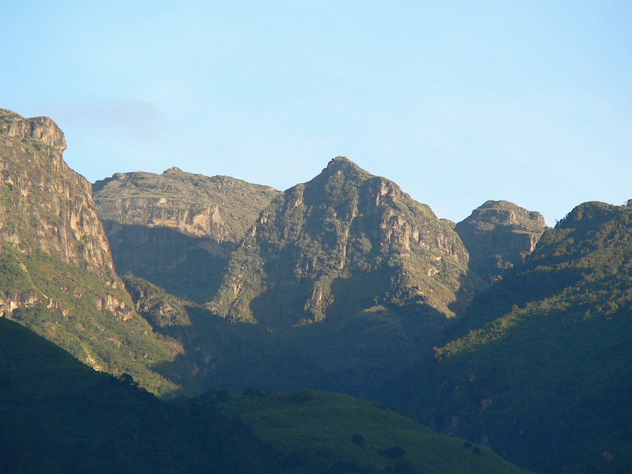
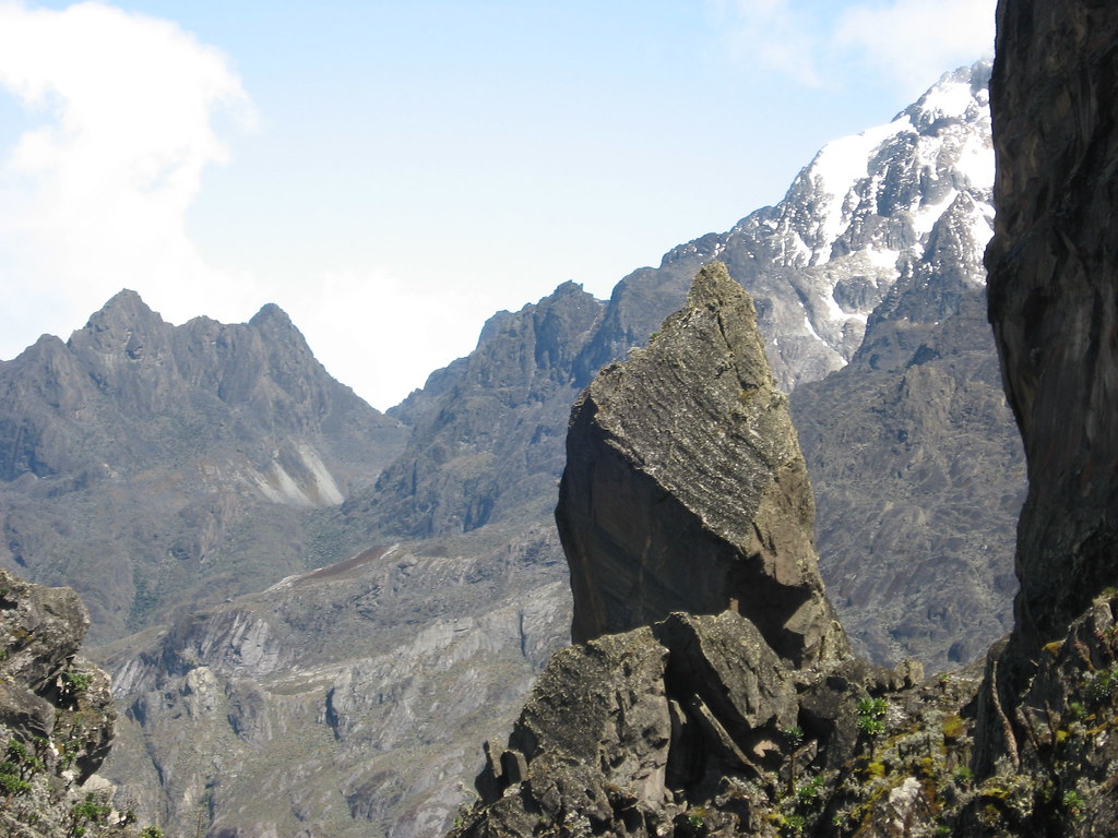
Weismann’s Peak, part of the Mount Speke massif, is one of the most visually striking summits in the Rwenzori Mountains. It rises like a blade above glacial valleys and alpine bogs, framed by McConnell’s Prong and the jagged ridges of Mount Baker and Stanley.
6-Day Weismann’s Peak Trek: At-a-Glance
| Duration | 6 days / 5 nights |
| Total Distance | ~50 km point-to-point (Kilembe Trailhead → Nyamwamba Valley exit) |
| Maximum Elevation | 4,620 m, Weismann’s Peak, Mount Luigi di Savoia massif |
| Key High Point | Bamwanjara Pass: 4,450 m (crossed on Day 4) |
| Total Ascent | ~3,170 m cumulative |
| Total Descent | ~3,170 m cumulative (point-to-point via Nyamwamba Valley) |
| Difficulty | Hard prior multi-day trekking experience required |
| Trail Used | Kilembe Trail (Rwenzori Mountains National Park, southern approach) |
| Start Point | Kilembe Trailhead / Rwenzori Backpackers Hostel, ~35km from Kasese |
| End Point | Nyamwamba Valley trailhead exit (different from start point-to-point) |
| Best Months | January–February & June–August (drier windows) |
| Group Size | 2–10 trekkers (private departures available on any date) |
| Accommodation | Mountain huts: Sine, Mutinda, Bugata, Hunwick’s, Kiharo |
| Summit Type | High-altitude trekking peak, no technical glacier equipment required |
| Price Indicator | From $1,200 per person |
| Park Authority | Uganda Wildlife Authority (UWA) |
Why Choose the 6-Day Weismann’s Peak Expedition via the Kilembe Trail?
Weismann’s Peak sits at 4,620 m on the Mount Luigi di Savoia massif, one of the six named summits of the Rwenzori Mountains, and it is among the least-climbed of the Rwenzori’s accessible high peaks. That is not because it is second-rate. It is because the Kilembe Trail that leads to it is rawer, steeper, and less trafficked than the Central Circuit. Trekkers who choose this route are not the same people who want a well-worn, signposted mountain experience. They want something wilder and they get it.
The Kilembe Trail is a fundamentally different character of a route from anything on the central circuit. It begins at the Rwenzori Backpackers Hostel in Kilembe, a former copper-mining settlement at the base of the Nyamwamba Valley, and drives straight into the mountain range on a direct, near-vertical assault. The approach is uncompromising: you gain 1,146 m on Day 1 through some of the thickest Afro-montane forest in the Rwenzori, passing waterfalls, giant mossy trees, and rich primate habitat before reaching Sine Camp (2,596 m). By Day 3 you are camped at Bugata Camp (4,100 m), one of the best-equipped high camps in the range, with views across Lake Kopello and directly up to Weismann’s distinctive summit blade.
What makes this particular 6-day itinerary exceptional is its structure as a true traverse. You enter via the Nyamwamba Valley on the Kilembe Trail, summit Weismann’s Peak on Day 5 after crossing the dramatic Bamwanjara Pass (4,450 m) on Day 4, then descend out through the remote upper Nyamwamba Valley on Day 6, a completely different descent from a completely different direction. The final day through the Nyamwamba Valley gorge, with its cascading waterfalls, moss-covered rock faces, and increasing primate activity as altitude drops, is one of the most dramatic finale days in Rwenzori trekking. You do not retrace a single step of the ascent. This is a genuine mountain traverse.
From Hunwick’s Camp (3,974 m) on the night before the summit, the panorama across the central Rwenzori massifs is extraordinary: Mount Stanley (5,109 m), Mount Baker (4,843 m), and the full sweep of the high ridge are visible in all directions. This is not a crowded mountain. The Kilembe Trail sees a fraction of the trekkers that the Central Circuit handles, which means your summit morning is likely to be yours alone, in a silence broken only by wind and the occasional raven. For experienced trekkers who value solitude as much as scenery, this route is without equal in the Rwenzori Mountains.
Full Day-by-Day Itinerary: 6-Day Weismann's Peak Trek via Kilembe Trail
DAY 1: KILEMBE TRAILHEAD → SINE CAMP (1,450 m → 2,596 m) | ~9.5 km
Hiking time: 6–7 hours | Elevation gain: +1,146m | Overnight: Sine Camp (2,596m)
Kilembe: The Kilembe Trail Begins
Your 6-day Rwenzori Weismann’s Peak expedition begins at the Rwenzori Backpackers Hostel (also known as Trekkers Hostel Kilembe) in Kyanjuki, a small settlement approximately 35 km from Kasese town (about 40 minutes by road) at the base of the Nyamwamba Valley. Arriving the evening before is strongly recommended: guide introductions, porter load allocation, permit verification, and equipment checks are all completed at Kilembe, and an early-morning departure on Day 1 is essential to reach Sine Camp in good time.
The pre-trek briefing covers the route structure, altitude management principles, emergency protocols, and the critical difference between this Kilembe Trail approach and the more familiar Central Circuit. Kilembe Trail trekkers should understand from the outset that the Kilembe Trail is a more remote route with fewer facilities, more exposed terrain above the treeline, and weather that can change rapidly. Your guide will cover all of these details. Pay attention.
The Nyamwamba Valley Forest Ascent
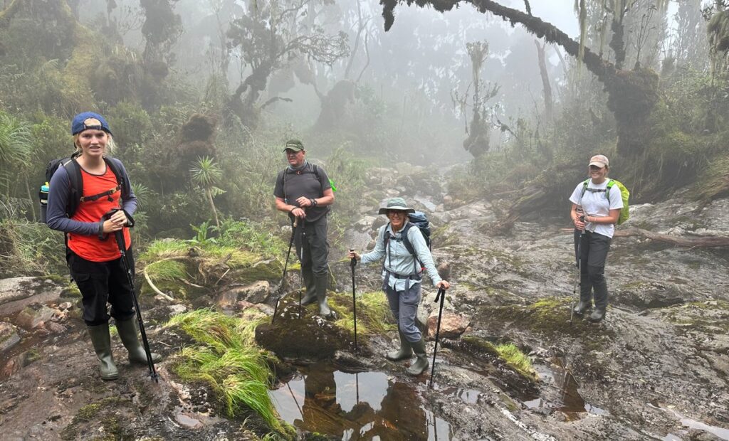
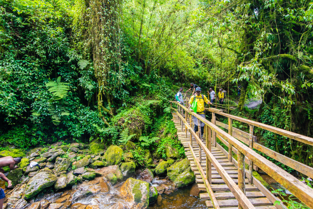
The trail departs immediately into the lower Nyamwamba Valley, one of the most ecologically dense environments in the Rwenzori Mountains. The valley floor at Kilembe sits in a bowl of Afro-montane rainforest that has received protection under Rwenzori Mountains National Park (a UNESCO World Heritage site) since 1994. The trees here are ancient hardwoods draped in epiphytic moss and lichen; the floor is carpeted in ferns, and the calls of forest birds fill the canopy before full daylight.
Primate activity is excellent in the lower Nyamwamba Valley. Black-and-white colobus monkeys (Colobus guereza) move through the canopy in groups; blue monkeys (Cercopithecus mitis) forage in the mid-canopy; and the culturally significant L’Hoest’s monkey (Allochrocebus lhoesti), a species of particular concern due to habitat loss, is occasionally spotted in family groups. Distant chimpanzee calls sometimes echo across the valley from adjacent forest fragments, though direct sightings are rare on this trail.
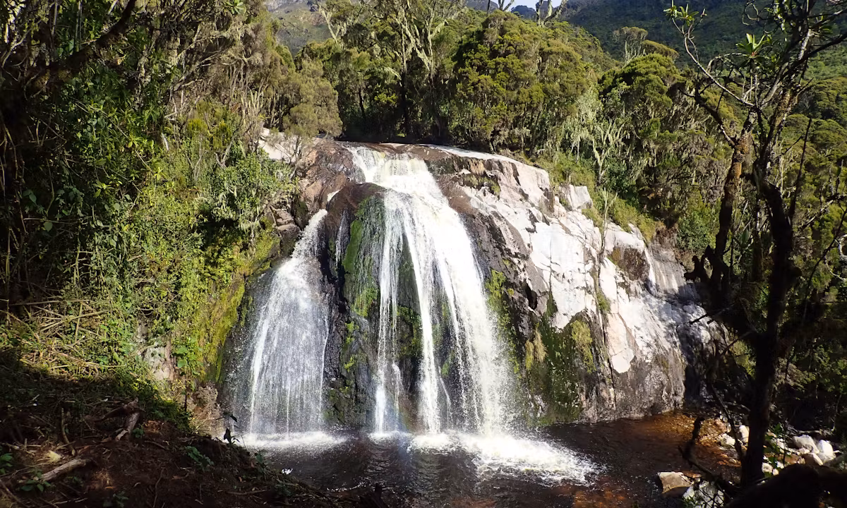
The trail climbs steadily through the forest, crossing several clear mountain streams and passing beneath moss-covered rock outcrops. A short detour from the main trail leads to Enock’s Falls, a beautiful cascade framed by dense riparian forest, worth the few extra minutes. Above the falls, the forest deepens and the gradient increases. Bamboo begins to appear in patches above 2,000 m, signaling the start of the transition zone. Sine Camp (2,596 m) is reached after 6–7 hours in a sheltered clearing beside a stream, surrounded by tree heather beginning to show through the upper bamboo.
Day 1 Highlights
- Departure briefing at Rwenzori Backpackers Hostel, Kilembe
- Lower Nyamwamba Valley forest colobus, blue monkeys, L’Hoest’s monkeys
- Enock’s Falls a beautiful waterfall accessible on a short detour
- Rich botanical diversity: mosses, orchids, giant ferns, towering hardwoods
- Arrival at Sine Camp (2,596m) in the upper bamboo/lower heather zone
DAY 2: SINE CAMP → MUTINDA CAMP (2,596 m → 3,588 m) | ~6.1 km
Hiking time: 5–7 hours | Elevation gain: +992m | Overnight: Mutinda Camp (3,588 m)
Into the Bamboo and Heather Zones
Day 2 of the Weismann’s Peak trek is shorter in distance but substantial in elevation gain and ecological variety. After breakfast at Sine Camp, the trail leaves the upper bamboo and immediately climbs into denser tree heather (Erica arborea and Erica trimera), the gnarled, lichen-draped woodland that characterizes the Rwenzori between roughly 2,800 m and 3,500 m. Usnea lichen (‘old man’s beard’) hangs from every branch; the forest is permanently dripping, the light filtered through pale green fronds. Three-horned chameleons (Trioceros johnstoni) an endemic Rwenzori species are often spotted at eye level on heather branches in this zone. Move slowly and watch the vegetation carefully.
The trail crosses a series of ridges, each one revealing a slightly higher and more open view back down the Nyamwamba Valley toward Kasese and, on clear days, the western Rift Valley escarpment beyond. These ridge crossings are among the most satisfying moments of the Kilembe Trail’s lower sections, brief windows of panorama in an otherwise enclosed mountain landscape. Between ridges, the path dips into valley folds, crossing clear mountain streams that run fast over mossy boulders.

Mutinda Lookout Acclimatisation Option
Mutinda Camp (3,588m) sits beside a mountain stream in a wide, sheltered bowl of alpine heather. After arriving in the early-to-mid afternoon, your guide will offer an optional acclimatization hike to Mutinda Lookout (3,975 m), a ridge point 387 m above camp that delivers one of the most comprehensive panoramic views available from any non-summit point on the Kilembe Trail. From the lookout on a clear afternoon, you can see the Rwenzori Mountains spread north and east; Kasese town visible far below in the valley; Lake George glinting on the horizon; and the first glimpse of the high peaks Weismann’s Peak, Baker, and Stanley that form the target of the coming days.
This acclimatization hike is strongly recommended. The ‘climb high, sleep low’ principle, gaining altitude then descending to sleep at a lower elevation, is the most effective single strategy for preventing altitude sickness. The 2–3 hour round trip to Mutinda Lookout and back to camp implements this principle without adding to the following day’s load. Read the full Rwenzori acclimatization guide for the complete altitude management strategy.
Day 2 Highlights
- Ascent through the Heather-Rapanea zone lichen-draped trees and endemic chameleons
- Ridge crossings with panoramic views back down the Nyamwamba Valley
- Optional acclimatisation hike to Mutinda Lookout (3,975m) for panoramic views
- Views of the Rwenzori high peaks, Kasese town, and Lake George
- Overnight at Mutinda Camp (3,588m) beside a mountain stream
DAY 3: MUTINDA CAMP → BUGATA CAMP (3,588 m → 4,100 m) | ~8.6 km
Hiking time: 4–6 hours | Elevation gain: +512 m | Overnight: Bugata Camp (4,100 m)
Into the Afro-Alpine Zone: Giant Lobelias and Open Valleys
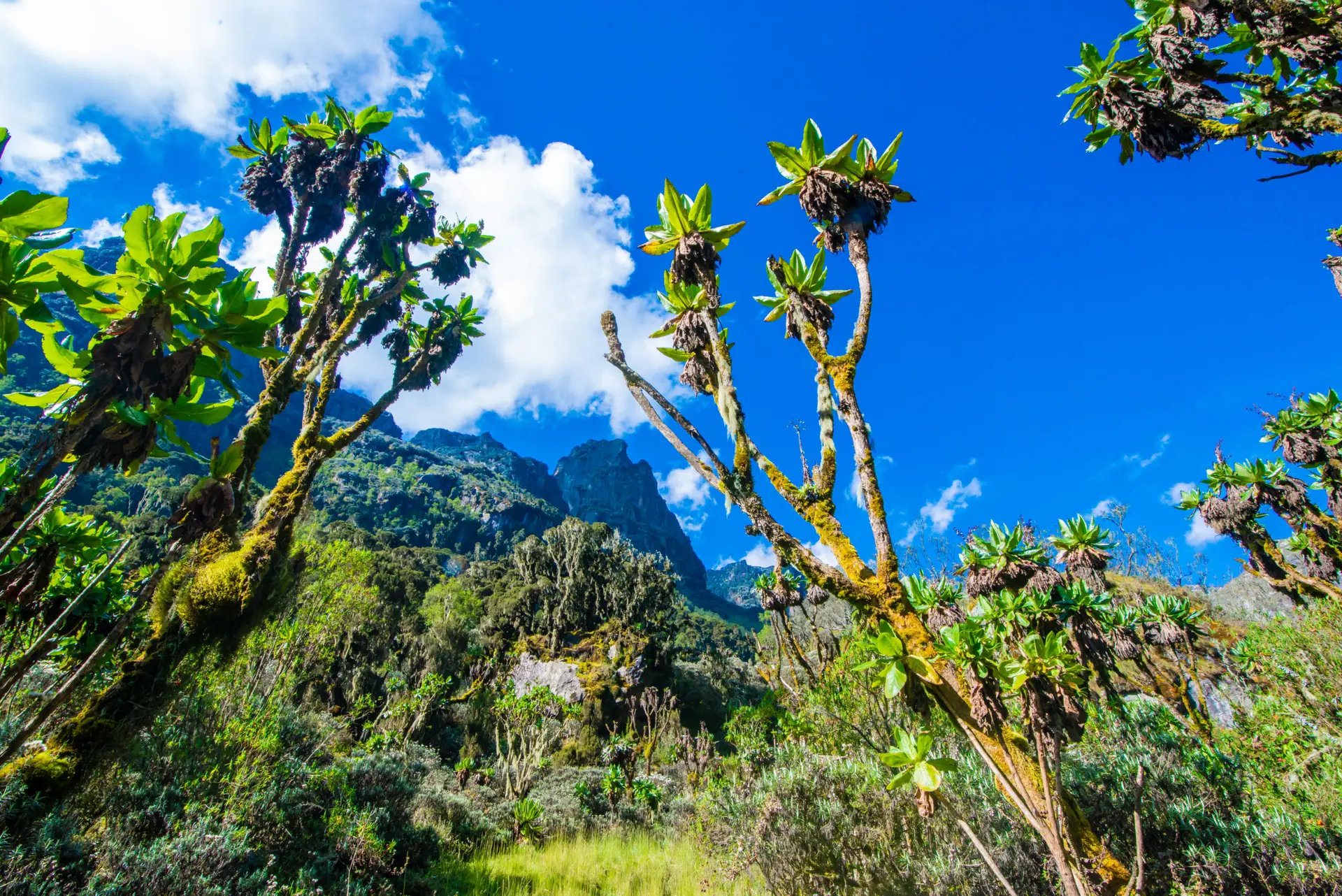
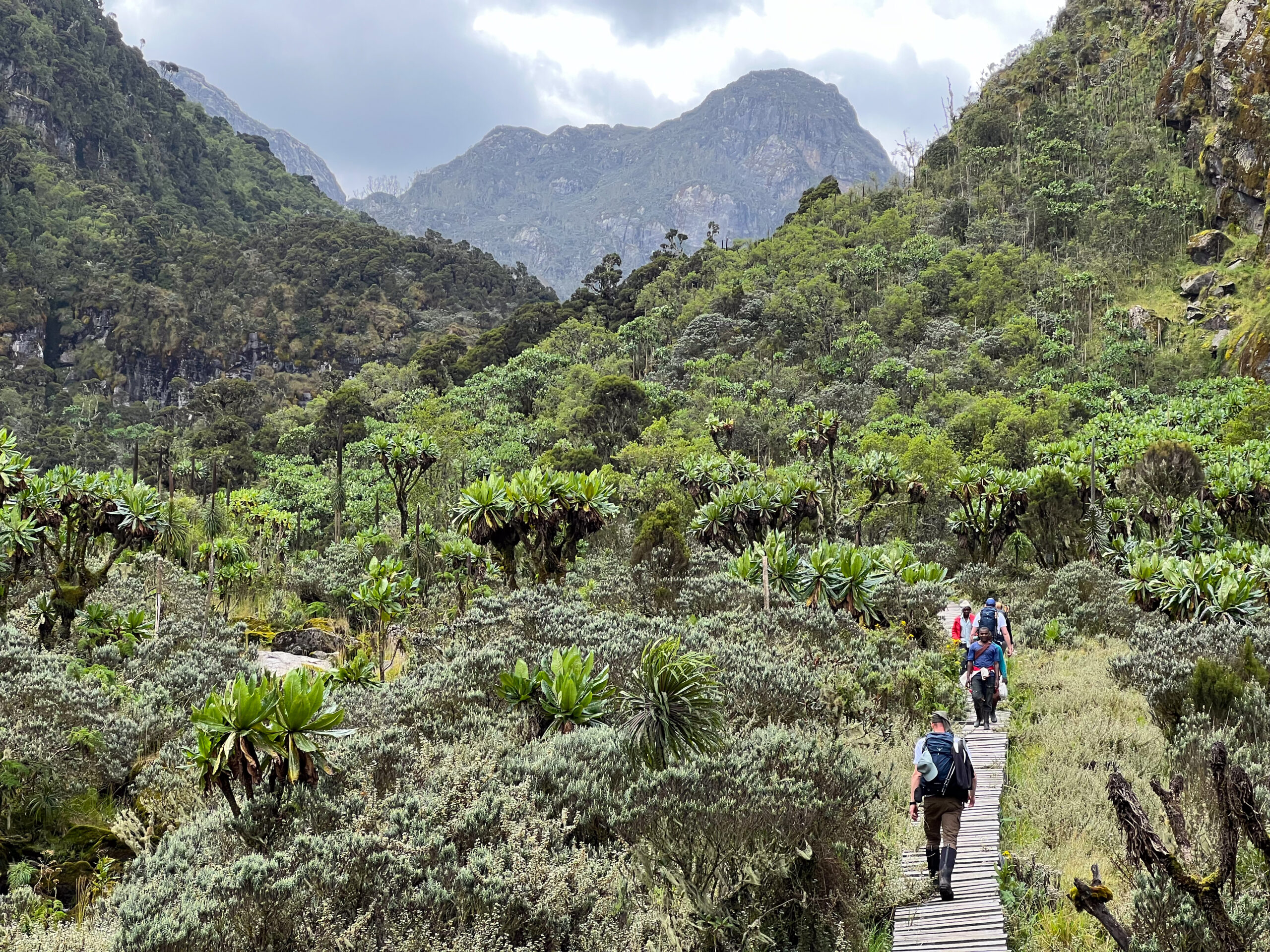
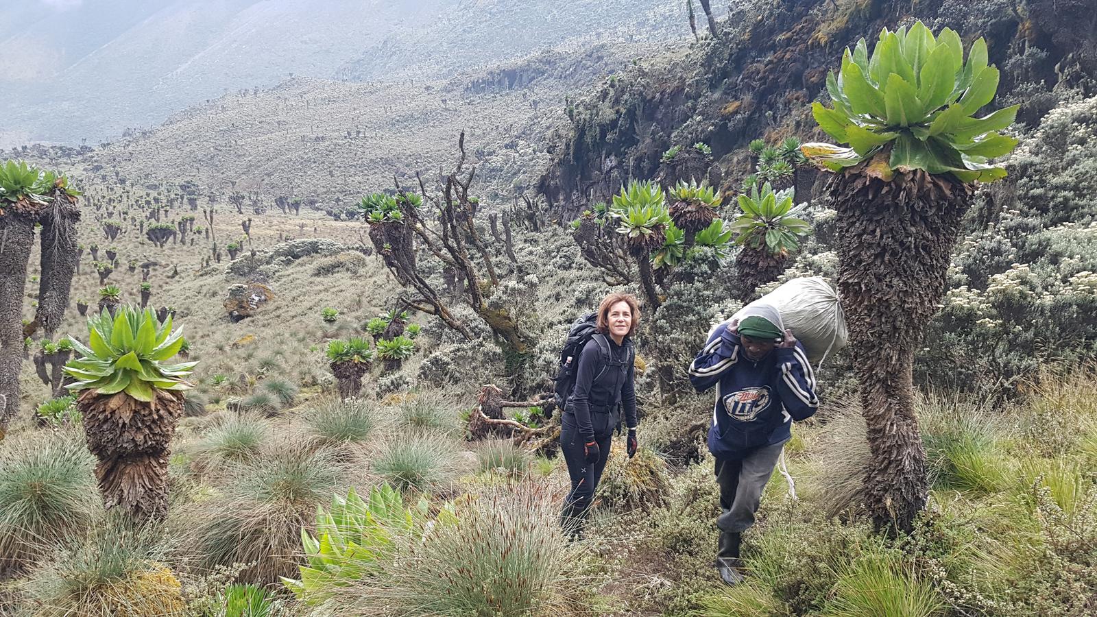
Day 3 is the most visually dramatic day of the ascent, the day the Rwenzori stops looking like a mountain and starts looking like something from another planet. Above Mutinda Camp, the tree heather gives way rapidly to open Afro-alpine moorland: the tussock grass, ancient peat bogs, and the extraordinary giant plant life that makes the Rwenzori Mountains one of the most botanically distinctive landscapes on Earth. Giant lobelias (Lobelia wollastonii) stand 4–5 metres tall, their silver rosettes holding droplets of water that catch the morning light. Giant groundsels (Senecio adnivalis) form architectural stands across the open moorland. Everlasting flowers (Helichrysum stuhlmannii) carpet the ground between them.

The trail crosses the open Mutinda Valley before climbing into the Namusangi Valley (approximately 3,840 m), where a series of dramatic waterfalls cascade down sheer rock faces, some of them visible from hundreds of metres away, their sound preceding them by minutes on the still mountain air. The transition from heather to fully open alpine terrain happens somewhere in the Namusangi Valley, and the change in scale is immediate: suddenly you are small in a large landscape, with cloud shadows moving across open ground and the first real views of Weismann’s Peak and the surrounding ridges above Bugata.
Arrival at Bugata Camp
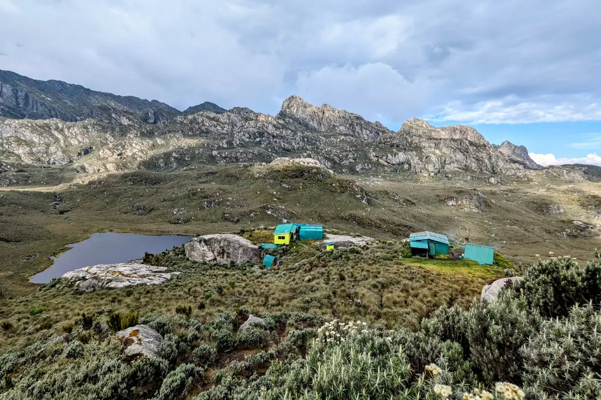
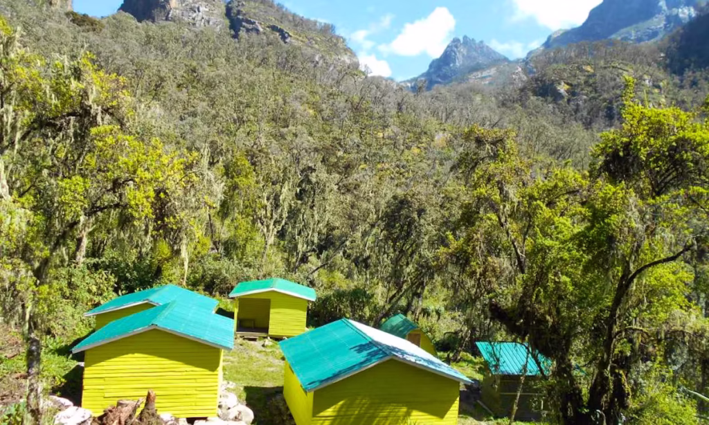
Bugata Camp (4,100 m) is one of the best-equipped high camps in the Rwenzori Mountains, a fact that surprises many trekkers expecting a basic mountain hut after the wilder lower sections of the Kilembe Trail. The camp features sleeping huts with bunk platforms, a kitchen and dining shelter, solar lighting (one of the few high camps in the range with this feature), warm shower facilities, and critically for this elevation, emergency helicopter access landing capacity. This is the camp where your insurance documentation matters: at 4,100 m, any evacuation becomes significantly more complex and expensive. Review our Rwenzori travel insurance guide to confirm your coverage before departure.
From Bugata, the views are extraordinary: Lake Kopello glints in the valley below. Weismann’s Peak rises like a blade above the alpine moorland to the north, and Bamwanjara Pass, tomorrow’s crossing, is visible as a notch on the ridge to the east, flanked by the jagged rock walls of the Rwenzori’s central massifs. The Rwenzori Red Forest Duiker (Cephalophus nigrifrons rubidus), a subspecies that only lives in these mountains, is sometimes seen around Bugata Camp at dusk, coming out of the remaining vegetation patches to feed. Ravens and alpine choughs work the open ground around the huts.
Day 3 Highlights
- Full transition into the Afro-alpine moorland giant lobelias and groundsels
- Namusangi Valley waterfalls dramatically cascade down sheer rock faces
- First clear views of Weismann’s Peak, Bamwanjara Pass, and the central Rwenzori massifs
- Lake Kopello visible below Bugata Camp a glacially carved tarn
- Bugata Camp (4,100 m): solar-lit, warm showers, emergency helicopter access
DAY 4: BUGATA CAMP → BAMWANJARA PASS → HUNWICK'S CAMP (4,100m → 4,450m → 3,974m) | ~8.3 km
Hiking time: 7–9 hours | Gain: +350 m to pass | Net descent to Hunwick’s: −476 m | Overnight: Hunwick’s Camp (3,974 m)
The Climb to Bamwanjara Pass (4,450m)
Day 4 of the Weismann’s Peak expedition is the crossing of the watershed, the moment you move from the Kilembe approach side to the inner Rwenzori world beyond. Breakfast at 6:30 AM and departure by 7:00. The trail leaves Bugata Camp and climbs a long ridge toward Bamwanjara Pass at 4,450 m. The ascent gains 350m from camp and takes approximately 3–4 hours. The terrain is rocky, open, and exposed to the full force of whatever weather is moving across the range, which is a significant consideration at this elevation.
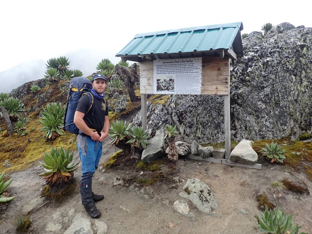
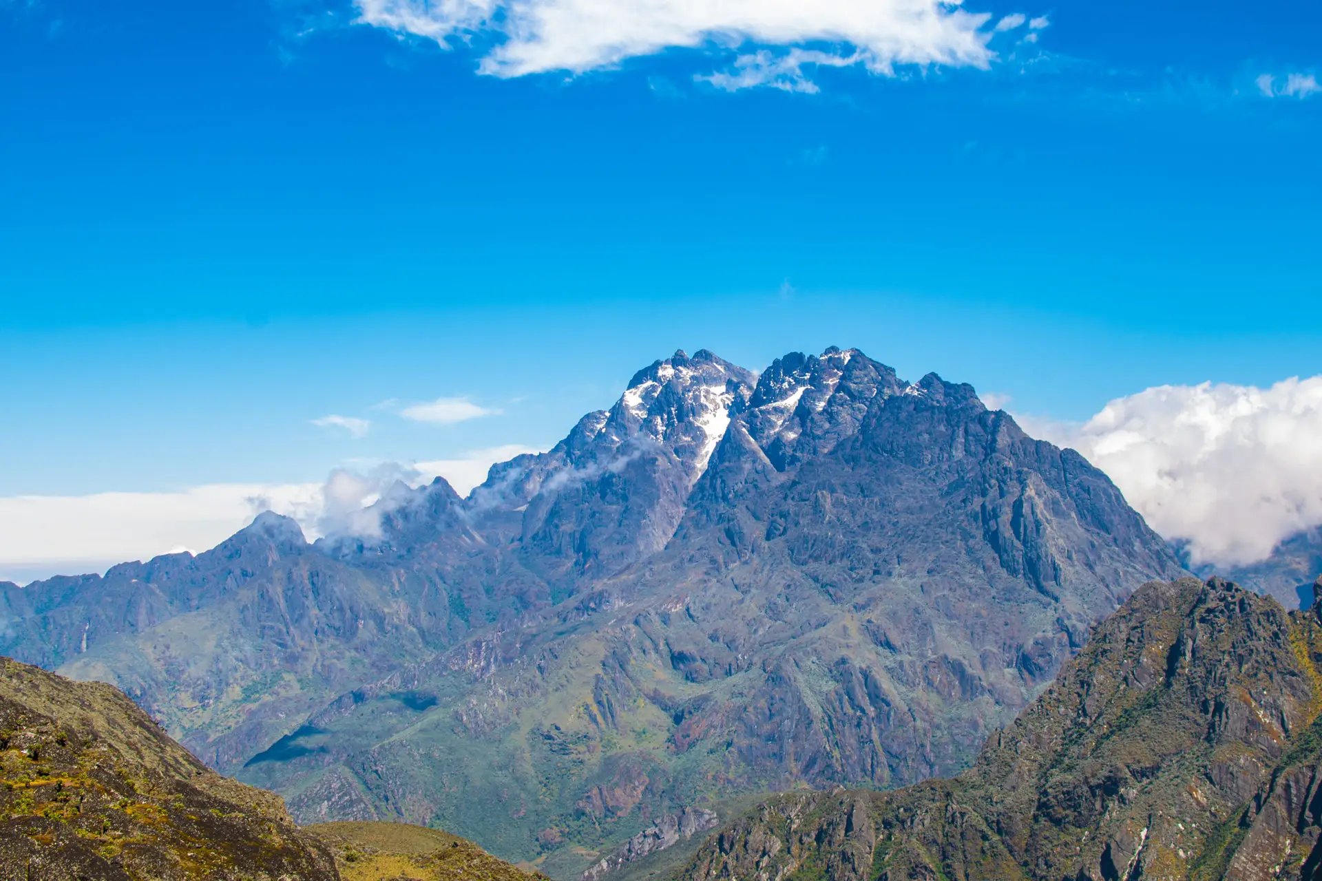
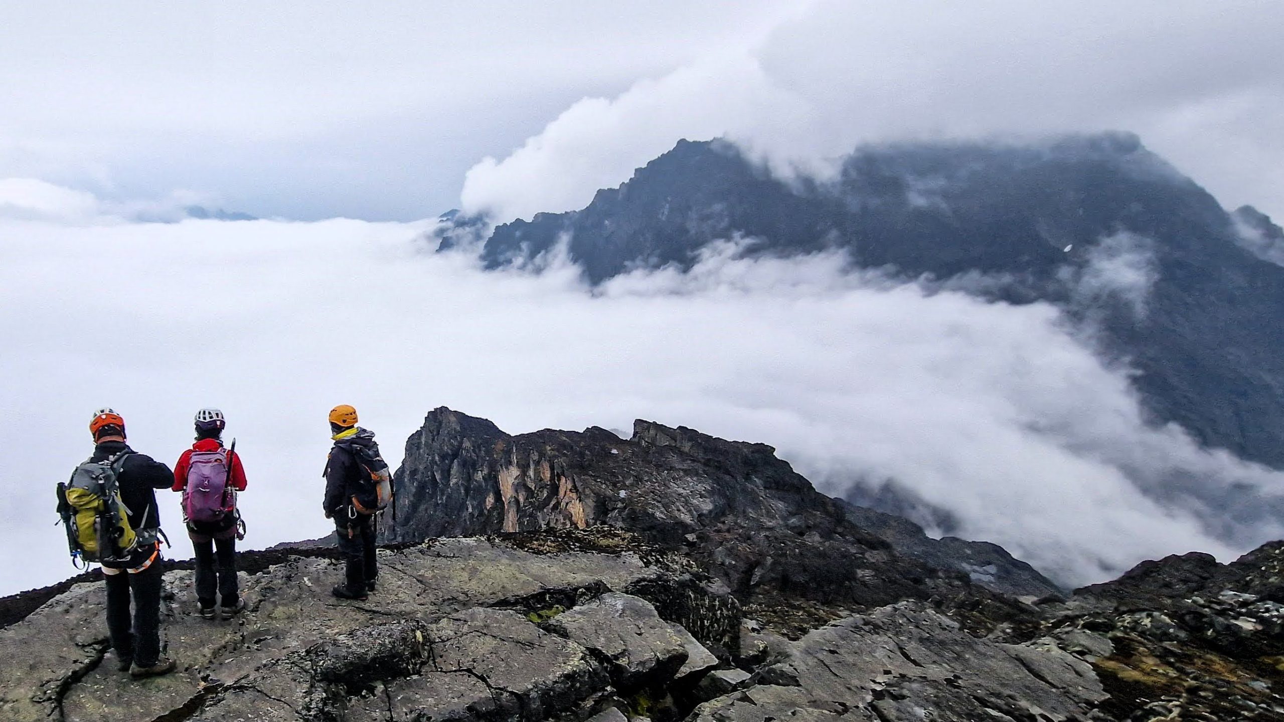
Bamwanjara Pass is a narrow saddle between two ridges of the Rwenzori’s inner rock core. A small emergency shelter hut sits at the pass, a useful windbreak in adverse conditions. In favourable conditions, the pass is one of the best viewpoints in the entire mountain range. To the west, you look back down the terrain you have climbed since Kilembe; to the east and north, the inner Rwenzori opens up. Mount Stanley dominates the horizon at 5,109 m, its glaciers visible as white bands above the dark rock; Mount Baker (4,843 m) rises to the south. Weismann’s Peak itself is now immediately ahead, its characteristic blade profile unmistakable.
Descent to Hunwick’s Camp via the Alpine Bogs
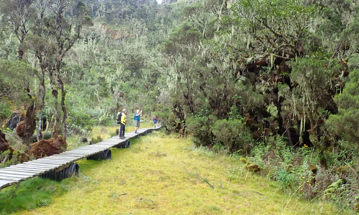
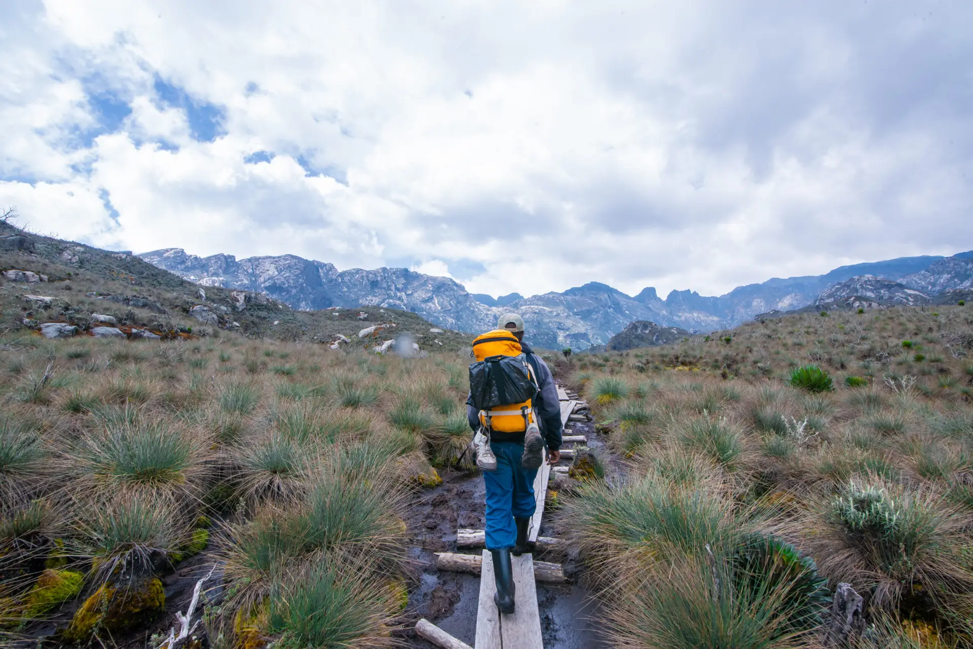
From Bamwanjara Pass, the trail descends into the inner Rwenzori valleys, skirting the edges of high-altitude alpine bogs where the Malachite Sunbird (Nectarinia johnstoni), a species endemic to the Rwenzori and Virunga highlands, breeds and feeds on the giant lobelia flower spikes. This is one of the most reliable spots on the entire Kilembe Trail to observe this jewel-green bird at close range; approach the lobelia stands quietly and watch the sunbirds work the flowers. The bog sections here require careful footing: stay on the established trail lines to avoid sinking in peat.
Hunwick’s Camp (3,974 m) sits on the rim of a deep valley with a 270-degree view of the surrounding mountain landscape; some trekkers describe it as the most dramatically positioned camp in the Rwenzori. The hut sleeps 12–16 in bunk platforms with a separate kitchen shelter. Night temperatures here can reach -2°C to -5°C; every layer you packed earns its place at Hunwick’s. Dinner is a full hot meal; be in bed early. Tomorrow begins before dawn.
Day 4 Highlights
- Bamwanjara Pass (4,450 m), the highest point of the approach, with panoramic views of Stanley, Baker, and Weismann’s Peak
- Emergency shelter hut at the pass a useful landmark and windbreak
- Malachite Sunbird sightings at the alpine lobelia bogs below the pass
- Descent into the inner Rwenzori valleys past giant lobelia and bog ecosystems
- Hunwick’s Camp (3,974 m) dramatically positioned on the valley rim with 270-degree mountain views
DAY 5: WEISMANN'S PEAK SUMMIT → KIHARO CAMP (3,974 m → 4,620 m → 3,460 m) | ~13 km
Hiking time: 9–12 hours total | Summit gain: +646m from Hunwick’s | Descent to Kiharo: −1,160 m | Overnight: Kiharo Camp (3,460 m)
Summit Morning: Approaching Weismann’s Peak
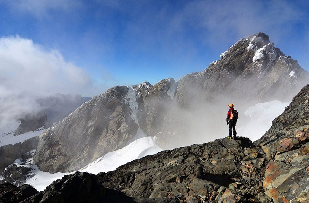
Your guide wakes the group at 5:00 AM. The predawn air at Hunwick’s Camp (3,974 m) is cold and still, with temperatures typically sitting between -3°C and -6°C before sunrise. Dress in all your layers before stepping out: thermal base, fleece, insulated jacket, waterproof shell, warm hat, and gloves. A hot drink and biscuits are enjoyed before departure, and then by 5:30–6:00 AM, the summit attempt begins in the beam of headlamps.

Weismann’s Peak (4,620 m) is one of the twin summits of Mount Luigi di Savoia, the other being Sella Peak (4,627 m). The ascent from Hunwick’s Camp climbs via McConnell’s Prong, a rocky ridge that provides the most direct line to the summit. The terrain is steep and rocky and requires sure-footedness but no technical roping or glacier travel. This is a high-altitude trekking peak, not a technical mountaineering objective. Altitude is the primary challenge: at 4,500 m+, you will feel the thin air on every step. The guide’s slow, rhythmic, deliberate pace is your best tool.
The Summit: Weismann’s Peak (4,620m)
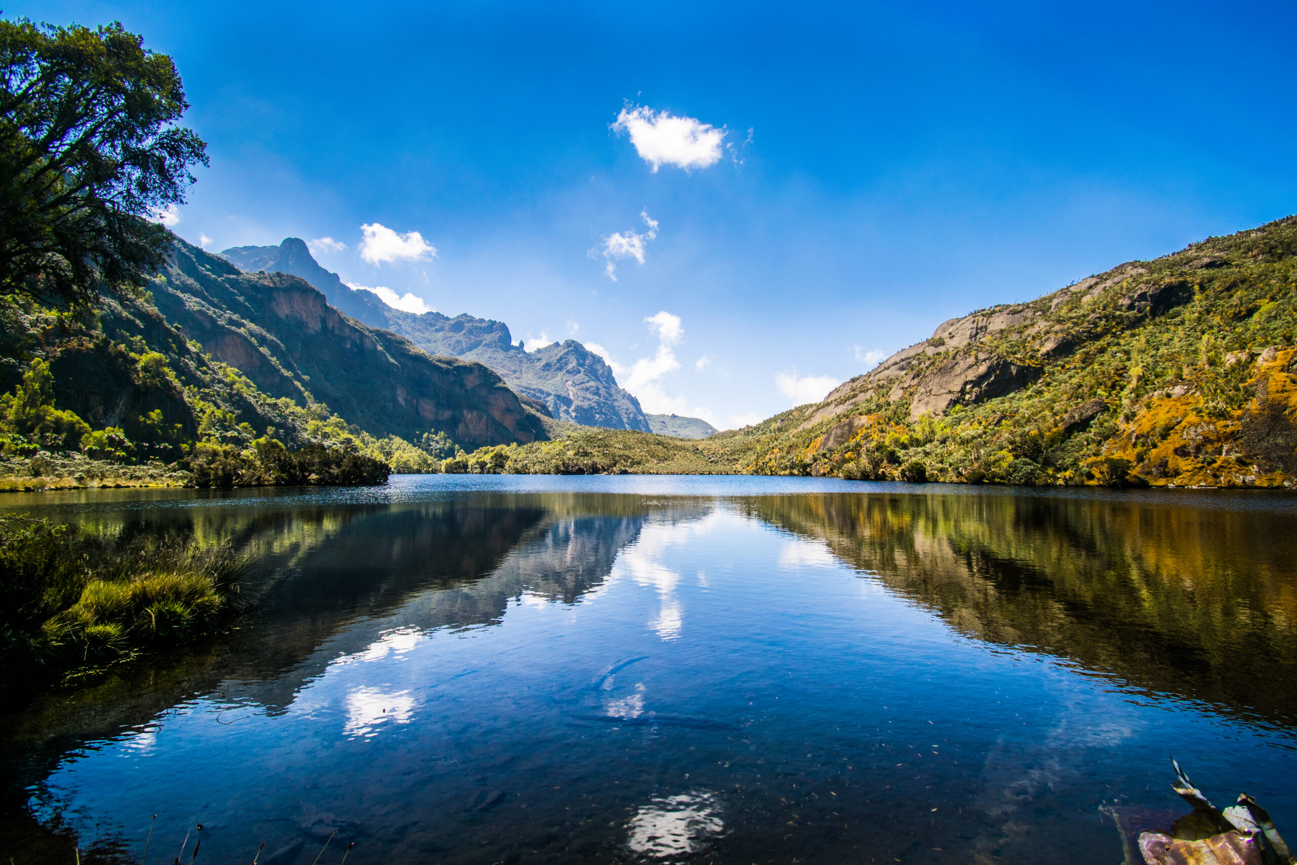
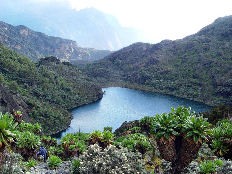
The summit of Weismann’s Peak is a narrow rocky crest with exposure on all sides. The view from the top is among the finest in the Rwenzori range: to the northwest, Margherita Peak (5,109 m) on Mount Stanley sits unmistakably above the clouds; to the south, Mount Baker’s Edward Peak (4,843 m) and the glaciated ridges of Freshfield Pass are spread before you; below, the Kitandara Lakes basin, a legendary glacially carved valley, shimmers in the morning light. On exceptionally clear mornings, the outline of the Virunga volcanoes is visible far to the southwest across the DRC border.
The summit is not a place to linger; cold, wind, and the demands of the day’s descent mean 20–40 minutes at the top. Photographs, a moment of justified pride, and then the descent begins. Weismann’s Peak at 4,620m is the 11th highest summit in all of Uganda; for most trekkers who stand here, it is the highest they have ever been in their lives.
Descent Through the Kitandara Valley to Kiharo Camp
From the summit, the descent route goes down into the upper Nyamwamba Valley via the Kitandara basin, one of the most visually spectacular alpine valleys in the Rwenzori Mountains. The Kitandara Lakes (also accessible on the Central Circuit Trail) sit in a glacially carved bowl at approximately 4,023 m, their dark water perfectly still when the air is calm. Giant groundsels and lobelias crowd the lake margins; glacier-scraped rock walls rise on three sides. Trekkers who have done both the Kilembe Trail and the Central Circuit routinely cite the Kitandara basin as the single most beautiful valley in the Rwenzori Mountains.
The route continues down through glacial moraines, old rockfall debris, and high alpine bog into the upper Nyamwamba Valley, where the landscape softens and Rwenzori red forest duikers are more often seen at the edges of the vegetation. Rock hyraxes call from boulder fields as the light fades. Kiharo Camp (3,460 m) is nestled in dense evergreen vegetation beside a rushing stream, its sheltered position a welcome contrast to the exposure of Hunwick’s. By the time you arrive, the summit is already several hours and over 1,000m of altitude behind you. It will take a few minutes to process everything that happened today.
Day 5 Highlights
- Pre-dawn summit departure from Hunwick’s Camp
- Ascent of Weismann’s Peak (4,620m) via McConnell’s Prong Uganda’s 11th highest summit
- 360-degree panorama: Stanley, Baker, Margherita, and the DRC on clear days
- Kitandara Lakes basin, arguably the most beautiful alpine valley in the Rwenzori
- Descent through glacial moraine and high alpine bog into the upper Nyamwamba Valley
- Overnight at Kiharo Camp (3,460 m), sheltered, forested, beside a mountain stream
DAY 6: KIHARO CAMP → NYAMWAMBA VALLEY EXIT → BASECAMP (3,460m → 1,480m) | ~18 km
Hiking time: 8–9 hours | Elevation loss: −1,980m | End of expedition
The Nyamwamba Valley Descent: A Grand Finale
Day 6 of the Weismann’s Peak expedition is a long, relentless descent and one of the most scenically rewarding final days of any Rwenzori trek. The Nyamwamba Valley gorge, carved by glacial meltwater over millennia, is a succession of waterfalls, moss-covered rock faces, deep forest gorges, and multiple river crossings that demand full attention even as the legs begin to tire. McConnell attempted this descent in 1937 and turned back; the technical obstacles were beyond what he could manage without the established path that now exists. Today, with a well-maintained trail and experienced guide, it is a formidable but navigable route.
The descent begins immediately steep from Kiharo Camp, dropping rapidly through the subalpine zone into the upper Afro-montane forest. Wildlife activity increases with every 100 m of lost altitude: Rwenzori red forest duikers move through the understory; rock hyraxes (Procavia capensis) colonize every boulder field; primate calls of colobus, L’Hoest’s, and occasionally the distant rumble of chimpanzees grow louder as the canopy closes overhead. A stop for lunch at Riverside Rock Shelter breaks the descent and allows the legs a rest before the final push to the valley exit.
Return to Basecamp
The Nyamwamba Valley exits through a final section of deep tropical forest before opening at the park boundary and the road connection back to Kasese. The expedition concludes at base camp, either at the Rwenzori Backpackers Hostel in Kilembe or with a vehicle waiting at the Nyamwamba exit point. The contrast between the world you have spent six days in and the world you return to is stark and disorienting in the best possible way.
This is the moment for photographs with your guide and porter team, for the tipping ceremony (see our Rwenzori tipping guide), and for the cold drink that has been somewhere in your thoughts since Bamwanjara Pass. Transfer to Kasese for accommodation, or onward to Fort Portal for post-trek recovery. The Rwenzori, as always, remains behind you, disappearing into its own cloud.
Day 6 Highlights
- The Nyamwamba Valley gorge waterfalls, moss-covered rock, and deep forest
- McConnell’s historic 1937 route now a carefully established trekking descent
- Increasing wildlife: duikers, hyraxes, primates, and rich birdlife at lower altitude
- Lunch at Riverside Rock Shelter
- Expedition conclusion at the Nyamwamba Valley exit: farewell to guides and porters
Elevation Profile: 6-Day Weismann’s Peak Expedition
The elevation arc of this 6-day Kilembe Trail expedition is aggressive on the ascent and dramatic on the descent, and critically, it is a point-to-point traverse rather than an out-and-back loop. You gain 1,146 m on Day 1 alone (trailhead 1,450 m to Sine Camp 2,596 m), which is one of the highest single-day gains on any Rwenzori itinerary. Day 2 adds 992m to Mutinda Camp (3,588m). Day 3 adds a further 512 m to Bugata Camp (4,100 m). Day 4 climbs 350m to Bamwanjara Pass (4,450m) before descending 476m to Hunwick’s Camp (3,974m). Day 5 pushes the final 646m to the summit (4,620m) before a 1,160m descent to Kiharo Camp (3,460m). Day 6 descends the remaining 1,980m through the Nyamwamba Valley to the exit.
The total cumulative ascent across the six days is approximately 3,170 m, comparable to the full ascent profile of the 7-day Margherita Peak Central Circuit. What makes this route distinctive is that the ascent is front-loaded: three of the largest gain days come in days 1–3, meaning your body must adapt quickly. The acclimatization hike to Mutinda Lookout on the afternoon of Day 2 is the critical buffer that makes this ascent profile manageable.
| Day 1 Start | Kilembe Trailhead: ~1,450 m |
| Day 1 End | Sine Camp: 2,596 m (+1,146 m) |
| Day 2 End | Mutinda Camp: 3,588 m (+992 m) |
| Day 2 Optional High | Mutinda Lookout: 3,975 m (+387 m from camp, return) |
| Day 3 End | Bugata Camp: 4,100 m (+512 m) |
| Day 4 High Point | Bamwanjara Pass: 4,450 m (+350 m from Bugata) |
| Day 4 End | Hunwick’s Camp: 3,974 m (−476 m from pass) |
| Day 5 Summit | Weismann’s Peak: 4,620 m (+646 m from Hunwick’s) |
| Day 5 End | Kiharo Camp: 3,460 m (−1,160 m from summit) |
| Day 6 End | Nyamwamba Valley Exit: ~1,480 m (−1,980 m) |
| Total Ascent | ~3,170 m cumulative |
| Total Descent | ~3,170 m cumulative |
| Route Type | Point-to-point traverse (different start and finish points) |
Mountain Camps & Accommodation on the 6-Day Weismann’s Peak Route
Sine Camp 2,596m (Day 1 Overnight)
Sine Camp sits at 2,596m in a sheltered clearing at the transition between upper bamboo and lower tree heather. It is the standard first overnight camp on all Kilembe Trail itineraries and a well-maintained facility with sleeping hut platforms, a separate kitchen shelter, and basic toilet facilities. Night temperatures of 10–14°C make it the warmest camp on this route. The stream adjacent to camp provides washing water. A short walk from Sine Camp leads to viewpoints over the Nyamwamba Valley below.
Mutinda Camp, 3,588 m (Day 2 Overnight)
Mutinda Camp occupies a wide, flat bowl beside a mountain stream at 3,588 m, framed by tree heather and the first alpine plants. The sleeping hut accommodates 12–16 trekkers on bunk platforms, with a kitchen and dining shelter separate from sleeping quarters. This camp requires warmer layers with night temperatures of 4–8°C. The optional afternoon acclimatization hike to Mutinda Lookout (3,975 m) departs from here and is one of the most recommended activities on the entire route.
Bugata Camp 4,100m (Day 3 Overnight)
Bugata Camp is the best-equipped high camp on the Kilembe Trail, with solar-lit sleeping huts, warm shower facilities (cold by lowland standards but remarkable at 4,100 m), a kitchen and dining shelter, composting toilets, and emergency helicopter landing access. It is the last camp before the Bamwanjara Pass crossing and the inner Rwenzori. Bugata offers some of the most compelling views on the route, including vistas across Lake Kopello and directly up to Weismann’s Peak. Night temperatures at Bugata: typically 0–4°C; a proper sleeping bag rated to 0°C is essential.
Hunwick’s Camp 3,974m (Day 4 Overnight)
Hunwick’s Camp, perched on the rim of a deep inner valley at 3,974m, offers a 270-degree view of the surrounding central Rwenzori massifs. It is the summit staging camp, your last sleep before Weismann’s Peak. Sleeping platforms for 12–16 people, a kitchen shelter, and basic toilet facilities are provided. Night temperatures here are consistently below 0°C; sleeping bags rated to -5°C are recommended. The dramatic exposure of this camp, open on three sides to the high mountain landscape, makes it one of the most memorable overnight locations in Rwenzori trekking.
Kiharo Camp, 3,460 m (Day 5 Overnight)
Kiharo Camp, nestled in dense evergreen vegetation at 3,460 m in the upper Nyamwamba Valley, is the post-summit overnight stay in a more sheltered, forested environment than Hunwick’s, with the sounds of a rushing stream replacing the exposed mountain wind. The contrast with the summit day environment is welcome. Rock hyraxes call from surrounding boulders at dusk. Sleeping hut platforms for 12–16 people, a kitchen shelter, and basic facilities are provided. Night temperatures: 4–8°C. Most trekkers sleep better here than at any of the higher camps.
Flora & Wildlife: What You’ll Encounter on the Kilembe Trail
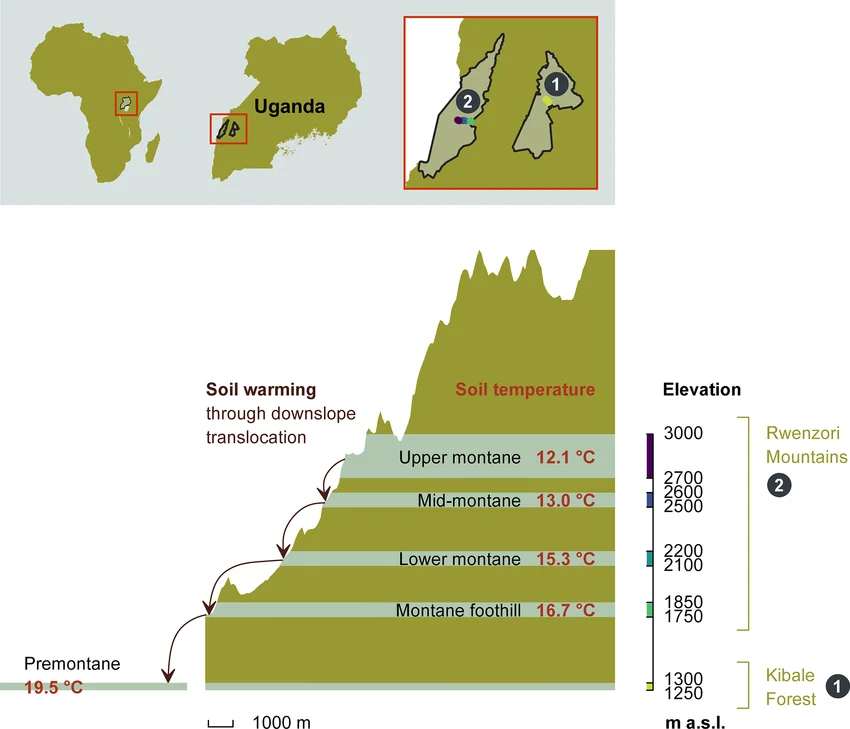
The Rwenzori Mountains are a UNESCO World Heritage Site partly because of their extraordinary biological diversity: five distinct vegetation zones stacked between 1,400 m and 5,109 m. The Kilembe Trail traverses all five on the ascent, and the descent through the Nyamwamba Valley adds a sixth dimension: the dramatic return through forest and gorge terrain at lower altitudes.
Afro-Montane Forest (1,400–2,500m) Days 1 & 6
The lower Nyamwamba Valley forest is among the richest wildlife environments on the Kilembe Trail. Black-and-white colobus monkeys (Colobus guereza) move through the upper canopy, and blue monkeys (Cercopithecus mitis) feed in the mid-canopy. L’Hoest’s monkeys (Allochrocebus lhoesti), endemic to the Albertine Rift region, are found in family groups in the understory. Chimpanzee vocalizations are sometimes audible from adjacent forest fragments. Bird life includes Rwenzori turacos (Tauraco johnstoni), Rwenzori olive pigeons, and dozens of forest specialist species. Read the full Rwenzori wildlife guide for complete species listings.
Bamboo Zone (2,200–2,800m) Days 1–2
Mountain bamboo (Arundinaria alpina) forms a dense corridor above the mixed forest. The understory is rich in mosses and orchids. Three-horned chameleons (Trioceros johnstoni), a Rwenzori endemic, are most commonly spotted at bamboo level on branches at eye height. Approach slowly and scan carefully.
Heather-Rapanea Zone (2,800–3,500m) Days 2–3
Tree heather (Erica arborea and Erica trimera) draped in Usnea lichen (‘old man’s beard’) forms the most visually distinctive zone along the lower-to-middle Kilembe Trail. You can find the Rwenzori nightjar and several sunbird species here. The gnarled, lichen-covered heather in the morning mist is one of the most photographed environments on the trail.
Afro-Alpine Moorland (3,500–4,500m) Days 3–5
The Rwenzori’s most globally iconic ecological zone is giant lobelias (Lobelia wollastonii and Lobelia bequaertii), which reach 4–5 metres; giant groundsels (Senecio adnivalis) form architectural stands; and everlasting flowers (Helichrysum stuhlmannii) carpet open ground. The Malachite Sunbird (Nectarinia johnstoni), a brilliant green species endemic to the Rwenzori and Virunga highlands, breeds and feeds on lobelia flower spikes and is one of the signature bird sightings at this elevation. Campers often see the Rwenzori Red Forest Duiker (Cephalophus nigrifrons rubidus), an endemic subspecies, around camp margins and in valley vegetation. Read the detailed vegetation zones guide for the complete botanical breakdown.
Nival/Summit Zone (4,500 m+) Day 5
Above 4,500 m, vegetation effectively ceases. The summit environment of Weismann’s Peak is bare rock, with occasional lichen colonies on sheltered faces. Birdwatchers sometimes see ravens and augur buzzards (Buteo rufofuscus) soaring above the summit ridge. The glaciers of Mount Stanley are visible from the summit on clear days; these are among Africa’s last equatorial glaciers, retreating at a documented and accelerating rate.
Physical Difficulty & Fitness Requirements
The 6-day Weismann’s Peak Kilembe Trail expedition sits firmly in the Hard category and should not be underestimated. It is not a technical mountaineering route no glacier travel, no ropes, no crampons but it is a genuinely demanding multi-day mountain trek with significant elevation gain, challenging terrain, and sustained physical output over six consecutive days. Read our full Rwenzori trekking difficulty guide for the complete framework.
Who This Trek Is Suited For
- Experienced multi-day trekkers who have completed at least 3–4 trips of 3+ days in the previous 18 months
- Trekkers comfortable with 7–9 hours of daily hiking on steep, uneven, and often muddy terrain
- Anyone with prior experience above 3,500m who has managed altitude well
- People who are specifically fit for mountain movement hill repeats, loaded pack hiking, stair training
- Trekkers who want a remote, lower-traffic alternative to the Central Circuit see our Central Circuit vs Kilembe Trail comparison
Key Physical Challenges Specific to This Route
- Day 1 elevation gain of +1,146 m, the steepest single ascent day of any Rwenzori itinerary
- Day 4 total movement of 8.3 km over 7–9 hours with significant pass crossing at 4,450m
- Day 5 summit day from 3,974m to 4,620m summit, then 1,160m descent to Kiharo: 9–12 hours total
- Day 6: descent of 1,980m over 18km on rocky, rooted, wet trail the longest distance day
- Point-to-point logistics: different start and end route cannot be aborted to the same trailhead
Altitude Considerations
The maximum elevation on this trek is 4,620 m at Weismann’s Peak, significantly above the 4,000 m threshold where serious altitude illness becomes more common. The Bamwanjara Pass crossing on Day 4 reaches 4,450m even before the summit. Preparation for altitude management is essential.
Key altitude rules on this route: walk at the guide’s pace without exception; drink 3–4 liters of water per day; eat full meals regardless of appetite; and report any worsening symptoms immediately. The optional Mutinda Lookout acclimatization hike on Day 2 afternoon is your critical altitude buffer; do not skip it. Discuss acetazolamide (Diamox) prophylaxis with your physician before departure. Read the complete Rwenzori altitude acclimatization guide and our full Rwenzori medical guide before your trek.
Best Time to Trek to Weismann’s Peak via the Kilembe Trail
The Rwenzori Mountains receive precipitation year-round; they are one of the world’s wettest mountain ranges, which is precisely why they still host equatorial glaciers. ‘Best season’ means relatively drier, not dry. See our complete best time to visit the Rwenzori guide for a month-by-month analysis.
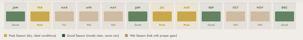
Primary Dry Window: January–February
January and February offer the most reliable weather window for the Kilembe Trail. The Bamwanjara Pass crossing and Weismann’s Peak summit are most stable in these months: firmer trail surfaces, less mist, and better summit visibility. This is the recommended peak season for this route.
Secondary Dry Window: June–August
June–August is the second reliable window. Conditions are generally drier than the wet season, though still variable. The Kilembe Trail’s steep sections drain faster than the Central Circuit bogs, making June–August a viable and often excellent period for this route. Early morning starts reduce exposure to afternoon cloud buildup.
Wet Season: March–May and September–December
Heavier rainfall, more persistent mist, and the most challenging bog and river conditions. The Kilembe Trail is technically passable year-round, but the point-to-point nature of this route (no easy bailout to the same trailhead) makes wet season planning more critical. We recommend only experienced trekkers with proper waterproof gear attempt this route outside the dry windows. Speak to our guides about current conditions before booking.
What’s Included in the 6-Day Weismann’s Peak Package
Included
- All Uganda Wildlife Authority (UWA) park entry fees and hut fees for 6 days
- Professional certified Kilembe Trail mountain guide (English-speaking)
- Assistant guide for groups of 4 or more
- Mountain chef and full catering: all meals from Day 1 lunch to Day 6 lunch
- One porter per trekker (carrying up to 15kg of communal gear and your personal pack)
- Accommodation in mountain huts: Sine, Mutinda, Bugata, Hunwick’s, and Kiharo camps
- Free loan of rubber boots (gumboots) for lower forest sections
- Sleeping mats in all huts
- First aid kit and emergency communication equipment
- Porter wages, meals, and accommodation throughout the trek
Not Included
- International flights and Uganda visa fees
- Pre- or post-trek accommodation in Kasese or Fort Portal
- Transfer to Kilembe Trailhead or from Nyamwamba Valley exit (can be arranged; ask us)
- Travel insurance comprehensive coverage, including altitudes up to 5,000 m+, is MANDATORY
- Tips for guides and porters (see tipping guide for recommended amounts)
- Personal trekking clothing, sleeping bag, and hiking boots
- Bottled water, soft drinks, or alcohol
- Any costs from itinerary changes due to weather, illness, or force majeure
⚠️ INSURANCE IS MANDATORY:
Bugata Camp (4,100 m) has helicopter access for emergencies, but evacuation costs without insurance are prohibitive. All trekkers must hold comprehensive travel insurance, including altitude coverage to 5,000 m+ and medical evacuation. No insurance = no departure.
Full Packing & Gear List: 6-Day Weismann’s Peak Trek
The Kilembe Trail presents the same foundational Rwenzori challenge as all routes on the mountain: sustained, total moisture. Add to the equation the specific demands of a point-to-point traverse, no opportunity to retrieve forgotten items from a starting trailhead, and the need for summit-level cold protection at Hunwick’s Camp. Pack carefully and pack completely. Study the full Rwenzori packing list and boot and footwear guide before departure.
Clothing Layering System
- Moisture-wicking thermal base layer (top and bottom): minimum 2 full sets
- Mid-layer fleece or lightweight down jacket
- Heavy insulated jacket (down or synthetic) essential for Hunwick’s Camp (below 0°C)
- Waterproof shell jacket (Gore-Tex or equivalent) non-negotiable on the Kilembe Trail
- Waterproof shell trousers
- Knee-length gaiters to keep mud out of boots on steep, wet ascents
- 2 pairs of quick-drying trekking trousers
- Warm beanie and balaclava (for Bamwanjara Pass and summit morning)
- Inner liner gloves and waterproof outer gloves
- Minimum 4 pairs of wool or synthetic trekking socks
Footwear

Rubber gumboots (Bogs, Dunlop, or equivalent provided free of charge) are essential for the lower forest and bog sections of Days 1 and 2. Waterproof hiking boots with excellent ankle support are required for Days 3–6, including the summit day. No crampons or technical footwear is needed. Weismann’s Peak is a trekking summit, not a glaciated technical climb. The complete Rwenzori footwear guide covers the rubber boot sizing and boot selection in full detail.
Equipment
- Two telescopic trekking poles used constantly on this route, especially on the descent
- Headlamp with fresh batteries and two spare sets (summit starts in darkness)
- Sleeping bag rated to -5°C (comfort rating Hunwick’s Camp regularly drops below 0°C)
- Sleeping bag liner for additional warmth at higher camps
- Waterproof dry bags to protect all electronics and clothing inside your main pack
- Main pack (40–50 L) for porter-carried items
- Summit daypack (20–25L) for personal items, water, snacks, and summit layers
- Water bottles or hydration bladders with a minimum 2-liter capacity
- Water purification tablets as backup
- UV-protective sunglasses (intense at 4,000–4,600m elevation)
- High-SPF sun cream and SPF lip balm
Health & Personal Items
- Personal prescription medications and any altitude medication (discuss with doctor pre-departure)
- Personal first aid: ibuprofen, paracetamol, blister plasters, antiseptic cream, rehydration salts
- Foot care: moleskin, blister prevention balm (constant moisture on Kilembe = high blister risk)
- High-energy summit snacks: energy bars, nuts, chocolate, dried fruit
- Electrolyte sachets critical for altitude hydration management
- Camera and multiple power banks (no charging on mountain for 6 days)
- Quick-dry travel towel
- Cash (USD) for tipping at trek conclusion
Permits, Park Fees & Cost Breakdown
All trekking in Rwenzori Mountains National Park operates under Uganda Wildlife Authority (UWA) regulations. Permits are mandatory and non-transferable and must be arranged through a licensed operator. Our full Rwenzori cost breakdown for 2026 provides detailed fee schedules for all route options.
| UWA Park Entry | USD $40 per person per day × 6 days = USD $240 (included in package) |
| UWA Hut Fees | Included in our package price for all 5 nights |
| Professional Guide | Included certified UWA and Kilembe Trail specialist |
| Porters | Included one per trekker at standard UWA rates |
| All Mountain Meals | Included: Day 1 lunch through Day 6 lunch |
| Rubber Boot Loan | Included free of charge |
| Sleeping Mats | Included in all huts |
| Glacier/Tech Gear | NOT required. Weismann’s Peak is a non-technical trekking summit |
| Gratuities | NOT included; see our tipping guide for recommended amounts |
| Pre/Post Hotel | NOT included; arrange separately in Kasese or Fort Portal |
Contact us directly for the current per-person price for the 6-day Weismann’s Peak expedition. Prices vary by group size and season. For comparison, the 4-day Mutinda Lookout trek (Kilembe Trail) starts at USD $645 per person. The 8-day Kilembe Trail to Margherita Peak is priced at USD $1,705 per person. The 7-day Baker & Weismann Trek adds an extra summit day. Ask us for a comparison across all Kilembe Trail options.
Getting to the Kilembe Trailhead
The 6-day Weismann’s Peak expedition begins at the Rwenzori Backpackers Hostel (Trekkers Hostel Kilembe) in Kyanjuki, approximately 35 km from Kasese town (35–45 minutes by road), unlike Central Circuit treks that start from Nyakalengija. Note that the itinerary is a point-to-point trek: you exit via the Nyamwamba Valley, not Kilembe. A vehicle transfer from the exit point back to Kasese or your accommodation should be pre-arranged.
From Kampala (approximately 5–6 hours)
Daily bus services run from Kampala (Kisenyi bus park) to Kasese companies, including Link Bus and Gateway Bus, a 5–6 hour journey time. We arrange a 35–45 minute vehicle transfer from Kasese to the Kilembe trailhead, either through us or via local taxi. Private vehicle transfer from Kampala is available through us at your preferred departure time.
From Entebbe International Airport
Entebbe (EBB) to Kasese is approximately 5.5–6.5 hours by road. Charter flight options to Kasese Airport (KSE) are available for groups. Ask us about current availability to save travel time. From Kasese, vehicle transfer to Kilembe is the final leg.
Pre-Trek Accommodation at Kilembe
The Rwenzori Backpackers Hostel at Kilembe (the trek’s starting point) provides overnight accommodation immediately at the trailhead, the most convenient option for a same-morning departure. Alternatively, Kasese town accommodation is available for trekkers who prefer a hotel the night before. After the trek, the Nyamwamba Valley exit point requires a vehicle transfer back to Kasese; we coordinate the transfer. Fort Portal (40km north) is the preferred post-trek recovery base for most trekkers continuing their Uganda itinerary.
Book Your Slot
Respond within Minutes
From
$1,200
per person
- Duration 6 Days / 5 Nights
- Group Size 1–12 people
- Start Point Kilembe TrailHead
- Departures Year-round
- Summits Weismann's Peak
No booking fee. Free cancellation up to 30 days before departure. We respond within Minutes.
Explore Related Kilembe Trail & Rwenzori Expeditions
Looking for more Kilembe Trail options or want to extend your Rwenzori adventure?
Magheritah Peak Summit (8 Days Kilembe Trail)
$1705 Per Person
The full Kilembe Trail to Africa's 3rd highest summit
The full Kilembe Trail to Africa's 3rd highest summit
Mutinda LookOut (4 Days)
$645 Per Person
Reach Mutinda Lookout (3,975m) and the first alpine views
Reach Mutinda Lookout (3,975m) and the first alpine views
7-Day Baker & Weismann Peak Trek
$1600 Per Person
Add Edward Peak (4,843m) on Mount Baker to your Weismann's summit
Add Edward Peak (4,843m) on Mount Baker to your Weismann's summit
10-Day 4-Peaks Trek: Margherita, Speke, Weismann & Baker
$2,000 Per Person
The premier multi-summit Rwenzori expedition
The premier multi-summit Rwenzori expedition
Frequently Asked Questions: 6-Day Rwenzori Weismann’s Peak Trek via Kilembe Trail
What is Weismann's Peak and how high is it?
Weismann’s Peak (4,620 m) is one of the twin summits of Mount Luigi di Savoia, the sixth-ranked of the Rwenzori Mountains’ six major massifs. The other summit is Sella Peak (4,627 m). Mount Luigi di Savoia is named after Prince Luigi Amedeo, the Duke of Abruzzi, who led the first major scientific expedition to the Rwenzori in 1906. Weismann’s Peak is the 11th highest summit in Uganda and is approached via the Kilembe Trail over this 6-day itinerary. It is a high-altitude trekking peak; no technical glacier equipment is required for the ascent. The summit offers panoramic views of Mount Stanley, Mount Baker, the Kitandara Lakes basin, and, on clear days, the Virunga volcanoes across the DRC border.
How does the 6-day Weismann's Peak trek differ from the 7-day Baker and Weismann Trek?
The 7-day Rwenzori Baker and Weismann Trek adds an additional summit to this itinerary, specifically Edward Peak on Mount Baker (4,843 m) by including an extra day for a detour from Freshfield Pass. The route structure is otherwise similar. If you have the time and fitness for a seventh day, the 7-day option delivers two named Rwenzori summits (Weismann’s Peak and Edward Peak) in a single expedition, significantly increasing the value and achievement of the trip. The 6-day version focuses exclusively on Weismann’s Peak and the Kilembe Trail traverse.
Is the Kilembe Trail harder than the Central Circuit?
Yes, the Kilembe Trail is generally considered harder than the Central Circuit for several reasons. The ascent profile on the Kilembe Trail is steeper and more front-loaded; you gain 1,146 m on Day 1 alone, which is more than the entire elevation gain of a typical 7-day Central Circuit Day 1. The terrain is more remote and more exposed, with fewer waypoints, less infrastructure, and a point-to-point structure that does not allow a straightforward bailout to the starting trailhead. The Central Circuit is the better choice for first-time Rwenzori trekkers; the Kilembe Trail, including the Weismann’s Peak route, suits experienced multi-day mountain trekkers who want a rawer, less trafficked experience. Our Central Circuit vs. Kilembe Trail comparison covers the differences in full detail.
Do I need technical climbing equipment for Weismann's Peak?
No. Weismann’s Peak is a high-altitude trekking summit, not a technical mountaineering objective. The ascent via McConnell’s Prong involves steep, rocky terrain requiring sure-footedness and excellent physical condition, but no glacier travel, no ropes, no crampons, and no ice axes. All summit equipment provided in our package is for trekking use only. The summit is accessible to any well-conditioned, altitude-experienced trekker who can manage sustained steep hiking on rocky ground. This distinguishes Weismann’s Peak from Margherita Peak (5,109m), which does require glacier equipment and fixed-rope sections.
What altitude does this trek reach and is there a serious altitude risk?
The maximum elevation on this 6-day expedition is 4,620m at the summit of Weismann’s Peak. The Bamwanjara Pass crossing on Day 4 reaches 4,450m. Both of these elevations are above the 4,000 m threshold where serious altitude illness, specifically Acute Mountain Sickness (AMS), High-Altitude Cerebral Edema (HACE), and High-Altitude Pulmonary Edema (HAPE), becomes increasingly common. The optional Mutinda Lookout acclimatization hike on Day 2 afternoon is the critical built-in altitude buffer on this itinerary. Our guides are trained in altitude illness recognition and carry emergency communication equipment at all times. Discuss acetazolamide (Diamox) prophylaxis with your physician before departure, and ensure your travel insurance covers medical evacuation from 5,000 m+ altitude.
What makes Bugata Camp special compared to other Rwenzori mountain camps?
Bugata Camp (4,100 m) is exceptional in the Rwenzori Mountains context because it combines high-altitude positioning with significantly better infrastructure than most mountain camps. Unique features include solar lighting in the sleeping huts, warm shower facilities (cold by lowland standards but remarkable at 4,100 m), and emergency helicopter access, making it one of the few high camps in the range from which medical evacuation is feasible without a ground carry. From Bugata, the views of Lake Kopello below and Weismann’s Peak directly above are among the most visually compelling of the entire Kilembe Trail. It is also the last comfortable staging point before the Bamwanjara Pass crossing.
Can I see the Kitandara Lakes on the 6-day Weismann's Peak trek?
Yes, the Kitandara Lakes basin is part of the descent route on Day 5. After summiting Weismann’s Peak and beginning the descent, the route passes through the upper Kitandara Valley, one of the most beautiful alpine basins in the Rwenzori Mountains. The Kitandara Lakes sit at approximately 4,023m in a glacially carved bowl, their dark water reflecting the surrounding peaks and glacial rock walls. This section of the route is one of the highlights of the Day 5 experience and is consistently described by trekkers as a profound natural encounter, particularly after the physical intensity of the summit morning.
What is the Nyamwamba Valley descent on Day 6 like?
The Day 6 Nyamwamba Valley descent is one of the most dramatic final days in Rwenzori trekking. The route drops 1,980m over approximately 18km through a succession of cascading waterfalls, moss-covered rock gorges, and multiple river crossings that require careful footwork throughout. This is the same valley that geologist McConnell attempted to descend in 1937 and abandoned; the obstacles without a properly maintained trail were too severe. Today the trail is established and guided. As altitude drops, wildlife activity increases markedly; colobus monkeys return to the canopy, duikers move through the understory, and bird diversity increases rapidly. The day ends at an entirely different exit point from the trek’s starting trailhead, confirming the true traverse nature of this expedition.
Is this trek suitable for solo trekkers or does it require a group?
This trek is entirely bookable as a solo trekker; in fact, many experienced solo mountain travelers choose the Kilembe Trail specifically for its lower crowd levels compared to the Central Circuit. You will be assigned a private guide and porter team, and the experience will be fully personalized to your pace and preferences. Solo trekkers are required to have a guide (mandatory under UWA regulations) and at least one porter. We recommend solo trekkers honestly evaluate their high-altitude experience before choosing this route: the front-loaded elevation gain, remote nature of the trail, and point-to-point logistics make this a better fit for solo trekkers who have prior multi-day mountain experience.
What should I do for accommodation before and after the 6-day Weismann's Peak trek?
The night before the trek, we recommend staying at the Rwenzori Backpackers Hostel (Trekkers Hostel Kilembe) at the trailhead itself; it is the most convenient option, allows early morning departure, and is where you will meet your guide team for a briefing. Kasese town (35–45 minutes by road) has several hotel options for trekkers who prefer a hotel environment. After the trek, the Nyamwamba Valley exit point requires a vehicle transfer, which we pre-arrange back to Kasese or onward to Fort Portal. Fort Portal is our recommended post-trek base: 40km north of Kasese, with excellent lodges, good food, and proximity to Kibale Forest National Park (chimpanzee trekking) if you want to add a wildlife day to your Uganda itinerary.
How does the 6-day Weismann's Peak route fit into a longer Rwenzori multi-peak expedition?
Weismann’s Peak is one of six major summits in the Rwenzori Mountains, and the Kilembe Trail that leads to it connects naturally to the inner Rwenzori circuit used by longer multi-peak itineraries. Trekkers who want to extend beyond Weismann’s Peak can continue to Edward Peak (Mount Baker, 4,843 m) by adding a day; the 7-day Baker and Weismann trek covers this. The 10-day 4-Peaks Trek (Margherita, Speke, Weismann, and Baker) combines elements of both the Kilembe Trail and Central Circuit in a full multi-summit expedition. The ultimate Rwenzori challenge, the 13-day 6-Peaks Grand Expedition, includes Weismann’s Peak as one of six summits across the full range. If you are planning a multi-peak Rwenzori adventure, speak to our guides about the optimal expedition structure.
How This Route Compares to Other Kilembe Trail Options
| Route | 6-Day Weismann’s Peak | 7-Day Baker & Weismann | 8-Day Margherita (Kilembe) | 4-Day Mutinda |
| Max Elevation | 4,620m | 4,843m | 5,109m | 3,975m |
| Summits | Weismann’s Peak | Weismann + Edward Peak | Margherita Peak | No summit |
| Difficulty | Hard | Hard | Very Hard | Moderate |
| Tech Gear | No | No | Glacier kit | No |
| Route Type | Point-to-point | Point-to-point | Point-to-point | Out-and-back |
| Price Indicator | Contact us | Contact us | From $1,705 | From $645 |
For a full side-by-side analysis of all Kilembe Trail options, see the Rwenzori trekking routes overview and our dedicated Central Circuit vs Kilembe Trail comparison guide.
Ready to trek the Kilembe Trail to Weismann’s Peak?
The trek consists of six days, five camps, a pass at 4,450m, a summit at 4,620m, and a descent through one of the most dramatic valley gorges in Africa. The Kilembe Trail to Weismann’s Peak is the Rwenzori at its wildest and most rewarding. Few trekkers make it here. Those who do rarely forget it.
When You Contact Us:
✔ Speak with a guide who has completed the Kilembe Trail dozens of times ✔ Receive a transparent, itemised quote for your group size and dates ✔ Get honest advice on whether 6, 7, or 8 days suits your fitness and summit goals ✔ Confirm with a 30% deposit balance due before departure
📲 WhatsApp: +256 773 256 104 | 📧 rwenzoritrekkingsafaris@gmail.com