Can you hike the Rwenzori from the DRC Congo side? An expert guide covers Virunga’s safety, Ugandan routes, and how to plan your trek.
The Rwenzori Mountains straddle an international border, and that fact alone is responsible for one of the most persistent questions we receive from serious trekkers who have done their research: can you approach the mountains from the Democratic Republic of Congo? It is a perfectly reasonable thing to wonder. The Rwenzoris do not end at the Ugandan boundary post. Their western flanks descend into the DRC, into territory that forms part of Virunga National Park. Maps show the border running straight through the massif. And so the logic seems sound; if the mountains extend into both countries, surely both countries offer a way in?

The short, honest answer is as follows: while a DRC entry into the Rwenzoris is theoretically possible in geographical terms, it is not a realistic or recommended option for any international trekker planning an expedition today. The reasons are not abstract. They are specific, current, and serious. This article will explain exactly why, detail what the Congo-side approach actually involves, lay out the many practical advantages of approaching the mountains from Uganda, and give you everything you need to plan a safe, successful, and deeply rewarding Rwenzori trek.
We guide expeditions on these mountains professionally. We have walked every established trail on the Ugandan side, from the classic Central Circuit to the Kilembe Trail, and we monitor conditions across the broader Albertine Rift region closely. What follows reflects that firsthand knowledge.
The Geography: How the Rwenzori Straddles Two Countries
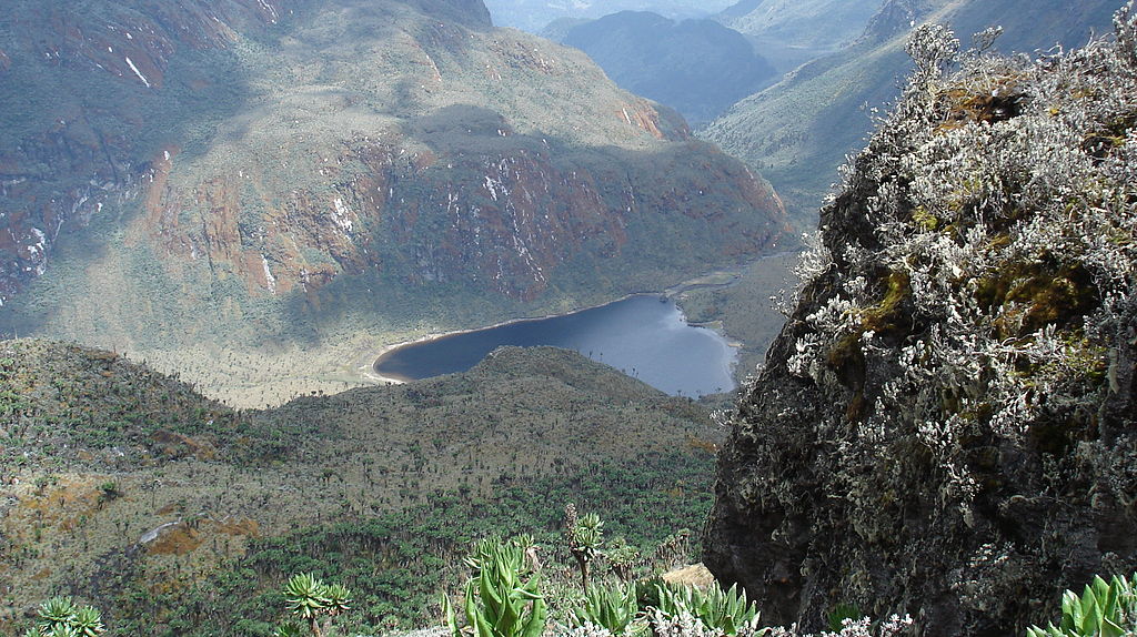
Before answering the access question, it helps to understand the geography clearly. The Rwenzori Mountains are a faultblock range that sits on the border between Uganda to the east and the Democratic Republic of Congo to the west, occupying roughly 120 kilometres of the Albertine Rift escarpment. The Ugandan portion falls within Rwenzori Mountains National Park, a UNESCO World Heritage Site managed by the Uganda Wildlife Authority. The western Congolese slopes of the range form the northeastern sector of Virunga National Park, Africa’s oldest national park and itself a UNESCO World Heritage Site.
The highest peaks, Mount Stanley with its crown, Margherita Peak at 5,109 meters, Mount Speke, Mount Baker, and a group of lesser giants, including Mount Emin, Mount Gessi, and Mount Luigi di Savoia, sit on or very near the international border ridge. Margherita Peak itself, Africa’s third-highest point, is effectively a summit that belongs to both nations simultaneously. From the very top, on a clear morning, you can look east across Uganda’s Bujuku Valley and west down into the Congo Basin. The mountains do not choose sides. The trekking infrastructure, however, very much does.
The DRC Side: What the Congo Approach Actually Involves
For a handful of decades in the mid-twentieth century, the Congolese side of the Rwenzoris did see some mountaineering activity, principally by expeditions based out of what was then Zaire. Explorers and climbers who made their way to the western foothills could find routes that ascended toward the central massif. The colonial-era infrastructure, thin as it always was, at least existed. That world is long gone.
The Congolese sector of the Rwenzoris today falls within the jurisdiction of Virunga National Park, specifically within its central zone bordering the Ugandan park. Virunga is administered by the Institut Congolais pour la Conservation de la Nature (ICCN), and it remains, as of 2026, one of the most conflict-affected protected areas on Earth. The park has been on UNESCO’s List of World Heritage in Danger for years, and the security situation in North Kivu Province within which the relevant sector lies has deteriorated sharply rather than improved.
⚠️ SECURITY WARNING: Eastern DRC: Current Situation (2026)In early 2025, the M23 armed group launched a major offensive across eastern DRC, capturing Goma and Bukavu, the primary logistics hubs for any approach to the Virunga sector. UNESCO and the United Nations Security Council both formally acknowledged this deterioration. By early 2026, Virunga National Park had lost operational control of its southern and central sectors entirely, with a strategic withdrawal to the north required to protect park staff. The park reported controlling only approximately 65% of its territory. Multiple armed groups, including the M23, the ADF, and numerous other militias, operate in and around the areas through which any DRC approach to the Rwenzori would need to pass. |
The practical consequence of all these factors is that there is no functioning, established trekking route into the Rwenzoris from the Congolese side. There are no maintained huts, no porter system, no ranger escort programme designed for summit trekkers, and no reliable means of emergency evacuation in the event of an accident or medical emergency at altitude. The infrastructure necessary for safe high-altitude trekking, including experienced guides who know the terrain intimately, fixed camps, supply chains, communication systems, and park authority oversight, does not exist in any form on the Congolese side of the Rwenzori to support a planned expedition.
Determination or effective planning cannot bridge this gap. Even seasoned mountaineers who have navigated genuinely remote ranges elsewhere in the world would face an impossible combination of obstacles on the DRC side: an active conflict zone, zero institutional support, no established route, and terrain that is inherently demanding even under ideal conditions. The Rwenzori is already considered a difficult mountain by the standards of African trekking. Attempting it through eastern DRC would add layers of danger that no experienced operator would sanction.
Why Is the Ugandan Side the Only Practical and Safe Choice?
Uganda’s approach to the Rwenzori Mountains is not simply the safer alternative to the DRC; it is the only established, supported, and logistically sound way to attempt these peaks. The reasons stack up on every dimension a serious trekker would care about.
A Mature, Professionally Managed National Park
Rwenzori Mountains National Park on the Ugandan side is a functioning, professionally administered protected area under the Uganda Wildlife Authority. A clear system handles entry, permits, guide assignments, hut bookings, and emergency protocols. The park has decades of accumulated operational experience with international trekkers. Rangers know every section of established trail. Emergency evacuation procedures including helicopter landing zones at key camps exist and are tested. This knowledge knowledge is the baseline that makes multi-day alpine trekking in a remote range responsible rather than reckless.
Three Distinct Trail Systems, Suited to Different Ambitions
The Ugandan side offers genuine route variety, something the DRC cannot offer at all. The Central Circuit Trail remains the classic route, a complete loop through the heart of the range that passes through all five major vegetation zones, traverses the high alpine at Scott Elliot Pass, and delivers trekkers to Elena Camp as the staging point for the Margherita Peak summit bid. Our 7-Day Central Circuit itinerary remains one of the most complete single-trek experiences available on any African mountain.
The Kilembe Trail, accessed from the copper-mining town of Kilembe near Kasese, offers an entirely different character, steeper and more physically demanding in places, but with a different set of views and a strong sense of discovery. The 8-Day Kilembe Trail to Margherita Peak is the route of choice for trekkers who want to push themselves and see sections of the range that the Central Circuit skirts. For those focused on a specific peak on the western massif, our 7-day Mount Baker and Weismann Peak trek via the Kilembe Trail covers terrain that few trekkers ever reach.
And for trekkers with more time and the ambition to stand on multiple summits, the Ugandan side scales impressively. Our 13-day Six Peaks Expedition linking the summits of Mount Stanley, Mount Speke, Mount Baker, Mount Emin, Mount Gessi, and Mount Luigi di Savoia represents one of the most ambitious multi-peak routes anywhere in Africa. For the genuinely committed mountaineer, the 18-Day All 8 Peaks Expedition exists as the ultimate Rwenzori challenge.
Established Hut and Camp Infrastructure
The Ugandan side of the Rwenzori has a network of maintained mountain huts that fundamentally changes the trekking experience in terms of safety and comfort. On the Central Circuit, trekkers move between Nyabitaba Hut, John Matte Hut, Bujuku Hut, Elena Camp, Kitandara Hut, and Guy Yeoman Hut. On the Kilembe Trail, the camp system runs through Kalalama, Mutinda, Bugata, Hunwicks, and Margherita camps. Each facility provides shelter, mattresses, and some degree of cooking infrastructure. Such accommodation matters enormously at altitude, especially on a mountain as persistently wet as the Rwenzori. Reliable shelter is not a comfort issue; it is a hypothermia-prevention issue. Our medical guide to trekking the Rwenzori covers in detail why cold and wet are the most underestimated hazards on this mountain.
Professional Guides and Porters with Specific Rwenzori Expertise
The guides we employ on the Ugandan side are not general mountain guides who have learned the Rwenzori trails from a manual. They are specialists who have grown up in the foothills of this range, who have walked these routes hundreds of times through every conceivable weather condition, and who understand the mountain’s specific hazards: the notorious bogs, the glacier approach from Elena, and the ice-axe sections above 4,800 meters with a depth that only comes from years of direct experience. When you book a trek with us, your guide knows what the cloud ceiling at Bujuku means for your summit morning because they have read that sky a thousand times.
Clear Permit and Entry Processes
Trekking the Rwenzori from Uganda requires a straightforward permit process through the Uganda Wildlife Authority, handled for you as part of your booked itinerary. The system is clear, the costs are transparent, our full cost breakdown for climbing the Rwenzori covers every line item, and there is no ambiguity about what permissions you need or who issues them. Uganda is politically stable, has a functional visa system (available online or on arrival at Entebbe International Airport), and maintains normal diplomatic relations with the international community. Currently, we cannot make any of these baseline assumptions about eastern DRC.
Who Is Actually Asking This Question?
The question of DRC access to Rwenzori tends to come from a specific kind of trekker: highly experienced, deeply research-oriented, drawn to less-traveled routes, and instinctively sceptical of the mainstream path. If that describes you, we want to acknowledge the spirit behind the question, even as we firmly direct you toward Uganda.
The impulse to approach from the Congo side often reflects a desire for genuine wilderness, for a route that feels unspoiled by trekking traffic, for something that goes beyond the established itineraries you find on every outdoor tourism website. That impulse is entirely valid. But here is what we can tell you from direct experience on these mountains: the Ugandan side of the Rwenzori already delivers that quality of experience. The Rwenzori is not Kilimanjaro. It is not even close to a crowded mountain. On many of our expeditions, particularly on the upper sections of the Kilembe Trail or the high traverse between Kitandara and Elena, we encounter no other trekking parties at all. The sense of isolation, the feeling of being genuinely deep in an extraordinary alpine world, is real and present on the Ugandan routes without the addition of armed-conflict risk.
For the trekker who wants to go beyond the standard itineraries, the right answer is not to attempt the DRC side; it is to go deeper into the Ugandan routes that most people never reach. A dedicated Mount Emin trek or a 7-day Mount Gessi expedition will take you to summits that see only a handful of expeditions per year. These are peaks that sit very near the Congolese border that look out directly over the western massif and the forests that descend toward the Congo Basin. You get the geographical proximity to that wild western flank and all the infrastructure and safety of the Ugandan side.
💡 Guide’s Insight: The Most Remote Ugandan RoutesTrekkers seeking genuine remoteness within the Ugandan Rwenzori have options that go far beyond the standard Central Circuit. The 5-Day Mount Speke Trek, the approach to Mount Gessi via the extended circuit, and the upper Nyamwamba Valley on the Kilembe side all deliver wilderness experiences that rival anything available on less-established ranges in East Africa with the critical advantage of an operational support system behind you. |
What About a Cross-Border Traverse?
A related question that occasionally arises among serious mountaineers is whether a full traverse entering from Uganda and exiting into the DRC, or vice versa, might be possible. This is a compelling idea conceptually. The ridge-top border means that standing on Margherita Peak, you are technically on the boundary. A descent of the western face would, in geography if not in practice, take you into Congolese territory.
From a safety and legal standpoint, such an approach is not a viable option. Crossing an international border on a remote mountain without a proper point of entry creates immediate legal complications on both sides. There is no Congolese border crossing point within the Rwenzori massif, no consulate or immigration facility, and no mechanism for entering the DRC legally via the mountain. Attempting to descend the western face into Congolese territory without proper border clearance would constitute an illegal entry into a country that is currently experiencing active armed conflict in the very region concerned. This is not an adventure; it is a serious legal and physical safety risk.

We are occasionally asked by trekkers who have already completed the Ugandan routes whether they might arrange a meeting at the summit with a Congolese party coming up the western face. While romantically appealing, such an arrangement would require a fully supported expedition operating simultaneously from the DRC side, and for the reasons already covered in detail, no such expedition infrastructure exists on that side of the range today.
Planning Your Rwenzori Trek from Uganda: Where to Begin
Having established clearly why Uganda is the approach, let us give you a practical orientation to the choices available from the Ugandan side. The starting point for almost all Rwenzori treks is the Kasese District in western Uganda, approximately 420 kilometres from Kampala along the highway that passes through Fort Portal. The park has two main trailheads: Nyakalengija, which serves the Central Circuit, and the Kilembe trailhead near the old copper mine, which serves the Kilembe Trail routes.
Choosing the Right Route for Your Goals
The single most important planning decision is route selection, and it depends almost entirely on what you want the trek to be. If your primary goal is to stand on Margherita Peak to reach Africa’s third-highest summit, then the Central Circuit route or the Kilembe Trail approach are your options, each with a distinct character. Our guide on the best route for trekking the Rwenzori Mountains lays this choice out in full. If your goal is a broader mountain experience that does not necessarily include a technical summit bid, routes like the Mahoma Loop or the 4-Day Mutinda Lookout trek via Kilembe offer exceptional experiences within a more accessible timeframe.
How Long Do You Need?
This topic is one of the most commonly asked questions, and the answer depends on your objective. A comfortable ascent of Margherita Peak via the Central Circuit requires a minimum of seven days; our full analysis of how many days it takes to reach Margherita explains why rushing this mountain is a poor strategy. Rwenzori is not a mountain where willpower compensates for insufficient acclimatisation time. The altitude gain is steep, the terrain is physically demanding in ways that few other mountains match, and the persistent cold and wet require that your body has genuinely adjusted before you make the final push. For a multi-peak expedition, expect to build your itinerary around at least 10 to 13 days of mountain time.
Is the Rwenzori Right for You?
The Rwenzori is not a beginner’s mountain, but it is also not exclusively the preserve of elite alpinists. Our piece on whether beginners can climb the Rwenzori Mountains draws an honest line between what is achievable for a determined, fit person with no technical climbing experience and what requires genuine mountaineering skill. The summit of Margherita Peak involves glacier travel and the use of crampons and ice axes. Our guide to the technical demands of the Margherita climb gives you a precise, unvarnished picture of what the upper mountain requires. Whether you need your own gear or can rely on equipment provided, our guide on climbing gear for a Rwenzori trek answers that specifically.
The non-summit routes, the lower Kilembe Trail days, the Mahoma Loop, and the approach hikes to mid-range camps are achievable for any reasonably fit person with proper preparation. The key physical requirement is sustained endurance rather than raw strength, combined with a tolerance for wet conditions and the mental steadiness that high-altitude environments demand. Our Rwenzori fitness guide gives you a realistic training framework and the right expectations.
The Rwenzori’s Unique Ecosystem: What You Will Encounter
One reason serious trekkers return to the Rwenzori often multiple times is the ecosystem. This is not a mountain you ascend through generic alpine scenery. The Rwenzori has a botanical character unlike any other mountain range in Africa or, arguably, the world. The giant heathers draped in old man’s beard lichen, the surreal groundsels and giant lobelias of the upper Afro-alpine zone, and the enormous moss-covered boulders of the lower rainforest, each zone is genuinely alien in its beauty. The wildlife of the Rwenzori Mountains includes endemic bird species found nowhere else on Earth, Rwenzori colobus monkeys, hyraxes, and the occasional leopard track across a high camp. The question of whether you might see snow on the Rwenzori at equatorial altitude and the related matter of the disappearing Rwenzori glaciers adds another dimension of scientific and environmental significance to every expedition.
What About the Future? Could the DRC Side Ever Become Viable?
This is a fair question to ask, and we want to answer it honestly rather than dismissing it. Yes, a western approach to the peaks could eventually develop if the security situation in the eastern DRC stabilises permanently and conservation and tourism authorities invest in trail infrastructure on the Congolese side of the Rwenzori. There is genuine geographical potential there; the western face of the range has its character, its own forest zones, and perspectives onto the peaks that are genuinely different from anything available on the Ugandan side.
But “in principle” and “conceivably” are doing a tremendous deal of work in that sentence. The security situation in North Kivu has been in various states of crisis for over three decades. The M23 offensive of 2025 represents not a temporary setback but a continuation of patterns that the United Nations Security Council formally acknowledged as a major deterioration and that have never resolved cleanly. Conservation organisations that have invested enormously in Virunga, including with significant international NGO funding, have repeatedly been unable to establish the durable security that would allow sustained tourism operations in the relevant sectors. The park itself, as of early 2026, had lost control of large portions of its territory.
We will say this clearly: if there ever comes a time when the Congolese side of the Rwenzori is safe, supported, and open to international trekking, it will likely be one of the most remarkable mountain experiences on Earth. The western descent toward the Congo Basin, through forests that have seen almost no trekking traffic in modern times, would be extraordinary. But that day, if it comes, is not today, and planning a trek on the assumption that conditions might improve before your departure date would be an unacceptable gamble with your safety.
Frequently Asked Questions: Hiking the Rwenzori from the DRC Congo Side
Can you hike the Rwenzori Mountains from the Congo DRC side?
Geographically, the Rwenzori Mountains do extend into the Democratic Republic of Congo, where their western slopes fall within Virunga National Park. In a strictly geographical sense, the answer is affirmative, as the mountains are present on the Congolese side of the border. However, as a practical matter for any international trekker planning an expedition in 2026, hiking the Rwenzori from the DRC side is not feasible, safe, or advisable. The eastern DRC, and North Kivu Province specifically, has been in a state of active armed conflict, with the M23 group’s major offensive in 2025 causing Virunga National Park to lose control of its southern and central sectors. There is no established trail system, no maintained mountain huts, no guide or porter infrastructure, and no emergency evacuation framework on the Congolese side of the Rwenzori. The only practical, safe, and supported entry to the Rwenzori Mountains is from Uganda, through Rwenzori Mountains National Park.
Is Virunga National Park safe to visit for trekking in 2026?
Virunga National Park in the DRC is classified as a UNESCO World Heritage Site in Danger, and as of early 2026, it remains one of the most conflict-affected protected areas in the world. The M23 armed group’s offensive in early 2025 significantly escalated violence in eastern DRC, affecting Goma and Bukavu, the main logistics cities for any Virunga visit. Park authorities have reported losing control of significant portions of the park, and multiple armed groups operate in and around the relevant sectors. While some limited gorilla trekking may have resumed in restricted, heavily guarded areas within the safer southern portions of Virunga under strict protocols, mountain trekking to the Rwenzori summits via the Congolese side is entirely unavailable. For any serious trekking objective in the Rwenzori range, Uganda is categorically the safer choice.
Are Mount Stanley and Margherita Peak accessible from the Congo side?
Mount Stanley and its summit, Margherita Peak, sit on the international border ridge between Uganda and the DRC. Both countries technically share the summit. However, all established routes to Margherita Peak approach from the Ugandan side, either via Elena Camp on the Central Circuit or via Margherita Camp on the Kilembe Trail. There has been no functioning western approach in the DRC in modern times, and current conditions in the eastern Congo make any such attempt impossible. Every summit expedition to Margherita Peak, Africa’s third-highest point, departs from the Ugandan side of the range.
What are the main trekking routes on the Ugandan side of the Rwenzori?
The Ugandan side of the Rwenzori offers three main trail systems, each with a distinct character. The Central Circuit Trail is the classic complete loop through the heart of the range, passing through all five vegetation zones and serving as the primary route to Margherita Peak via Elena Camp. It is typically done over seven to nine days. The Kilembe Trail approaches the mountain from the south, through the old copper mining area near Kasese, and provides a steeper, more demanding ascent with different views and a well-developed network of high camps. Multi-peak expeditions generally combine sections of both systems. The Bukulungu Trail and the Mahoma Loop offer excellent shorter trekking experiences in the lower and mid-altitude zones of the park, suitable for those who want a genuine Rwenzori experience without committing to the full summit push.
Do I need a visa to trek the Rwenzori from Uganda?
Yes, you will need a Uganda visa to trek the Rwenzori from the Ugandan side. Uganda’s visa system is well-established and straightforward for most international visitors. Visas can be applied for online through the Ugandan e-visa portal well in advance of travel or obtained on arrival at Entebbe International Airport, though an advanced online application is strongly recommended to avoid delays. East African Community citizens from Kenya, Rwanda, Burundi, Tanzania, and South Sudan have their own arrangements. Additionally, trekking in the national park requires Uganda Wildlife Authority park entry permits and registered guide fees, all of which are incorporated into packages booked through a licensed operator like us.
How difficult is the Rwenzori compared to other African mountains?
The Rwenzori is widely regarded as the most technically demanding and physically challenging of Africa’s major trekking mountains, significantly more so than Kilimanjaro and considerably more demanding than Mount Kenya’s non-technical routes. The difficulty is not primarily altitude: at 5,109 metres, Margherita Peak is lower than Kilimanjaro’s Uhuru Peak at 5,895 metres. The challenges come from the sustained nature of the terrain, which involves deep bogs, dense vegetation, slippery rocky sections, river crossings, and cold wet conditions that persist regardless of season. The final section of the Margherita summit requires glacier travel with crampons and ice axes, making it a genuine mountaineering objective rather than a pure trekking peak. The mountain has earned its reputation for difficulty, necessitating proper preparation, fitness, and acclimatisation.
What is the best time of year to hike the Rwenzori from Uganda?
The Rwenzori can be trekked year-round from Uganda, but conditions vary significantly with the seasons. The driest and most reliably clear periods fall between late December and mid-March and again from June through September. These months offer the best chances of clearer summit days, drier trails in the lower sections, and more stable weather on the high plateau. That said, the Rwenzori earns its reputation as one of the wettest mountain ranges in Africa; rainfall can occur in any month, and the famous Rwenzori bogs remain a feature of the trail system even in the dry season. No trekker should plan an expedition expecting dry boots or guaranteed clear skies. The mountain’s atmospheric unpredictability contributes to its character, and we prepare every expedition we guide for rain, regardless of the calendar.
Can I combine a Rwenzori trek with a gorilla trekking safari?
Combining a Rwenzori trek with gorilla trekking in Uganda is one of the most spectacular safari combinations available in East Africa, and it is something we actively help trekkers plan. You can access Uganda’s Bwindi Impenetrable Forest and Mgahinga Gorilla National Park, which both house significant populations of the endangered mountain gorilla, by driving through the Albertine Rift highlands from the Kasese area. Our 12-day Rwenzori and gorilla trek combination itinerary packages the full mountain experience with a gorilla tracking day, giving you the best of Uganda’s two most extraordinary wildlife encounters in a single trip.
🏔️ Ready to trek the Rwenzori Mountains? Start Here.The Rwenzori Mountains are one of the world’s great mountain ranges, and Uganda’s side of the border gives you everything you need to explore them properly: established routes, expert guides, mountain huts, and a national park system built for serious trekkers. Whether your goal is Margherita Peak, a multi-peak expedition across six summits, or a shorter immersive walk through the Afro-alpine zone, the Rwenzori Mountains from Uganda deliver an experience that few other mountains on Earth can match. Get in touch with our team today to start planning. We respond to every enquiry with specific, honest advice tailored to your fitness level, schedule, and mountain ambitions no generic itineraries, no pressure. Just expert guidance from guides who live and work on this mountain.
|


