Albertine Rift: How Earth Made the Rwenzori Mountains. How the Albertine Rift created the Rwenzori Mountains: tectonic horst uplift, Precambrian geology, glaciation & rift valley biodiversity. Authoritative science guide.
Stand on the summit of Margherita Peak at 5,109 metres and look west. The land drops away below the glacier, beneath the clouds, and beneath the extraordinary vegetation zones stacked up the mountain’s flanks, revealing one of the most dramatic geographical features on the surface of the planet. The Albertine Rift Valley stretches north and south as far as the eye can reach in conditions of exceptional clarity, a vast, flat-bottomed trench containing Lake Edward to the south, the mountains of the DRC’s eastern wall to the west, and the shimmer of Lake Albert on the northern horizon. From up here, the relationship between the rift and the mountain becomes viscerally clear. The Rwenzori did not simply appear in this landscape. It was made by the same forces that made the valley below it: the slow, still-active tearing apart of the African continent along one of the most significant tectonic boundaries in the world.
Most trekkers arrive at the Rwenzori Mountains knowing that it is a UNESCO World Heritage site, that it contains Africa’s third-highest peak, and that its glaciers are disappearing. Far fewer arrive understanding the geological story that created the mountains in the first place, a story involving two billion years of continental crust, a planet-scale process of rifting that is still in motion today, and a geological accident that makes the Rwenzori one of the most unusual mountain ranges on the African continent. That geological story is the foundation on which every other remarkable thing about the mountain its ecology, its climate, its glaciers, and its biodiversity rests.

This article is the most comprehensive account of the Albertine Rift and its relationship to the Rwenzori Mountains available in any trekking or expedition context. It is written to give serious trekkers the geological framework through which the mountain makes full sense so that when you are standing on the Central Circuit Trail and your guide points west across the rift valley, you understand not just what you are looking at but the hundreds of millions of years of planetary processes that arranged it precisely this way for you.
The East African Rift System: A Continent in the Process of Splitting
To understand the Rwenzori, you must first understand the East African Rift System, the largest and most geologically active continental rift on Earth, a zone of crustal extension that stretches approximately 3,000 kilometers from the Afar Triangle of northern Ethiopia and Djibouti in the north to the Zambezi Valley in the south. At its broadest reading, the East African Rift represents nothing less than the early stages of continental breakup: Africa is in the process of dividing along this zone, a process that, if continued over tens of millions of years, will produce a new ocean basin separating East Africa from the main continental mass in the same way that the Atlantic Ocean was produced by the rifting of the Americas from Europe and Africa during the Jurassic and Cretaceous periods.
Continental rifts form when the lithosphere, the rigid outer layer of the Earth comprising the crust and uppermost mantle, is subjected to tensional forces that pull it apart. The mechanism driving East African rifting is debated among geologists, but the dominant hypothesis involves a combination of far-field plate tectonic stresses, the ongoing northward movement of the African Plate relative to the Eurasian Plate as the Mediterranean contracts, and a mantle plume or plumes beneath the East African plateau that provide an upwelling of hot material from depth, doming the lithosphere upward and generating extensional stresses as the dome is stretched.
The Two Branches: Gregory and Albertine
The East African Rift System divides into two major branches as it passes through East Africa. The eastern branch, the Gregory Rift, is the older, longer, and more volcanically active. It runs through Ethiopia, Kenya, and Tanzania, passing through the great volcanic fields of the Afar Depression; the volcanoes of the Kenya Rift Valley, including Mount Longonot and Suswa; and the iconic calderas of Ngorongoro and Ol Doinyo Lengai in northern Tanzania. The Gregory Rift is where the spectacular volcanic mountains of East Africa are concentrated: Kilimanjaro (5,895 m), Mount Kenya (5,199 m), and Mount Meru (4,562 m) are all products of volcanic activity associated with the eastern rift branch.

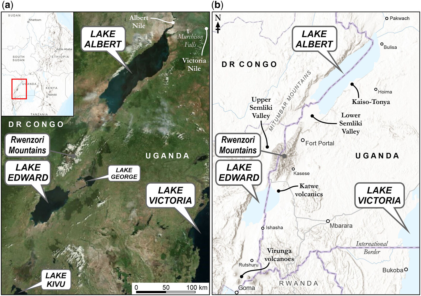
The western branch, the Albertine Rift, is younger, shorter, and, by contrast with the Gregory Rift, relatively poorly known in popular scientific literature despite being, in several dimensions, the more geologically and ecologically significant of the two. The Albertine Rift runs from the northern end of Lake Albert in Uganda southward through Lake Edward, Lake Kivu, Lake Tanganyika, and Lake Malawi, forming the remarkable chain of western rift lakes that are among the deepest freshwater bodies on Earth. It is along the Albertine Rift that the Rwenzori Mountains formed, and the mechanism of their formation is fundamentally different from the volcanic construction of the Gregory Rift’s towering peaks.
Key geological distinction: The Rwenzori Mountains are not volcanic. They are a horst, a block of ancient basement rock uplifted between parallel fault systems as the rift valley floor sank on either side. This makes the Rwenzori the highest nonvolcanic mountain range in Africa and the only major African mountain range whose summit rocks are ancient Precambrian basement, not recent volcanic material.
The Albertine Rift: Africa’s Western Tectonic Trench
Geometry, Depth, and Scale
The Albertine Rift is not a single continuous trench but a series of linked half-graben basins, fault-bounded depressions in which one side has dropped more than the other, creating asymmetric valley profiles separated by accommodation zones where the rift geometry transitions from one fault orientation to another. Each basin contains a lake that reflects its depth and shape: Lake Albert in the north is relatively shallow and wide. Lake Edward is moderate. Lake Kivu is deeper. Lake Tanganyika is extraordinary. At 1,470 metres deep, it is the world’s second-deepest lake and one of the world’s oldest, estimated to be between 9 and 12 million years old. The total depth of the Albertine Rift exceeds 10 kilometers, measured from the summit of the Rwenzori to the bottom of Lake Tanganyika’s sediment-filled basin, a vertical range comparable to the deepest ocean trenches.
The width of the Albertine Rift varies considerably along its length. In the region of the Rwenzori, the rift floor occupied by Lake Edward to the south and the Semliki Valley to the north is approximately 50 to 60 kilometers wide. The rift walls on the Congolese side rise steeply to the Mitumba Mountains, while the Ugandan side is dominated by the extraordinary bulk of the Rwenzori horst, which rises from the rift floor at approximately 700 metres above sea level to the Margherita Peak summit at 5,109 metres a relief of more than 4,400 metres over a horizontal distance of less than 30 kilometers. This rate of relief greater than the western face of the Himalayas in the same horizontal distance makes the Rwenzori’s escarpment one of the most dramatic in Africa.
The Rift Lakes: Biodiversity Consequences of Deep Time
The lakes of the Albertine Rift are not incidental features of the landscape; they are ancient, biologically productive, and ecologically significant in ways that directly relate to the Rwenzori’s own ecological importance. Lake Tanganyika, which formed between 9 and 12 million years ago as the rift deepened, contains approximately 600 species of fish found nowhere else on Earth, a radiation of biodiversity produced by the same long isolation and stable deep-water conditions that produced the Rwenzori’s endemic plant and animal communities. Lake Edward, which forms the southern boundary of the rift depression adjacent to the Rwenzori, is one of the most productive freshwater fisheries in Africa, fed in part by the rivers draining the Rwenzori’s flanks.
The Rwenzori’s rivers, the Mubuku, the Nyamwamba, the Butawu, and others, drain westward and southward into the Albertine Rift lakes system. The Semliki River, which drains northward from Lake Edward into Lake Albert, receives significant input from Rwenzori glacial meltwater. As the Rwenzori glaciers diminish, the hydrological character of these rift-filling rivers changes, a downstream consequence of upstream glaciological change that links the summit zone of the Rwenzori Mountains directly to the ecology and hydrology of the rift valley floor hundreds of metres below.
How the Rwenzori Mountains Were Built: The Horst Mechanism
The formation of the Rwenzori Mountains is a story of what happens when two things occur simultaneously: the rift valley floor sinks, and a block of unusually thick, unusually hard basement crust resists the sinking and instead is forced upward along the bounding fault systems. This process, the formation of a horst, is the structural opposite of the graben formation that creates the rift valley floor, and the two processes are directly linked: the material that drops to form the graben must go somewhere, and in the Rwenzori case, the isostatic and tectonic response to that drop pushed the adjacent block skyward.

The Basement Rocks: Two Billion Years of Foundation
The rocks that form the Rwenzori peaks are among the oldest in East Africa. The basement geology of the Rwenzori consists primarily of Precambrian metamorphic and igneous rocks, gneisses, quartzites, and amphibolites that crystallized deep within the Earth’s crust approximately two billion years ago during the Neoarchean and Paleoproterozoic eras. These rocks were originally sediments and igneous intrusions buried to depths of 20 to 30 kilometers beneath ancient mountain ranges, where the combination of extreme heat and pressure transformed them into the dense, crystalline metamorphic rocks that now form the summit geology of Mount Stanley, Mount Speke, Mount Baker, and the other massifs of the range.
The remarkable age and metamorphic character of these rocks is directly responsible for the Rwenzori’s distinctive grey-black summit geology. The dark, striated rock visible on the upper ridgelines and glacier-stripped faces above Elena Hut contrasts strongly with the light-colored volcanic rock of Kilimanjaro or the pink granites of some Kenyan highland areas. Trekkers with geological curiosity who pick up a rock sample on the upper mountain are holding a fragment of Earth’s Precambrian crust material that was formed when the atmosphere contained almost no oxygen, when the continents were configured in arrangements utterly unlike today’s, and when the most complex life on Earth was single-celled organisms in the shallow seas.
The Uplift Event: Rift Opening and Horst Formation
The Rwenzori’s uplift began approximately three to four million years ago during the Pliocene epoch, when the Albertine Rift branch of the East African Rift System underwent a period of intensified extension. As the rift floor subsided along the bounding fault systems, the western rift margin fault to the east of the Rwenzori and the eastern margin of the Congo Basin to the west, the Rwenzori block, underlain by particularly thick and buoyant basement crust, responded by rising rather than sinking. This phenomenon is a consequence of the isostatic principle: dense lithosphere sinks while buoyant lithosphere rises. The Rwenzori’s basement block is more buoyant than the adjacent rift floor material, and as the fault systems activated to accommodate the regional extension, the buoyant block was squeezed upward between them like a cork pressed between two fingers.
The rate of Rwenzori uplift has been estimated at several hundred metres per million years, modest by the standards of collision-zone mountain building (the Himalayas, for instance, are rising at several millimeters per year due to the ongoing India-Asia collision) but sufficient over three to four million years to produce the current summit altitudes. The uplift is still continuing: geodetic measurements suggest that the Rwenzori is still rising, though the rate of uplift is counteracted by erosion from the extraordinary precipitation the mountain receives, which removes material from the upper slopes at a rate that partially offsets the tectonic rise.
The Fault Systems That Bound the Rwenzori
Two major fault systems bound the Rwenzori block. The Bwamba Fault system defines the western margin of the horst, separating the Rwenzori from the relatively flat rift floor of the Semliki Valley to the west. The eastern fault system, less clearly expressed at the surface, defines the eastern margin of the horst block, separating it from the rift wall terrain that slopes more gradually toward the Ugandan interior. These fault systems are not relict features of a past geological event; they are active faults that continue to accommodate rift extension today, and the Albertine Rift region experiences periodic seismicity as a result.
The seismicity of the Albertine Rift is not trivial. The region has experienced several significant earthquakes in the twentieth and twenty-first centuries, including events of magnitude 6 and above centered in the lake basins and along the rift margins. The Rwenzori itself sits on a seismically active substrate, and while earthquakes during the trekking season are uncommon and the mountaineering risk from seismic activity is low, the fact of ongoing seismicity is a reminder that the forces that built the mountain are still operating; the rift is still opening, the horst is still responding, and the geological story of the Rwenzori Mountains is very much unfinished.
The Rwenzori Through Geological Time: A Timeline
| Time Period | Years Ago | Geological / Ecological Event |
| Archean Eon | ~2 billion years | Formation of basement gneiss and quartzite, the rock that now forms the Rwenzori peaks |
| Miocene | ~25–5 million years | East African Rift System begins opening; proto-rift valleys form across the continent |
| Pliocene | ~5–3 million years | Albertine Rift branch intensifies; Rwenzori horst block begins uplift along major fault systems |
| Pliocene–Pleistocene | ~3–1 million years | Rwenzori uplift accelerates; mountains reach altitude sufficient to support permanent glaciation |
| Pleistocene (glacial max) | ~10,000–20,000 years | Rwenzori glaciers reach maximum extent; ice covers much of the upper mountain range |
| Holocene | ~10,000 yrs–present | Glaciers retreat to current high-altitude remnants, modern vegetation zones are established, and Bakonzo people settle foothills |
| Industrial era | ~1900–present | Anthropogenic climate change accelerates glacier loss; more than 90% of Rwenzori glacial area lost in 120 years |
Glaciation, Climate, and the Ice That Shaped the Summit Zone
The Rwenzori’s current summit topography, including the broad, ice-smoothed ridges, the cirque basins, and the glaciated U-valleys that drain from the upper mountain, is shaped by both glacial erosion and tectonic uplift. The mountain first reached altitudes sufficient to support permanent glaciation approximately one to two million years ago, during the early Pleistocene, as the uplift reached the threshold altitude at which equatorial high-altitude conditions allowed the accumulation of permanent snow and ice.
The Last Glacial Maximum and the Rwenzori’s Ice Extent
At the Last Glacial Maximum (LGM), approximately 20,000 years ago, when global temperatures were approximately 5 to 6°C cooler than today, the Rwenzori’s glaciers were dramatically larger than today. Glaciological reconstructions based on moraines, striations, and erratic boulder deposits suggest that the equilibrium line altitude (ELA), the altitude at which annual accumulation exactly balances annual ablation, was approximately 1,000 metres lower during the LGM than at present. This finding means that permanent ice extended down to approximately 3,500 metres above sea level across the Rwenzori range, covering much of the upper mountain in a continuous ice cap rather than the disconnected remnant glaciers that survive today.

The glacial erosion of the LGM and earlier glacial periods fundamentally shaped the summit landscape that trekkers now cross on the approach to Margherita Peak. The broad, flat-floored valleys that contain the Bujuku and Kitandara Lakes are glacially carved cirques and U-valleys, whose characteristic smooth bowl profiles and steep headwalls are produced by the rotational movement of past ice masses. Glacial plucking and abrasion deepened the depressions in the valley floors that the lakes occupy. The stepped valley profiles visible from the upper mountain, where each altitude band transitions abruptly to the next, reflect the differential erosion rates of successive glacial advances and retreats.
The Role of Glaciation in Shaping Rwenzori Biodiversity
The Rwenzori’s glacial history has been as important to its ecology as to its topography. During glacial maxima, when the ELA dropped and ice expanded over the upper mountain, the vegetation zones were compressed downward. The Afro-alpine plant communities of giant groundsels and lobelias were pushed to lower altitudes, maintaining their ecological continuity while the summit zone above was ice-covered. During interglacial warm periods, when ice retreated upward, the Afro-alpine zone expanded again into the newly exposed terrain.
This repeated contraction and expansion of habitat, what ecologists call “range cycling” had a profound effect on the evolution of the Rwenzori’s endemic plant and animal species. Periods of habitat compression forced populations into refugia, where genetic drift and natural selection could produce rapid evolutionary differentiation. Periods of expansion allowed the newly differentiated populations to spread back across the mountain, sometimes encountering populations that had differentiated in adjacent refugia, producing the complex patterns of endemism and close but distinct species pairs that characterize Rwenzori ecology. The biodiversity of the Rwenzori’s wildlife community is, in a profound sense, a product of the Ice Ages as much as of the present climate.
The Albertine Rift as a Biodiversity Hotspot: Why the Rift Valley Makes Life Extraordinary
The Albertine Rift is recognized as one of the most biodiverse regions on Earth, a global biodiversity hotspot containing a greater density of endemic vertebrate species than any other region in mainland Africa. This extraordinary biological richness is not coincidental; it is a direct product of the rift’s geological history and the physical geography that geology has created.
Isolation, Endemism, and the Biological Island Effect
The Rwenzori’s role as a biological island, a high massif surrounded by the lower rift valley and Congo Basin, has driven an evolutionary process comparable in some respects to the famous adaptive radiations of true island systems. The Rwenzori’s altitude creates an effective barrier to movement for lowland species: most forest birds, mammals, and invertebrates that inhabit the Congo Basin cannot survive at Rwenzori altitudes, and most Rwenzori alpine specialists cannot survive in the lowland forest below. This phenomenon creates a degree of evolutionary isolation for upper-mountain populations that, over the three to four million years of the Rwenzori’s existence as a high-altitude feature, has been sufficient to produce numerous endemic species found nowhere else on Earth.

The Rwenzori turaco (Ruwenzorornis johnstoni), the Rwenzori-endemic heather (Erica johnstonii), the Rwenzori three-horned chameleon (Trioceros johnstoni), and dozens of other species exist in their current forms because the Albertine Rift created a biological island in the 1970s, which has since experienced three to four million years of relative isolation, allowing it to develop its own evolutionary trajectory. The rift that looks, from the summit of Margherita, like a geographical feature is also an evolutionary engine: a machine for producing biological novelty through the mechanisms of isolation, pressure, and time.
Albertine Rift vs. Gregory Rift: Why the Western Branch Is More Biodiverse
A persistent question in African biogeography is why the Albertine Rift appears to generate greater endemism and biodiversity than the older, larger Gregory Rift to the east. The answer is multifactorial, but the most important components are age, stability, and habitat continuity. The Albertine Rift, though geologically younger, has maintained a more stable configuration of lakes and mountain habitats through the Quaternary climatic fluctuations that have repeatedly restructured the Gregory Rift’s vegetation zones. The western rift lakes, particularly Lake Tanganyika, Lake Kivu, and Lake Edward, are ancient enough to have hosted independent speciation processes for millions of years, producing their extraordinary fish faunas. The mountain habitats of the Albertine Rift have similarly maintained greater continuity than the more disrupted and volcanically altered habitats of the Gregory Rift.
| Feature | Albertine Rift | Gregory Rift (Eastern) | Key Distinction |
| Mountain-building mechanism | Horst uplift (non-volcanic) | Volcanic | Rwenzori is unique: Africa’s highest non-volcanic range |
| Highest peak in segment | 5,109 m (Margherita) | 5,895m (Kilimanjaro) | Kilimanjaro higher but is volcanic; Rwenzori is tectonic |
| Biodiversity designation | Global hotspot: highest endemic vertebrate density in Africa | High but less concentrated | Albertine Rift has greater endemism due to long isolation |
| Lake formation | Lakes Albert, Edward, Kivu, Tanganyika | Lakes Turkana, Natron, Nakuru | Albertine lakes older, deeper, more species-rich |
| Rift age (active phase) | ~3–4 million years | ~20–25 million years | Gregory Rift older; Albertine branch younger and still tectonically active |
Walking on the Rift: What Trekkers Experience and What It Means
The geological story of the Albertine Rift is not abstract science when you are physically on the Rwenzori Mountains; it is the material ground beneath your boots, the rock faces above the glacier, and the shape of the valley you are descending. Understanding the rift and the horst transforms the trekking experience from navigating through the landscape into reading it.
The Trail from Nyakalengija to Nyabitaba: Entering the Rift Flank
The trail from Nyakalengija at 1,646 metres to Nyabitaba Hut at 2,651 metres traverses the lower escarpment of the Rwenzori horst, the geological boundary between the rift flank and the mountain’s core. The dense montane forest in this area grows on soils that come from the weathering of the basement metamorphic rocks, creating the rich, red-brown lateritic soils that are typical of the lower mountain. The rivers crossed in this section, including the Mubuku, are rift-drainage rivers flowing perpendicular to the mountain’s strike, cutting through the basement geology toward the rift floor. The sound of these rivers in the lower forest is the sound of geological processes made audible: water moving material from the mountain’s mass toward the rift valley, grain by grain, over millennia.
The Upper Mountain: Reading the Ancient Basement
Above approximately 3,500 metres in the Afro-alpine zone, the thin soils and bog surfaces reveal the basement geology during the 7-day Central Circuit trek and the 8-day three-peaks expedition. Rock outcrops in the upper alpine zone reveal the gneissic banding, the quartzite beds, and the amphibolite intrusions of the Precambrian basement, which is dark grey, densely crystalline, and clearly ancient. The texture of the rock changes character as you ascend: the weathered, soil-covered lower slopes yield way to the bare, glacier-polished surfaces of the upper mountain, where the ice that occupied these faces for thousands of years has stripped away soil and weak rock to expose the basement directly.

The approach to the Scott Elliot Pass (4,372 m) on the Central Circuit, the col between Mount Stanley and the Stanley Plateau, crosses terrain where the mountain’s glacial history is written in the topography. The smooth, rounded profiles of the rock surfaces on the approach to the pass are produced by glacial abrasion: the grinding of rock-laden ice over millions of years has polished the basement outcrops to a characteristic smoothness and rounded any sharp edges that might otherwise protrude. Geologists call these features “roches moutonnées” sheep-shaped rocks, for their distinctive stepped profile: smooth on the up-ice side where abrasion was dominant and rough and plucked on the down-ice side where the ice’s rotational movement pulled blocks from the rock face.
The Rift View from the Summit: A Real-Time Geological Panorama
The summit experience of Margherita Peak , reached on the 7-day Central Circuit summit trek, the 8-day Kilembe Trail expedition, and the faster 5-day Margherita summit option, provides a geological panorama that is available at very few places on Earth. To the west, the Albertine Rift Valley floor is visible in its full width, with the Mitumba Mountains of the DRC forming the western rift wall. To the east, the rift’s eastern shoulder rolls away toward the interior of Uganda. Directly below, the mountain’s flanks drop 4,400 metres to the rift floor, a vertical relief that makes the Rwenzori’s western escarpment one of the most dramatic in Africa.
On the clearest days, most likely in January or February or the dry-season months of July and August, the distant sheen of Lake Albert is visible to the north and the expanse of Lake Edward to the south. Both lakes occupy the rift floor, separated from each other by the topographic high of the Rwenzori’s southern foot. From the summit, one can see both the lakes that express the rift in water and the mountain that expresses it in uplifted rock, allowing for a single glance at the Albertine Rift’s tectonic duality. The scene is a view that no photograph can fully translate.
The Rift Today: Ongoing Tectonics and the Future of the Rwenzori
The Albertine Rift Is Still Active
The Albertine Rift is not a fossil feature of past tectonics. It is an actively extending rift system whose seismicity, volcanism (in the Virunga section to the south), and crustal motion continue to the present day. GPS measurements across the Albertine Rift show ongoing extension at rates of several millimeters per year, slow by human standards but geologically significant and cumulatively transformative over the millions of years of rift evolution ahead. The Rwenzori’s bounding fault systems, the Bwamba Fault on the west and the eastern margin faults, accommodate a portion of this ongoing extension through periodic earthquakes, and the horst block continues its isostatic response to the progressive loading and unloading of its surface by glaciation, erosion, and precipitation.

The Virunga volcanic field, which includes Nyiragongo, one of the world’s most active volcanoes with its permanently fluid lava lake, represents the most actively volcanic section of the Albertine Rift and is located approximately 250 kilometers south of the Rwenzori. The contrast between the Rwenzori’s non-volcanic, Precambrian horst character and the young, active volcanism of the Virunga section to the south reflects the along-strike variation in rift character. The northern Albertine Rift around the Rwenzori is dominated by tectonic uplift and faulting, while the southern section is where significant magmatic activity is associated with the rift extension.
What the Rift Means for the Future of the Rwenzori
Over geological timescales of tens of millions of years, the continued extension of the Albertine Rift will ultimately produce a new ocean basin separating East Africa from the main continental mass. This is the fate of all successful continental rifts: the East African Rift will, like the Red Sea before it, eventually transition from a continental rift to a narrow ocean basin, then gradually widen into a full ocean. The Rwenzori, as a horst block on the rift margin, will continue to be modified by this process, uplifted or downfaulted depending on the local structural response to the ongoing extension, and continuously eroded by the extraordinary precipitation that the mountain generates from its unique position in the atmospheric moisture field between the Congo Basin and Lake Victoria.
On the timescale relevant to trekkers, which spans decades and centuries, the loss of glaciers is the most significant geological and geomorphological change affecting the Rwenzori. As we have seen, the glaciers are a result of Pleistocene glaciation responding to present-day warming, and their loss will change the hydrology of the rift drainage system, the plant life on the upper mountain, and the summit experience that attracts thousands of trekkers each year. Seeing the Rwenzori in its current glaciated form is not just an aesthetic argument but also a geological one: you are seeing the mountain at a specific point in its long geological story, a point at which equatorial glaciers are still present but only just, and that particular chapter is closing.
A window that is closing: The Rwenzori’s equatorial glaciers are a geological anomaly in the current climate, remnants of the Pleistocene ice ages that are not being replaced under current warming conditions. Visiting the mountain now is an opportunity to observe a geological and climatological transition in real time at the place where it is most dramatically visible anywhere in Africa.
The Semliki Valley: The Rift Floor at the Rwenzori’s Foot
The Semliki Valley, the section of the Albertine Rift floor immediately to the west of the Rwenzori, connecting Lake Albert in the north to Lake Edward in the south, is one of the most biologically important landscapes in the Albertine Rift system. Its lowland tropical forest, the Semliki Forest, is the only Ugandan lowland forest with a true Congolian character, sharing more species with the Congo Basin forests to the west than with the other Ugandan forests to the east. This biogeographical anomaly is a direct result of the Albertine Rift’s geological history: the Semliki is a lowland corridor that has periodically connected the Congo Basin to the East African highlands as climate and vegetation belts shifted, allowing species exchanges that have left a complex imprint on the region’s biodiversity.
For trekkers combining the Rwenzori Mountains with a broader Uganda expedition, such as the 16-day Rwenzori and gorilla trekking combination or the 19-day ultimate Uganda adventure, the drive from Kasese to the Rwenzori trailhead goes along the eastern edge of the rift, showing views of the rift wall topography and the striking difference in landscape between the flat-floored Semliki and the steep-rising Rwenzori escarpment. This topographic contrast, the rift floor and the mountain wall in a single view, is the most immediate and visually accessible expression of the Albertine Rift’s geological architecture available to any visitor.
Frequently Asked Questions: The Albertine Rift and Rwenzori Mountains Geology
What is the Albertine Rift, and how is it connected to the Rwenzori Mountains?
The Albertine Rift is the western branch of the East African Rift System, a zone of crustal extension running from Uganda’s Lake Albert in the north through Lake Edward, Lake Kivu, Lake Tanganyika, and Lake Malawi in the south. It is a geologically active rift created by the tensional forces that are gradually pulling the East African portion of the African continent apart from the main mass. The Rwenzori Mountains are a direct product of this rifting: as the rift valley floor subsided along bounding fault systems, the adjacent Rwenzori block of ancient basement rock, being particularly thick and buoyant, was forced upward rather than downward. This formed a horst (an uplifted crustal block), and over approximately three to four million years, the ongoing uplift has built the Rwenzori’s summits to their current altitudes, with Margherita Peak reaching 5,109 metres.
Are the Rwenzori Mountains volcanic?
No. The Rwenzori Mountains are not volcanic, a fact that makes them fundamentally different from most of Africa’s other major mountain ranges. Kilimanjaro, Mount Kenya, Mount Meru, and the Virunga volcanoes are all products of volcanic activity associated with the East African Rift System. The Rwenzori, by contrast, are a horst, a block of ancient Precambrian basement rock (primarily gneisses and quartzites approximately two billion years old) that was uplifted between parallel fault systems as the Albertine Rift opened. There is no volcanic edifice beneath the Rwenzori, no magmatic plumbing system, and no history of eruption. The rocks of the Rwenzori’s summit zone are among the oldest exposed at the surface in East Africa.
How old are the Rwenzori Mountains?
The rocks that form the Rwenzori Mountains are approximately two billion years old and consist of Precambrian metamorphic basement materials, including gneisses, quartzites, and amphibolites, that formed deep within the ancient crust. However, the mountains themselves, meaning the topographic feature of an elevated mountain range, are much younger. The Rwenzori’s uplift began approximately three to four million years ago during the Pliocene epoch, when the Albertine Rift branch of the East African Rift System underwent intensified extension and the Rwenzori horst block began rising along bounding fault systems. The current summit altitudes were reached more recently than the mountains; the Rwenzori was probably at or near its current height within the last one to two million years.
What is a horst, and why does that make the Rwenzori unique?
A horst is an uplifted block of crustal rock bounded on at least two sides by downfaulted zones (grabens). In the context of the Albertine Rift, as the rift valley floor subsided between bounding fault systems, the Rwenzori block, underlain by particularly thick and buoyant basement crust, was pushed upward by the isostatic response to surrounding subsidence rather than sinking with the rift floor. This makes the Rwenzori the only major mountain range in Africa built by tectonic uplift rather than volcanic construction, and Africa’s highest non-volcanic mountain range. The geological distinction is significant: the Rwenzori’s summit rocks are ancient Precambrian basement, not young volcanic material, and the mountain’s topography reflects structural geology and glacial erosion rather than volcanic landforms.
Why is the Albertine Rift the world’s most biodiverse rift valley?
The Albertine Rift is recognized as a global biodiversity hotspot containing a greater density of endemic vertebrate species than any other region in mainland Africa. Several geological and ecological factors contribute to this extraordinary richness. The rift’s relative stability during the Quaternary climatic fluctuations has maintained longer habitat continuity for species evolution compared to the more disrupted Gregory Rift to the east. The great age of the rift lakes, Lake Tanganyika, which is 9 to 12 million years old and contains approximately 600 endemic fish species, has provided time for extensive species radiation in both aquatic and terrestrial environments. The physical geography of the rift, with its high mountain walls (including the Rwenzori horst at 5,109 metres) creating effective barriers to gene flow, has allowed populations on adjacent mountain ranges to evolve independently, producing the high endemism characteristic of the Albertine Rift’s mountain communities.
What was the Rwenzori like during the Ice Ages?
During the Last Glacial Maximum approximately 20,000 years ago, global temperatures were about 5 to 6°C cooler than today, resulting in the Rwenzori’s glaciers being dramatically larger than their present-day remnants. Glaciological reconstructions based on moraine deposits, glacial striations, and erratic boulders suggest that the equilibrium line altitude (ELA), the altitude at which annual ice accumulation balances annual melt, was approximately 1,000 metres lower than at present. This means that permanent ice extended down to approximately 3,500 metres across the range, covering much of the upper mountain with a continuous ice cap. The present-day U-shaped valleys, cirque basins, and glacially polished rock surfaces of the upper mountain are all products of this more extensive Pleistocene glaciation. The lakes at Bujuku and Kitandara occupy glacially carved depressions from this period.
Is the East African Rift going to create a new ocean?
Yes, over geological timescales of tens of millions of years, the continued extension of the East African Rift System will eventually produce a new ocean basin separating East Africa from the main African continent. This is the standard trajectory of successful continental rifts: the East African Rift will, like the Red Sea before it, transition from a continental rift to a narrow seaway and eventually to a full ocean basin as extension continues and sea floor spreading begins. The Red Sea represents an earlier stage of this same process, a former continental rift that has now begun generating oceanic crust. The East African Rift is perhaps 20 to 30 million years behind the Red Sea in this process. On human timescales, this geological future has no practical consequence, but it contextualizes the Rwenzori’s origin: the mountain was created by the same planetary process that will eventually isolate East Africa as a separate micro-continent.
Can you see the Albertine Rift from the Rwenzori Mountains?
Yes, on clear days, particularly during the drier months of January, February, July, and August, the view from the upper mountain and from Margherita Peak provides a dramatic panorama of the Albertine Rift Valley. To the west, the flat-floored Semliki Valley and the rift’s Congolese wall are visible, with the Mitumba Mountains of the DRC forming the western rift margin. Lake Albert may be visible to the north and Lake Edward to the south on the clearest days. The vertical relief from the Margherita summit to the rift valley floor is more than 4,400 metres over a horizontal distance of less than 30 kilometers, making the Rwenzori’s western escarpment one of the most dramatic relief transitions in Africa. The view from the summit makes the tectonic relationship between the rift and the mountain viscerally clear.
Come and Stand Where Continents Pull Apart
There are very few places on Earth where you can stand on two billion years of continental crust, look down 4,400 metres into an actively extending rift valley, observe equatorial glaciers whose days are numbered, and be surrounded by a biological community that evolution constructed under the specific conditions created by the tectonic and glacial history beneath your boots. The Rwenzori Mountains are one of those places. Perhaps the Rwenzori is the most extraordinary of all.

The geological story we have traced in this article from the Precambrian basement formation through the Albertine Rift’s opening, the Rwenzori’s horst uplift, the Ice Age glaciations, and the accelerating present-day glacier retreat is not background information for a visit to the mountain. It is the mountain, understood completely. Every step of the Central Circuit Trail traverses a different chapter of this story. Every camp from Nyabitaba to Elena Hut sits at a different geological altitude. The Coronation Glacier that you cross on the way to Margherita Peak is the last surviving remnant of an ice cap that covered this mountain for tens of thousands of years. Walk on it with that knowledge, and the summit experience carries a weight and a meaning that no altitude measurement can express.
Whether your Rwenzori expedition begins with a 7-day summit trek, the comprehensive 13-day six-peaks grand expedition, or a first encounter through the 3-day Mahoma Loop forest walk, the geological story of the Albertine Rift is present in everything you will experience on the mountain. Our guides are trained to interpret this story alongside the ecology, the culture, and the human history of the range because the Rwenzori only makes complete sense when all its layers are read together.
Explore our full range of Rwenzori trekking itineraries, plan your visit using our month-by-month seasonal guide, read the 30 incredible facts about the Rwenzori that contextualize everything this article has explored, and when you are ready to stand on a mountain that the earth is still building, contact our expedition team directly. We will help you design the perfect journey into one of Earth’s most extraordinary geological landscapes.


