Rwenzori Mountain Peaks: The Complete Guide to Africa’s Mountains of the Moon.
Discover everything about the Rwenzori Mountain Peaks, from Margherita Peak (5,109 m) to Mount Gessi. Expert guide covering all 6 massifs, routes, costs, packing & best seasons. Plan your bespoke Uganda mountain trek with Rwenzori Trekking Safaris.
You’ve done Kilimanjaro. You’ve read about the Himalayas. And yet something keeps drawing you back to the map of Central Africa to that strange, mist-wrapped cluster of peaks straddling the border of Uganda and the Democratic Republic of the Congo. There’s a reason the ancient Greek geographer Ptolemy called them the Mountains of the Moon. Standing on one of the Rwenzori mountain peaks doesn’t feel like anything else in African mountaineering. It feels like stepping into another world entirely.
This is not a checklist mountain. The Rwenzori range rewards trekkers who come prepared, who want a guide who knows which moss-covered boulder is a foothold and which is a trap, and who understand that the real value of this journey isn’t just standing on a summit; it’s every single hour of immersion in one of the most biologically complex and geologically ancient landscapes on the planet.
This guide covers everything: the six major Rwenzori mountain peaks in full detail, the routes that reach them, the experience of trekking through five distinct vegetation zones, timing, costs, packing, and every practical question you need answered before you book. If you want a personalized trek, not a cookie-cutter itinerary handed to a hundred people a year, read this guide carefully and then get in touch with our team. We’ve spent over a decade building itineraries specifically around what individual trekkers want from this mountain.
What Makes the Rwenzori Mountain Peaks Unlike Anything Else in Africa
Most of Africa’s highest mountains are dramatically volcanic, solitary, and geologically young. Kilimanjaro and Mount Kenya rose from lava. The Rwenzoris are fundamentally different. These mountains are among the oldest on the continent, formed from ancient crystalline basement rocks through a process of tectonic uplift along the Albertine Rift Valley. They were pushed skyward not through eruption but through faulting and folding over millions of years, and that origin imparts them a character that no volcano can replicate.
The result is a complex, multi-summited range where six major massifs rise above 4,600 meters, each with multiple named peaks, glaciers, alpine lakes, and entirely distinct personalities. You don’t just climb a mountain here; you move through an interconnected world of summits, saddles, and corridors that requires genuine navigation, physical endurance, and a deep respect for the mountain’s rapidly changing weather.
The range lies just 33 kilometers north of the equator, and that equatorial position combined with the extreme altitude creates a phenomenon that confounds first-time visitors: equatorial glaciers. The Rwenzori Mountains are one of only three places in Africa where permanent glaciers exist, and unlike Kilimanjaro‘s receding ice cap, the Rwenzori glaciers are genuine mountain glaciers, born of snow compression and shaped by gravity. They are, however, retreating at an alarming rate due to climate change, which makes trekking here now while the glaciers still exist an urgent priority for anyone who wants the complete experience.
The range sits within Rwenzori Mountains National Park, a UNESCO World Heritage Site covering approximately 1,000 square kilometers. Managed by the Uganda Wildlife Authority, the park not only protects the mountains but also a unique variety of plants and animals, including the Rwenzori turaco, three-horned chameleon, giant lobelias, tree heathers covered in old-man’s-beard lichen, and tall groundsels. Nowhere else on earth does the transition from equatorial rainforest to glaciated summit happen in such a concentrated, dramatic fashion.
The Six Major Rwenzori Mountain Peaks: A Complete Guide
The Rwenzori range has six major massifs, each named after a historical figure, explorer, patron, or expedition member. Every massif in the Rwenzoris carries multiple summits, offering a staggeringly varied range of trekking options. Below is a detailed breakdown of every major peak, its elevation, character, and what the experience of climbing it actually involves.
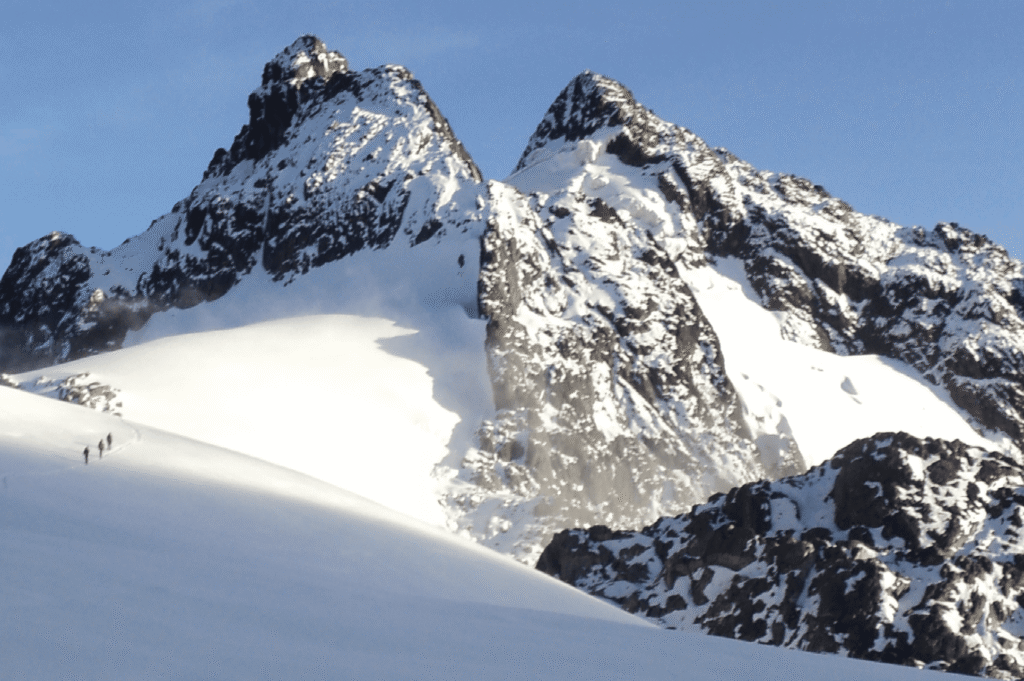
Mount Stanley: The Crown of the Rwenzoris (5,109 m)
Every conversation about the Rwenzori mountain peaks begins here. Mount Stanley is the highest massif in the range and the third-highest mountain in all of Africa, surpassed only by Kilimanjaro and Mount Kenya. The massif, named after the explorer Sir Henry Morton Stanley, spans a vast, glacier-draped plateau and boasts multiple peaks.
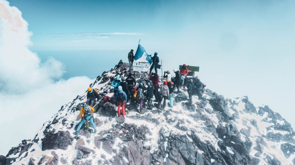
The highest point is Margherita Peak, which stands at 5,109 meters (16,762 feet) above sea level. Named after Queen Margherita of Italy, it was first summited in 1906 by the Duke of Abruzzi’s expedition, the same expedition that systematically mapped and named much of the range. From Margherita, on a rare clear morning, you can look across a sea of clouds to Alexandra Peak to the north and watch light creep up the Stanley Plateau with a softness that makes the entire journey feel worthwhile.
Alexandra Peak, the second summit on Mount Stanley at 5,091 meters, is often climbed on the same summit push as Margherita, and the approach across the Stanley Plateau, a glaciated high-altitude crossing at over 5,000 meters, is one of the most extraordinary walking experiences in all of African mountaineering. Albert Peak, the third summit, sits slightly lower and requires more technical terrain to reach.
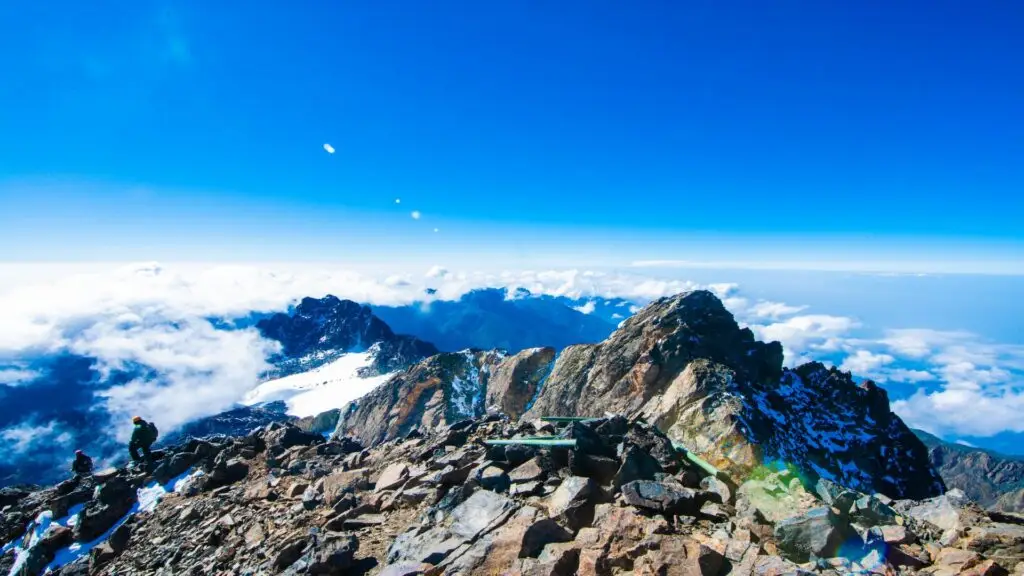
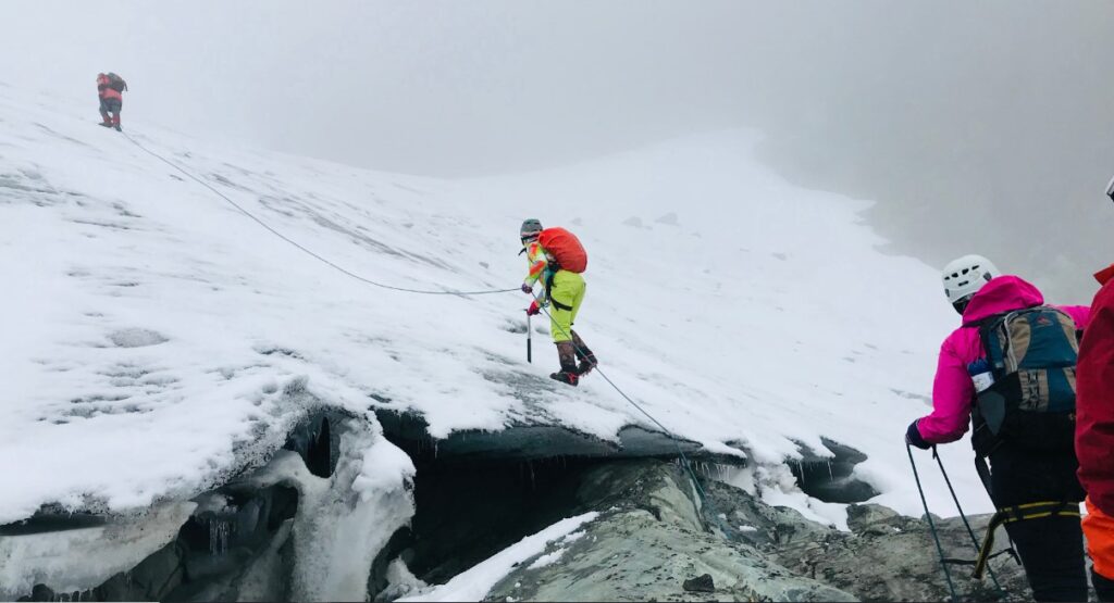
The technical challenge of reaching Margherita should not be underestimated. The upper section involves glacier travel with crampons and ice axes, roped movement, and exposure to severe weather that can roll in with almost no warning. A guide who has made the glacier crossing dozens of times isn’t a luxury here; it is a non-negotiable requirement. Every trekker we take to Margherita is fully equipped, properly acclimatized, and moves with a guide who knows every step of the glaciated section intimately.
Most itineraries that include Margherita Peak require a minimum of seven to eight days on the mountain. Our 7-day Central Circuit trek is one of the most popular ways to reach the summit, while the 8-day Kilembe Trail expedition offers a different angle on the approach with its own distinct character.
Mount Speke: The Quiet Giant (4,890m)
Named after the great Nile explorer John Hanning Speke, Mount Speke is the second-highest mountain in the Rwenzori range and arguably the most underrated. While most trekkers focus their ambitions on Margherita, those who take the time to summit Speke are rewarded with something perhaps more intimate: a peak that feels earned in a different way, with approaches that cut through some of the most beautiful alpine terrain in the range.
The highest point on Mount Speke is Vittorio Emanuele Peak at 4,890 meters, named after the Italian king who was the reigning monarch during the Duke of Abruzzi’s 1906 expedition. The summit sits above the Bujuku Valley, a glacial trough that is one of the most dramatic natural features in the entire park, with its lake reflecting the surrounding peaks on calm mornings in a way that stops even experienced mountaineers in their tracks.
For trekkers wanting to experience multiple peaks, our 9-day Rwenzori trek covering three peaks Mount Stanley, Speke, and Baker is the most complete way to experience the upper range of the Rwenzoris. Those who want to focus specifically on Speke can explore ourdedicated 5-day Mount Speke hike.
Mount Baker: Edward Peak and the Freshfield Pass (4,843m)
To the south of the Bujuku Valley lies Mount Baker, the third-highest massif in the range. Its highest point, Edward Peak at 4,843 meters, is accessed via the Scott Elliot Pass and the Freshfield Pass, two of the most dramatic saddles in the Rwenzoris, where the path narrows between sheer rock walls and the views drop away on both sides into distant valleys.
Mount Baker has a severe, sculptured quality that many trekkers find the most visually striking of all the Rwenzori massifs. The rock formations on its upper ridge are ancient and complex, the result of millions of years of glacial carving, and the final push to Edward Peak requires scrambling over bare rock at high altitude not technical climbing in the roped sense, but demanding enough to remind you that you are very much on a mountain.
The5-day Edward Peak trek via Freshfield Pass is designed for trekkers who want to focus on Baker specifically. The route crosses some of the most scenic high-altitude terrain in the range and is an ideal introduction to the upper peaks for those who are not ready for the glacier travel required on Margherita.
Mount Emin: Legacy of the Naturalist Explorer (4,798m)
Of the six major Rwenzori massifs, Mount Emin is perhaps the most remote. Named after Emin Pasha, the German physician and naturalist whose real name was Eduard Schnitzer and who spent years in Central Africa as a colonial administrator and explorer, Mount Emin sits in the northern sector of the range and demands a longer approach than most of the other major peaks.
Its highest point stands at 4,798 meters. The massif carries two main summits, and its northern position means that many trekkers who explore the central massifs never reach it. This remoteness is, for those who seek it, a powerful draw. The approaches to Emin pass through vegetation zones that see far fewer boots than the central corridors, and the sense of genuine wilderness here is profound.
Trekkers with serious endurance and a desire for a more isolated, self-sufficient experience on the mountain are the target audience for our 7-day Mount Emin hiking itinerary. It pairs beautifully with the 13-day, 6-peak expedition for those who want the full crown of the Rwenzoris.
Mount Gessi: Africa’s Hidden High-Altitude Gem (4,715m)
Named after Romolo Gessi, the Italian explorer and soldier whose cartographic work in Central Africa opened the door for subsequent expeditions, Mount Gessi stands at 4,715 meters and occupies the far northeastern corner of the Rwenzori range. Like Emin, it sees far fewer trekkers than the central massifs, which is precisely what makes it extraordinary.
Gessi has two main summits, Iolanda and Bottego, and the approaches pass through some of the most botanically rich terrain in the park. This is where the giant groundsels reach their most surreal dimensions, growing in dense clusters beside alpine lakes, and where the silence is so complete that you become acutely aware of every footfall and every shift in wind direction.
The 7-day Mount Gessi trek is an expedition for trekkers who measure success not by summit elevation but by depth of experience. Combining Gessi with Emin as we do in our comprehensive 13-day 6-peaks expedition creates one of the most complete mountain journeys available anywhere in East Africa.
Mount Luigi di Savoia: Sella and Weismann Peaks (4,627m)
The most accessible of the six major Rwenzori massifs, Mount Luigi di Savoia is named after the Duke of Abruzzi himself, Luigi Amedeo di Savoia, who led the 1906 expedition that first mapped and climbed so much of the range. The massif carries two main summits: Sella, the higher at 4,627 meters, and Weismann Peak, which sits slightly lower but is considerably more accessible and is a popular target for trekkers on shorter itineraries.
Weismann Peak is a summit that rewards you with a genuine high-altitude experience without demanding the full technical preparation that Margherita requires. The way to get to the summit using either the Kilembe Trail or the Central Circuit goes through typical Rwenzori scenery, including huge heather plants, forests of lobelia, and wet moorland with glacial lakes, and from the top, you can see an amazing view of the southern part of the mountain range that you won’t
The 6-day Weismann Peak hike is one of our most popular itineraries for trekkers visiting the Rwenzoris for the first time, offering a genuine summit experience on a major Rwenzori peak without requiring glacier travel.
The Five Vegetation Zones: What You’ll Walk Through on the Way to the Peaks
One of the most remarkable aspects of trekking the Rwenzori mountain peaks is the sheer variety of landscapes you pass through on a single expedition. Because the range rises from approximately 1,600 meters at its base to over 5,000 meters at its summits, it compresses multiple entire ecosystems into a vertical journey that takes days to traverse. No two days feel the same, and the landscape transformations are among the most dramatic in mountain trekking anywhere in the world.
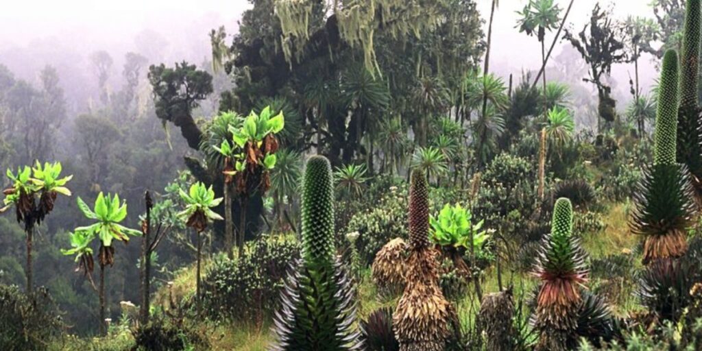
The montane rainforest at the base of the range is dense, dark, and alive with sound. Colobus monkeys crash through the canopy above you, L’Hoest’s monkeys peer from the undergrowth, and the calls of the Rwenzori turaco, a bird found nowhere else on earth, echo through the trees. The forest floor is thick with roots and mud, and the paths require careful footwork from the first hour. This area is not the clean gravel of a well-groomed trail; it is a living ecosystem through which you are a temporary guest.
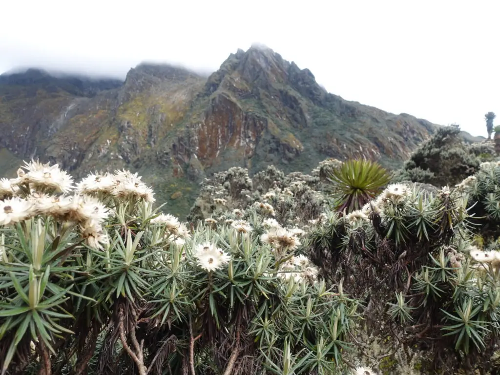
As you gain altitude, the bamboo zone takes over a transitional forest that muffles sound and filters light differently, creating an almost underwater quality. Then comes the heath zone, where the world opens up and giant heathers grow to six or eight meters in height, draped in old-man’s-beard lichen that catches the morning mist and glows silver in the late afternoon sun. This section is the zone that defines the Rwenzori aesthetic more than any other: strange, ancient, and profoundly beautiful.
Higher still, the Afro-alpine moorland spreads across the upper valleys. Giant lobelias rise from boggy ground like green obelisks, their rosettes catching rainwater in pools that reflect the sky. Giant groundsels, Dendrosenecio, stand like prehistoric trees, their thick trunks and crowns of leaves creating a landscape that feels genuinely alien. The wetness of this zone is extraordinary; the Rwenzoris receive some of the highest annual rainfall of any mountain range in Africa, and the bog crossings require adequate waterproof boots and a philosophical acceptance of wet feet.
Finally, above the moorland, the nival zone, the world of rock, ice, and glacier, announces itself. The air is thin, the temperature drops sharply, and the vegetation falls away to bare stone and ice. This section is the zone from which the Rwenzori peaks emerge, and the contrast between the lush world below and this stark, glaciated upper landscape is one of the most powerful sensory experiences on the mountain.
How to Choose the Right Route to the Rwenzori Mountain Peaks
There are three main trails that provide access to the Rwenzori mountain peaks, each with its character, difficulty profile, and set of experiences. Choosing the right one depends on your summit goals, the amount of time you have, and the kind of trekking experience you want. Here is an honest assessment of each.
The Central Circuit Trail
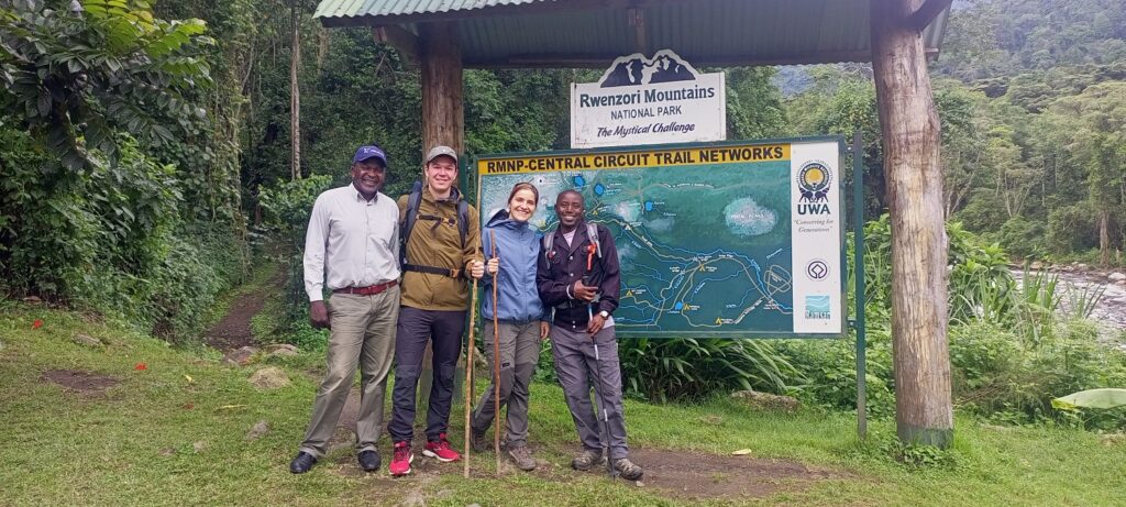
The Central Circuit Trail is the original Rwenzori route, and it remains the most complete way to experience the full range of the mountains. Starting from the Nyakalengija trailhead near the village of Ibanda in Kasese District, it loops through the heart of the range, passing through five distinct vegetation zones and connecting the major huts at Nyabitaba, John Matte, Bujuku, Elena, Kitandara, and Guy Yeoman.
This route passes beneath the three highest massifs, Stanley, Speke, and Baker, which means that summit bids on all three can be incorporated into a single extended itinerary. The terrain on the Central Circuit is challenging but not technically extreme at its lower elevations, making it accessible to trekkers with good fitness and a determination to push through the unavoidable mud and bog. The hut system is well-maintained, and the route has enough established infrastructure to make logistics straightforward when planned properly.
For the standard Central Circuit experience, our 7-day Central Circuit trek is the benchmark itinerary, while trekkers wanting to stand on multiple summits should consider the 9-day three-peaks expedition that covers Stanley, Speke, and Baker.
The Kilembe Trail
The Kilembe Trail begins from the old copper mining town of Kilembe and enters the range from the south, ascending via the Nyamwamba Valley to a series of high camps, including Sine, Mutinda, and Margherita Camp, before reaching the upper peaks. It is managed by Rwenzori Trekking Services in partnership with the Uganda Wildlife Authority, and the camps along this route are among the best-maintained in the range, with several featuring solar charging panels.
The Kilembe Trail is longer and in some respects more demanding than the Central Circuit; it involves more sustained elevation gain, and the camps are more exposed to the elements at higher elevations. But the rewards are proportionate. The scenery along the Kilembe route, particularly in the upper sections around Mutinda Lookout, is spectacular in a way that even seasoned Rwenzori trekkers find humbling. The trail’s less frequent use compared to the Central Circuit intensifies the sense of solitude and wild remoteness.
Our 8-day Kilembe Trail expedition to Margherita Peak is our recommended itinerary for trekkers who want to reach the summit with sufficient acclimatization time built in. For those who want a shorter introduction to this route, the 4-day Mutinda Loop via Kilembe offers spectacular high-altitude views without committing to a full summit bid, and the 8-day Cheptegei Peak trek is ideal for trekkers targeting this secondary summit at 4,907 meters.
The Bukulungu Wilderness Trail
The newest of the three main routes, the Bukulungu Wilderness Trail was established through a partnership between the Uganda Wildlife Authority and the World Wildlife Fund in 2018. This trail is for trekkers who want the most untouched, raw wilderness experience the Rwenzoris can offer, and it delivers that in full.
The Bukulungu route passes through terrain that sees very few visitors, and the four alpine lakes it passes Irene, Mughuli, Bukurungu, and Bujuku are among the most pristine high-altitude waterbodies in all of East Africa. There are no established huts on this trail; trekkers camp in tents, sleeping under extraordinary skies and waking to views that no photograph quite captures. For those who want a genuinely wild experience on the Rwenzori mountain peaks, this trail stands apart.
How Long Does It Take to Climb the Rwenzori Mountain Peaks?
The duration of your trek depends entirely on which peaks you’re targeting, which route you’re taking, and, critically, how seriously you take acclimatization. The Rwenzori Mountains rise to over 5,100 meters above sea level, and altitude sickness is a real risk for anyone who ascends too quickly. It is always better to spend an extra day on the mountain than to push the schedule and end up turning around short of your summit because your body hasn’t had time to adjust.
For trekkers targeting Margherita Peak, the summit of Mount Stanley, the realistic minimum is seven days, and eight to ten days is far preferable for most trekkers, allowing for proper acclimatization nights and a weather buffer around the summit push. On the Kilembe Trail, eight to twelve days is the standard range. Short treks of three to five days are available for lower elevations and secondary objectives, and these can be enormously satisfying in their own right; the landscape transforms dramatically even without reaching the glaciated peaks.
At the other end of the spectrum, our 13-day expedition covering all six Rwenzori peaks Stanley, Speke, Baker, Emin, Gessi, and Luigi di Savoia is the most comprehensive mountain journey available in the range, and our 18-day expedition covering all eight peaks is genuinely one of the most ambitious mountain itineraries in all of Africa. These treks are not for the faint of heart, but those who finish carry the experience for life.
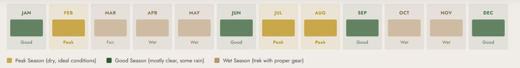
The Best Time to Climb the Rwenzori Mountain Peaks.
The best time to visit the Rwenzori Mountainsis during the two main dry seasons: December to February and June to September. These months offer the most stable weather, the driest trail conditions, and the best visibility on the upper peaks. The park experiences its peak visitor numbers during the dry season months, so we strongly recommend booking well in advance for these windows.
That said, calling these months “dry” requires a caveat. The Rwenzori range receives some of the highest annual rainfall in East Africa over three meters in places and the mountains generate their own weather systems regardless of the calendar. Even in the driest months, you should expect mist, occasional rain, and the persistent dampness that gives the range its lush, otherworldly character. Waterproof gear is never optional here; it is the foundation of your clothing system at every elevation.
The wet seasons, March to May and October to November, are genuinely challenging on the Rwenzori mountain peaks. The trail conditions deteriorate significantly, the bog crossings become extreme, and visibility on the upper peaks can be nil for days at a stretch. But the wet season has its fans: the mountain is quieter, the vegetation is more vivid, and the waterfalls in the lower forest zones are more spectacular. Trekkers who have experienced the Rwenzoris in both seasons often describe the wet season as the more raw and honest version of the mountain: harder and wetter, but more profoundly wild.
Whatever the season, one thing never changes: the need for a guide who knows this mountain. The Rwenzori trails are not waymarked with the regularity of more heavily touristed mountains. Route-finding in poor visibility on the upper sections requires experience that cannot be improvised.
Getting to the Rwenzori Mountains
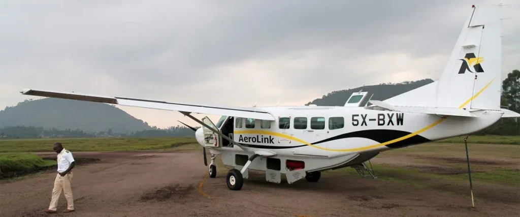
The gateway to the Rwenzori Mountains is Kasese, a town in western Uganda approximately 400 kilometers from the capital, Kampala. From Entebbe International Airport, Uganda’s main international hub, well connected to Nairobi, Addis Ababa, Doha, Dubai, and Amsterdam, there are several options for reaching the mountains.
The fastest option is a domestic flight from Entebbe to Kasese on AeroLink or a similar carrier. The flight takes approximately one hour and delivers you to the foot of the range on the same day you arrive internationally, which is a significant advantage for trekkers on tight schedules. Flights operate once daily, so scheduling requires care.
The overland drive from Kampala to Kasese takes approximately five to six hours and offers a spectacular journey through Uganda’s fertile western highlands, with the option to stop at the Toro Kingdom’s royal palace in Fort Portal, a worthwhile cultural detour that contextualizes the history and culture of the Bakonzo people, who consider the Rwenzori Mountains their ancestral home and refer to them as rainmakers. For trekkers connecting from Kigali, Uganda’s mountainous southwest border is just a few hours’ drive, making the Rwenzoris highly accessible for those also undertaking gorilla trekking in Rwanda or Uganda.
Combining the Rwenzori Mountain Peaks with a Uganda Safari
One of the most wildlife-rich corners of Africa is home to the Rwenzori Mountains. Within a few hours’ drive of the Kasese trailhead, you have Queen Elizabeth National Park, home to tree-climbing lions, massive herds of buffalo, hippo-filled channels, and over 600 bird species. Bwindi Impenetrable Forest, the globally celebrated home of mountain gorillas, is within comfortable striking distance to the south. And Murchison Falls National Park, with its thundering Nile and enormous crocodile population, lies to the north.
The Rwenzori Mountains also pair exceptionally well with trekking elsewhere in the region. For those who want to experience multiple outstanding mountain ranges in one trip, we offer a combined Rwenzori and Mount Karisimbi package that takes in both the Rwenzoris and Rwanda’s Virunga volcano massif in a single extended itinerary.
How Much Does It Cost to Climb the Rwenzori Mountain Peaks?
The cost of climbing the Rwenzori Mountains depends on several factors: the route you take, the number of days on the mountain, the number of peaks targeted, and any additional services such as equipment rental or pre-trek accommodation. As a baseline, trekkers targeting Margherita Peak should budget from approximately $1,300 upwards for the mountain component of their trip, with the total rising based on the factors above.
Expedition packages typically include guiding fees, all porters, hut accommodation or camping on the mountain, all meals during the trek, park fees, and essential equipment support. What is not usually included in a standard package price are international flights, pre-trek accommodation in Kasese or Kampala, travel insurance, visa fees, and gratuities for the guide and porter team, all of which should be budgeted for separately. Trekkers targeting all six peaks on the 13-day expedition should expect to budget $3,500 or above for the full experience, including all the above components.
Tipping is a meaningful part of the Rwenzori trekking economy, and the guide and porter team work extraordinarily hard in difficult conditions to make every summit bid possible. A commonly followed guideline is to budget roughly 8-12% of the total trek cost for gratuities, distributed across the entire support team with care and genuine gratitude. The porters and guides on these mountains are among the most skilled, knowledgeable, and physically formidable mountain professionals in East Africa; treating them accordingly is both ethically right and practically essential for a successful expedition.
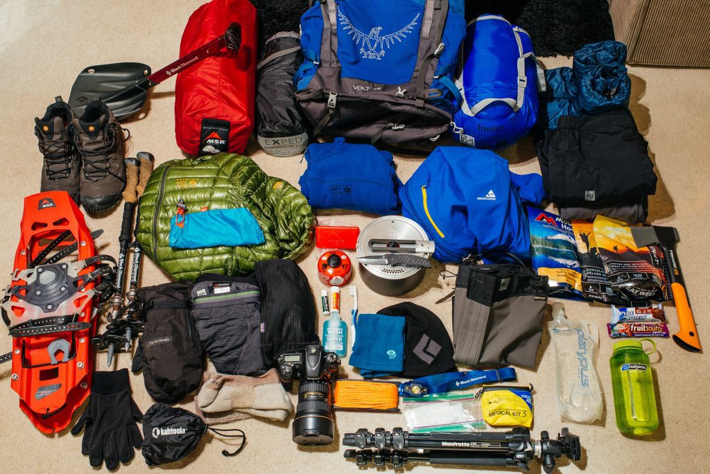
What to Pack for the Rwenzori Mountain Peaks
Packing for the Rwenzori mountain peaks requires a layering system that covers everything from humid tropical rainforest at 1,600 meters to glaciated terrain at 5,100 meters, sometimes within the same week. The Rwenzori is wet year-round, so all layers must work. Cotton has no place in your bag; every item should be synthetic or wool.
Waterproof hiking boots are non-negotiable, and they should be well broken-in before you arrive. The bog crossings and root-covered forest trails in the lower zones will immediately expose any weakness in footwear. Waterproof over-trousers and a fully waterproof jacket should be accessible in your daypack at all times. Above the heath zone, thermal base layers, a mid-layer fleece, and an insulated jacket become essential. At Margherita Camp and during the summit push, you will encounter full alpine conditions; down or synthetic insulation, a warm hat, gloves, and a balaclava are required.
Crampons, an ice axe, a harness, and a helmet are required for the Margherita summit push and will be provided or arranged for hire by our team. Trekking poles are valuable from the first day; they reduce the impact on knees during the long descents and help with balance on the bog crossings. A sleeping bag rated to at least -5°C is recommended for the higher huts, and a waterproof bag liner to keep your kit dry inside your pack on wet days is worth its negligible weight.
A sturdy headlamp with fresh batteries is essential; summit pushes often begin before dawn. Ensure you have a lightweight camera or smartphone with sufficient storage, as it serves as your memory card for capturing breathtaking landscapes at every opportunity. Sunscreen and sunglasses are surprisingly important at higher elevations, where the UV exposure is significant even on overcast days.
Why a Personalized Trek Makes All the Difference on the Rwenzori Mountain Peaks
There is a version of the Rwenzori mountain peaks experience that involves turning up to a trailhead, joining a group of strangers, and following a set itinerary that was designed for the median trekker. That version exists, and it has its merits. But the Rwenzori Mountains are complex enough and varied enough that a bespoke itinerary built around your specific fitness level, summit ambitions, available days, and personal interests will always produce a better, safer, and more rewarding experience than an off-the-shelf package.
Your body’s response to altitude, not a group’s schedule, determines your pace on a personalized trek. It means if you wake up on day four feeling strong and the weather window is right, your guide can adapt and push for the summit today rather than tomorrow. It means if you want to spend an extra hour in the giant lobelia forest at 4,000 meters because the light is extraordinary and you want to photograph every angle, nobody is rushing you. The mountain is yours.
Our team has been building bespoke Rwenzori expeditions for over a decade. We have put trekkers on Margherita who told us at the start of the planning process that they weren’t sure they were ready. We have designed circuits for experienced mountaineers who wanted every technical challenge the range could offer. We have built group treks for expedition teams and solo mountaineering packages for individuals who wanted the mountain entirely to themselves. Whatever your vision for this trek, the conversation starts the same way: tell us what you want, and we will tell you honestly whether it is achievable and how to make it happen.
Frequently Asked Questions About the Rwenzori Mountain Peaks.
How many peaks are in the Rwenzori Mountains?
The Rwenzori range has six major massifs, each carrying multiple named summits. Mount Stanley is the highest at 5,109 meters and carries three main peaks: Margherita, Alexandra, and Albert. Mount Speke (4,890 m) has Vittorio Emanuele as its highest point. Mount Baker (4,843 m) has Edward Peak as its summit. Mount Emin (4,798 m), Mount Gessi (4,715 m), and Mount Luigi di Savoia (4,627 m) round out the major massifs. In total, the range has over twenty named summits across its six massifs, creating an extraordinary diversity of trekking objectives.
Is Margherita Peak the highest point in Uganda?
Yes. Margherita Peak, at 5,109 meters (16,762 feet), is the highest point in Uganda and the highest peak in the entire Rwenzori range. It is also the third-highest summit in Africa, after Kilimanjaro (5,895 m) in Tanzania and Mount Kenya (5,199 m) in Kenya. Margherita sits on the border between Uganda and the Democratic Republic of Congo, making it simultaneously the highest point in both countries.
Do you need technical climbing skills to summit the Rwenzori mountain peaks?
For Margherita Peak specifically, yes, the summit push involves glacier travel that requires crampons, an ice axe, and roped movement under the supervision of an experienced guide. This is not extreme technical climbing in the alpinist sense, but it is genuine mountaineering that goes beyond hiking. For the other major peaks, Baker, Speke (via standard routes), Luigi di Savoia’s Weismann Peak, Gessi, and Emin, technical equipment is not required, though the terrain is demanding and guide support is mandatory inside the national park for all trekkers.
How fit do you need to be to trek the Rwenzori mountain peaks?
The Rwenzori is a genuinely challenging mountain range, and good base fitness is required for any itinerary above the lower elevations. For multi-day treks reaching the upper peaks, you should be capable of hiking six to eight hours per day at altitude, carrying a daypack of ten to fifteen kilograms, and maintaining effort through rough, often muddy terrain. For Margherita specifically, prior experience at altitude and a strong cardiovascular base are strongly recommended. That said, the Rwenzoris are not technically inaccessible; we have successfully guided trekkers of many different fitness levels to the summits they were targeting, provided the itinerary was designed with appropriate pacing and acclimatization built in.
What is the success rate for reaching Margherita Peak?
Acclimatization, weather, and fitness significantly influence the success rates on Margherita Peak. With a properly paced itinerary of seven days or more and a favorable weather window around the summit push, success rates for well-prepared trekkers are high. Rushing the acclimatization process, attempting Margherita in five days, for example, significantly reduces the probability of summit success and increases the risk of altitude sickness. Our guides will always make the summit decision based on safety first, and we will never push a trekker to the summit if conditions or their physical state give reason for caution.
Is altitude sickness a risk on the Rwenzori mountain peaks?
Yes, altitude sickness is a genuine risk on any trek above 3,500 meters, and the Rwenzori peaks rise well above that threshold. Acclimatization spending extra days at moderate elevations to allow your body to adapt is the most effective prevention strategy, and our itineraries are designed with this in mind. Trekkers should familiarize themselves with the symptoms of acute mountain sickness (AMS): headache, nausea, fatigue, and dizziness at altitude. If these symptoms are present, the correct response is always to descend, not to push further. Our guides are trained in altitude emergency response and carry oxygen on summit expeditions.
Do the Rwenzori Mountains have glaciers?
Yes, the Rwenzori Mountains are one of only three locations in Africa where permanent glaciers exist, alongside Kilimanjaro and Mount Kenya. The Rwenzori glaciers, including the Elena, Stanley, Speke, and Moore glaciers, are genuine alpine glaciers formed by snow compaction, not the remnant ice caps found on some other equatorial mountains. However, they are retreating rapidly due to climate change: glaciologists estimate that the Rwenzori glaciers have lost more than 80% of their area over the past century, and projections suggest they may disappear entirely within the next few decades. This makes experiencing them now, while they still exist, both a privilege and a responsibility.
What are the Portal Peaks in the Rwenzori Mountains?
The Portal Peaks are three prominent summits Rwenzori, Rugina, and Portal visible from the foothills and often described as the “gatekeepers” of the range. They stand between 3,700 and 4,100 meters and are a popular target for trekkers who want a genuine summit experience without committing to the full multi-day push required for the major massifs. We specifically designed our 6-day Portal Peaks hike to achieve this goal.
Can you see gorillas near the Rwenzori Mountains?
While mountain gorillas do not live in the Rwenzori Mountains themselves, Bwindi Impenetrable National Park, one of the world’s premier gorilla trekking destinations, is approximately a two- to three-hour drive from the Rwenzori trailhead. This proximity makes combining a Rwenzori peak expedition with a gorilla trekking permit one of the most popular Uganda itinerary structures, and one we have extensive experience designing. See our 12-day Rwenzori and gorilla trekking expedition for details.
Do I need a visa to trek the Rwenzori mountain peaks?
Yes. The Rwenzori Mountains are located in Uganda, and all international visitors require a valid Ugandan entry visa. East African tourist visas, which also cover Kenya and Rwanda, are available and offer excellent value for trekkers combining countries. Ugandan visas can be obtained online through the Uganda e-Visa portal before departure or on arrival at Entebbe International Airport, though the online route is strongly recommended to avoid potential delays. Your passport must be valid for at least six months beyond your date of entry. Our team can provide detailed visa guidance as part of the planning process.
Where do you stay inside the Rwenzori Mountains?
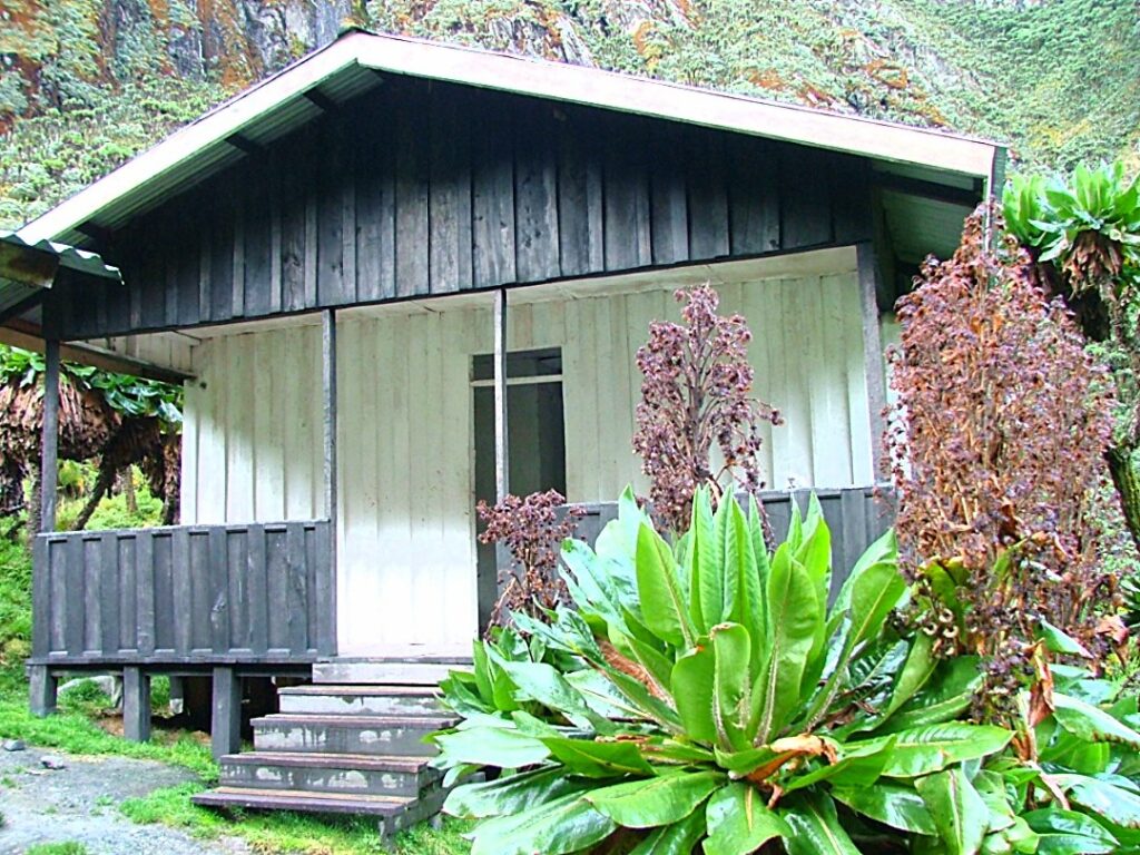
On the Central Circuit Trail, trekkers stay in a network of mountain huts at Nyabitaba, John Matte, Bujuku, Elena, Kitandara, and Guy Yeoman huts. The huts provide basic but adequate shelter, with mattresses provided, and the Elena Hut, at approximately 4,541 meters, immediately below the glaciated summit zone, is one of the most extraordinary places to spend a night anywhere in East Africa. The Kilembe Trail boasts well-maintained Kalalama, Mutinda, Bugata, Hunwicks, and Margherita camps, several of which feature solar panels for charging. For full details on options both inside and outside the park, our complete Rwenzori accommodations guide covers everything you need to know.
Would it be possible to trek the Rwenzori Mountains year-round?
Yes. You can trek the Rwenzori mountain peaks in any month, unlike some mountain ranges where parts of the year are genuinely inaccessible. The two dry seasons, December to February and June to September, offer the best trail conditions and highest summit probability. The wet seasons bring significant challenges in terms of trail conditions and summit visibility but are not impossible. We trek the Rwenzoris throughout the year and adjust itineraries, equipment, and camp choices based on current conditions.
What is the Rwenzori Mountains’ significance to local communities?
The Rwenzori Mountains are central to the cultural identity and spiritual worldview of the Bakonzo people, who have inhabited the mountain’s foothills for centuries. The Bakonzo call the mountains Rwenjura, a word that means “rain-beater” or “cloud-maker,” and regard the range as a living, sacred entity that provides the rain that sustains their crops and communities. The glaciers that feed the Mubuku and Bujuku rivers are considered holy water sources. Every trek in the Rwenzori Mountains is conducted in the context of this living cultural relationship, and we actively support Bakonzo community projects through a portion of every expedition fee.
Start Planning Your Rwenzori Mountain Peaks Expedition.
The Rwenzori mountain peaks are waiting. Not as a bucket-list checkbox, but as a transformative encounter with one of the most extraordinary mountain ranges on the planet, a place where the landscape itself changes every thousand meters of altitude gain, where glaciers still exist on the equator, and where the silence above 5,000 meters is the kind that recalibrates your understanding of what matters.
We have spent over a decade learning these mountains not from behind a desk, but from years of guiding trekkers of every level through every zone, in every season, to summits and saddles and valley floors that most people never see. We know which routes suit which ambitions, which weeks of the year give the best weather windows for the summit push, and how to build an itinerary that leaves you exhausted, elated, and profoundly glad you came.
If you are ready to begin planning your Rwenzori expedition, whether you have a clear vision or just the seed of one, get in touch with our team today. Tell us what you want from this mountain. We will be honest with you about what is achievable, realistic about what it costs and what it demands, and genuinely excited to help you design something worth everything it takes to get there.
You can also explore our full range of Rwenzori trekking itineraries and available routes to get a feel for the options. If you have specific questions not answered here, our FAQ page covers the most common queries in depth.
The Mountains of the Moon are real. And they are waiting for you.
ANY QUESTIONS?
If you need any clarification about a Rwenzori trek, contact one of our trekking experts to start planning your journey today.
A 10% percentage of your safari proceeds goes to supporting the local Bakonjo Communities (orphans, schools & homes)
Hi there, welcome. Need help planning a trek, safari, or adventure? Chat directly with a real expert and mountain guide for honest advice, clear answers, and practical recommendations. No guesswork, no pressure.