Complete guide to the 8-Day Cheptegei Peak Trek via the Kilembe Trail (4,907m). Day-by-day itinerary, camps, gear, difficulty & booking.
8-Day Cheptegei Peak Trek via Kilembe Trail | Rwenzori Mountains
8-Day Cheptegei Peak Trek via the Kilembe Trail: Complete Guide to Uganda’s Most Untouched High-Altitude Route
Cheptegei Peak (4,907 metres) stands as one of the Rwenzori Mountains‘ most rewarding and least-trodden summits. Rising on the Kilembe Trail, the southern approach to the range, it offers a genuinely different mountain experience from the crowded Central Circuit: wilder terrain, fewer expedition parties, a more demanding and self-reliant character, and a summit view that encompasses the full sweep of the Rwenzori massif from the Kilembe valley far below to the Stanley glacier fields to the north. The 8-Day Cheptegei Peak Trek via the Kilembe Trail is the definitive way to experience this extraordinary route in full, with enough days to acclimatize carefully, absorb the mountain’s singular ecology, and give yourself the best possible chance of standing on the summit.
The Kilembe Trail is the Rwenzori’s second major route, entering the mountain from the old copper-mining town of Kilembe on the range’s southwestern flank. Where the Central Circuit comes through a wide valley with a well-worn trail, the Kilembe Trail climbs through a narrower, steeper river gorge system with dramatic waterfalls, deep-cut valleys, and a series of completely different ecological zones. The Nyamwamba River roars alongside the lower trail. The heather moorland above Mutinda Camp is among the most atmospheric Afroalpine terrain in Africa. And the high-altitude approach to Cheptegei Peak crosses a landscape of glacial lakes, rock ridges, and ancient boulder fields that very few trekkers have ever witnessed.
Embark on an 8-day Rwenzori trek to Cheptegei Peak (4,907 m) via the scenic Kilembe Trail. Experience Uganda’s most pristine alpine landscapes with expert guides. Take the Untouched Trail of the Moon Mountains to the top of Cheptegei Peak in Uganda.
This 8-day trek via the Kilembe Trail will take you to Cheptegei Peak (4,907 m) in the Rwenzori Mountains, where you will feel like you are in another world. Rwenzori Trekking Services runs this route, which takes you through various habitats and high-altitude environments in a raw, immersive, and less-crowded way.


8-Day Cheptegei Peak Trek: At-a-Glance
| Duration | 8 Days / 7 Nights on the mountain |
| Total Distance | Approximately 80 km (50 miles) round trip |
| Maximum Elevation | 4,907m; Cheptegei Peak |
| Minimum Elevation | 1,463m; Kilembe Trailhead |
| Total Elevation Gain | Approx. 3,444m cumulative ascent |
| Difficulty | Strenuous; prior trekking experience strongly recommended |
| Trek Route | Kilembe Trail (out-and-back with loop variants) |
| Start & End Point | Kilembe Village Gate, near Kasese, Western Uganda |
| Summit Day | Day 6 (from high camp, approx. 4,500m) |
| Glacier Crossing | None. Cheptegei Peak is a non-glaciated rocky summit |
| Best Season | December–March and June–August (driest months) |
| Group Size | 2 to 12 trekkers (private departures available) |
| Accommodation | Mountain huts and basic shelters on the Kilembe Trail |
| Rubber Boots | Mandatory: deep mud and river crossings throughout |
| Porter Policy | Mandatory: 1 porter per trekker minimum |
| Price Indicator | From USD $1,750 per person |
Why Climb Cheptegei Peak via the Kilembe Trail? What Sets This Trek Apart.
The vast majority of Rwenzori trekkers head for Margherita Peak on the Central Circuit and for good reason. But that near-universal focus has left Cheptegei Peak and the Kilembe Trail in a state of benign neglect that experienced mountain travelers increasingly seek. Fewer than 300 trekkers per year complete the full Kilembe Trail to high altitude compared to the several thousand who attempt the Central Circuit. On the approach to Cheptegei, you may go entire days without encountering another expedition party. The solitude, the rawness of the trail, and the sense of genuine discovery are qualities that are increasingly rare in East African mountain trekking.
At 4,907 metres, Cheptegei Peak is a serious high-altitude objective that requires proper respect. It does not involve glacier crossing; the peak is a non-glaciated rocky summit, but its elevation places the summit approach firmly in the altitude zone where acclimatization is critical and where the physical demands on the body are substantially greater than any trekking below 4,000 metres. The 8-day schedule gives you the acclimatization profile needed to reach the summit safely: a gradual ascent through the lower forest and bamboo zones, a careful approach through the Afro-alpine moorland, a dedicated acclimatization day at the high camp, and a summit bid on Day 6 from a position of genuine physiological readiness. For comparison, the 8-day Kilembe Trail Margherita Peak Trek targets the higher Margherita Peak (5,109 m) on the same trail with the addition of a glacier crossing section.
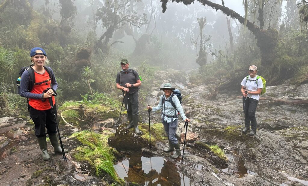
The Kilembe Trail’s ecological richness is extraordinary. Beginning in the transition zone between lowland savanna and montane forest at Kilembe village, the trail ascends through five distinct vegetation zones over eight days. You will walk through towering riverine forest alongside the Nyamwamba River, into ancient bamboo cathedral zones, across open Afro-alpine moorland dotted with giant lobelias and groundsel trees, and finally onto bare rock ridges at 4,500 metres where the wind is constant and the views reach from the Congo basin to Lake George. The Rwenzori’s vegetation zones are among the most biodiverse in Africa, and the Kilembe Trail accesses them in their least disturbed state.
The Kilembe Trail also passes through some of the most dramatic waterfall scenery in Uganda. The Nyamwamba River gorge on the lower trail, the multiple cascades near Samalira Camp, and the elevated moorland streams above Mutinda combine to create a landscape defined by moving water, which makes the trail both more visually spectacular and, frankly, wetter than the Central Circuit. Come prepared. Come with rubber boots. Come ready to completely absorb yourself in a mountain that asks everything of you and returns something rare.
Full Day-by-Day Itinerary: 8-Day Cheptegei Peak Trek via the Kilembe Trail
Day 1: Kilembe Village to Sine Camp
Sine Camp 2,350m | First Steps into the Rwenzori’s Southern World
Elevation: 1,463m to 2,350m (+887m) | Distance: ~7 km | Hiking Time: 4–5 hours
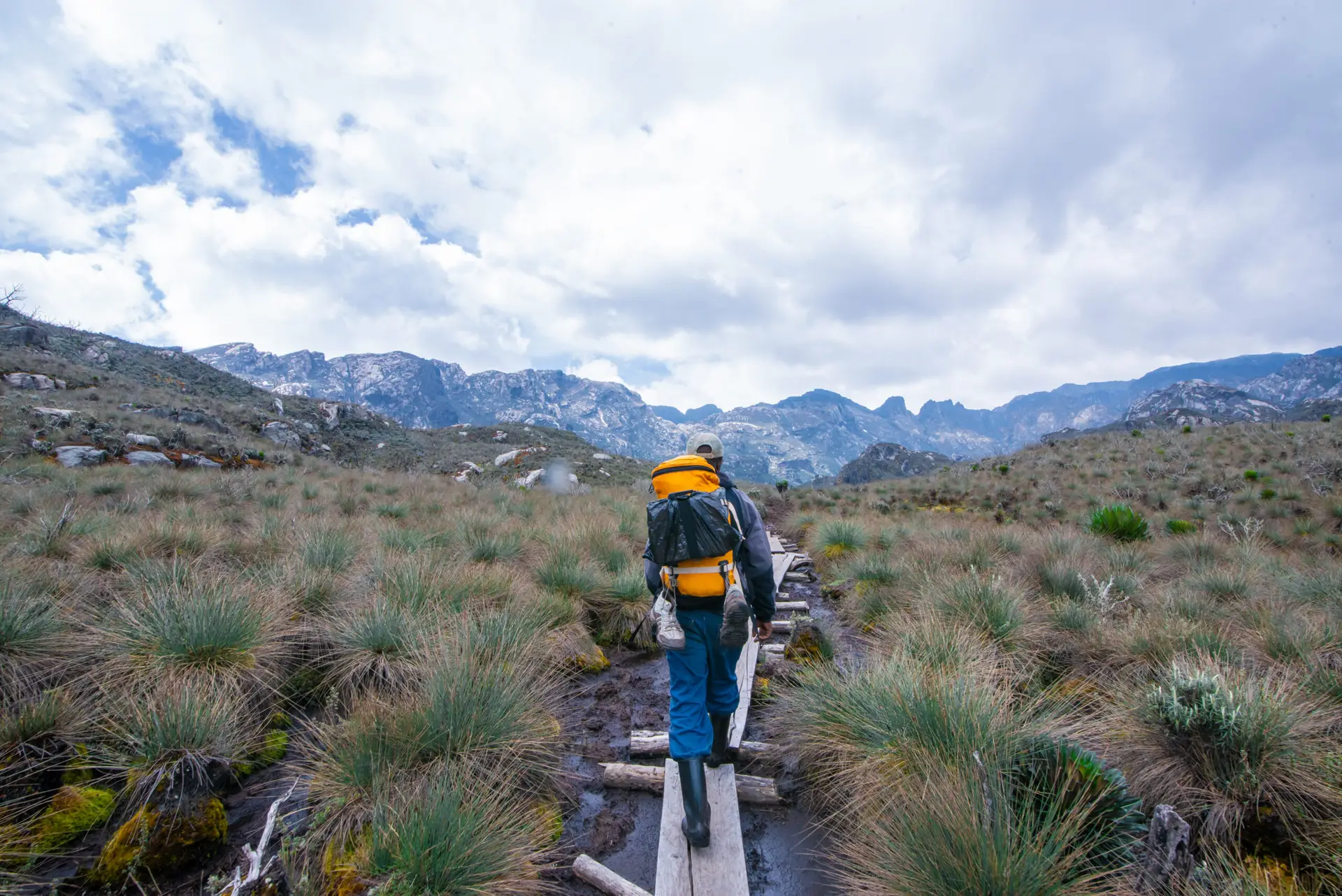
The 8-Day Cheptegei Peak Trek begins at Kilembe village gate (1,463 m), located approximately 12 kilometers from Kasese town along a well-maintained dirt road. Kilembe was once the center of Uganda’s copper mining industry, and the old mine infrastructure, rusting conveyors, and weathered headframes are visible as you register at the Uganda Wildlife Authority ranger post and meet your guide and porter team. It is a fittingly industrial start to a trek that will carry you from a human landscape into one of Africa’s most pristine alpine environments over the following eight days.
The trail enters the Nyamwamba River gorge almost immediately, climbing steeply through luxuriant riverine forest alongside the river’s right bank. The sound of the Nyamwamba, powerful, white, and constant, will be your companion for most of today’s walking. The forest at this elevation is visually lush: Ficus, Albizia, and Macaranga trees form the upper canopy, with a rich understory of wild gingers, balsams, and enormous ferns. The trail crosses the river twice on log bridges within the first hour, and the footing on both banks is typically muddy from the river’s splash zone.
The trail steepens steadily as you gain elevation, the forest gradually changing character as you leave the riverine zone and enter the lower montane forest proper. By the time you reach Sine Camp in the late morning or early afternoon, the vegetation around the camp has the first hints of the moss-draped character that will intensify dramatically over the next three days. Sine Camp is a comfortable hut at 2,350 metres with sleeping platforms, a cook shelter, and stream water nearby. The afternoon is for rest, drying clothes, and an early dinner. The views from the camp clearing look back toward Kilembe and the Kasese plain below.
Guide Insight: Day 1 River CrossingsUWA maintains the log bridges over the Nyamwamba in the lower gorge, but they can be genuinely slippery when wet, which is almost always. Take them slowly, one trekker at a time, using your trekking pole for balance. Your porter will cross first to demonstrate the line. The river itself is not dangerous at the crossing points, but a fall onto wet logs is unpleasant. Rubber boots provide the best grip on log surfaces. |
Day 2: Sine Camp to Samalira Camp
Samalira Camp: 2,700 m | Waterfalls, Bamboo and the First Heather World
Elevation: 2,350 m to 2,700 m (+350 m) | Distance: ~8 km | Hiking Time: 5–6 hours
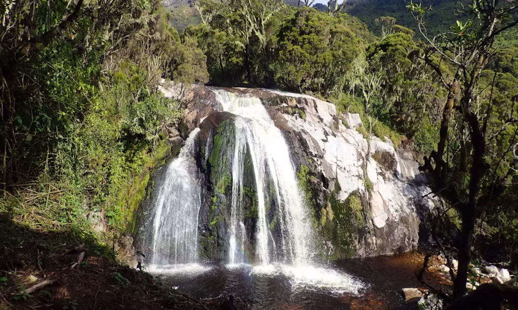
Day 2 is the most scenically dramatic of the lower mountain days and the section that cements the Kilembe Trail’s reputation as the Rwenzori’s most visually spectacular approach. The trail climbs from Sine Camp through a bamboo zone that becomes progressively denser as you gain altitude, transitioning into the ancient giant heather forest by mid-morning. Multiple waterfalls are audible from the trail, and several are directly visible, cascading off the rocky faces above the Nyamwamba gorge in wide, foaming curtains. This is one of the finest waterfall sections in Uganda, and if you are a photographer, budget extra time here.
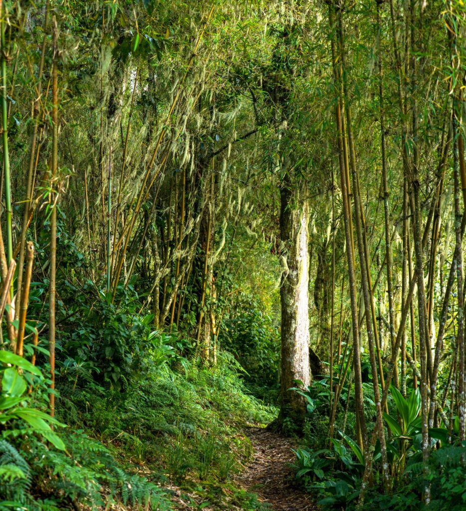
The bamboo zone between 2,400 and 2,600 metres is a particular highlight. Giant mountain bamboo (Sinarundinaria alpina) forms dense stands on both sides of the trail, the culms arching overhead to create natural tunnels of pale green light. The floor beneath is carpeted with fallen bamboo leaves, soft and springy underfoot, and the sound of rustling in the upper bamboo from the wind or wildlife is constant. You can regularly see black-and-white colobus monkeys in the bamboo canopy here; listen for the deep territorial roar of adult males carrying through the valley.
By the time you reach Samalira Camp (2,700 m) in the early afternoon, the forest has shifted decisively into the heather zone. Erica arborea trees clad entirely in thick hanging moss and lichen flank the camp clearing. The camp itself sits on a relatively flat section of trail with a stream crossing just below. The hut is similar to Sine Camp in design, with sleeping platforms and a cook area. Temperatures at Samalira are noticeably cooler than in Sine; expect 10–14 degrees Celsius during the day and 6–8 degrees overnight. After dinner, listen for the Rwenzori nightjar calling from the heather trees above the camp.
Highlight: Kilembe WaterfallsThe waterfall section between Sine and Samalira camps on Day 2 is one of the signature visual experiences of the entire Kilembe Trail. The largest falls drop more than 40 metres off the valley walls directly above the trail. In the dry season months, they remain powerful; after heavy rain, they become extraordinary. The best photography position is approximately 2 hours from Sine Camp, where the trail briefly opens onto a viewpoint facing the main cascade. Ask your guide to stop here. |
Day 3: Samalira Camp to Mutinda Camp
Mutinda Camp 3,535m | Into the Afroalpine: Giant Groundsels and Open Moorland
Elevation: 2,700m to 3,535m (+835m) | Distance: ~10 km | Hiking Time: 6–7 hours
Day 3 is the most physically demanding day of the lower mountain section and the day that delivers you from the heather forest world into the extraordinary Afroalpine moorland that defines the upper character of the Rwenzori. The trail climbs 835 metres over approximately 10 kilometers, not extreme by mountain standards but sustained, with several steep sections on a rocky, root-covered trail that require careful footwork. Plan an early departure (7:00am at the latest) to ensure a comfortable arrival at Mutinda before afternoon cloud build.

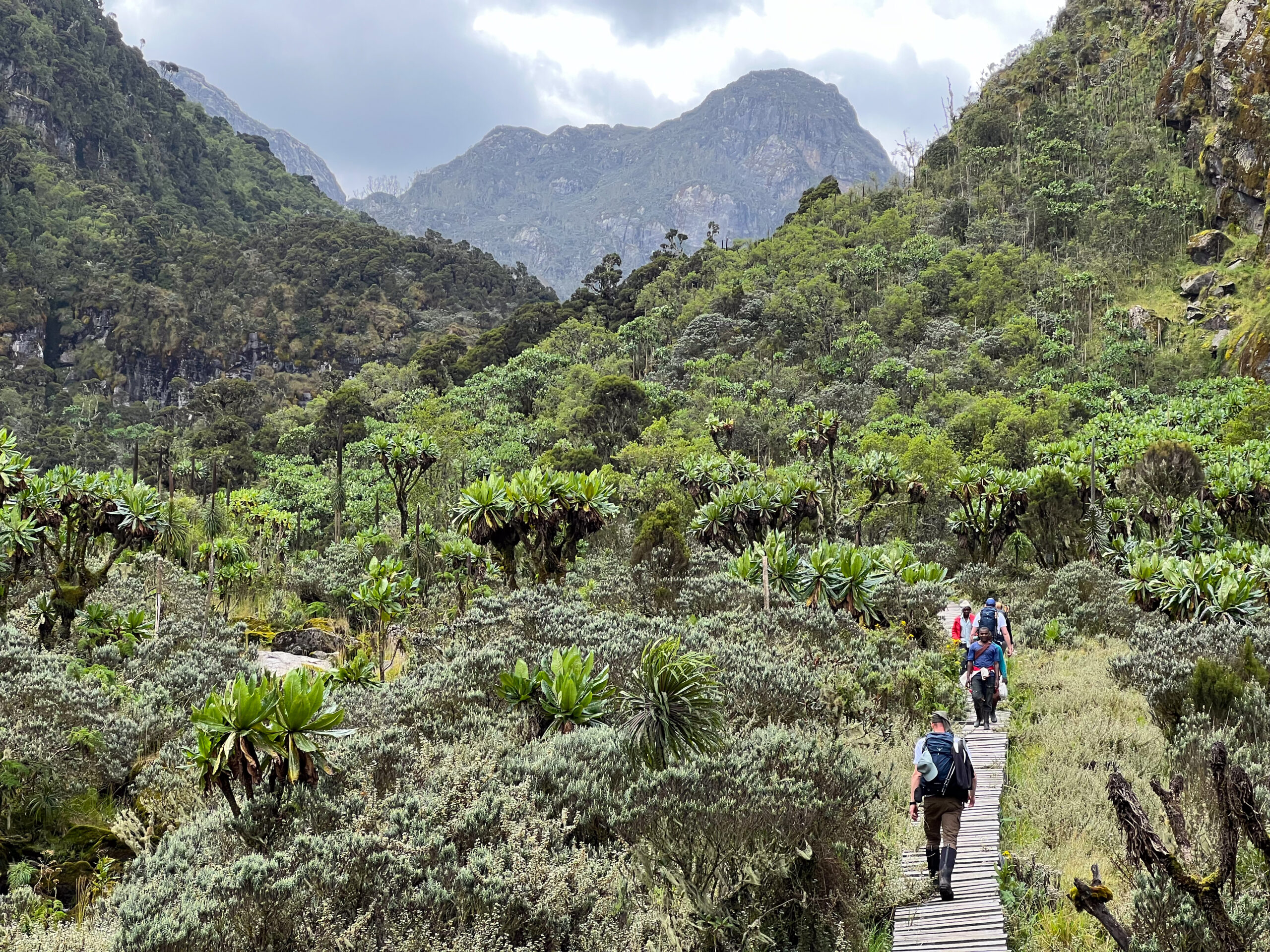
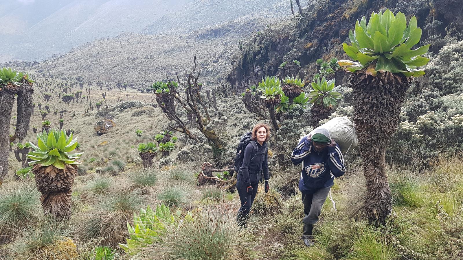
The first two hours from Samalira continue through dense heather forest, the trees gradually decreasing in height and increasing in moss coverage as altitude increases. At around 3,000 metres, the forest opens abruptly into the open Afro-alpine moorland that characterizes the mid-mountain section of the Kilembe Trail. The change is visually dramatic: from enclosed forest to open sky, from filtered light to full sun (when it shines), from the sound of forest birds to wind and the distant sound of the Nyamwamba far below. The first giant groundsel trees (Senecio adnivalis) appear here, standing 3–4 metres tall in scattered groups, their thick cabbage-like rosettes of leaves unmistakable against the sky.
The trail across the moorland above 3,000 metres is the section where rubber boots earn their full justification on the Kilembe Trail. The Afro-alpine peat bogs of the Rwenzori are legendary among mountain trekkers: deep, cold, and relentless. Duckboards and stepping stones mark the worst sections, but between them the trail is simply soft, wet peat that will swallow a conventional trekking boot to the ankle. Mutinda Camp (3,535 m) sits on a prominent lookout ridge above the moorland with the finest panoramic views of the route on clear days; the Kasese Valley, Lake George, and the distant Queen Elizabeth National Park plains are all visible below.
Warning: Altitude at Mutinda CampAt 3,535 m, Mutinda is high enough that mild altitude symptoms, headache, reduced appetite, and slight nausea are common on arrival, particularly for trekkers who have gained significant elevation rapidly over three days. Drink at least 3–4 liters of water throughout Day 3. Report any symptoms to your guide immediately. The full acclimatization guide on our website provides detailed information on recognizing and managing altitude effects on the Kilembe Trail. |
Day 4: Mutinda Camp to Bugata Camp
Bugata Camp 4,062m | Deep into the Rwenzori High Country
Elevation: 3,535m to 4,062m (+527m) | Distance: ~8 km | Hiking Time: 5–6 hours
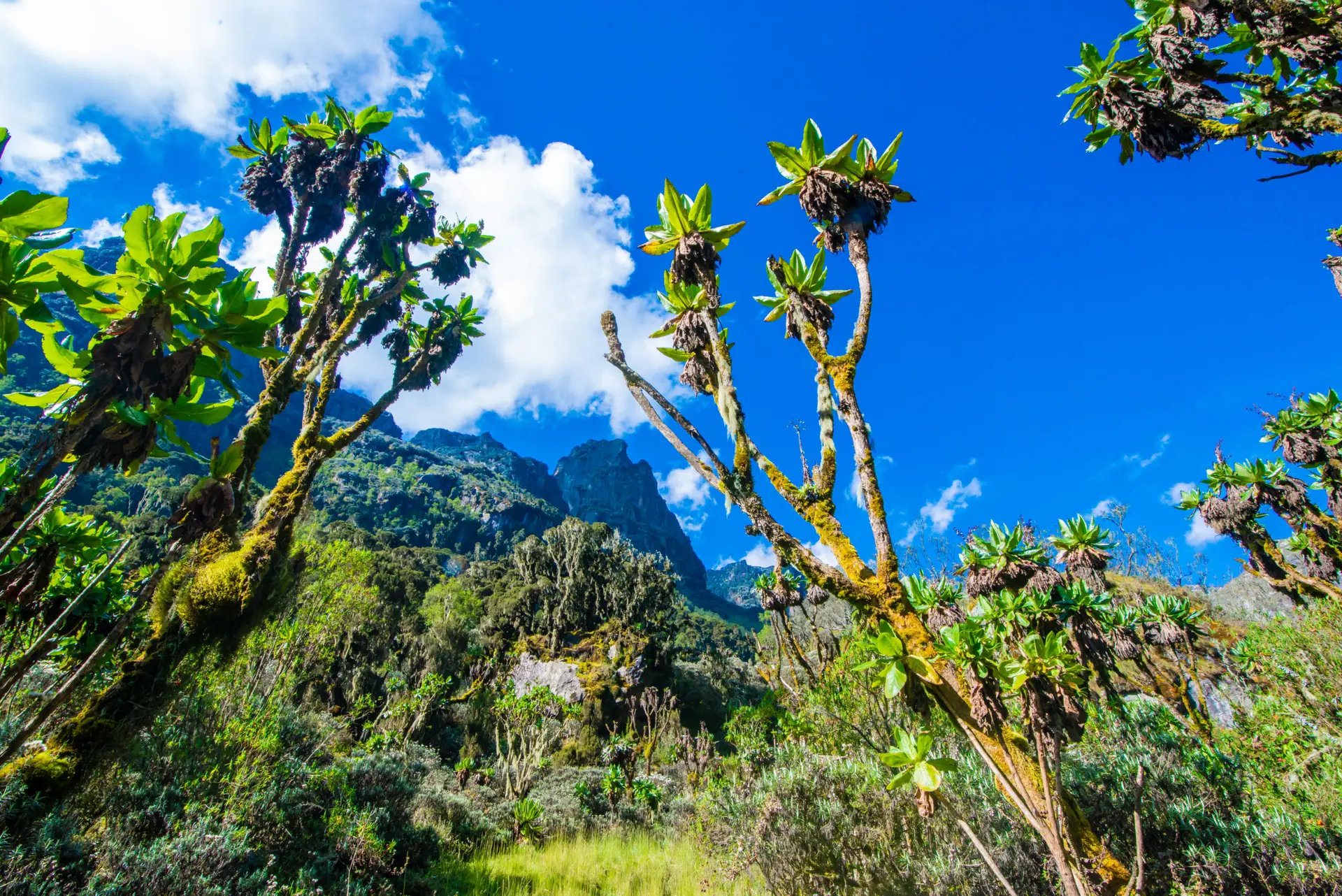
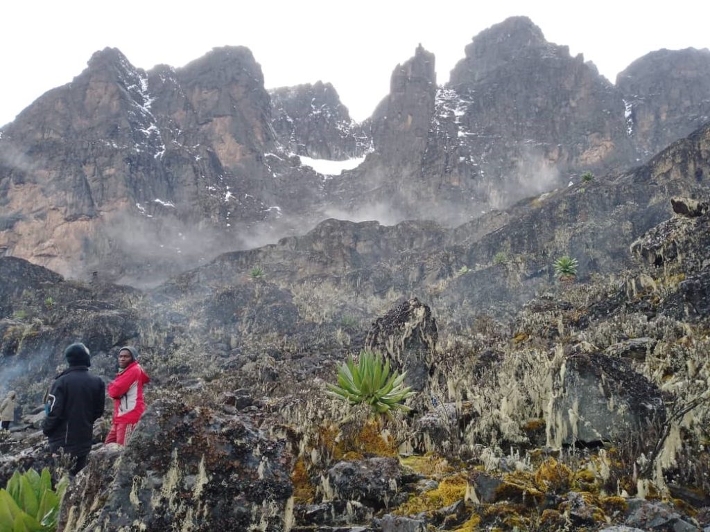
Day 4 carries you above 4,000 metres for the first time on the trek, a significant physiological threshold that separates the Kilembe Trail’s mid-mountain experience from its high-altitude character. The trail from Mutinda climbs through the upper moorland zone, passing through progressively more open terrain as vegetation becomes sparser and more frost-tolerant. The giant lobelias (Lobelia wollastonii) reach their most spectacular development on this section of the trail; individual plants stand 4–5 metres tall, their flower spikes rising like dark green candelabras above the surrounding heather, with the ice-capped Rwenzori ridgeline visible behind them on clear mornings. This area is the photographic heart of the trek.

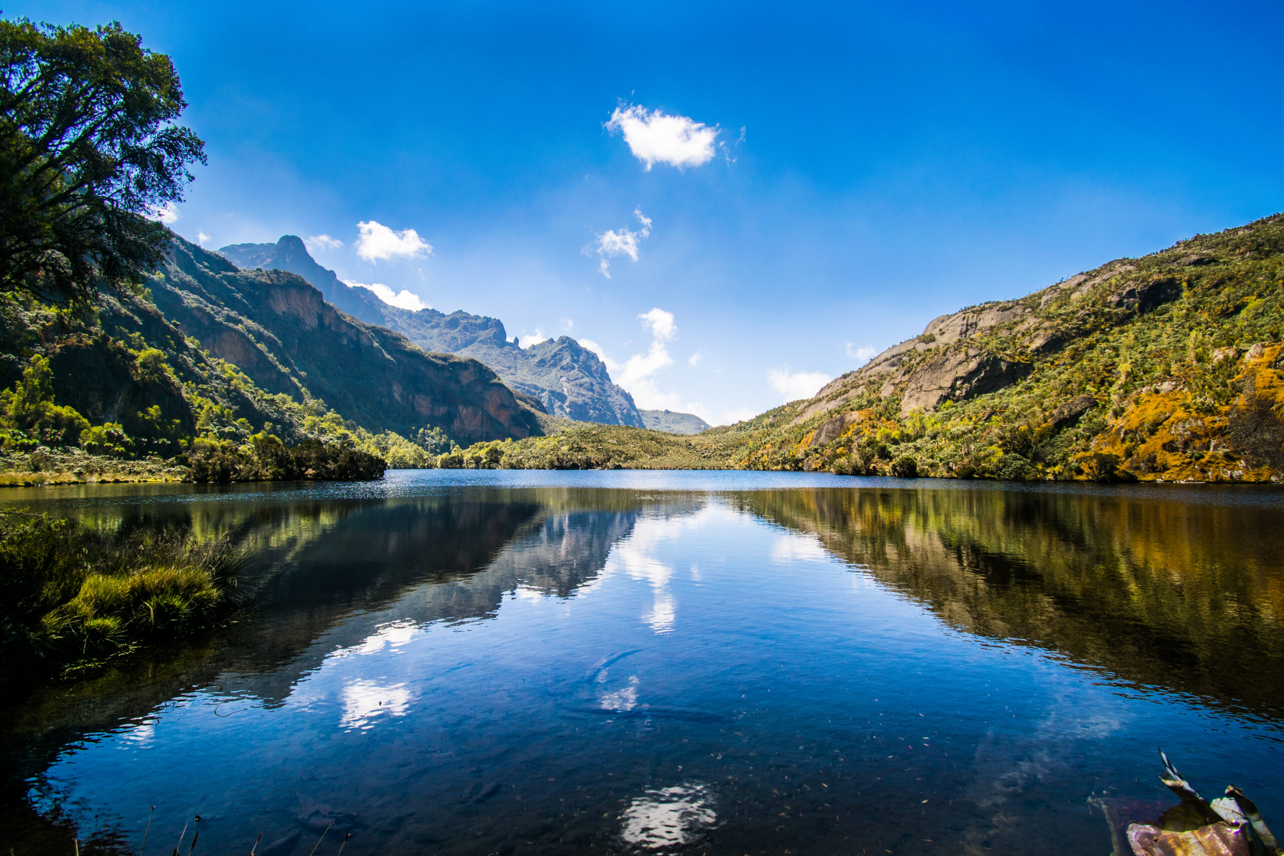
Above the lobelia zone, the trail enters a boulder field section that demands careful navigation. The rock here is the ancient gneiss and granite of the Rwenzori basement, dark, water-worn, and covered in bright orange lichen above the waterline. The footing is demanding but not technically difficult. Your guide will set a controlled pace. At around 3,900 metres, the trail crosses a small glacial lake system; several small tarns reflect the sky in dark, still surfaces before the final climb to Bugata Camp on a flat, sheltered terrace above the lakes.
Bugata Camp (4,062 m) is the highest established camp on the Kilembe Trail below the summit zone. The hut here is simpler in construction than the lower camps, a metal-frame structure with sleeping platforms and a basic cooking area. Views from the camp are outstanding in all directions: the Nyamwamba valley drops precipitously to the west, the bulk of the Rwenzori massif rises to the north, and on obvious days the Virunga volcanoes on the Congo horizon are visible to the southwest. Temperatures at Bugata drop to 0–4 degrees Celsius overnight. After the altitude gain of Day 4, a long sleep and generous hydration before Day 5 are the most important preparations for the summit.
Guide Insight: Bugata Camp PreparationThe evening at Bugata is the time for honest assessment. How is your body responding to altitude? Are you sleeping, eating, and drinking normally? Mild headache and reduced appetite are expected. Confusion, loss of coordination, or shortness of breath at rest are serious symptoms requiring immediate descent. Brief your guide fully on how you feel. Our summit bid success depends on honest communication at this camp more than at any other point on the route. |
Day 5: Bugata Camp to High Camp. (Acclimatisation Day)
High Camp approx. 4,500m | The Critical Altitude Night Before the Summit
Elevation: 4,062m to ~4,500m (+438m) | Distance: ~5 km | Hiking Time: 3–4 hours + rest afternoon
Day 5 is the acclimatization day that makes the 8-day schedule meaningfully safer than any compressed version of this itinerary. The objective is simple: move to the high camp at approximately 4,500 metres, rest completely for the afternoon, eat a full hot dinner, and sleep as well as altitude allows before the 4:00am summit wake-up call. The short distance covered today is intentional; the day is not a rest day in the sense of doing nothing, but a targeted physiological preparation for the summit push.
The trail from Bugata to the high camp crosses the upper boulder zone and gains the final ridge system that forms the approach to Cheptegei Peak. The terrain becomes increasingly stark and beautiful: no trees, minimal vegetation, just lichen-crusted rock, scattered cushion plants, and the immensity of the mountain sky above. If conditions are clear on the approach, you will have your first full view of the Cheptegei summit pyramid from the high camp position, a rocky, angular peak rising against the blue at 4,907 metres, and it is unmistakably close now after five days of approach.
After establishing camp at high camp and drinking a hot lunch, spend the afternoon resting genuinely. No exploration, no photography hikes. Lie down, keep warm, drink steadily, and let your body complete as much acclimatization as five days of gradual ascent allow. Your guide will give a full summit brief in the late afternoon: route conditions, gear checks, crampon inspection (not needed on Cheptegei’s rocky summit, but poles and gaiters are essential), expected departure time, and turnaround protocols. Be in your sleeping bag with your summit kit ready by 8:00pm.
Summit Briefing ChecklistBefore sleeping at high camp, confirm the following: The headtorch is functional with spare batteries; warm layers are accessible at the top of your pack; water bottles are filled and insulated; snacks are in outer pockets, poles are gripped correctly, and guide emergency contacts are confirmed. Wake-up is 3:30am. Departure is 4:00am sharp. |
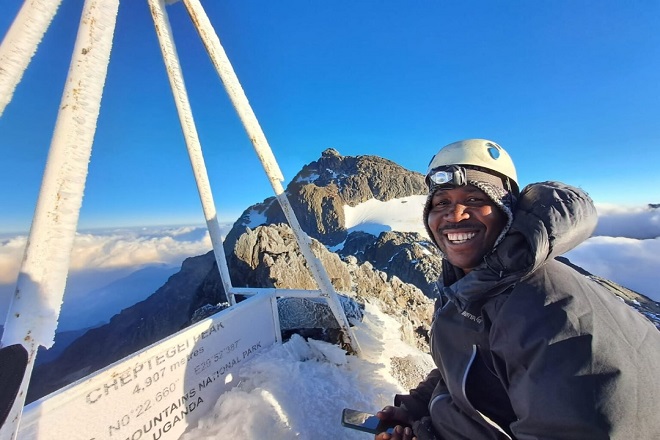
Day 6: Summit Cheptegei Peak (4,907m) (Full Summit Day)
Cheptegei Peak (4,907 m) | The Summit of the Untouched Trail
Elevation: ~4,500 m to 4,907 m (+407 m), then descent to Bugata (4,062m) | Distance: ~12 km | Hiking Time: 9–11 hours total
The summit alarm sounds at 3:30am. In the thin, cold darkness above 4,500 metres, this moment has a particular quality: the silence is absolute, the cold is penetrating, and the sky above the open ridge, if the night is clear, is blazing with stars at an altitude where light pollution does not exist. Dress in all your warm layers. Drink the hot tea your cook team will have ready. Check your headtorch. By 4:00am, the team is moving.
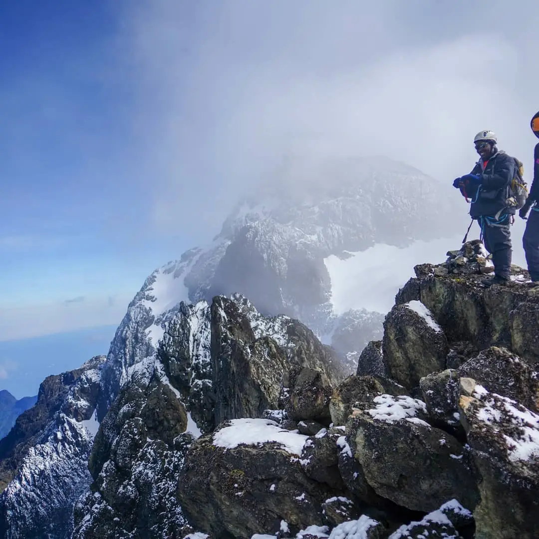
The pre-dawn ascent from high camp to the Cheptegei summit follows the ridge trail northward, climbing steeply in the darkness over rocky ground. The headtorch beams illuminate the path immediately ahead, and the wider darkness makes the mountain feel vast and close simultaneously. The first significant challenge is a sustained boulder-field section at approximately 4,600 metres where the trail requires careful route-finding that your guide will navigate instinctively from the many times they have done this climb. Above the boulder field, the ridge narrows and the angle eases briefly before the final pyramid approach.

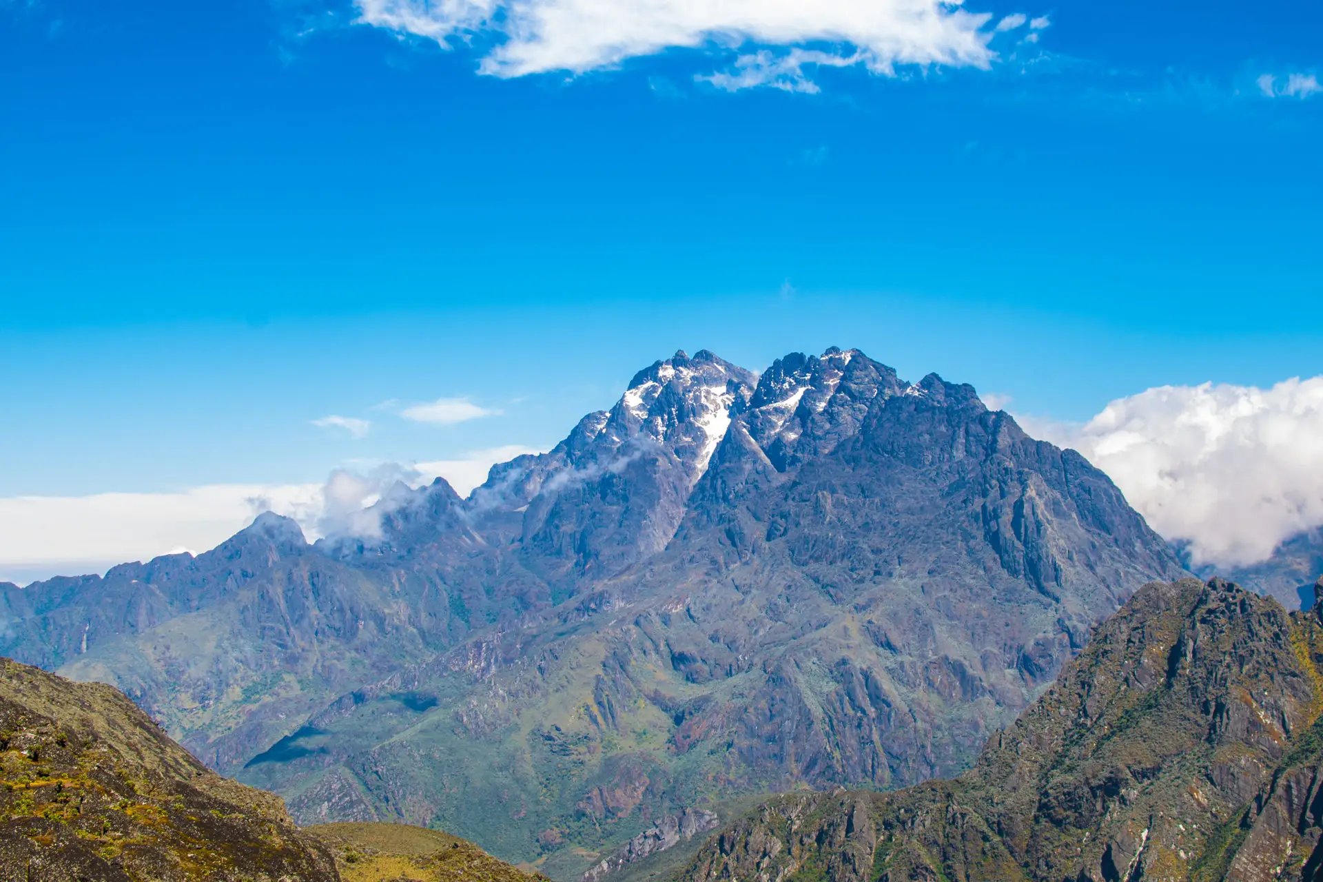
The summit pyramid of Cheptegei Peak is a series of rocky steps rather than a single dramatic face. Your guide will lead the team up the clearest line, which changes with seasonal ice and frost on the rocks. In the dry season months, the final approach is straightforward technical scrambling; in the wet season, some sections require extra caution on wet rock. By approximately 7:00–8:00am, three to four hours from high camp, the team arrives on the summit at 4,907 metres. The view from Cheptegei on a clear morning is one of the finest in the entire Rwenzori range: the full Stanley massif to the north, Mount Baker and the Freshfield Pass to the east, the Kilembe valley plunging 3,400 metres below to the west, and the immensity of the Congolese forest on the horizon.
Allow at least 20–30 minutes on the summit for photographs, for the genuine emotional satisfaction of the achievement, and to absorb a view that very few people on earth have ever seen. The descent from Cheptegei to Bugata Camp takes approximately 5 hours via the reverse of the ascent route, with an early-afternoon arrival allowing time for food, rehydration, and the deep sleep that summit night invariably delivers.
Warning: Summit Safety ProtocolCheptegei Peak is a non-glaciated summit, but at 4,907 m, the risks of altitude sickness, exposure, and navigational error in poor visibility are real. Your guide makes all decisions about summit push timing, turnaround conditions, and descent protocol. Turnaround time is 10:00am regardless of progress. Do not argue with this limit. Emergency descent procedures are briefed at high camp the evening before. Read the full safety guide on our website before departure. |
Day 7: Bugata Camp to Samalira Camp. (The Great Descent Begins)
Samalira Camp: 2,700 m | Dropping 1,362m Through Lobelia Fields and Heather Forest
Elevation: 4,062m to 2,700m (-1,362m) | Distance: ~15 km | Hiking Time: 6–8 hours
Day 7 is a long, sustained descent that carries you from the high-altitude world above 4,000 metres back through the full sequence of vegetation zones to Samalira Camp at the edge of the heather forest. After the physical and emotional intensity of summit day, there is a particular pleasure in this reversal: watching the landscape fill in as you lose altitude, feeling the air thicken, seeing the first mossy heather trees reappear, and hearing the forest birds resume their calls as you descend below 3,000 metres.
From Bugata Camp, the trail retraces the Day 4 approach through the boulder fields and upper moorland. The descent through the giant lobelia zone in morning light is extraordinarily beautiful: the lobelia spikes backlit by the rising sun, the dew still on the cushion plants, and the Kilembe valley visible below through gaps in the morning mist. Take your time on this section. The return journey through terrain you have already climbed always reveals details you missed on the way up, particularly in the botanical richness of the Afroalpine moorland.
Mutinda Camp is a natural lunch stop at the halfway point of the day, with its panoramic views providing a final elevated perspective before the trail drops below the treeline. The heather forest zone on the descent seems richer and darker than on the ascent; the light is different in the afternoon, the moss more saturated, and the tree forms more dramatic when seen descending into them rather than climbing through them. Samalira Camp provides a comfortable final night in the forest, with a temperature that feels luxuriously warm compared to the previous three nights spent above 3,500 metres.
Guide Insight: Day 7 KneesThe Day 7 descent is over 1,300 vertical metres on a trail that is steep, rooted, and muddy in its lower sections. Trekking poles are essential; without them, the impact on knees and hips over 6–8 hours of downhill walking is significant. If you have any history of knee problems, mention your condition to your guide at the pre-trek briefing. Pace the descent carefully and stop for 10 minutes every 90 minutes to let the joint fluid redistribute. |
Day 8: Samalira Camp to Kilembe Village. (Completing the Trek)
Kilembe Village Gate (1,463 m) | Out of the Mountain World
Elevation: 2,700 m to 1,463 m (-1,237 m) | Distance: ~12 km | Hiking Time: 5–6 hours
The final day of the 8-Day Cheptegei Peak Trek completes the descent through Sine Camp and back to Kilembe village. After seven days immersed in the mountain world, the lower forest on Day 8 has a quality that is difficult to describe: familiar but transformed by the perspective of having seen what lies above it. The Nyamwamba Gorge, with its churning river and riverside forest, now feels like a gentle re-entry into the inhabited world rather than the dramatic threshold it was on Day 1.
The trail descends from Samalira through the bamboo belt and back into the riverine forest alongside the Nyamwamba. The waterfalls that were so spectacular on Day 2 pass again in reverse; they have lost none of their drama. At Sine Camp, the team stops for a final trail lunch before the last 7-kilometer section to Kilembe village. The log bridges over the Nyamwamba, slippery and muddy on Day 1, are navigated now with the casual confidence of trekkers who have been on much harder terrain.
Visitors typically arrive at Kilembe Gate in the early to mid- afternoon. Uganda Wildlife Authority rangers issue trek completion certificates. Your transfer vehicle back to Kasese is waiting. The guides and porters who have accompanied you for eight days through some of the most extraordinary mountain terrain in Africa deserve a genuine thanks and a considered tip. Our porter services and tipping guide covers appropriate gratuity levels for the Kilembe Trail crew. Most trekkers find that the Kasese overnight before onward travel is welcome, even expected; legs need a flat surface and a warm bed.
Guide Insight: The Last DayDay 8 is often the most emotionally complex day of the trek. There is genuine satisfaction at completion, and often an unexpected reluctance to leave. The mountain has that effect. If you have the time, consider staying an extra night in Kasese and visiting the Rwenzori Mountaineering Services museum in Kilembe to see historical expedition photographs and equipment. It puts the route you have just completed into a longer human context that enriches the experience considerably. |
Elevation Profile: 8-Day Cheptegei Peak Trek via Kilembe Trail
| Day / Section | Elevation Range | Net Change |
| Day 1: Kilembe – Sine Camp | 1,463 m to 2,350 m | +887 m gain |
| Day 2: Sine – Samalira Camp | 2,350 m to 2,700 m | +350 m gain |
| Day 3: Samalira – Mutinda Camp | 2,700 m to 3,535 m | +835 m gain |
| Day 4: Mutinda – Bugata Camp | 3,535 m to 4,062 m | +527 m gain |
| Day 5: Bugata – High Camp | 4,062 m to ~4,500 m | +438 m gain |
| Day 6: Summit Cheptegei back to Bugata | 4,500 m to 4,907 m, then 4,062 m | +407 m / -845 m |
| Day 7: Bugata – Samalira Camp | 4,062 m to 2,700 m | -1,362 m descent |
| Day 8: Samalira – Kilembe | 2,700 m to 1,463 m | -1,237 m descent |
| TOTALS | Peak: 4,907 m (Cheptegei) | +3,444 m up / -3,444 m down |
The elevation arc of the 8-Day Cheptegei Peak Trek is notably more gradual in its ascent profile than the compressed summit itineraries on the Central Circuit. The first three days average 690 m of gain per day, a healthy acclimatization rate that allows the body to adapt progressively. Days 4 and 5 slow the rate further as altitude increases, with Day 5 specifically functioning as a limited-gain acclimatization day at high camp. The summit push on Day 6 adds only 407m from the high camp position, making the actual ascent on summit morning significantly less demanding than summit days on routes that require the full elevation gain from a lower camp.
Camps & Accommodation on the 8-Day Cheptegei Peak Trek
All overnight camps on the Kilembe Trail are Uganda Wildlife Authority facilities. The full mountain huts guide covers facilities across all Rwenzori trails. Below are the specific camps used on the 8-Day Cheptegei itinerary.
Sine Camp, 2,350 m (Night 1 and Night 7)
Sine Camp is the first overnight stop on the Kilembe Trail and sits at the edge of the heather transition zone in a sheltered forest clearing. The metal-frame hut provides sleeping platforms for up to 10 trekkers, with a separate cooking shelter and a stream water source 50 metres below camp. The camp position offers filtered views down toward the Nyamwamba gorge. Temperatures are mild by Rwenzori standards, 14–18 degrees during the day and 10–12 overnight, making it the warmest night camp on the itinerary. The camp makes an ideal final-night stop on the descent, warm and comfortable after the demanding high-altitude sections above.
Samalira Camp, 2,700 m (Nights 2 and 6)
Samalira sits at the upper edge of the heather forest zone, a short distance above a series of waterfalls that are audible from the camp clearing on still days. The hut design is similar to Sine Camp. The waterfall proximity means the air at Samalira is perpetually moist and slightly cooler than the temperature alone suggests; a fleece layer is appropriate after sunset even in the dry season. The camp is one of the best birdwatching positions on the entire Kilembe Trail, with the heather-forest transition zone providing habitat for a dense assemblage of Albertine Rift endemic bird species.
Mutinda Camp, 3,535 m (Day 3 pass-through lunch stop only on 8-day schedule)
Mutinda functions as a lunch stop rather than an overnight camp on the 8-day Cheptegei itinerary, though it can be used as an overnight on other itinerary variants. The camp occupies a prominent moorland ridge with panoramic views, the most visited viewpoint on the Kilembe Trail, and the standard photography stop for lower-altitude trekkers. On clear days, the views from Mutinda extend south to Lake George and west toward the Congo.
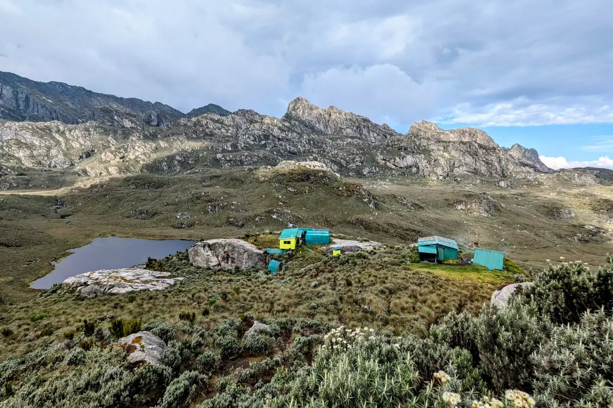
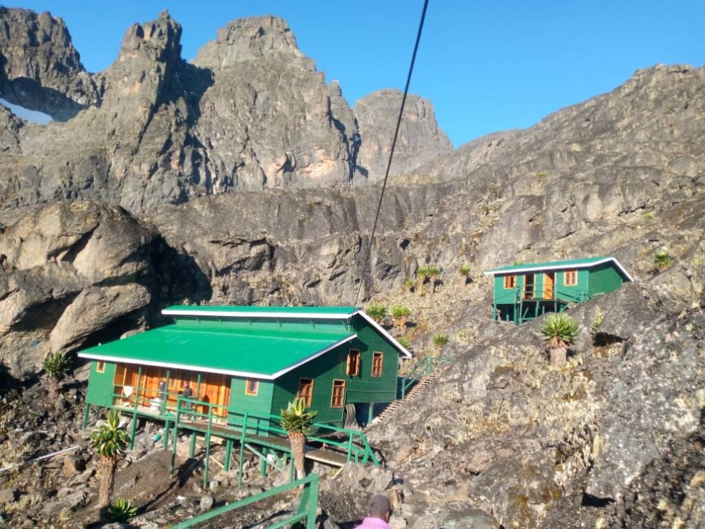
Bugata Camp, 4,062 m (Nights 3 and 5)
Bugata is the highest established camp facility on the standard Kilembe Trail and the key acclimatization point before the high camp and summit. The hut here is more basic than the lower camps, a single metal-frame structure with sleeping platforms and limited cooking shelter. Temperatures at Bugata drop to 0–4 degrees Celsius overnight, and frost on the tent fly or hut roof is common in clear-sky conditions. The camp’s high position on a flat terrace above the glacial lake system provides extraordinary views in all directions, particularly toward the Rwenzori’s central massif to the north. Water is sourced from the glacial tarns below camp.
High Camp approx. 4,500 m (Night 4)
The high camp is established at approximately 4,500 metres on the rocky ridge below the Cheptegei summit pyramid, using lightweight tents and sleeping mats that are carried by the porters. This is the coldest overnight position of the entire trek. Temperatures drop to minus 5 to minus 10 degrees Celsius on clear nights, and the wind at this exposed elevation can be significant. A sleeping bag rated to -10 degrees Celsius is required. The high camp position provides the first unobstructed view of the Cheptegei summit and, on clear evenings, a sunset over the Rwenzori that rewards every difficult step of the preceding days.
Flora & Wildlife on the 8-Day Cheptegei Peak Trek
The Kilembe Trail traverses all five of the Rwenzori’s major vegetation zones across eight days, making the 8-Day Cheptegei Peak Trek one of the most botanically complete routes on the mountain. Each zone transition is sudden and visually striking, and the complete sequence from tropical riverine forest to high Afroalpine rock shows one of the most compressed altitudinal botanical gradients in Africa.
Zone 1: Riverine Forest (1,463 m-2,000 m)
On Days 1 and 8, tall tropical forest species dominated the lowest zone alongside the Nyamwamba River. Key trees include Ficus species, Macaranga kilimandscharica, and Polyscias fulva. This is prime habitat for olive baboons, black-and-white colobus monkeys, and a wide diversity of forest birds, including African fish eagles over the river.
Zone 2: Montane Forest & Bamboo (2,000 m-2,800 m)
The heather-bamboo transition zone on Days 2–3 is the richest section for birdwatching on the entire route. Target species include the Rwenzori turaco (Ruwenzorornis johnstoni), Doherty’s bushshrike, Rwenzori batis, white-starred robin, and Rwenzori apalis. First-time visitors frequently encounter three-horned chameleons (Trioceros johnstoni) on tree trunks in this zone, making them a consistent highlight.
Zone 3: Giant Heather Moorland (2,800 m-3,500 m)
Ancient Erica arborea and Philippia benguelensis trees, draped entirely in hanging lichen and deep moss cushions, line both sides of the trail through this zone. Individual trees accumulate 20–30 kilograms of living epiphytic material. Hyrax colonies occupy rocky outcrops throughout the zone and often make loud sounds that can be heard from camp at night.
Zone 4: Afroalpine Moorland (3,500 m-4,400 m)
Giant groundsels (Senecio adnivalis, up to 5m tall) and giant lobelias (Lobelia wollastonii, to 5m) dominate the open moorland above Mutinda Camp. These prehistoric-looking plants grow only in the Afroalpine zone of equatorial African mountains and reach their most dramatic expression in the Rwenzori. People occasionally see Rwenzori leopard tracks in the soft peat of the moorland, but most people do not encounter them. Augur buzzards circle overhead on thermal currents above the open ground.
Zone 5: High Alpine Rock (4,400 m+)
Above the lobelia zone, vegetation reduces to scattered cushion plants (Alchemilla argyrophylla), frost-adapted moss, and extensive lichen communities on the rock faces. At this altitude, the only reliable wildlife is the Cape long-tailed starling, occasionally seen near the high camp, and various high-altitude invertebrates in rock crevices.
Physical Difficulty & Fitness Requirements
The 8-Day Cheptegei Peak Trek via the Kilembe Trail is rated strenuous, one category below the very strenuous rating of the compressed summit itineraries, but it is demanding enough to require prior trekking experience for safe completion. The 8-day schedule provides an excellent acclimatization profile, but the cumulative distance (approximately 80 km), the total elevation gain (3,444 m), and the sustained nature of the terrain (muddy, root-covered, and technically demanding throughout) mean that this trek rewards preparation and punishes complacency.
Trekkers who are well-suited to this itinerary can honestly answer yes to all of the following: You have completed at least one multi-day trek of 3 or more days. You can walk 8–10 kilometers per day carrying a 10 kg daypack. You have some experience at altitudes above 3,000 metres. You are comfortable on steep, muddy terrain. You do not let wet conditions deter you and can manage physically demanding days even in rain. Our complete fitness and training guide provides a detailed 12-week preparation program specifically designed for Rwenzori trekkers.
At 4,907 metres, Cheptegei Peak reaches the altitude zone where acclimatization is a serious consideration. The 8-day schedule is designed to provide adequate acclimatization time, gaining altitude gradually over five days before the summit push, but individual responses to altitude vary significantly. Our full acclimatization guide and comprehensive medical guide both contain essential information for high-altitude trekking preparation. Discuss altitude medication (acetazolamide/Diamox) with your doctor before traveling.
Trekkers over 50 and those with any cardiovascular or respiratory health history should read our guide for older hikers on the Rwenzori and consult their doctor before committing to this itinerary. The 8-day schedule is the minimum length we recommend for anyone targeting Cheptegei Peak; do not attempt to compress it further without prior high-altitude experience above 4,500m.
Best Time to Trek the Kilembe Trail to Cheptegei Peak.
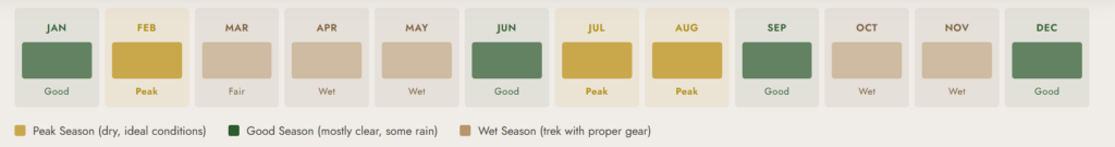
The Kilembe Trail is wetter than the Central Circuit throughout the year due to its southwest-facing aspect and the orographic effect of the Nyamwamba drainage system. Even in the dry season, expect some rain on this route; the mountain makes its own weather. Our complete best time to visit guide covers the full seasonal picture. The table below reflects conditions specifically relevant to the Kilembe Trail.
| Month | Kilembe Trail Conditions |
| December – February | Best conditions. Relatively dry. Clear summit views. Recommended. |
| March | Transitional. Increasing afternoon showers. Generally good. |
| April – May | Heavy rains. The trails are deeply muddy. Waterfall crossings are higher risk. |
| June – August | Second dry season. Excellent. Clear days are common at altitude. |
| September – October | Transitional. Variable. Expect wet afternoons and some all-day rain. |
| November | Short rains. Muddy lower trail. Manageable with experienced guide. |
The wet season months of April–May and November are manageable on the Kilembe Trail with appropriate rubber boots and waterproof gear, but the river crossings carry more water, and the peat bogs above Mutinda are at their deepest. For trekkers attempting Cheptegei Peak for the first time, the dry season months offer the most reliable summit conditions and the clearest views from the summit. Repeat visitors often choose the wet season specifically for the enhanced waterfall drama and the lush, saturated quality of the forest.
What’s Included & What’s Not Included
What Is Included
- Uganda Wildlife Authority park entry fees for all 8 days
- Licensed UWA-certified lead mountain guide (English-speaking)
- Assistant guide (1 per 4 trekkers minimum)
- Dedicated cook with full equipment
- Porter team (1 porter per trekker, 15kg personal luggage maximum)
- All mountain hut and tent accommodation (including high camp tent setup)
- All meals on the mountain (3 meals per day plus tea and snacks)
- High camp tent, sleeping mat (trekkers bring sleeping bags)
- Emergency communication device carried by lead guide throughout
- Trek completion certificate issued by Uganda Wildlife Authority
- Private vehicle transfers from Kasese to Kilembe and return
What Is Not Included
- International flights and Uganda visa fees
- Travel insurance mandatory; it must cover high-altitude medical evacuation
- Personal trekking gear (sleeping bag, rain jacket, rubber boots, poles)
- Tips and gratuities for guide, cook, and porter team
- Personal altitude medication (Acetazolamide/Diamox)
- Any beverages beyond water and tea on the mountain
- Pre- and post-trek accommodation in Kasese or Kampala
Packing & Gear List: 8-Day Cheptegei Peak Trek via Kilembe Trail
The Kilembe Trail demands more robust weatherproofing than the Central Circuit. The canyon geometry of the lower trail, the southwest-facing exposure, and the wetter microclimate of the Kilembe side of the mountain combine to create conditions where waterproof gear is not optional. Our full Rwenzori packing list covers every item in complete detail.
Footwear Non-Negotiable
Rubber boots are mandatory on the Kilembe Trail, not a recommendation but a requirement. Conventional waterproof trekking boots are inadequate for the Nyamwamba Gorge trail, the peat bogs above Mutinda, and the river crossings throughout the route. Our boot and footwear guide details the best models and local hire options in Kasese. Bring dry hiking shoes or lightweight trainers for use inside huts and at high camp.
Clothing
- Moisture-wicking base layer (top and bottom): 2 sets minimum
- Mid-layer fleece or softshell, 250-weight minimum
- Insulated jacket rated to -10°C (essential for Bugata Camp and high camp)
- Waterproof hard-shell jacket and trousers fully taped seams required
- Warm hat covering ears, neck gaiter or balaclava for high camp
- Lightweight inner gloves plus insulated outer gloves for summit morning
- Wool or synthetic hiking socks (4–5 pairs minimum)
- Gaiters for rubber boot interface
Sleep & Camp
- A sleeping bag rated to -10°C mandatory (high camp drops to -10° on clear nights)
- Sleeping bag liner for additional warmth margin
- 35–45 litre daypack with full waterproof rain cover
- Dry bags for all electronics, spare clothing, and sleeping bags
Technical & Trekking
- Trekking poles x 2 essential for river crossings, bog sections, and summit approach
- Headtorch with spare batteries 300+ lumens, summit departure at 4:00am
- Water purification tablets or filter bottle as backup
Health & Safety
- Keep copies of your travel insurance documents on your person at all times
- Personal first-aid kit: blister treatment, ibuprofen, antihistamine, anti-diarrhoeal
- Altitude medication (Diamox) prescribed by doctor before travel
- High-factor sunscreen SPF 50+ and quality sunglasses (UV exposure at 4,900m is severe)
Permits, Park Fees & Costs: 8-Day Cheptegei Peak Trek
All trekking in Rwenzori Mountains National Park requires prepaid Uganda Wildlife Authority permits. Our complete 2026 cost breakdown covers all fee categories across all routes.
| Fee Category | 2026 Rate (USD) |
| Park Entry (per person, per day) x 8 | $45 x 8 = $360 |
| Hut Accommodation (per night) x 6 | $20 x 6 = $120 (2 nights in a tent at high camp) |
| High Camp Tent Use (per night) x 2 | $15 x 2 = $30 |
| Lead Guide Fee (per day) x 8 | $30 x 8 = $240 |
| Assistant Guide (per day) x 8 | $20 x 8 = $160 |
| Cook Fee (per day) x 8 | $20 x 8 = $160 |
| Porter Fee per porter (per day) x 8 | $15 x 8 = $120 per porter |
| Rescue Fund (mandatory UWA levy) | $35 per person |
Our all-inclusive 8-day Cheptegei Peak Trek package begins at approximately USD $1,750 per person for a group of two, inclusive of all park fees, guide and support team, mountain accommodation, meals, and emergency communication equipment. Contact us for a personalized group quote with a one-minute turnaround.
Getting to Kilembe: Transport & Logistics
The Kilembe trailhead is located approximately 12 kilometers from Kasese town on a well-maintained dirt road. Our complete transport guide covers all options. For pre-trek accommodation, shopping, and logistics in Kasese, read the Kasese gateway town guide.
From Kampala or Entebbe
Kampala to Kasese is approximately 380 kilometers by road, taking 5–6 hours on the Kampala–Fort Portal–Kasese highway. Entebbe to Kasese is approximately 430 kilometers away. We provide private 4WD vehicle transfers from Kampala, Fort Portal, or Entebbe Airport. Shared coach services run daily from Kampala’s Kisenyi Bus Terminal to Kasese. All trekkers should arrive in Kasese the evening before the trek starts on Day 1 to allow for a full guide briefing, gear check, and early morning departure to Kilembe village.
IMPORTANT: Travel Insurance Is RequiredAll trekkers on the 8-Day Cheptegei Peak Trek must carry valid travel insurance covering emergency medical evacuation from altitude (minimum USD $250,000), trip cancellation, and repatriation. Policy documents must be presented at the pre-trek briefing. Read our guide on travel insurance for the Rwenzori region for recommended providers and minimum policy requirements. |
Book Your Slot
Respond within Minutes
From
$1,750
per person
- Duration 8 Days / 7 Nights
- Group Size 1–12 people
- Start Point Kilembe TrailHead
- Departures Year-round
- Summits Cheptegei Peak
No booking fee. Free cancellation up to 30 days before departure. We respond within Minutes.
Our Popular Rwenzori Treks
Magheritah Peak (8 Days Kilembe Trail)
$1705 Per Person
Mutinda LookOut (4 Days)
$645 Per Person
Short Magherita Hike (5 Days Central Circuit)
$1200 Per Person
Rwenzori Hike (7 Days Central Circuit)
$1400 Per Person
Frequently Asked Questions: 8-Day Cheptegei Peak Trek via the Kilembe Trail.
What is Cheptegei Peak and how high is it?
Cheptegei Peak is a rocky summit at 4,907 metres in the Rwenzori Mountains National Park of western Uganda, accessed via the Kilembe Trail on the southwestern flank of the range. At 4,907 metres, it is a serious high-altitude objective, ranking among the significant non-glaciated peaks of the Rwenzori. Unlike the main Rwenzori summit, Margherita Peak at 5,109 m on Mount Stanley, Cheptegei Peak does not require glacier crossing or crampons, making it more accessible to trekkers with strong altitude experience but without mountaineering training. It offers a commanding summit view over the Kilembe valley, the Rwenzori central massif, and the Congolese lowland forest to the west.
How difficult is the 8-Day Cheptegei Peak Trek compared to the 7-Day Margherita Peak Climb?
The 8-day Cheptegei Peak Trek is rated strenuous, one grade below the very strenuous rating of the 5-day or 6-day Margherita Peak itineraries. On balance, the 8-day schedule provides more acclimatization time, which reduces the physiological difficulty significantly. However, the Kilembe Trail has some terrain characteristics that make it more demanding than the Central Circuit in specific ways: the Nyamwamba River gorge section is steeper and more technically demanding than the Nyakalengija approach, the peat bogs above Mutinda are more extensive than those on the Central Circuit, and the route is generally wilder and less maintained. Trekkers who have completed the Central Circuit often describe the Kilembe Trail as more adventurous and physically engaging. Our Central Circuit vs Kilembe Trail comparison provides a detailed side-by-side analysis.
Is the 8-Day Cheptegei Peak Trek suitable for first-time high-altitude trekkers?
We recommend some prior trekking experience for the 8-Day Cheptegei Peak Trek, ideally including at least one multi-day hike and some exposure to altitudes above 3,000 metres. The 8-day schedule provides a generous acclimatization profile, but at 4,907 metres the summit is high enough that altitude sickness is a real risk for trekkers without prior high-altitude exposure. Completely inexperienced trekkers would benefit more from starting with the 3-Day Mahoma Loop Hike or the 4-Day Waterfalls Hike to test their response to the mountain before committing to the summit. If you have questions about your suitability, contact our guides directly; honest advice before booking is always better than a premature turnaround on the mountain.
Does the Cheptegei Peak trek require crampons or glacier gear?
No. Cheptegei Peak is a non-glaciated rocky summit, and the approach via the Kilembe Trail does not cross any glacier terrain. Crampons, ice axes, and ropes are not required or used on this itinerary. The technical demands require you to scramble confidently on steep rock in the summit pyramid section, which your guide will lead. This is a significant distinction from the Margherita Peak itineraries; both the 7-Day Margherita Peak Climb and the 8-Day Kilembe Trail Margherita Peak Trek require glacier equipment. The Cheptegei Trek is therefore technically accessible to any competent trekker without mountaineering training.
Why is the Kilembe Trail considered more scenic than the Central Circuit?
The Kilembe Trail’s reputation for scenic drama rests primarily on three features: the Nyamwamba River gorge in the lower section (featuring multiple spectacular waterfalls not present on the Central Circuit approach); the wider and more open character of the Afroalpine moorland above Mutinda Camp; and the greater solitude, as fewer trekking parties on the trail mean the wildlife is less habituated and the landscape feels wilder. The Central Circuit has its own extraordinary qualities, particularly the high-altitude glacial lake scenery around Bujuku Camp. The two trails are simply different mountain experiences rather than one being objectively superior. Read the full comparison for a more detailed analysis.
What camping conditions should I expect at the high camp on Cheptegei Peak?
The high camp, at approximately 4,500 metres, is established using lightweight tents carried by the porter team. There are no permanent structures at this elevation on the Kilembe Trail. The camp sits on a rocky ridge with significant wind exposure on all but the calmest nights. Overnight temperatures drop to minus 5 to minus 10 degrees Celsius on clear nights and can be above freezing in cloudy, wet conditions. A sleeping bag rated to -10 degrees Celsius is mandatory, not recommended. The cook team will prepare a hot dinner and morning tea at high camp, but cooking at this altitude is slow, and the portions served are deliberately smaller than those in lower camps to match the reduced appetite typical of altitudes above 4,000 metres.
What is the summit success rate for Cheptegei Peak on the 8-day itinerary?
Our summit success rate for Cheptegei Peak on the 8-day schedule is approximately 80–85%, somewhat higher than the rates for compressed summit itineraries because the gradual acclimatization profile reduces altitude-related turnarounds. The most common cause of unsuccessful summit bids is altitude sickness developing at Bugata Camp or high camp, which leads to a sensible guided descent rather than a forced continuation. Trekkers who arrive fit, well-acclimatized from the gradual approach, and with no history of severe altitude sensitivity have a very high completion rate. Weather is the secondary cause of unsuccessful summits; the Rwenzori’s unpredictable conditions can close summit windows, particularly in the shoulder seasons.
How does the 8-Day Cheptegei Peak Trek connect to other Rwenzori expeditions?
The Kilembe Trail shares a high-altitude junction with the Central Circuit in the upper mountain zone, meaning that combined itineraries are possible. Our 8-Day Rwenzori 3-Peaks Trek and the 13-Day 6 Peaks Expedition combine objectives from both trails. Trekkers who complete the Cheptegei Peak Trek and want to return for Margherita Peak can use their Kilembe Trail experience as excellent preparation for the Central Circuit summit routes. Conversely, experienced trekkers who have already done the Central Circuit often choose the Cheptegei Trek as their second Rwenzori expedition for an entirely different mountain experience.
What should I do in Kasese the day before the 8-Day Cheptegei Peak Trek begins?
Arriving in Kasese the evening before Day 1 is essential; the trek begins with an early transfer to Kilembe and a morning departure, which requires a well-rested start. Use your Kasese evening for a pre-trek briefing with your guide (which we schedule at your accommodation), a final gear check, packing your porter bag (maximum 15 kg) versus your daypack (everything you need on the trail), and a good night’s sleep after a proper meal. Our Kasese town guide covers recommended restaurants, accommodation, and where to hire or buy last-minute gear, including rubber boots.
Is there mobile phone signal on the Kilembe Trail during the 8-day trek?
Mobile signal (MTN Uganda and Airtel Uganda) is available at Kilembe Village and intermittently in the lower gorge section below Sine Camp. From Sine Camp upward, the signal becomes extremely unreliable and is generally absent above Samalira Camp. At Bugata Camp and high camp, there is effectively no mobile signal. Inform your family and contacts of your full itinerary and expected daily positions before departure. Your lead guide carries a satellite-capable emergency communication device throughout the trek. Our drones and connectivity guide covers connectivity options across all Rwenzori camps in detail.
Ready to trek to Cheptegei Peak? Book Your 8-Day Kilembe Trail Expedition
Book the 8-Day Cheptegei Peak TrekThe Kilembe Trail is the Rwenzori’s road less traveled. Cheptegei Peak is the summit that rewards the trekkers prepared to take it. Eight days in one of Africa’s most pristine and least-visited mountain environments, guided by a team that knows every root, bog, and ridge on this route. If this adventure is the trek you have been looking for, get in touch today. |
- WhatsApp: +256 773 256 104, instant response from our mountain guides
- Email: rwenzoritrekkingsafaris@gmail.com
- Online Quote: Contact Form & Custom Pricing
Want to explore other Kilembe Trail options? See the 8-Day Kilembe Trail Margherita Peak Trek for the highest summit on the same trail, the 4-Day Rwenzori Waterfalls Hike for a shorter lower-mountain introduction, or the Central Circuit vs Kilembe Trail comparison to decide which route suits you best.