Attractions of the Rwenzori Mountains: The Complete Guide to What to See in Africa's Mountains of the Moon
Discover what to see in Uganda’s Rwenzori Mountains: peaks, glaciers, giant flora, alpine lakes, wildlife & Bakonzo culture. The complete Rwenzori guide.
Climbing the Rwenzori Mountains is a goal for hikers around the world. The enchanting “Mountains of the Moon” mountain range, which stretches along the border between the Democratic Republic of the Congo and Uganda, has an area of around 1,000 km² and is recognized as a UNESCO World Heritage Site. Among Africa’s lesser-known wonders, you’ll find the Rwenzori Mountains. Their unique cultures, glacier-fed lakes, and snow-capped peaks close to the equator set them apart.
If you have ever stood before a landscape and felt with absolute conviction that it could not possibly be real, that it must belong to a dream, a myth, or a novel, then you have some sense of what waits inside the Rwenzori Mountains. Africa’s Mountains of the Moon sit astride the Uganda-DRC border in western Uganda, rising from equatorial forest to permanent glacial ice within a vertical distance of fewer than four kilometers, hosting ecosystems and species found nowhere else on the continent, and carrying within their ridgelines a history of human exploration stretching back to the ancient world. They are, without qualification, one of the most extraordinary natural attractions anywhere in Africa.
What the Rwenzori Mountains offer to the traveler is not the single dramatic spectacle of a volcanic cone rising from a flat plain, as Kilimanjaro does. They offer instead an accumulation of wonders: peaks cloaked in glacial ice at the equator, forests teeming with endemic primates and rare birds, alpine lakes of startling clarity reflecting the sky between walls of giant vegetation, waterfalls cascading from mossy cliffs into dark river gorges, and a botanical world so outlandish that every naturalist who has ever visited has reached instinctively for the language of science fiction. The attractions of the Rwenzori Mountains are not reducible to a single highlight. They are an entire world stacked, layered, and inexhaustibly rich.
Whether you are planning a full mountaineering expedition to Margherita Peak, a short forest hike to experience the lower mountain zones, or simply researching what makes this UNESCO World Heritage Site one of Africa’s greatest travel destinations, everything you need to know is here.
What Makes the Rwenzori Mountains Unique
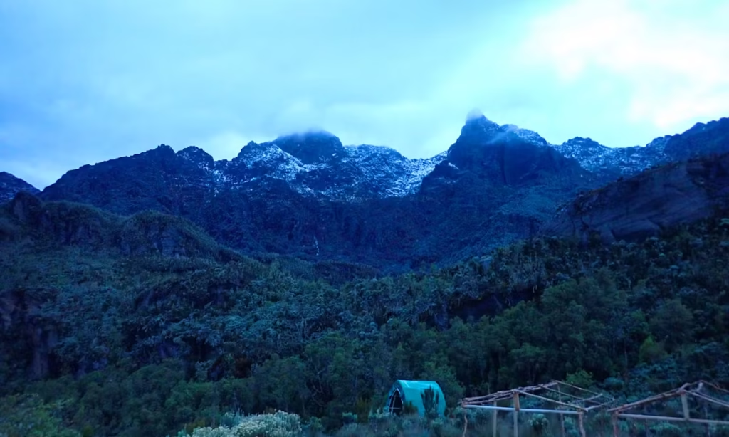
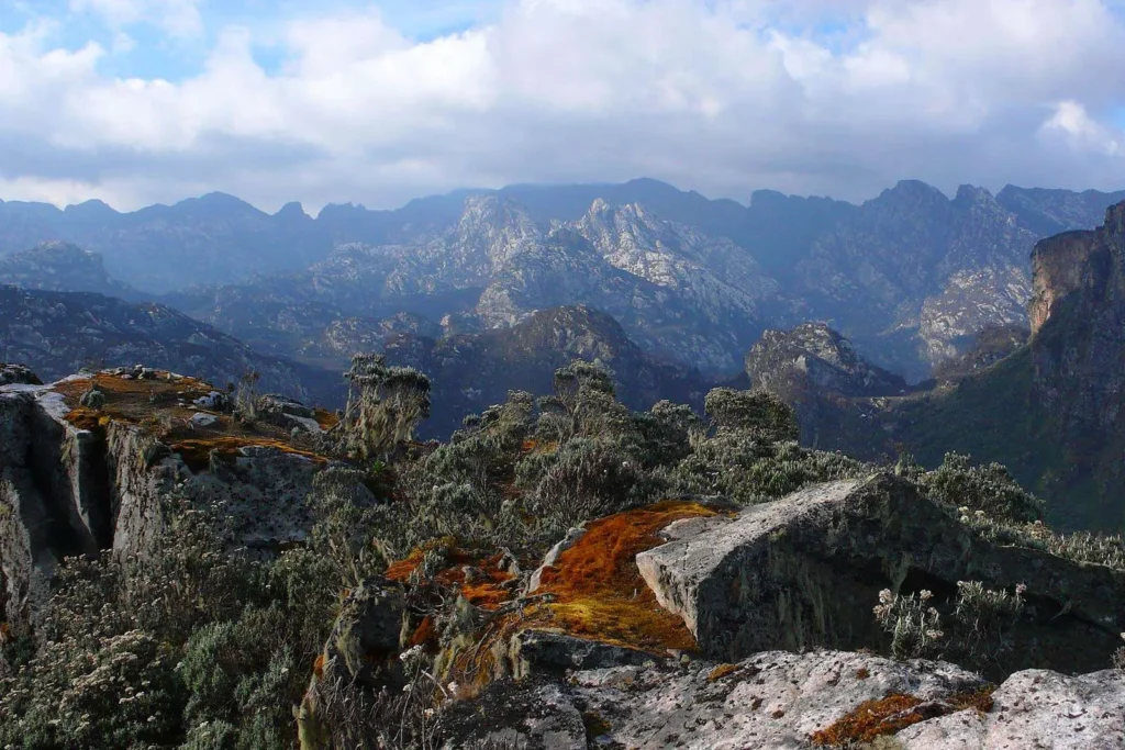
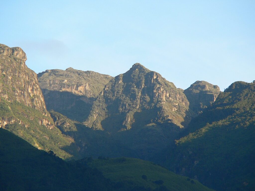
Understanding what you will see in the Rwenzori requires first understanding what kind of mountain range it is, because the Rwenzori is genuinely unlike anything else in Africa. These are not volcanic mountains. While Kilimanjaro, Mount Kenya, and the Virunga volcanoes were all built by magma, the Rwenzori are block mountains formed by tectonic uplift along the Albertine Rift. The range is composed of ancient Precambrian crystalline rocks, granites, gneisses, and amphibolites that were forced upward as the rift valley opened and deepened over millions of years. The result is a fundamentally different mountain character: deep, erosion-carved valleys; complex ridgeline topography; no craters or calderas; and, most distinctively, a persistent, almost geological cloud cover that keeps the high mountain perpetually damp and mysterious.
The range stretches approximately 120 kilometers in length and 50 kilometers in width, straddling the border between Uganda and the DRC. Six major massifs rise above 4,500 metres, and three retain permanent glaciers. The mountains receive more rainfall than almost any other range in Africa, producing the extraordinary botanical richness that makes their ecosystems so globally significant. UNESCO recognized this significance when it designated the Rwenzori Mountains National Park a World Heritage Site in 1994, making it one of very few mountain parks in Africa to receive this status.
The Albertine Rift, the broader biogeographical zone that encompasses the Rwenzori, has the highest density of endemic vertebrate species of any region in mainland Africa. The mountains themselves function as a biodiversity refuge, an island of high-altitude habitat surrounded by lowland savanna and forest, which has allowed species to evolve in isolation over geological time. The result is a wildlife and botanical inventory that is, in several important respects, unlike anything found elsewhere on Earth.
The Six Major Peaks: Africa’s Most Dramatic High-Altitude Summits
The most immediately dramatic attractions of the Rwenzori Mountains are its six major massifs, each rising above 4,500 metres and each with its summit complex, glacial features, and mountaineering history. Together they form the crown of the range, visible on rare clear days as a line of snow-capped ridges above the forest canopy from the plains far below, and they are the defining objective of every serious mountaineering expedition in the Rwenzori.
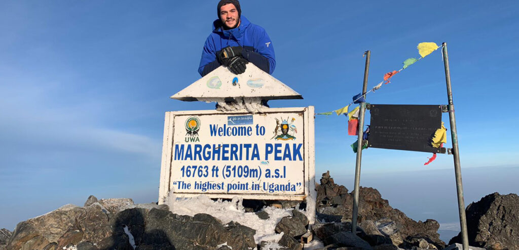
Margherita Peak and Mount Stanley (5,109 meters)
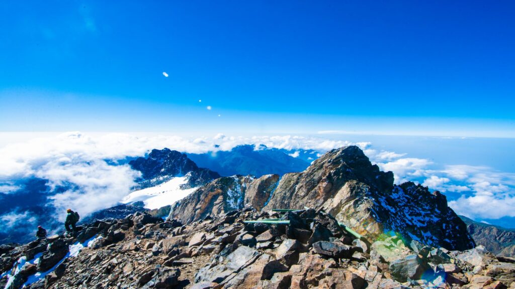
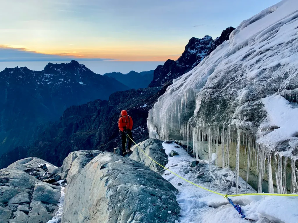
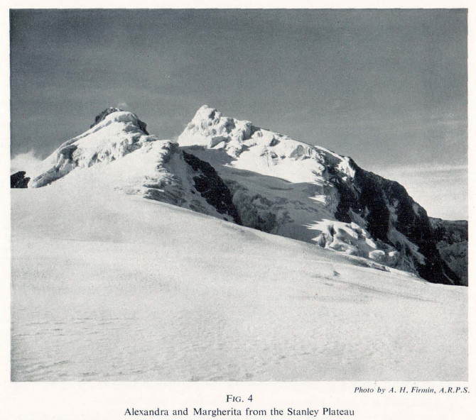
Mount Stanley is the highest peak in the Rwenzori range and Uganda’s highest mountain, with its summit, Margherita Peak, standing at 5,109 metres above sea level, making it the third highest point in Africa after Kilimanjaro (5,895m) and Mount Kenya (5,199m). The mountain carries a complex of three major summits: Margherita (5,109m), Alexandra (5,091m), and Albert (5,087m), all permanently glaciated and all first climbed by the Duke of Abruzzi’s Italian expedition in 1906. The view from Margherita Peak on a clear morning across the glaciated upper ridge of Stanley, down into the Congo to the west and toward Lake Edward in the east, is one of the defining visual experiences of African mountaineering. The summit approach via the Central Circuit Trail crosses the Stanley Glacier using a bridge and fixed ropes installed by the Uganda Wildlife Authority, making what was previously a hazardous glacier crossing into a manageable technical route for guided trekkers.
Mount Speke, 4,890 Metres
Mount Speke is the second highest Rwenzori massif and, for many experienced Rwenzori climbers, the most beautiful mountain in the range. Climbers approach its summit, Vittorio Emanuele Peak (4,890m), from the Bujuku Valley on the Central Circuit’s central section. The mountain’s eastern face presents a dramatic rock and ice wall above the Bujuku glacial valley, and the summit itself offers extraordinary panoramic views across the full range. The 9-day three-peaks expedition and several dedicated summit itineraries include Mount Speke for trekkers who want to experience its distinctive climbing character.
Mount Baker 4,843 Metres
Mount Baker stands between Mount Stanley and the Bujuku Valley, with its summit, Edward Peak (4,843 m), offering one of the most technically rewarding climbs on the Central Circuit. The mountain is traversed on the standard seven-day circuit between the Scott Elliot Pass and the Freshfield Pass, and its flanks form the western wall of the spectacular Kitandara valley. Baker’s summit route involves exposed ridge traversals with significant drops to both sides, and the views from Edward Peak across the Kitandara Lakes and down into the Congo basin below are among the most dramatic in the Rwenzori. The 5-day Edward Peak trek is a dedicated Baker itinerary for trekkers specifically targeting this summit.
Mount Emin, 4,798 Metres
Mount Emin is the fourth highest Rwenzori massif and one of the least visited, which gives it a particular appeal for those seeking genuine remoteness. Its summits, Umberto Peak (4,798 m) and Kraepelin Peak (4,700 m), are located in the northern sector of the range and are most commonly included in extended multi-peak expeditions. The approach to Mount Emin passes through landscapes less frequently encountered by mainstream trekkers, and the mountain’s relative isolation has preserved a quality of wilderness that even the Rwenzori’s other remote zones cannot quite match. The 7-day Mount Emin trek is the dedicated itinerary for this summit.
Mount Gessi, 4,715 Metres
Mount Gessi has two summits, Bottego Peak (4,715 m) and Iolanda Peak (4,650 m), and occupies the central-northern part of the range. Like Mount Emin, Gessi is usually found on extended grand expedition itineraries instead of standard circuits, and including it in a Rwenzori trek gives a very different mountain experience: different valley systems, different botanical communities at altitude, and a summit view that looks across the full northern arc of the range. The dedicated 7-day Mount Gessi trek provides a focused itinerary for reaching these summits.
Mount Luigi di Savoia, 4,627 Metres
Mount Luigi di Savoia, is the southernmost major massif and the last of the six to be climbed in a grand traverse of the range. Its two summits, Sella Peak (4,627 m) and Weismann Peak (4,620 m), are named for two members of the Duke of Abruzzi’s 1906 expedition, and the mountain’s southern position gives it views both across the main range to the north and down across the cultivated foothills toward Kasese in the southeast. Luigi di Savoia features in the 13-day six-peaks grand expedition and the 18-day all-peaks expedition.
The Equatorial Glaciers: Ice at the Heart of Africa
The glaciers of the Rwenzori are, in the truest sense, one of the world’s most extraordinary natural attractions, and they are disappearing. When you stand on the Stanley Glacier in the final approach to Margherita Peak, you are walking on equatorial ice that has existed continuously for thousands of years, the same ice that ancient geographers described as the source of the Nile and the same ice that the Duke of Abruzzi photographed in 1906 when it covered an area nearly seven times its current extent. You are also almost certainly looking at something that will not exist in its current form by the mid-century.
Scientific documentation of Rwenzori glacier retreat is unambiguous: from approximately 6.5 square kilometers of permanent ice in 1906, the range has lost more than 80% of its glacial coverage. Less than 1 square kilometer of glacier ice remains today, primarily on Mount Stanley’s upper massif, the Elena, Coronation, and Stanley glaciers, and on the flanks of Mount Speke. The Uganda Wildlife Authority’s installation of the glacier bridge and fixed rope system on the Margherita approach was itself a response to the changing glacier topography: as the ice retreats, new crevasse systems are exposed that require managed crossing infrastructure.
For every trekker who reaches the upper mountain on the Central Circuit, the glaciers are an unmissable attraction, whether seen from the distance of Elena Hut, crossed on summit day, or viewed from the summit of Margherita Peak, looking down on the fractured ice of the Stanley Plateau. Their visual drama is immense: blue-white ice against black volcanic rock, crevasse fields splitting the glacier surface in complex geometric patterns, and ice seracs gleaming in the pre-dawn headlamp light on summit morning. Their ecological significance is even greater: these glaciers are the primary source of the mountain streams that feed the Semliki River and ultimately contribute to the Nile system. Experiencing them now, before they vanish, is both a profound privilege and a form of witness.
The Giant Flora The Rwenzori’s Botanical Masterpiece
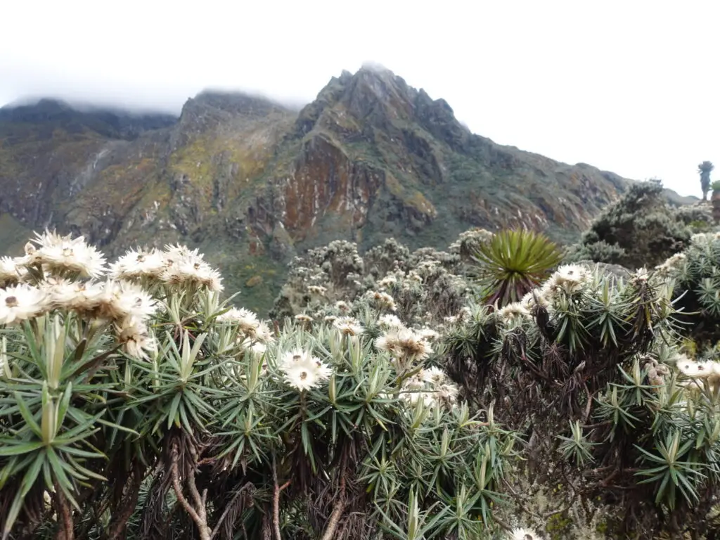
If the peaks and glaciers are the Rwenzori’s most famous attractions, the giant afro-alpine flora are its most astonishing. The vegetation zones of the Rwenzori Mountains rise dramatically from the tropical forest at the park’s lower boundary to the nival zone near the summits, and at the heart of this botanical progression, between roughly 3,500 and 4,500 metres elevation, lies a plant community so extraordinary that no written description has ever fully prepared a visitor for a first-hand encounter.
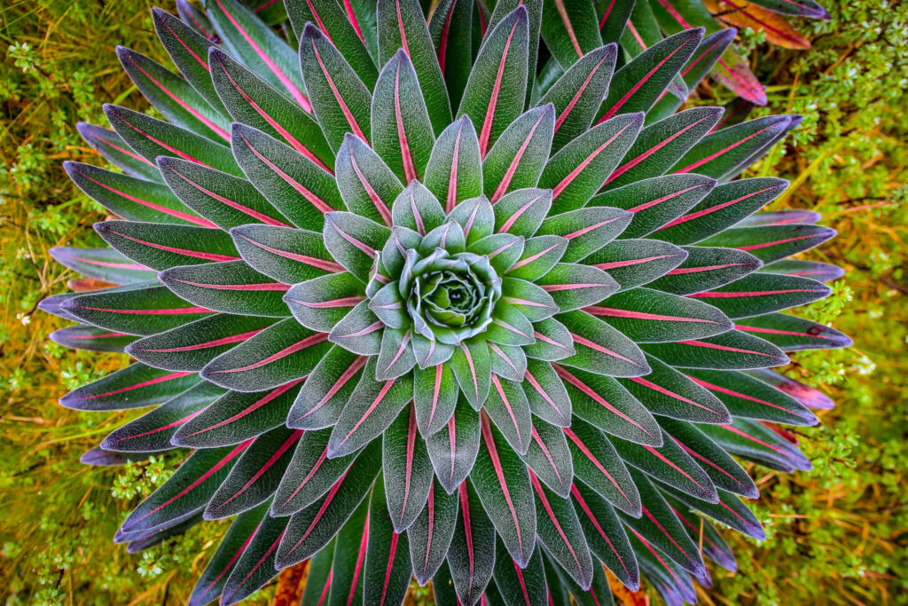
Giant Lobelias: Nature’s Most Improbable Plants
Lobelia wollastonii and Lobelia bequaertii are the flagship species of the Rwenzori’s afro-alpine zone. These are plants that elsewhere in the world grow as modest garden specimens of perhaps 30 centimeters; here, in the high mountain environment of equatorial Africa, they reach heights of three to four metres, with dense spike-crowned columns that close their rosettes at night to protect their growing cores from freezing temperatures. The adaptation is remarkable: each lobelia essentially builds an insulated microclimate within its leaf mass, maintaining an interior temperature several degrees above the ambient air temperature to protect the tender growing tissue from the nightly freezes that occur at these elevations year-round. Walking through a dense stand of giant lobelias in early morning mist, the columns emerging from fog in a forest of shapes that belong to no recognizable genre of normal experience, is one of the singular botanical encounters available anywhere on Earth.
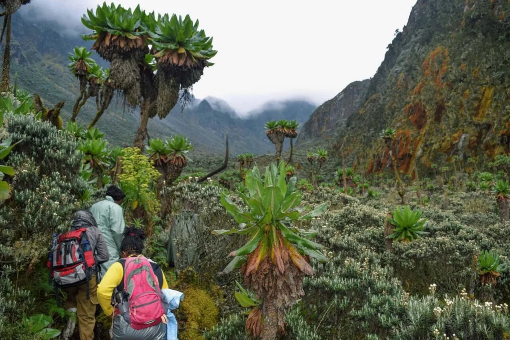
Giant Groundsels: Prehistoric Forests at Altitude
Senecio adnivalis, the giant groundsel, grows in the same afro-alpine zone as the lobelias, developing tall, single-trunk stems of four to seven metres topped by enormous rosettes of silvery-green leaves. Dense stands of these plants create what can only be described as prehistoric forests: the forms are ancient, the scale is wrong for any normal understanding of what a groundsel should look like, and the atmosphere, particularly in morning mist or drizzle, is otherworldly in a way that consistently impresses even the most experienced naturalists and mountaineers who visit. The Bujuku Valley and the slopes surrounding Lake Bujuku have some of the densest and most visually dramatic groundsel stands on the entire Central Circuit.
Tree Heathers: Ancient Architecture in Moss
At lower elevations in the heather zone, roughly between 2,500 and 3,500 metres, Erica arborea and related tree heather species create an equally remarkable forest of a different character. Here, the dominant feature is age and texture rather than sheer scale: the heather trunks are gnarled and contorted by decades of growth in wind-exposed, waterlogged soil, and every surface trunk, branch, and rock is covered in thick, dripping carpets of sphagnum and other mosses. The light in the heather zone is soft and filtered, the ambient sound is the constant drip of water and the calls of birds moving through the canopy, and the sense of profound biological age is overwhelming. These trees were growing long before any trekking route was cut through them.
Mosses, Everlastings, and Alpine Flowers
The Rwenzori’s botanical attractions extend beyond the iconic giant species. The moss carpets of the heather and lower alpine zones constitute some of the richest and most diverse bryophyte communities in Africa: dozens of sphagnum species, clubmosses, lichens, and liverworts coat every available surface, creating the thick, waterlogged substrate that imparts the Bigo Bogs their extraordinary character. Higher in the alpine zone, Helichrysum everlastings in multiple species create dense carpets of papery white and yellow flowers that persist long past the normal seasonal flowering of alpine plants at these latitudes. The entire botanical spectacle, from the forest wildflowers of the lower trail to the high-altitude everlastings near the glacier margins, represents one of the most comprehensive natural history attractions available on any mountain trek in Africa.
Wildlife of the Rwenzori Mountains: Endemics of the Albertine Rift
The wildlife of the Rwenzori Mountains is a subject that demands its own dedicated study. The Albertine Rift, where the Rwenzori Mountains are located, has the highest density of endemic vertebrate species of any region in mainland Africa. The mountains’ elevation range, cloud cover, and geographical isolation have made them a refuge for some of the continent’s rarest and most evolutionarily distinctive animals. For wildlife enthusiasts, the Rwenzori is not a secondary attraction to the mountains themselves: it is a primary destination in its own right.
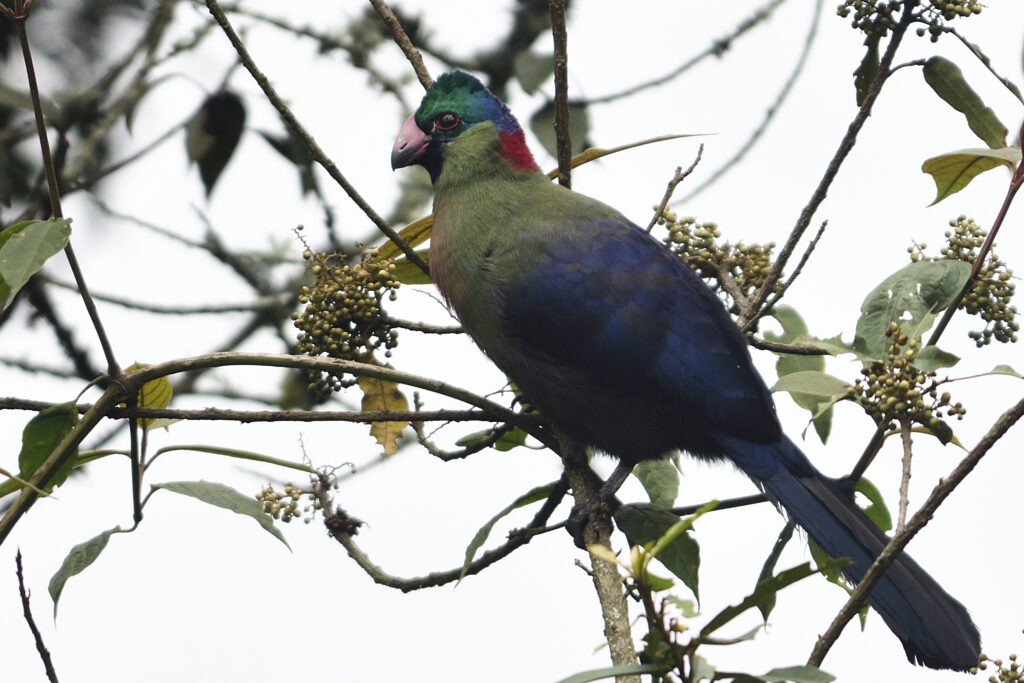
The Rwenzori Turaco: Icon of the Mountain Forest
The Rwenzori turaco (Ruwenzorornis johnstoni) is the most celebrated bird in the park and one of the most striking birds in Africa. A medium-sized turaco with deep crimson, iridescent purple, and vivid green plumage has red wing primaries that come from a unique copper-based pigment called “turacin,” found in no other bird family. The Rwenzori turaco announces itself long before it is seen, with a loud, resonant call that echoes through the montane forest from first light. It is most reliably encountered in the forest zone between the park gate and Nyabitaba Hut, and its combination of beauty and distinctive call makes it one of the most memorable wildlife encounters on the lower trail.
L’Hoest’s Monkey and the Black-and-White Colobus
On the lower Central Circuit and Diamond Trail sections of the park, visitors regularly encounter two primate species. L’Hoest’s monkey (Allochrocebus lhoestii) is a ground-dwelling species with a distinctive white bib and dark brown coat. It is often seen near Nyabitaba Hut and in the dense forest of the Mubuku valley, usually in troops of ten to twenty individuals that move slowly and directly through the mid-canopy and understory. The black-and-white colobus (Colobus guereza), with its dramatic long black-and-white mantle and prehensile-tail dexterity, is visible in the large trees near the forest edge and at higher elevations than most other primates in the park. Both species are diurnal and relatively habituated to trekkers on the established trails, making genuine wildlife observation rather than mere fleeting glimpses a realistic prospect on most expeditions.
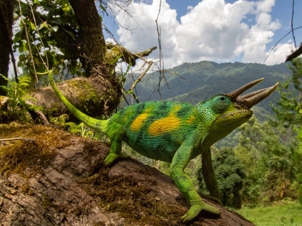
The Three-Horned Chameleon
Trioceros johnstoni, the Rwenzori three-horned chameleon, is one of the most memorable reptile encounters available anywhere in the Rwenzori forests. Males carry three prominent horns on their snouts; their colors shift through a remarkable range of greens, browns, and yellows in response to temperature, light, and social signals; and their famous independent eye movement gives them a quality of watchfulness that feels almost cognitive. They are found throughout the montane forest zone and are most commonly encountered in the trail-side vegetation near the lower huts, often on branches at eye height and apparently unconcerned by the proximity of passing trekkers.
Forest Elephants and the Rwenzori Red Duiker
Forest elephants use corridors through the lower sectors of the park, and evidence of their passage broken branches, wallowing pools, and the enormous root-torn channels they cut through dense understory is commonly visible near the valley floors below Nyabitaba Hut. Actual sightings require patience and fortune: forest elephants are significantly more secretive than their savanna relatives, and their use of the Rwenzori corridors is primarily nocturnal. The Rwenzori red duiker (Cephalophus rubidus), a small antelope endemic to the range, is occasionally seen near the forest huts, particularly at dawn and dusk, and the olive duiker is also present at mid-altitude forest zones.
BirdLife: A Listing Paradise for Albertine Rift Endemics
Beyond the turaco, the Rwenzori supports an exceptional diversity of bird life. The park’s checklist includes more than 200 species, with a significant proportion of these classified as Albertine Rift endemic species found only within this biogeographical zone. The Handsome Francolin (Pternistis nobilis), Rwenzori Batis (Batis diops), and Ruwenzori Nightjar (Caprimulgus ruwenzorii) are among the most sought-after by serious birders. Several sunbird species, including the striking Regal Sunbird (Cinnyris regius) and the Purple-breasted Sunbird, are common in the heather and lower alpine zones. The high-altitude nival zone above 4,000 metres hosts the Alpine Chat (Oenanthe sordida) and occasional sightings of high-flying raptors, including Augur Buzzards riding the thermals above the upper valleys. For the serious birder, a dedicated 2-day birdwatching trek to Sine Camp provides an excellent introduction to the Rwenzori’s avian richness without committing to the full circuit.
Chimpanzees on the Diamond Trail
The Diamond Trail, a lower-altitude route within Rwenzori Mountains National Park, provides the best opportunity in the park for chimpanzee observation. The forest along this trail supports a resident chimpanzee community, and guided chimpanzee trekking on the Diamond Trail can be combined with a Central Circuit expedition or undertaken as a standalone day activity from the park’s lower zone. Combining chimpanzee habituation with high-altitude mountaineering in a single expedition remains one of the most distinctive itinerary combinations the Rwenzori offers.
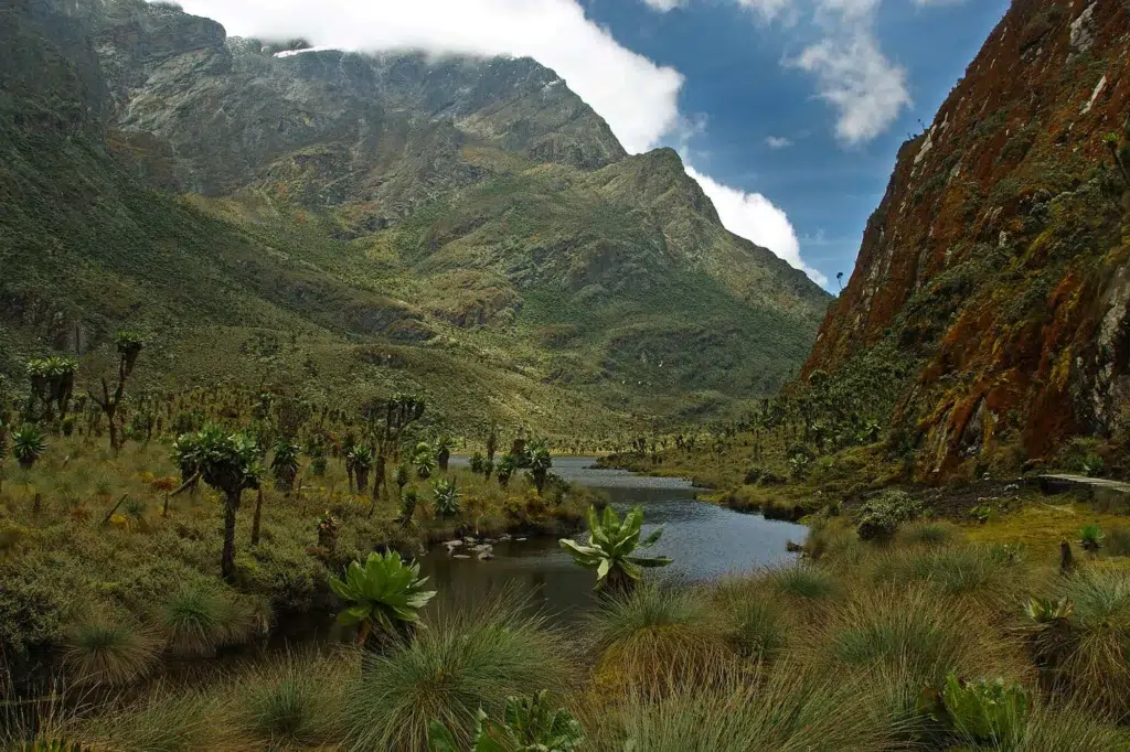
The Alpine Lakes: Mirror Waters at the Roof of Africa
The Rwenzori Mountains contain some of the most beautiful and least-visited high-altitude lakes in Africa. Tucked into glacial cirques, spread across elevated valley floors, and fed by permanent glacial meltwater and high-rainfall catchments, these lakes are among the most atmospheric attractions the mountains offer, and several are accessible even to trekkers who do not intend to summit.
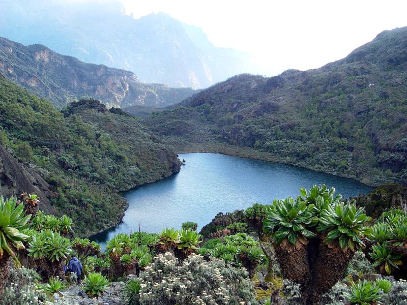
Lake Bujuku: The Heart of the Central Circuit
Lake Bujuku (approximately 3,962 m) sits at the convergence of the three highest valleys in the Central Circuit, with the flanks of Mount Stanley, Mount Speke, and Mount Baker rising above it in a spectacular natural amphitheater. The lake is dark-watered, still except in high winds, and surrounded on its western and northern shores by dense stands of giant groundsels and lobelias. On clear mornings, before the clouds build, the reflections of the encircling peaks in the lake’s surface create one of the most photographically remarkable compositions in the Rwenzori Mountains. Bujuku Hut sits a short distance from the lakeshore, and the lake itself, visible from the hut veranda at dawn, is one of those landscapes that rewards simply sitting still and watching.
The Kitandara Lakes: Twin Jewels of the Southern Circuit
The two Kitandara Lakes occupy a spectacular glacial valley at approximately 4,023 metres on the southern side of the Central Circuit between the Scott Elliot and Freshfield Passes. Fed by glacial meltwater from Mount Baker’s flanks and surrounded by a broad alpine meadow studded with everlastings and mosses, the Kitandara Lakes have a quality of light and stillness that many trekkers consider the single most beautiful landscape encounter on the entire circuit. The upper lake in particular, viewed from the trail descending from the Scott Elliot Pass, with the ice-streaked ridgeline of Mount Baker visible above, forms one of those compositions that fix themselves permanently in the memory.
Lake Mahoma: The Accessible Wonder
Lake Mahoma occupies a lower-altitude position within the park’s forest zone, making it one of the most accessible of the Rwenzori’s significant lakes and an excellent destination for trekkers who want to experience the mountain’s character without the physical demands of the high circuit. The 2-day Lake Mahoma hike and the 3-day Mahoma Loop are both popular itineraries that combine the lake with the forest trail experience. The lake itself sits in a forested basin, its surface reflecting the surrounding tree canopy, and the atmosphere around it, particularly at dawn and dusk, when bird activity is most intense, is quietly extraordinary.
The Bukurungu Trail Lakes
The Bukurungu Trail, the third major Rwenzori trekking route, is particularly noted for the four high-altitude lakes it passes, a concentration of alpine water bodies that distinguishes it from both the Central Circuit and the Kilembe Trail. For trekkers who have already completed the Central Circuit and are returning for a different Rwenzori experience, the Bukurungu Trail’s lake sequence offers a compelling alternative perspective on the mountain’s landscapes.
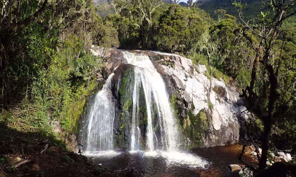
The Rwenzori’s extraordinary rainfall and complex drainage network produces a mountain range alive with the sound and spectacle of falling water. From cascading forest streams in the lower zones to powerful mountain torrents cutting through the heather highlands, waterfalls and rivers are a constant and exhilarating presence throughout any Rwenzori trek.
The Mubuku River, the primary drainage of the Central Circuit’s main valley, runs strong and fast throughout the year, and its crossings, particularly the Kurt Schafer Bridge crossing above the gorge waterfall on the second day of the circuit, are dramatic moments that mark genuine transitions in the trek’s altitude and character. The waterfall below the bridge is one of the most photographed features on the lower Central Circuit: a powerful cascade dropping into a deep rocky gorge, surrounded by overhanging moss and fern, with the roar of the water audible well before the crossing comes into view.
The Kilembe Trail, the alternative major route into the Rwenzori from the south, is particularly rich in waterfall attractions, and the 4-day Rwenzori Waterfalls Hike is a dedicated itinerary designed specifically around the most spectacular waterfall sequences along the Kilembe approach. Samalira Falls, encountered on the 3-day Sine Camp and Samalira Falls hike, is a broad, powerful waterfall in the lower forest zone, accessible to trekkers who are not planning to do the full high circuit.
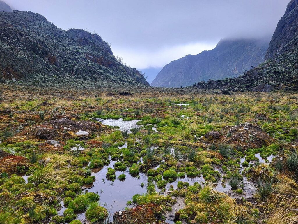
The Bigo Bogs: An Ancient Peatland Ecosystem
The Bigo Bogs occupy the broad valley floors of the Mubuku and Bujuku valleys at elevations of roughly 3,000 to 3,800 metres along the Central Circuit. They are, in the strictest ecological sense, blanket mires: extensive peatlands formed by tens of thousands of years of slow decomposition in waterlogged, cold, high-altitude conditions. The peat deposits in some sections of the Bigo Bogs are several metres deep, serving as organic archives of the mountain’s climate history that span thousands of years.
Before the installation of elevated wooden boardwalks by Rwenzori Mountaineering Services, the bog crossings were the most genuinely hazardous section of any Rwenzori trek: trekkers could and regularly did sink to the waist in cold black peat, and the physical effort of extracting oneself from deep bog mud was both exhausting and potentially dangerous. The boardwalks have transformed the crossing from ordeal to attraction: traversing them, with the bog surface stretching away on both sides dotted with giant lobelias emerging from the mist, the air cool and completely still, and the silence broken only by bird calls and the creak of the wooden boards underfoot, is one of the most atmospheric experiences on the entire Central Circuit.
From a purely ecological standpoint, the Bigo Bogs are among the most significant high-altitude peatlands in East Africa. The plant communities that live there, including specialist bog mosses, sedges, and the interface between aquatic and terrestrial vegetation at altitude, create an ecosystem that is both scientifically important and globally rare. For naturalists and ecotourists, the bogs attract visitors in their own right rather than merely acting as a terrain challenge to cross.
The Trekking Routes Themselves: Three Journeys Into Different Worlds
One of the less-discussed but genuinely significant attractions of the Rwenzori Mountains is the quality and variety of the trekking routes themselves. Unlike some mountain ranges where all approaches converge on a single corridor of trail, the Rwenzori offers three substantially different primary routes, each with a distinct character, ecology, difficulty profile, and experience, plus a growing network of shorter approach trails that open up the mountain’s lower zones to trekkers with less time or experience.
The Central Circuit Trail is the original and most comprehensive route, following a loop through the mountain’s central massif with access to all three highest peaks and the full sequence of vegetation zones from forest to glacier. It is the route that most accurately represents the full Rwenzori experience.
The Kilembe Trail approaches from the southeast, from the former copper-mining town of Kilembe near Kasese. Rwenzori Trekking Services (RTS) operates the trail, which is generally considered more technically demanding in its lower sections than the Central Circuit and has a distinctly different ecological character, especially in the forest and bamboo zones of the lower approach.
The Bukurungu Trail is the most wilderness-oriented of the three major routes, the one for trekkers who want to experience the Rwenzori as early explorers did, before huts and boardwalks transformed the mountain into a managed trekking destination. Camping-based and passing four high-altitude lakes, the Bukurungu Trail crosses terrain that is less frequently walked than either of the other major routes, offering an experience of rawness and remoteness that is the defining attraction for a specific type of adventurous traveler.
Historical and Exploration Attractions: Walking in the Footsteps of Legends
The Rwenzori Mountains’ historyis one of the most compelling attractions of any visit to the range. These mountains were described by the ancient geographer Ptolemy in the second century AD as the legendary ‘Mountains of the Moon,’ the mythical source of the Nile whose snow-capped peaks fed Africa’s greatest river. For nearly eighteen centuries, the range remained one of geography’s most enduring mysteries. When Henry Morton Stanley glimpsed the snow-capped summits through breaking cloud in 1888, he confirmed a myth that had persisted since antiquity.
The Duke of Abruzzi’s 1906 expedition, which achieved the first ascents of all six major massifs in a single season, is the defining historical event of Rwenzori mountaineering. The expedition’s systematic approach, its photographic documentation of the glaciers and landscapes, and the naming conventions it established (which have endured to the present day) make it one of the most significant episodes in the history of African exploration. Walking the same ridgelines the Duke’s climbers ascended in 1906, sleeping in huts positioned at the same elevations their camps once occupied, and standing on the same summits their first ascents reached, this historical connection is a genuine dimension of the Rwenzori experience that distinguishes it from any other mountain in Africa.
The Bakonzo People and Cultural Attractions
The Bakonzo (also known as the Konzo or Bakonjo) are the indigenous people of the Rwenzori Mountains, the communities that have lived on and around these peaks for centuries, farming the fertile lower slopes, hunting in the forest margins, and maintaining a cultural relationship with the mountains that is ancient and deeply rooted. Any visit to the Rwenzori that does not engage with Bakonzo culture is missing a significant dimension of what makes this mountain range remarkable.
The Bakonzo guides and porters who accompany every trekking expedition on the Central Circuit and other routes are not merely service providers: they are cultural ambassadors, mountain professionals of extraordinary physical capability, and the living continuation of a relationship between their communities and this landscape that predates any trekking infrastructure by generations. Their knowledge of the mountain’s microclimates, wildlife behavior, and ecological systems is encyclopedic and accumulated across family lineages that have spent centuries on this terrain. Spending seven days on the mountain with Bakonzo guides, sharing mealtimes at the huts, listening to their observations about weather and wildlife, and understanding their reading of the mountain’s moods is an irreplaceable human dimension of the Rwenzori experience.
The Bakonzo cultural tradition includes a rich oral history relating to the mountains: creation stories in which the peaks were formed by divine action, legends of the first peoples to climb toward the snowline, and a complex system of ecological knowledge that includes the identification and uses of hundreds of plant species in the mountain forests. The community villages at the base of the mountains along the approach roads to Nyakalengija and near Kilembe offer pre-trek cultural encounters that contextualize the mountain experience within the human history of the place.
UNESCO World Heritage Status and Scientific Significance
The Rwenzori Mountains National Park was inscribed on the UNESCO World Heritage List in 1994, recognized for its outstanding universal value under both natural heritage criteria: its exceptional biodiversity and the remarkable ecological processes represented by its vegetation zonation, endemic species, and glacial systems. This designation places the Rwenzori among a small group of Africa’s most globally significant natural sites, and it is a designation that genuinely reflects the park’s scientific importance rather than being purely symbolic.
The park’s outstanding natural value has attracted decades of scientific research, including ecological surveys of the vegetation zones, glaciological monitoring of the retreating ice, ornithological studies documenting Albertine Rift endemics, and entomological surveys that have consistently identified new species. For scientifically inclined visitors, the Rwenzori represents one of the most genuinely research-rich natural environments accessible by foot on the African continent. The detailed account of why the Rwenzori’s glaciers are disappearing represents the most urgent and globally relevant scientific story the mountains currently tell.
Photography in the Rwenzori: A Visual World of Extraordinary Richness
For photographers, the Rwenzori Mountains represent one of the most productive and distinctive environments in Africa. The combination of rare and endemic wildlife, extraordinary botanical subjects, dramatic landscapes at multiple elevations, the interplay of equatorial light with high-altitude mist and cloud, and the constant textural richness of the moss-covered forests and bog environments creates a photographic opportunity that is both highly varied and deeply unusual.
The forest zone offers close-encounter wildlife photography with L’Hoest’s monkeys, three-horned chameleons, and the Rwenzori turaco, all of which are reasonably habituated to trekkers on established trails and can be approached more closely than many other African wildlife subjects. The afro-alpine zone’s botanical subjects, including giant lobelias in morning mist, groundsel forests backlit by afternoon sun, and moss carpets with fine textural detail, reward both macro and wide-angle lenses. Summit day offers the once-in-a-career image of equatorial glacier ice in the pre-dawn darkness, the first light touching the Alexandra Peak snowfields above, and the sweeping panoramic view from Margherita Peak itself. And the lake reflections, Bujuku and Kitandara in particular, deliver landscape compositions of a caliber that place them among the most dramatic mountain photography locations in Africa.
Gateway Attractions: What to See Near the Rwenzori Mountains
The Rwenzori Mountains sit in one of Uganda’s most richly endowed regions for wider safari and natural history interests. Kasese, the primary gateway town, lies between the mountains and Queen Elizabeth National Park, one of Uganda’s most productive savanna reserves. The combination of a Rwenzori trekking expedition with a Queen Elizabeth safari provides a strikingly complete Uganda wildlife experience: equatorial glaciers and endemic mountain species in the Rwenzori, then the dramatic lake-and-savanna landscapes of the rift valley floor with elephants, hippos, lions, and tree-climbing leopards just an hour’s drive away. Several Rwenzori-and-gorilla combination itineraries extend the experience further to include gorilla trekking in Bwindi Impenetrable Forest.
Fort Portal, an hour’s drive north of Kasese, is a pleasant highland city set in rolling tea country with access to the Tooro Kingdom Palace, the Amabere Caves, and several crater lake walking trails. For international trekkers arriving in the region a day or two before their Rwenzori expedition begins, Fort Portal provides a comfortable and culturally enriching base with excellent accommodation, restaurants, and the opportunity to acclimatize gently to the altitude of the western Uganda highlands before ascending the mountain.
Frequently Asked Questions about the Attractions in the Rwenzori Mountains
What are the main attractions of the Rwenzori Mountains?
The main attractions of the Rwenzori Mountains fall into several distinct categories. The six major peaks, led by Mount Stanley’s Margherita Peak at 5,109 metres, Africa’s third highest summit, are the defining mountaineering attractions and the primary objective for most expedition trekkers. Africa’s last equatorial glaciers are a globally rare natural wonder, surviving on Mount Stanley and Mount Speke despite losing more than 80% of their coverage in the past century. This extraordinary afro-alpine flora, which includes giant lobelias and giant groundsels that grow to several metres in height, grows nowhere else on Earth. Endemic wildlife, such as the Rwenzori turaco, L’Hoest’s monkey, three-horned chameleons, and over 200 bird species, many of which are Albertine Rift endemics, contribute to the area’s rich biological diversity. The alpine lakes Bujuku, Kitandara, and Mahoma, chief among them, are spectacularly beautiful. And the historical and cultural dimensions, the legacy of the Duke of Abruzzi’s 1906 first ascent, and the living culture of the indigenous Bakonzo communities provide a human context that enriches every visit.
What makes the Rwenzori Mountains different from other African mountains?
The Rwenzori Mountains are fundamentally different from other African mountains in several ways. Unlike Kilimanjaro and Mount Kenya, which are volcanic peaks, the Rwenzori are block mountains formed by tectonic uplift of ancient crystalline rocks pushed upward along the Albertine Rift. This geological origin imparts them a structurally different character: deeply eroded valleys, complex ridgeline topography, and no volcanic craters. Their botanical attractions, particularly the giant lobelias and giant groundsels of the afro-alpine zone, exist in this extraordinary form only in a small number of equatorial African ranges, and the Rwenzori’s examples are among the finest. The mountains are also significantly wetter than other major African ranges, which explains both their botanical richness and their reputation for challenging trekking conditions. Their UNESCO World Heritage Status reflects a combination of scientific values, biodiversity, ecological processes, and glacial systems that is not matched by any other single mountain environment in East Africa.
Can I see glaciers in the Rwenzori Mountains?
Yes, the Rwenzori Mountains contain Africa’s last remaining equatorial glaciers, primarily on the upper massif of Mount Stanley (the Elena, Coronation, and Stanley Glaciers) and on the flanks of Mount Speke. However, these glaciers have retreated dramatically: from approximately 6.5 square kilometers of permanent ice in 1906 to less than 1 square kilometer today. Trekkers on the 6-day, 7-day, and longer Central Circuit itineraries that include the Margherita Peak summit approach will cross glacier ice on summit day and observe it at close range from Elena Hut. The glaciers are visible from a distance from Bujuku Hut and from the Scott Elliot Pass. Current scientific projections suggest the remaining ice may disappear before 2050, which means you will have a genuinely limited window to experience glacier trekking in the Rwenzori.
What wildlife can I expect to see in the Rwenzori Mountains?
Wildlife encounters in the Rwenzori depend primarily on the elevation zones you pass through. In the lower montane forest zone, L’Hoest’s monkeys and black-and-white colobus are regularly observed; three-horned chameleons are commonly encountered in the trail-side vegetation; and the Rwenzori turaco, one of Africa’s most striking birds, is reliably heard and frequently seen. Forest elephants use corridors through the lower park, and signs of their passage are visible even when the animals themselves are not. In the mid-altitude heather and afro-alpine zones, bird activity remains high with multiple sunbird species, the Handsome Francolin, the Rwenzori Batis, and many Albertine Rift endemics. The Rwenzori red duiker is present throughout the forest and lower alpine zones. Chimpanzees can be observed on the Diamond Trail section of the park.
Are the giant lobelias and groundsels real, and where do I see them?
Yes, they are entirely real, though the photographs of them do look like they belong to a science fiction film. Giant lobelias (Lobelia wollastonii and Lobelia bequaertii) grow to three to four metres in height in the afro-alpine zone, at elevations between approximately 3,500 and 4,500 metres, with dense spike-crowned forms that close their rosettes at night to protect against frost. Giant groundsels (Senecio adnivalis) grow even taller, with single-trunk stems topped by large rosettes of silvery-green leaves, forming forests that look like no other plant community on Earth. Both species are most dramatically encountered in the Bujuku Valley around Lake Bujuku and on the approaches from John Matte Hut, continuing through the afro-alpine zone up to the glacier margins. Every trekker on the Central Circuit who reaches Bujuku Hut will spend at least a full day walking through these extraordinary plant communities.
What are the best lakes to see in the Rwenzori Mountains?
The most spectacular lake in the Rwenzori is Lake Bujuku, located at approximately 3,962 metres in the heart of the Central Circuit’s high mountain zone, encircled by the flanks of Mount Stanley, Mount Speke, and Mount Baker. Its dark water, the surrounding giant groundsel vegetation, and the mountain panorama that reflects on its surface during calm mornings make it one of the most iconic landscape attractions in the entire range. The Kitandara Lakes, two connected alpine lakes in the glacial valley on the southern side of the circuit, are equally beautiful and arguably even more photogenic in clear conditions. Lake Mahoma, at a lower elevation and accessible on short trekking itineraries, is the most easily reached significant lake and an excellent destination for day trekkers or those on shorter schedules.
Is the Rwenzori suitable for non-trekkers or casual visitors?
The Rwenzori Mountains are primarily a trekking and mountaineering destination, and the most dramatic attractions, the peaks, glaciers, giant flora, and high alpine lakes, require multi-day treks to access. However, several shorter options provide genuine access to the mountain’s lower-elevation attractions without the full physical demands of the high circuit. The 1-day trek to Nyabitaba Camp, the 2-day Lake Mahoma hike, and the 3-day Mahoma Loop all offer meaningful encounters with the Rwenzori’s montane forest, birdlife, and lower botanical richness for visitors who are not planning a full mountaineering expedition. The Kasese gateway area also provides views of the mountain range from below and access to the cultural context of the Bakonzo communities living at the mountain’s base.
What is the best time of year to see the Rwenzori Mountains in their best condition?
The Rwenzori’s most photogenic and most dramatically visible conditions occur during the two drier windows of the year: January to February and June to August. During these periods, cloud cover is somewhat reduced, summit views are more frequently clear, and the mountain’s dramatic ridgelines and snow-capped peaks are most visible from the lower approaches. The giant flora is, however, magnificent year-round: the giant lobelias and groundsels are not seasonal plants but permanent features of the afro-alpine zone regardless of the month. Bird activity is also reliably high throughout the year, and the Rwenzori turaco and other forest species are as easily encountered in the wetter months as in the drier ones. The key practical difference is trail conditions: the drier months offer less mud, better bog boardwalk conditions, and more comfortable trekking overall.
See the Rwenzori for Yourself: Begin Planning Your Expedition
You cannot adequately appreciate the attractions of the Rwenzori Mountains from a distance. They require presence: the smell of the moss forests after rain, the sound of the Mubuku River in the gorge below the Kurt Schafer Bridge, the physical sensation of altitude in the chest at 4,500 metres, and the visual impact of Lake Bujuku at dawn, still as a mirror, with three glacier-capped peaks rising above it in the first light. These are experiences that a photograph approximates and a guidebook describes, but that only walking the mountain itself delivers.
Rwenzori Trekking Safaris specializes exclusively in guided expeditions in the Rwenzori Mountains. Our Bakonzo guides carry decades of accumulated route knowledge; our logistics are refined and reliable; and our commitment to the communities at the mountain’s base through the direct donation of a percentage of every safari’s proceeds to Bakonzo orphan support, schools, and homes reflects a philosophy of responsible tourism that we believe makes the experience more meaningful for every trekker we guide.
Reach out to our team through the contact page, explore the full range of trekking itineraries from day hikes to 13-day grand expeditions, and let a dedicated specialist help you design the Rwenzori experience that matches your ambitions, your timeline, and your physical capabilities. The glaciers are retreating, the mountain is changing, and the window to see the Rwenzori in its full, ice-capped glory is genuinely finite. The time to go is now.
ANY QUESTIONS?
If you need any clarification about a Rwenzori trek, contact one of our trekking experts to start planning your journey today.
A 10% percentage of your safari proceeds goes to supporting the local Bakonjo Communities (orphans, schools & homes)
Hi there, welcome. Need help planning a trek, safari, or adventure? Chat directly with a real expert and mountain guide for honest advice, clear answers, and practical recommendations. No guesswork, no pressure.