Trek to both Edward Peak on Mt. Baker (4,843m) & Weismann’s Peak (4,620m) via the Kilembe Trail in 7 days. Uganda’s only dual-summit Kilembe expedition. Book now.
7-Day Mt Baker & Weismann Peak Trek | Kilembe Trail
7-Day Rwenzori Trek to Mount Baker & Weismann Peak via Kilembe Trail
Two Summits. One Traverse. The Kilembe Trail’s Premier Dual-Peak Expedition
This is the only guided Rwenzori itinerary that takes you to both Edward Peak on Mount Baker (4,843 m) and Weismann’s Peak (4,620m) in a single expedition. Seven days along the raw, remote Kilembe Trail through cathedral forest, surreal Afro-alpine bogs, and over the great Bamwanjara Pass, culminating in two separate summit days and a descent through the dramatic Nyamwamba Valley gorge. If you want the full Kilembe experience without Margherita’s glacier demands, this is it.
Experience the best of Uganda’s Rwenzori Mountains on this 7-day trek to Mount Baker (4,842 m) and Weismann Peak (4,620 m) via the scenic Kilembe Trail. Explore Afro-montane forests, glacier views, and rich biodiversity with Rwenzori Trekking Safaris.
Join Rwenzori Trekking Safaris for a 7-day mountaineering trek to the Rwenzori Mountains, where you’ll see two iconic peaks: Mount Baker (Edward Peak, 4,842 m) and Weismann Peak (4,620 m). For the fit hiker who wants to see the Alps away from Margherita’s throng, this is the perfect trek. You may get up close and personal with the mountain’s unique animals and enjoy the greatest views of Mount Stanley’s glaciated peaks from there.
Mount Baker, also known as Kiyanja, is a mountain in Uganda’s Rwenzori Mountains National Park, located 2.8 kilometers from the DRC border. The Rwenzori Tour is a 7-day climb with an elevation of 4,844 meters.
Weismann Peak is a lesser-known yet stunning mountain in the Rwenzori Mountains. It is between Mount Luigi di Savoia and Mount Baker. It is on the Central Circuit, the main hiking circle, and most visitors reach it by choosing the Kilembe Trail, a calmer and more scenic southern path operated by Rwenzori Trekking Services. Weismann Peak is not technical, so you won’t need crampons or ropes most of the year. The peak differs from Mount Stanley and Mount Baker. However, due to its elevation and rugged terrain, climbing at high altitudes demands stamina and competence.
7-Day Mount Baker & Weismann Peak Trek: At-a-Glance
| Duration | 7 days / 6 nights |
| Total Distance | ~67 km point-to-point (Kilembe Trailhead → Nyamwamba Valley exit) |
| Summit 1 | Edward Peak, Mount Baker 4,843 m (Day 5) |
| Summit 2 | Weismann’s Peak, Mount Luigi di Savoia 4,620 m (Day 6) |
| Highest Camp | Hunwick’s Camp: 3,974 m (Days 4 & 5 overnight) |
| Total Ascent | ~3,500 m cumulative across both summit days |
| Difficulty | Hard-experienced multi-day trekkers; prior altitude exposure recommended |
| Technical Gear | Safety ropes on steep Baker sections (provided); no crampons or glacier travel |
| Trail Used | Kilembe Trail (Rwenzori Mountains National Park, southern approach) |
| Start Point | Rwenzori Backpackers Hostel (Trekkers Hostel), Kilembe (~35km from Kasese) |
| End Point | Nyamwamba Valley trailhead exit point-to-point traverse |
| Best Months | January–February & June–August (drier, most stable conditions) |
| Group Size | 2–10 trekkers (private departures available on any date) |
| Accommodation | Mountain huts: Sine, Mutinda, Bugata, Hunwick’s (×2 nights), Kiharo |
| Meals | All meals from Day 1 lunch to Day 7 lunch |
| Price Indicator | From 1,600 USD |
| Park Authority | Uganda Wildlife Authority (UWA) |
Why Choose the 7-Day Mount Baker & Weismann Peak Trek?
The defining characteristic of this 7-day Rwenzori expedition is its dual-summit structure, and that distinction matters enormously. The 6-day Weismann’s Peak expedition takes you to one summit. The 8-day Kilembe Trail to Margherita Peak requires glacier travel. This 7-day route occupies the precise middle ground: two named Rwenzori summits, both accessible as high-altitude trekking peaks without crampons or ropes beyond safety lines on Baker’s steeper rock sections, all within a single point-to-point traverse of the Kilembe Trail. No other 7-day Rwenzori itinerary delivers this combination.
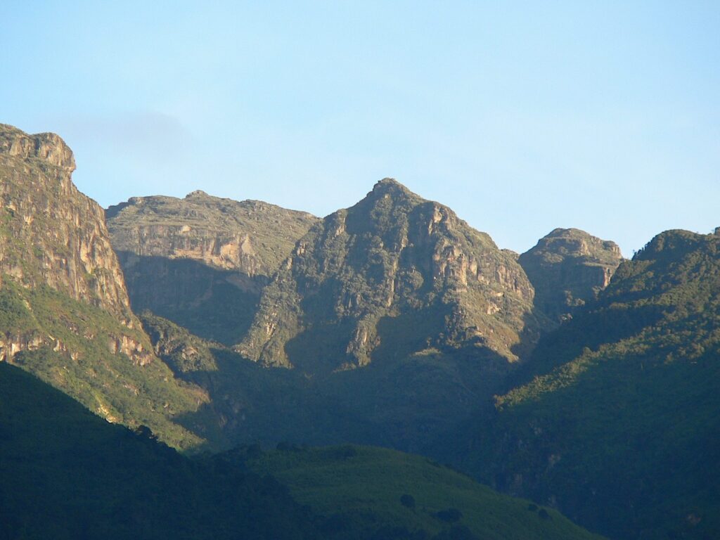
Mount Baker (4,843m) locally known as Kiyanja, is the Rwenzori’s third-highest massif and one of its least-climbed major peaks. Its highest point, Edward Peak, stands 2.8 kilometers from the DRC border, with views across Mount Stanley (5,109m) to the northwest and the full sweep of the inner Rwenzori to the north and east. The summit approach from Hunwick’s Camp is steep and rocky. In the wet season, it involves genuinely icy rock faces, and your guide will use safety ropes on the most exposed sections, regardless of the season. This is a mountain that tests competence as well as fitness. It is not dangerous with experienced guides, but it is not a casual walk.
Weismann’s Peak (4,620m) on Mount Luigi di Savoia is summited the following day, approached from Hunwick’s Camp via Oliver’s Pass, a completely different line from the Baker summit, through a different landscape, with different views. The combination of standing on Baker and looking across at Weismann’s ridge on Day 5, followed by standing on Weismann’s and looking back at Baker’s summit on Day 6, is something that cannot be replicated on any other Rwenzori itinerary. These are two distinct perspectives on the same inner mountain world, achieved 24 hours apart from the same base camp.
What makes the Kilembe Trail the right approach for both summits is its direct, uncompromising character. Unlike the Central Circuit, which loops around the outer Rwenzori range, the Kilembe Trail drives straight into the mountain’s core through the Nyamwamba Valley. You gain 1,146 m on Day 1. By Day 3, you are camped at Bugata (4,100 m), with both target summits visible above you. The approach is harder than the Central Circuit, but the reward is a deeper, rawer, more genuinely remote mountain experience that sees a fraction of the trekking traffic.
Full Day-by-Day Itinerary: 7-Day Mount Baker & Weismann Peak Trek
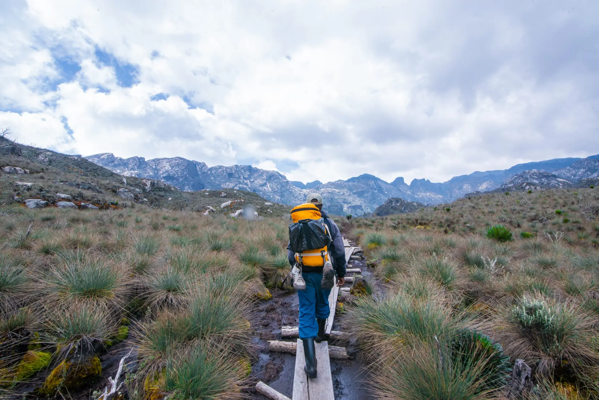
DAY 1: KILEMBE TRAILHEAD → SINE CAMP (~1,450 m → 2,596 m) | ~9.5 km
Hiking time: 5–7 hours | Elevation gain: +1,146 m | Overnight: Sine Camp (2,596 m)
Starting at Kilembe: The Rwenzori’s Southern Gateway
Your 7-day Rwenzori trek to Mount Baker and Weismann’s Peak begins at the Rwenzori Backpackers Hostel (Trekkers Hostel Kilembe) in Kyanjuki, approximately 35km from Kasese town, around 40 minutes by road. Arriving the evening before your start date is strongly advised: guide and porter introductions, permit verification, load allocation, and equipment checks all happen at Kilembe, and a 7:00 AM departure on Day 1 requires the morning to run smoothly. The pre-trek briefing at the trailhead covers route structure, altitude management, emergency protocols, and the specific demands of this two-summit itinerary.
One logistical note that every trekker should understand before departure: this is a point-to-point traverse. You begin at Kilembe and exit via the Nyamwamba Valley on Day 7 at a different trailhead, approximately 20–30 minutes by road from Kilembe. A return vehicle transfer from the Nyamwamba exit back to Kasese or your accommodation must be pre-arranged. We coordinate the transfer as part of our service.
The Afro-Montane Forest Ascent
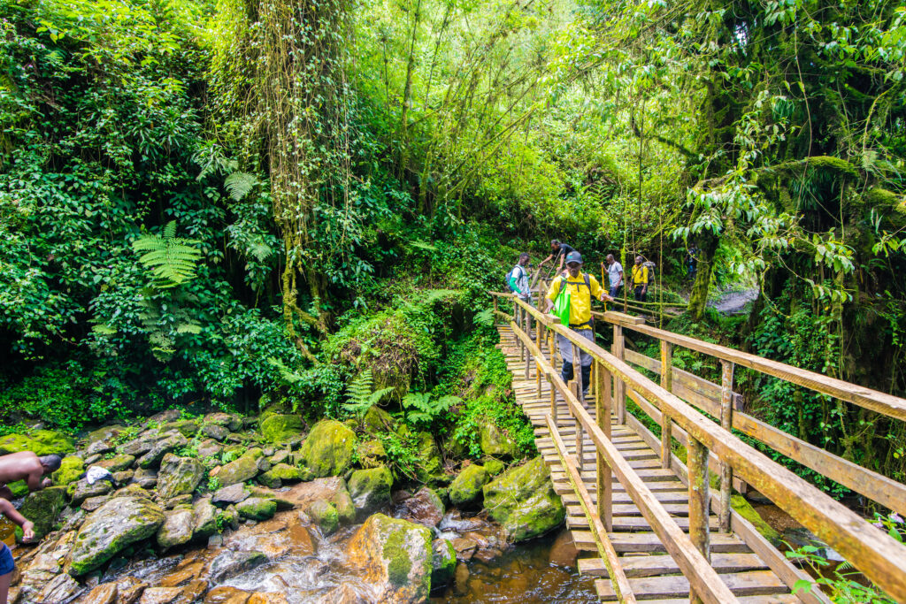
The trail departs immediately into the lower Nyamwamba Valley forest. The approach is steep from the first few metres, with no warm-up flat section on the Kilembe Trail. The forest at this elevation is ancient Afro-montane rainforest: towering hardwoods draped in epiphytic moss and lichen, the understory rich in ferns, orchids, and flowering shrubs. Rwenzori Mountains National Park (a UNESCO World Heritage Site) has protected this valley since 1994, and the forest here has the density and quiet of genuinely undisturbed habitat.
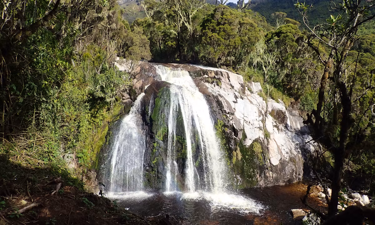
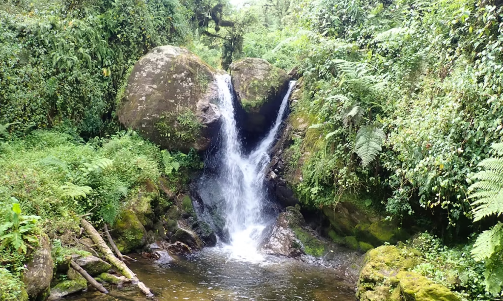
Primate activity is excellent in the lower Nyamwamba Valley. Black-and-white colobus monkeys (Colobus guereza) move through the upper canopy; blue monkeys (Cercopithecus mitis) forage in mixed groups; the L’Hoest’s monkey (Allochrocebus lhoesti), a species held sacred by the Bakonzo people as a guardian of tradition, is occasionally spotted in family groups along the trail. Distant chimpanzee vocalizations sometimes echo across the valley from adjacent forests. A short detour near the 2,000m mark leads to Enock’s Falls, a beautiful cascade framed by dense riparian vegetation, well worth the extra ten minutes.

The trail gains altitude steadily through the forest, crossing several clear mountain streams before the vegetation begins the transition to bamboo above 2,000m. After 5–7 hours, Sine Camp (2,596m) is reached in a sheltered clearing beside a stream, surrounded by the first tree heather pushing through the upper bamboo. Dinner is a full hot three-course meal; night temperatures of 10–14°C make this the most comfortable camp of the expedition.
Day 1 Highlights
- Briefing and departure from Rwenzori Backpackers Hostel, Kilembe
- Lower Nyamwamba Valley forest colobus, blue and L’Hoest’s monkeys
- Enock’s Falls accessible on a short detour from the main trail
- Rich botanical diversity: moss-draped hardwoods, orchids, giant ferns, bamboo
- Overnight at Sine Camp (2,596 m) the warmest and most comfortable camp on the route
DAY 2: SINE CAMP → MUTINDA CAMP (2,596 m → 3,582 m) | ~6.1 km
Hiking time: 6–8 hours | Elevation gain: +986 m | Overnight: Mutinda Camp (3,582 m)
Bamboo Zone, Ridge Crossings, and Kalalama Camp
Breakfast at Sine Camp by 7:00 AM and departure by 7:30. Day 2 of the Mount Baker and Weismann Peak trek begins in the Bamboo-Mimulopsis Zone, a dense stand of mountain bamboo (Arundinaria alpina) whose tall culms create a green tunnel effect as the trail climbs steeply in the morning. In the wet season, this zone is famously muddy and slippery; in drier conditions, the going is firm but always steep. Three-horned chameleons (Trioceros johnstoni), an endemic Rwenzori species, are routinely spotted on bamboo stems at eye level, their otherworldly coloring perfectly suited to the green, filtered light.
Above the bamboo, the trail enters the Heather-Rapanea Zone at approximately 2,900 m. Tree heather (Erica arborea and Erica trimera) covered in Usnea lichen takes the place of the bamboo canopy; the landscape becomes more shaped and open, with ridge crossings giving short panoramic views back down the Nyamwamba Valley. Kalalama Camp (3,147 m), a small rest shelter beside a mountain stream, is a welcome midday stop for hot drinks and lunch. The 551m gain from Kalalama to Mutinda Camp in 1.8km is one of the steeper sustained climbs on the route, but the transition from heather forest to the first open alpine views makes it entirely worthwhile.
Optional: Mutinda Lookout Acclimatisation Hike
Mutinda Camp (3,582m) sits beside a mountain stream in a sheltered alpine bowl. After arriving in the early afternoon, your guide will offer an optional acclimatization hike to Mutinda Lookout (3,975m), which involves a 387m gain and takes 2–3 hours for the return trip. From the lookout on a clear afternoon, you can see the Rwenzori high peaks spread before you; Kasese town is visible far below in the Western Rift Valley; Lake George is on the horizon; and you get your first clear view of Mount Baker and Weismann’s Peak, the two summits you will stand on in four days.
Anyone taking the altitude challenge seriously should strongly recommend this acclimatization hike and not treat it as optional. The ‘climb high, sleep low’ principle, gaining altitude during the day and then descending to sleep lower, is the most effective single strategy for reducing altitude sickness risk. The Mutinda Lookout hike is the primary built-in altitude buffer on this itinerary. See the full Rwenzori acclimatization guide for the complete altitude management strategy.
Day 2 Highlights
- Bamboo-Mimulopsis Zone: dense bamboo tunnels and three-horned chameleons
- Heather-Rapanea Zone lichen-draped tree heather and ridge panoramas
- Kalalama Camp (3,147m) mid-day rest stop with waterfalls nearby
- Optional Mutinda Lookout acclimatisation hike (3,975 m): first views of Baker and Weismann’s
- Overnight at Mutinda Camp (3,582m)
DAY 3: MUTINDA CAMP → BUGATA CAMP (3,582 m → 4,100 m) | ~8.6 km
Hiking time: 4–6 hours | Elevation gain: +518 m | Overnight: Bugata Camp (4,100 m)
The Afro-Alpine Moorland: Giant Lobelias and Namusangi Valley Waterfalls
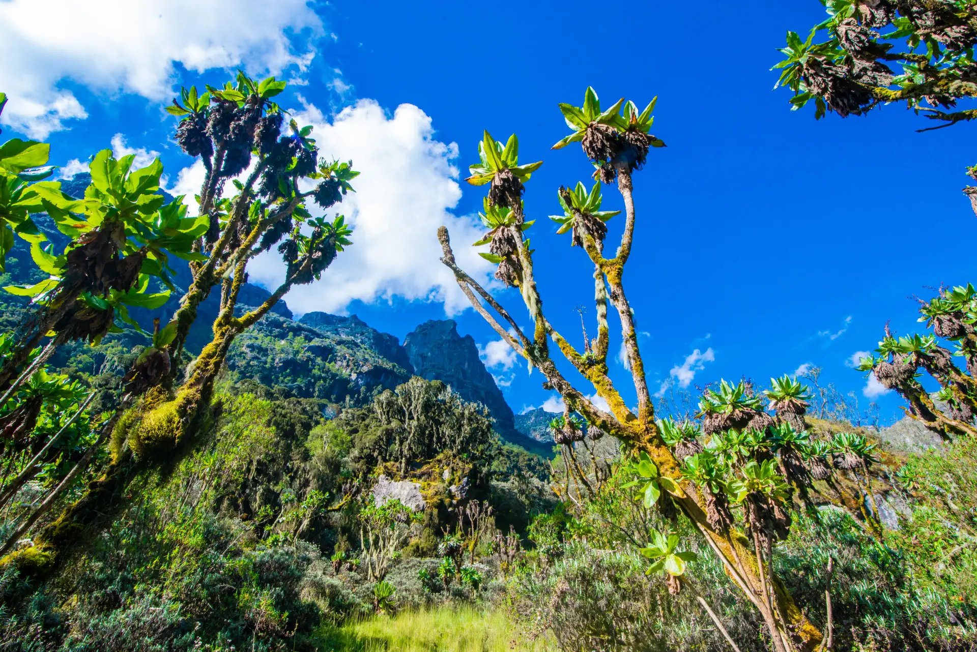
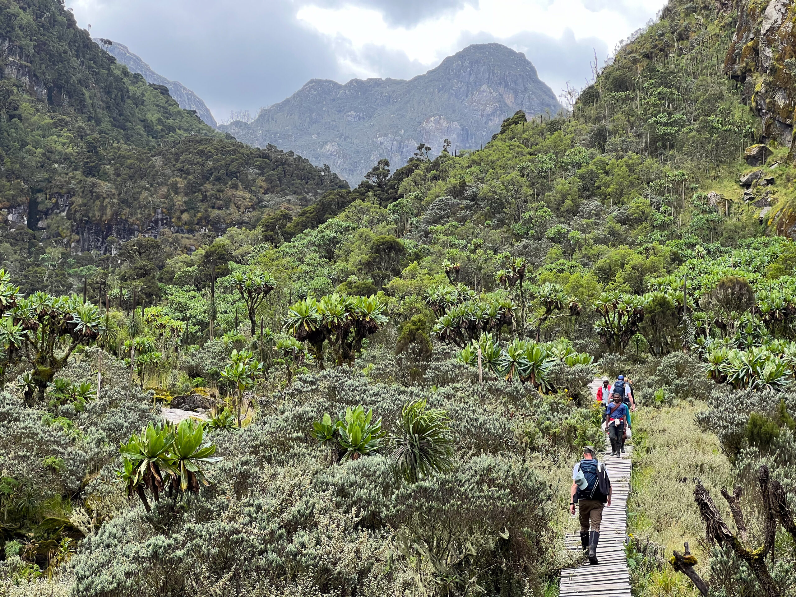
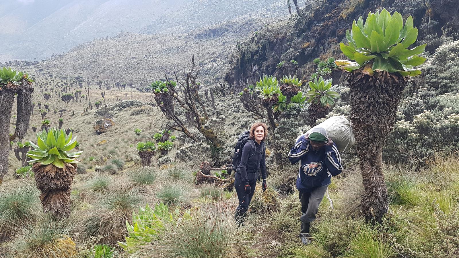
Day 3 is the most visually dramatic day of the ascent, the day the Kilembe Trail leaves the heather forest behind entirely and enters the extraordinary Afro-alpine zone that makes the Rwenzori one of the most botanically remarkable mountains on Earth. Above Mutinda Camp, the trail crosses the open Mutinda Valley, where the ground is carpeted in tussock grass, everlasting flowers (Helichrysum stuhlmannii), and the first giant lobelias (Lobelia wollastonii) growing 4–5 metres tall, their silver rosettes shimmering in the morning light. Giant groundsels (Senecio adnivalis) form stands of architectural plants across the open moorland. Nothing in the lower zones prepares you for this transition.
The route climbs into the Namusangi Valley (approximately 3,840m), one of the most dramatic side valleys on the Kilembe Trail. Vertical waterfalls cascade down sheer rock faces on both sides of the valley, some of them 30–50 metres of continuous white water against dark rock. Looking back across the valley from the upper Namusangi, the silhouettes of the Mutinda Peaks form the skyline behind you. Ahead, the broad sweep of the upper Namusangi Valley opens toward Bugata Camp.
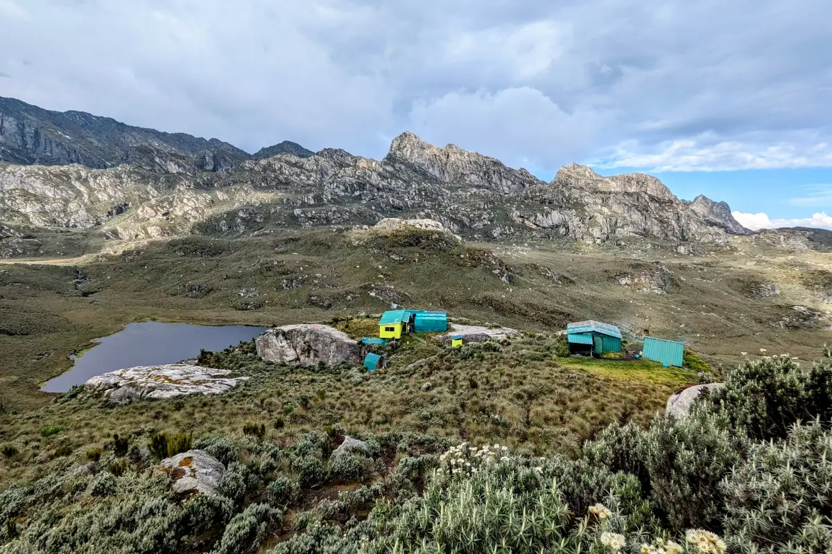
Bugata Camp: The Best-Equipped High Camp on the Kilembe Trail

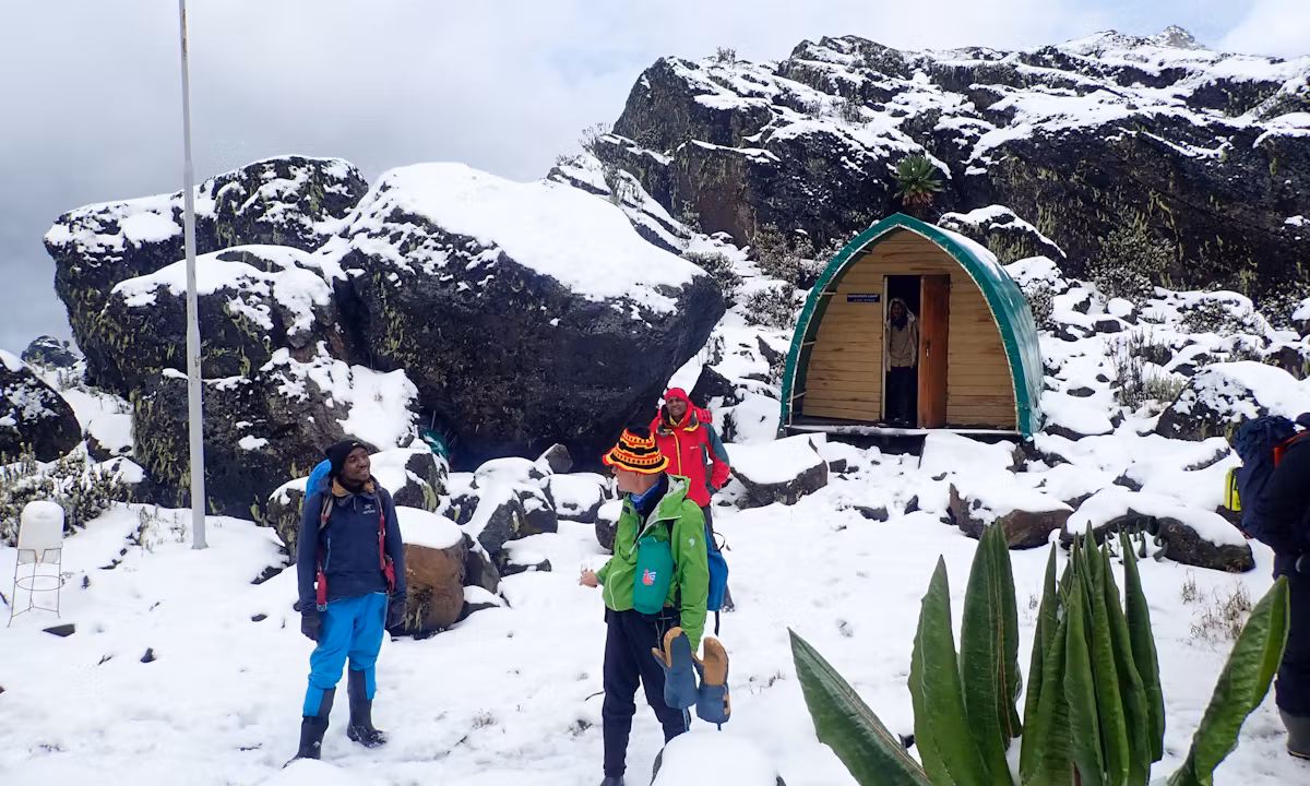
Bugata Camp (4,100m) is exceptional in the Rwenzori context. Unlike most mountain huts, which offer basic sleeping platforms and outdoor cooking facilities, Bugata has solar lighting in the sleeping huts, warm shower facilities (cold by lowland standards but remarkable at 4,100m), a kitchen and dining shelter, composting toilets, and critically, access for emergency helicopter landings. This is where your travel insurance becomes practically relevant: at 4,100m, any medical evacuation is expensive and logistically complex without air access. Review our Rwenzori travel insurance guide before departure to confirm your coverage.
From Bugata, the views are extraordinary. Lake Kopello shimmers in the valley below; the ridgeline above leads the eye directly to Bamwanjara Pass and, beyond it, the central Rwenzori massifs. Mount Baker’s dark rock flanks are visible to the northeast; Weismann’s Peak rises like a blade further along the same ridge. You will stand on both of those summits within 72 hours. The Rwenzori Red Forest Duiker (Cephalophus nigrifrons rubidus), an endemic subspecies, sometimes emerges around Bugata Camp at dusk to feed in the remaining vegetation at the camp margin.
Day 3 Highlights
- Transition into the full Afro-alpine zone: giant lobelias and groundsels
- Namusangi Valley waterfalls some of the most dramatic scenery on the Kilembe Trail
- First close views of Mount Baker and Weismann’s Peak from the upper valley
- Bugata Camp (4,100 m): solar lighting, warm showers, helicopter emergency access
- Rwenzori Red Forest Duiker sightings at camp margins at dusk
DAY 4: BUGATA CAMP → BAMWANJARA PASS → HUNWICK'S CAMP (4,100 m → 4,450 m → 3,974 m) | ~8.3 km
Hiking time: 7–9 hours | Pass gain: +350 m | Net descent to Hunwick’s: −476 m | Overnight: Hunwick’s Camp (3,974 m)
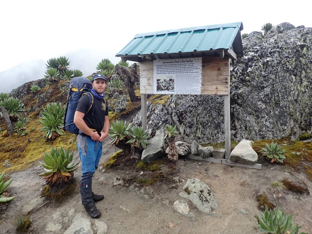
Crossing Bamwanjara Pass (4,450m)
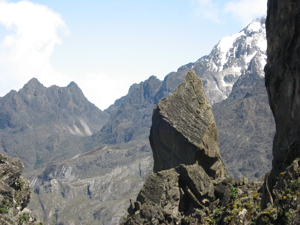
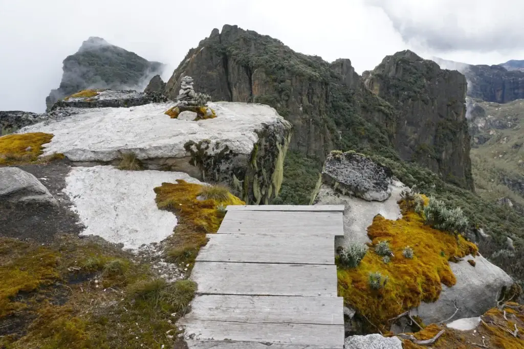
Day 4 is the magnificent crossing, the passage from the Kilembe approach side of the range into the inner Rwenzori world where both summits wait. Breakfast at 6:30 AM and departure by 7:00. From Bugata Camp, the trail climbs a long ridge to Bamwanjara Pass at 4,450m, the highest point of the approach section and one of the most remarkable viewpoints in the Rwenzori Mountains. A small emergency shelter hut marks the pass; in inclement weather it provides a useful windbreak.
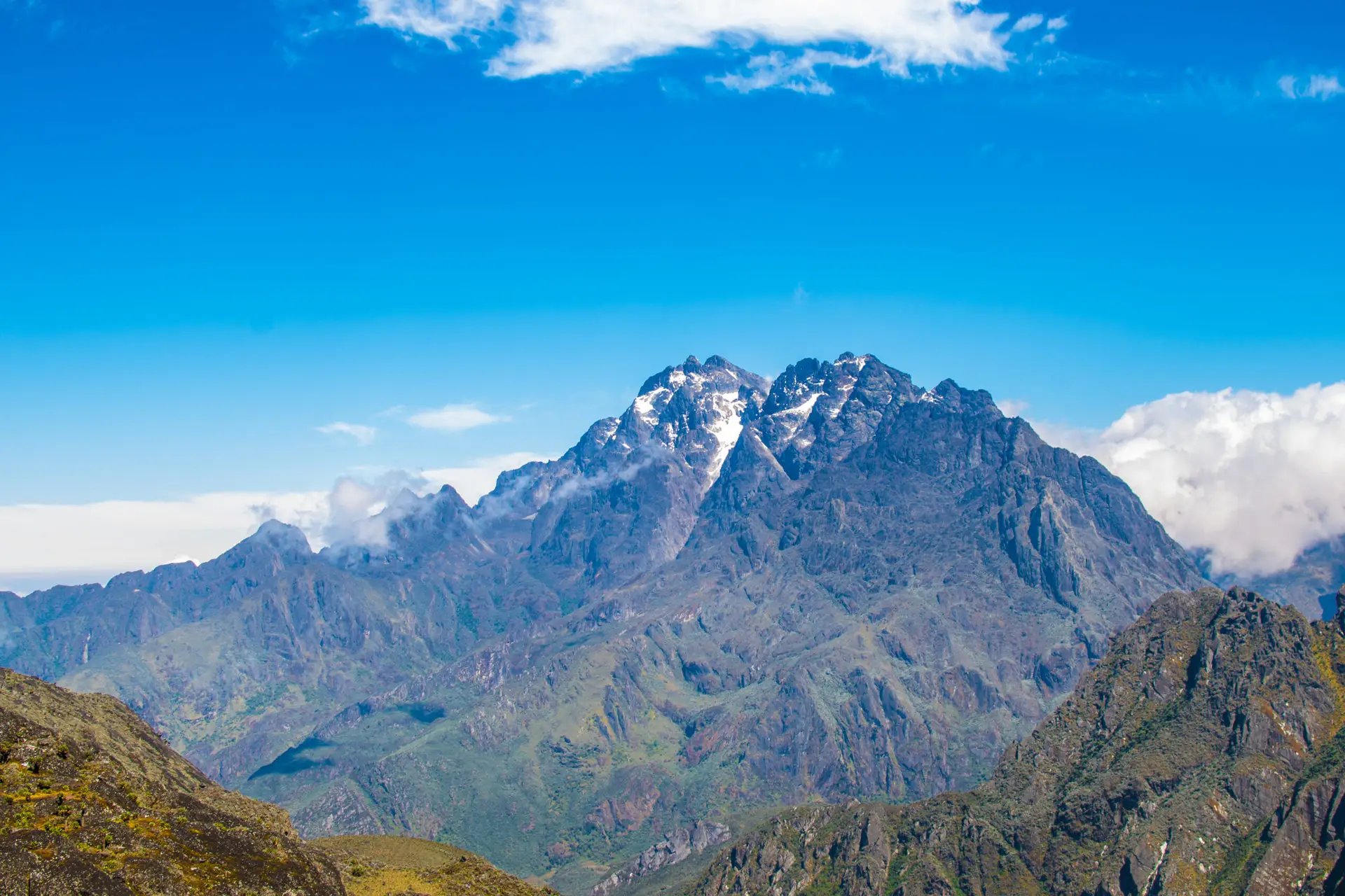
On clear mornings at Bamwanjara Pass, the full panorama of the inner Rwenzori reveals itself simultaneously: Mount Stanley (5,109m) dominates to the northwest, its Stanley Glacier visible as a bright band; Mount Baker (4,843m) stands immediately to the northeast, your first summit target, now close enough to study the approach line; Mount Speke (4,890m) appears to the north; and Weismann’s Peak to the east. For the first time, you can see the full geometry of the expedition, with the two summits laid out before you and separated by one night at Hunwick’s Camp.
Descent to Hunwick’s Camp Through the Alpine Bogs
From the pass, the trail descends into the inner Rwenzori valleys, skirting high-altitude alpine bogs. The Malachite Sunbird (Nectarinia johnstoni), endemic to the Rwenzori and Virunga highlands, breeds and feeds on the giant lobelia flower spikes in this zone; approach the lobelia stands quietly and watch the sunbirds work systematically from flower to flower. Common ravens work the open ground; augur buzzards sometimes soar above the ridge.
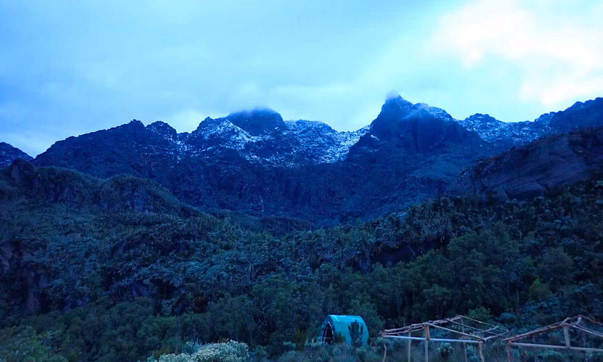
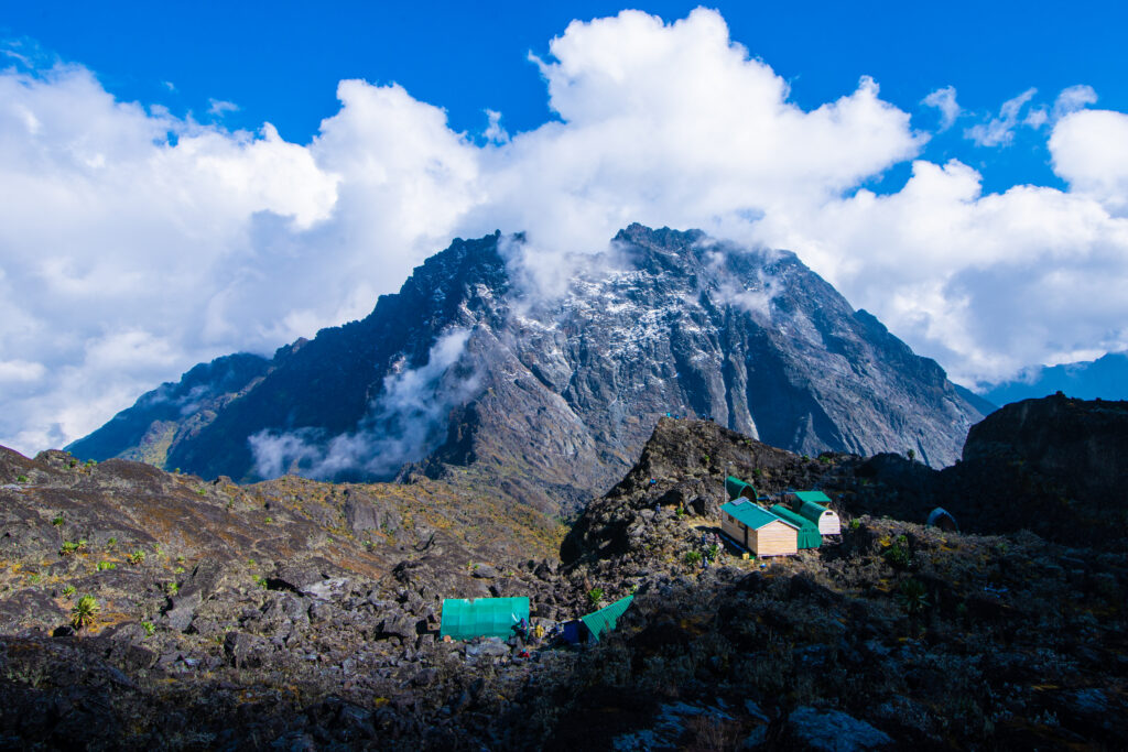
Hunwick’s Camp (3,974m) sits on the rim of a deep valley with a 270-degree panorama of the surrounding massifs. This is the expedition’s base camp for both summit days; you sleep here on Night 4 and Night 5. The additional night here, compared to the 6-day Weismann route, provides a full day’s rest between the Baker summit and the Weismann summit. The hut sleeps 12–16 in bunk platforms with a separate kitchen shelter. Night temperatures regularly drop below 0°C. Every layer you packed is relevant at Hunwick’s.
Day 4 Highlights
- Bamwanjara Pass (4,450 m), the highest point of the approach, with panoramic views of four Rwenzori massifs
- Emergency shelter hut at the pass a useful landmark and weather refuge
- Malachite Sunbird feeding at alpine lobelia stands below the pass
- First simultaneous view of both summit targets: Baker and Weismann’s
- Hunwick’s Camp (3,974 m) summit base camp, 270-degree mountain views, nights 4 and 5
DAY 5: SUMMIT MOUNT BAKER EDWARD PEAK (4,843 m) 3,974 m → 4,843 m → 3,974 m | ~10 km round trip
Hiking time: 6–8 hours | Summit gain: +869m from Hunwick’s | Return to Hunwick’s overnight
Early Departure for Edward Peak
Your guide wakes you at 5:00 AM. Mount Baker summit day begins in the cold and dark of Hunwick’s Camp, with temperatures typically ranging from -3°C to -6°C before sunrise. Dress in full layers before stepping out: thermal base, fleece, insulated jacket, waterproof shell, warm hat, and gloves. Hot drinks and biscuits for breakfast, and then by 5:30–6:00 AM the ascent begins in headlamp beams.
The ascent of Mount Baker to Edward Peak (4,843m) is the most technically demanding section of this entire 7-day expedition. The route climbs steeply from Hunwick’s on rocky, exposed ground. In dry season conditions (January–February, June–August), the rock is firm underfoot, and traction is manageable with sturdy waterproof hiking boots. In wet-season conditions (April–May, September–October), the exposed rock faces can be ice-coated and genuinely hazardous; your guide will deploy safety ropes on the steepest sections regardless of season. This is not a glacier climb, but it is a serious mountain ascent that demands concentration throughout.
The Mount Baker Summit: Edward Peak (4,843m)
Edward Peak is the highest point of Mount Baker at 4,843 m, the Rwenzori’s third-highest summit overall. The final metres to the summit involve a short scramble through a cleft in the granite rock before the summit crest opens. On clear mornings, the view from Edward Peak is among the finest in the Rwenzori range. To the northwest, Margherita Peak (5,109m) and Alexandra Peak (5,091m) on Mount Stanley rise above the clouds; the Stanley Glacier catches the early morning light. To the south, the DRC border is 2.8km away; on exceptionally clear days, the Ruwenzori foothills extend westward into the DRC toward Lake Edward.
The summit is not a place for extended rest; cold, wind, and the descent demand 20–40 minutes at the top. Photographs capture a moment of genuine achievement, as this is Africa’s 10th highest summit, and then the descent begins. The down-climb demands as much focus as the ascent; tired legs on steep, rocky terrain require a deliberate, careful pace. Most parties are back at Hunwick’s Camp for hot lunch by midday.
Rest Afternoon at Hunwick’s Camp
The rest of Day 5 is yours at Hunwick’s Camp, one of the genuine advantages of the 7-day itinerary over the 6-day Weismann’s route. After the Baker summit, the afternoon at 3,974 m gives your body time to process the exertion, rehydrate, eat well, and prepare mentally and physically for tomorrow’s Weismann’s Peak summit. Sleep early; the second summit day begins again before dawn.
Day 5 Highlights
- Pre-dawn ascent of Mount Baker to Edward Peak (4,843 m), Africa’s 10th highest summit
- Safety ropes on steep rocky sections (deployed by guide as standard practice)
- Summit views: Margherita Peak, Stanley Glacier, and the DRC border landscape
- Return to Hunwick’s Camp for hot lunch and full rest afternoon
Second overnight at Hunwick’s Camp the dual-summit staging strategy
DAY 6: WEISMANN'S PEAK VIA OLIVER'S PASS → KIHARO CAMP (3,974 m → 4,620 m → 3,460 m) | ~15.8 km
Hiking time: 9–12 hours | Summit gain: +646m from Hunwick’s via Oliver’s Pass | Descent to Kiharo: −1,160m | Overnight: Kiharo Camp (3,460m)
The Second Summit: Weismann’s Peak via Oliver’s Pass
Day 6 is structured differently from Day 5. Rather than an out-and-back summit, today combines a summit attempt with the beginning of the long descent out of the inner Rwenzori, meaning you carry your full gear and do not return to Hunwick’s. Departure is at 5:30 AM, and it will again be in headlamp conditions. The route from Hunwick’s Camp initially follows the trail toward Oliver’s Pass rather than the Baker approach line, moving across the inner mountain terrain in a different direction from yesterday.
Oliver’s Pass is a narrow saddle between ridges at approximately 4,200m, 3km from Hunwick’s Camp. The ascent to Weismann’s Peak (4,620m) from Oliver’s Pass involves steep but manageable rocky terrain, the same character as the Baker approach but without the ice-risk sections. The route runs via McConnell’s Prong, a rocky ridge providing the direct line to the summit. No ropes are typically required in dry conditions; in the wet season, your guide makes the call on-site.
Standing on Weismann’s Peak (4,620m)
The summit of Weismann’s Peak is a narrow rocky crest with exposure on all sides. The view from here differs from Baker’s summit in revealing ways; instead of looking across at Weismann’s as you did yesterday, you now look back at Baker. The geometric relationship between the two peaks, seen from opposite sides in consecutive mornings, is one of the defining memories of this two-summit expedition. To the northwest, Margherita Peak is again visible; to the south, the Kitandara Lakes basin shimmers in the morning light. The Virunga volcanoes are sometimes visible on the DRC horizon.
Weismann’s Peak, at 4,620m, is the 11th highest summit in Uganda. Standing here the day after Edward Peak (the 10th highest) means you have, in 48 hours, stood on Uganda’s 10th and 11th highest summits. For trekkers pursuing a Rwenzori peak-bagging program, this climb is a meaningful double. The first part of Day 6 lasts twenty to forty minutes, after which the long descent begins.
Descent to Kiharo Camp via the Kitandara Basin
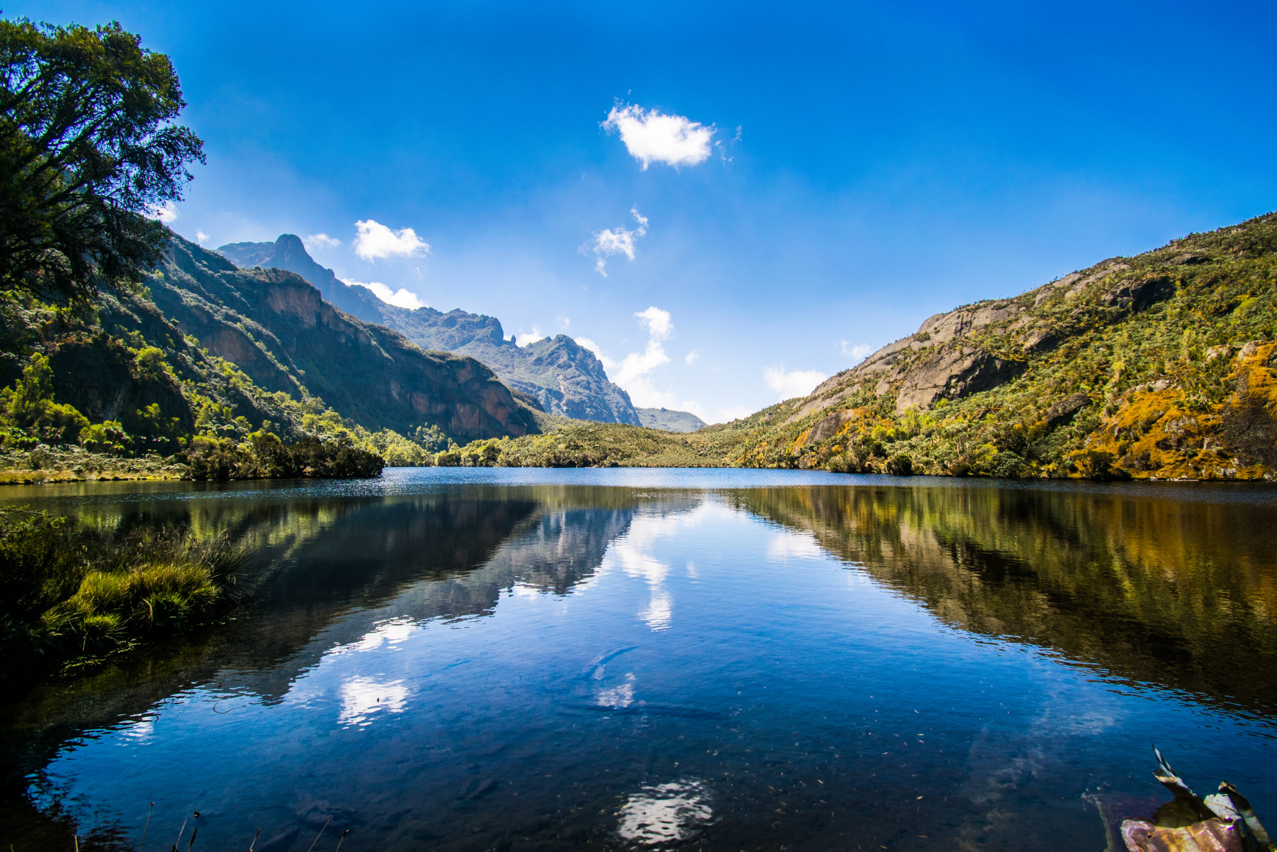
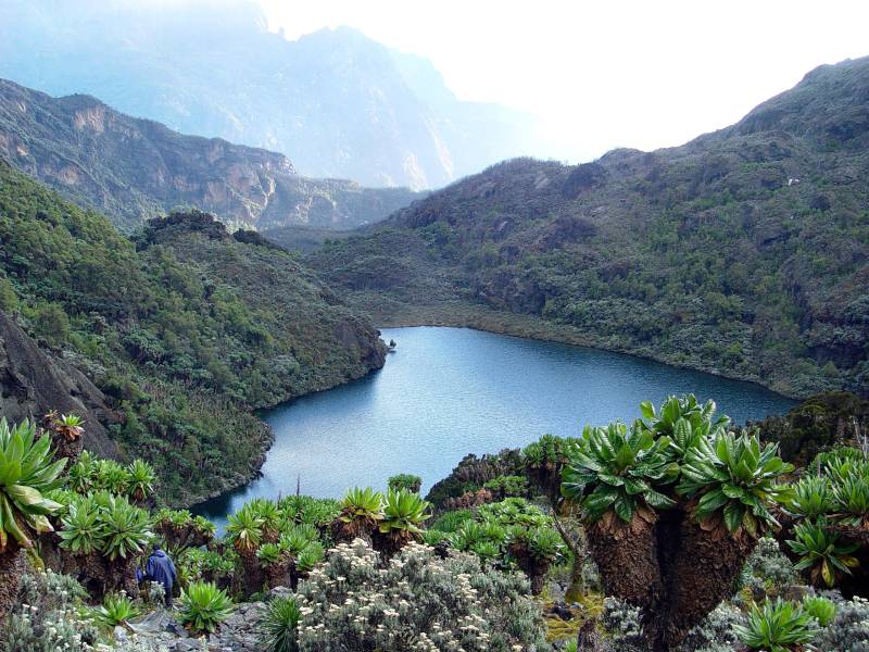
From Weismann’s Peak, the descent route enters the upper Nyamwamba Valley via the Kitandara basin, one of the most visually spectacular alpine valleys in the Rwenzori Mountains. The Kitandara Lakes (also visited on the Central Circuit Trail) sit at approximately 4,023m in a glacially carved bowl, their dark water perfectly still when the air is calm. Giant groundsels and lobelias crowd the lake margins. Rock hyraxes call from surrounding boulder fields.
Continuing down through the upper Nyamwamba Valley, the landscape transitions from glacial moraine and high alpine bog through diminishing vegetation toward the first sub-alpine scrub. Rwenzori Red Forest Duikers become more visible in the vegetation margins as altitude drops. Kiharo Camp (3,460 m) is nestled in dense evergreen vegetation beside a rushing stream, a sheltered, forested contrast to the wide-open exposure of Hunwick’s Camp. By the time you arrive, two summits are behind you. That reality takes a while to absorb.
Day 6 Highlights
- Pre-dawn departure for Weismann’s Peak via Oliver’s Pass
- Summit of Weismann’s Peak (4,620 m) via McConnell’s Prong Uganda’s 11th highest summit
- Looking back at Mount Baker’s summit from Weismann’s, the two-summit perspective
- Kitandara Lakes basin glacially carved alpine lakes at 4,023m
- Descent through glacial moraine and upper Nyamwamba Valley
- Overnight at Kiharo Camp (3,460 m), a sheltered, forested, post-summit sanctuary
DAY 7: KIHARO CAMP → NYAMWAMBA VALLEY EXIT → KILEMBE BASECAMP (3,460 m → ~1,480 m) | ~16 km
Hiking time: 7–8 hours | Elevation loss: −1,980m | End of expedition
The Nyamwamba Valley Gorge: A Grand Finale
Day 7 of the Mount Baker and Weismann Peak expedition is a long, physically demanding descent and one of the most scenically rewarding final days of Rwenzori trekking. The Nyamwamba Valley gorge, carved by glacial meltwater over millennia into the ancient crystalline rock of the Rwenzori Mountains, is a succession of powerful waterfalls, moss-covered canyon walls, deep forest gorges, and multiple river crossings that require careful footwork even when your legs are weary. The path follows the valley floor in places and traverses high above it on rocky ledges in others; the contrast between the two environments, intimate and enclosed versus exposed and vertiginous, is part of what makes this descent exceptional.
Wildlife activity increases with every 100m of lost altitude. Rwenzori Red Forest Duikers move through the understory; rock hyraxes (Procavia capensis) colonize every boulder field; colobus monkeys and blue monkeys return to the canopy above 2,500m. The sound of the forest bird calls multiplying and the occasional crash of a startled duiker in the undergrowth grows richer as the mountain forest re-establishes itself around the trail.
Riverside Rock Shelter and the Final Forest
Lunch is taken at Riverside Rock Shelter, a natural overhang beside the river that serves as the traditional Day 7 rest point. The water’s sound and the rock’s cool shade make it one of the most restorative lunch stops on any Rwenzori route. Beyond the shelter, the trail continues down through the final forest section, crossing the river for the last time before the park boundary and the exit point.
The Nyamwamba Valley exit point is where your return vehicle waits, pre-arranged as part of your expedition logistics. The transfer back to Kilembe, Kasese, or onward to Fort Portal takes 20–40 minutes, depending on the destination. At the exit, this is the moment for photographs with your guide and porter team, for the tipping ceremony (see our Rwenzori tipping guide), and for the cold drink that has been somewhere in your thoughts since Bamwanjara Pass. You have climbed two of Uganda’s top eleven summits in the last 48 hours. That deserves a moment.
Day 7 Highlights
- The Nyamwamba Valley gorge waterfalls, moss-covered rock, and deep forest
- Increasing wildlife activity: duikers, hyraxes, primates, and rich birdlife at lower altitude
- Lunch at Riverside Rock Shelter beside the river
- Exit at the Nyamwamba Valley trailhead; farewell to your mountain team
- Vehicle transfer to Kasese, Fort Portal, or onward destinations
Elevation Profile: 7-Day Mount Baker & Weismann Peak Trek.
The elevation arc of this expedition is front-loaded, double-peaked, and resolves in a long final descent. The ascent profile across Days 1–4 is identical to the 6-day Weismann’s Peak route: Day 1 gains 1,146m (Kilembe ~1,450m to Sine Camp 2,596m), Day 2 gains 986m (to Mutinda Camp 3,582m), Day 3 gains 518m (to Bugata Camp 4,100m), and Day 4 crosses Bamwanjara Pass (4,450m) before descending 476m to Hunwick’s Camp (3,974m).
The 7-day itinerary diverges from the 6-day at this point. Day 5 pushes 869m above Hunwick’s to the summit of Edward Peak on Mount Baker (4,843m) before returning to Hunwick’s (−869m). This is the highest point of the entire expedition. Day 6 climbs 646m to Weismann’s Peak (4,620m) via Oliver’s Pass before a 1,160m descent to Kiharo Camp (3,460m). Day 7 completes the descent with a 1,980m drop to the Nyamwamba Valley exit (~1,480m). Total cumulative ascent: approximately 4,369m. Total cumulative descent: approximately 4,369m.
| Day 1 Start | Kilembe Trailhead: ~1,450m |
| Day 1 End | Sine Camp: 2,596m (+1,146m) |
| Day 2 End | Mutinda Camp: 3,582m (+986m) |
| Day 2 Optional | Mutinda Lookout: 3,975m (+393m from camp, return) |
| Day 3 End | Bugata Camp: 4,100m (+518m) |
| Day 4 High Point | Bamwanjara Pass: 4,450m (+350m from Bugata) |
| Day 4 End | Hunwick’s Camp: 3,974m (−476m from pass) |
| Day 5 Summit | Edward Peak, Mount Baker: 4,843m (+869m) expedition high point |
| Day 5 Return | Hunwick’s Camp: 3,974m (−869m, same overnight) |
| Day 6 Summit | Weismann’s Peak: 4,620m (+646m) |
| Day 6 End | Kiharo Camp: 3,460m (1,160m from summit) |
| Day 7 End | Nyamwamba Valley Exit: ~1,480m (−1,980m) |
| Total Ascent | ~4,369 m cumulative |
| Total Descent | ~4,369 m cumulative |
| Route Type | Point-to-point traverse (different start and finish points) |
Mountain Camps & Accommodation on the 7-Day Route
Sine Camp 2,596m (Day 1 Overnight)
The standard first overnight is on all Kilembe Trail itineraries. Sine Camp at 2,596m occupies a sheltered clearing at the transition between upper bamboo and lower tree heather, beside a brisk mountain stream. Sleeping hut platforms for 12–16 people, a separate kitchen shelter, and basic toilet facilities are provided. Night temperatures of 10–14°C were the warmest in the camp of the expedition. A short walk from camp leads to views over the Nyamwamba Valley below.
Mutinda Camp, 3,582 m (Day 2 Overnight)
Mutinda Camp sits in a wide sheltered bowl beside a mountain stream at 3,582m, framed by tree heather and the first alpine plants. Sleeping hut platforms for 12–16, a kitchen and dining shelter, and basic toilet facilities. Night temperatures are 4–8°C; a proper sleeping bag layer is required from this camp. The optional afternoon acclimatization hike to Mutinda Lookout (3,975 m) departs from here and is strongly recommended for altitude preparation.
Bugata Camp 4,100 m (Day 3 Overnight)
The best-equipped high camp on the Kilembe Trail has solar-lit sleeping huts, warm shower facilities, a kitchen and dining shelter, composting toilets, and emergency helicopter landing access. Views across Lake Kopello and directly up at Mount Baker and Weismann’s Peak. Night temperatures are 0–4°C; a sleeping bag rated to 0°C is essential. Insurance documentation becomes practically important here; see the guide for Rwenzori travel insurance.
Hunwick’s Camp, 3,974 m (Nights 4 and 5 Baker & Weismann Staging Camp)
Hunwick’s Camp is the expedition’s summit base, where you sleep twice: once before the Baker summit and once before the Weismann summit. Perched on the rim of a deep inner valley at 3,974m with a 270-degree panorama of the central Rwenzori massifs. Sleeping platforms for 12–16, kitchen shelter, basic toilet facilities. Night temperatures are consistently below 0°C; sleeping bags rated to -5°C are recommended. The dramatic, exposed position of this camp, open to the mountain on three sides, makes it one of the most memorable overnight experiences in Rwenzori trekking. The two-night stay is one of the distinctive advantages of this itinerary: you summit Baker fresh, rest, and then summit Weismann’s the following day.
Kiharo Camp, 3,460 m (Day 6 Overnight)
Kiharo Camp, at 3,460m is nestled in dense evergreen vegetation beside a rushing stream, a more sheltered, forested environment than Hunwick’s, where rock hyraxes call from surrounding boulders at dusk. Sleeping hut platforms for 12–16, kitchen shelter, and basic facilities. Night temperatures are 4–8°C. Most trekkers sleep better at Kiharo than anywhere since Sine Camp; the combination of lower altitude, post-summit physical exhaustion, and the sheltered forest environment induces the deepest sleep of the expedition.
Flora & Wildlife: What You’ll Encounter on the 7-Day Route
The Rwenzori Mountains are a UNESCO World Heritage Site partly because of their extraordinary biological diversity: five distinct vegetation zones stacked between 1,400m and 5,109m. This 7-day route traverses all five, plus the Nyamwamba Valley gorge on the descent, which adds a sixth ecological dimension.
Afro-Montane Forest (1,400–2,500 m) Days 1 & 7.
The lower Nyamwamba Valley hosts some of the richest Rwenzori wildlife on the Kilembe Trail. Researchers regularly encounter black-and-white colobus monkeys (Colobus guereza), blue monkeys (Cercopithecus mitis), and L’Hoest’s monkeys (Allochrocebus lhoesti). Rwenzori turacos (Tauraco johnstoni) with their crimson wing flash are the bird highlight; Hartlaub’s duck is found along streams. On Day 7’s descent, primate and bird diversity increase markedly as altitude drops through the forest zones.
Bamboo Zone (2,200–2,800 m) Days 1–2
Mountain bamboo (Arundinaria alpina) forms a distinctive corridor above the mixed forest. Three-horned chameleons (Trioceros johnstoni), a Rwenzori endemic, are most commonly spotted at bamboo level, on stems at eye level. Approach slowly and scan carefully for the distinctive triangular head shape.
Heather-Rapanea Zone (2,800–3,500 m) Days 2–3
Tree heather (Erica arborea and Erica trimera) draped in Usnea lichen (‘old man’s beard’) forms the most visually distinctive mid-altitude zone along the Kilembe Trail. The Rwenzori nightjar, several sunbird species, and common ravens inhabit this zone. The sculptural quality of ancient lichen-covered heather in morning mist is one of the most photographed environments on the route.
Afro-Alpine Moorland (3,500–4,500 m): Days 3–6
The Rwenzori’s most globally iconic ecological zone is dominated by giant lobelias (Lobelia wollastonii and Lobelia bequaertii), giant groundsels (Senecio adnivalis), and everlasting flowers (Helichrysum stuhlmannii), which together dominate the open moorland. The Malachite Sunbird (Nectarinia johnstoni), endemic to the Rwenzori and Virunga highlands, breeds and feeds on lobelia spikes and is one of the signature bird sightings on this route. The Rwenzori Red Forest Duiker (Cephalophus nigrifrons rubidus) is seen at camp margins. Read the complete Rwenzori vegetation zones guide for the full botanical breakdown.
Summit/Nival Zone (4,500 m+) Days 5 & 6
Above 4,500m, vegetation is essentially absent. Birdwatchers sometimes see common ravens and augur buzzards (Buteo rufofuscus) soaring above both summit ridges. The glaciers of Mount Stanley are visible from both Baker and Weismann’s on clear days, as increasingly rare equatorial ice fields retreat at a documented accelerating rate.
Physical Difficulty & Fitness Requirements
The 7-day Mount Baker and Weismann Peak trek is rated Hard, more demanding than the 6-day Weismann’s route because of the addition of the Baker summit day, the two-night stay at altitude at Hunwick’s Camp, and the overall greater cumulative distance and ascent. Read the full Rwenzori trekking difficulty guide before deciding if this route is right for you.
Who This Trek Is Suited For
- Experienced multi-day trekkers who have completed at least 3–4 trips of 4+ days in the past 18 months
- Trekkers comfortable with 7–10 hours of daily hiking on steep, uneven, and often wet terrain
- Anyone with prior experience above 3,500m who has managed altitude well
- People specifically trained for mountain movement: loaded pack hiking, hill repeats, stair training
- Trekkers who want two named summits without glacier equipment or technical climbing
- Older trekkers who are specifically fit should see our guide for hikers over 50 and 60.
Key Physical Challenges on This Route
- Day 1: +1,146m elevation gain, the steepest single ascent day of any standard Rwenzori itinerary
- Day 5: Baker summit steep, rocky ascent requiring sure-footedness; safety ropes used on exposed sections
- Day 6: 9–12 hours total; summit + 1,160m descent to Kiharo carrying full kit the longest and most demanding day
- Day 7: 16km descent over 1,980m on rocky, rooted, wet valley trail physically taxing on tired legs
- Two nights at 3,974m at Hunwick’s Camp, with cumulative altitude exposure higher than on single-night routes
- Point-to-point structure: no easy bailout to the same trailhead if conditions deteriorate
The Specific Demands of Mount Baker’s Summit
Mount Baker’s Edward Peak requires a note beyond the general difficulty assessment. The summit approach involves steep, rocky ground with sections of genuine exposure and a significant drop on one or both sides. Your guide uses safety ropes on the most exposed sections as standard practice (not as a sign of exceptional danger, but as appropriate caution at 4,800 m+). In wet season conditions (April–May, September–October), the rock faces can be ice-coated, increasing the technical demands significantly. Our guides carry ropes on every Baker summit attempt and deploy them without hesitation when conditions require.
Altitude Considerations
The maximum elevation on this trek is 4,843m at Edward Peak, well above the 4,000m threshold where serious altitude illness becomes a real risk. The two-night stay at Hunwick’s Camp (3,974m) is a significant cumulative altitude exposure. The Mutinda Lookout acclimatization hike on Day 2 afternoon is the primary built-in altitude buffer; do not skip it.
Key altitude rules: walk at the guide’s pace without exception; drink 3–4 liters of water per day; eat full meals regardless of appetite; and report any worsening symptoms immediately. Discuss Acetazolamide (Diamox) prophylaxis with your physician before departure. See the full Rwenzori altitude acclimatization guide and the complete Rwenzori medical guide.
Best Time to Trek to Mount Baker & Weismann Peak via the Kilembe Trail
The Rwenzori Mountains receive precipitation year-round. ‘Best season’ means relatively drier and more stable, not dry. For the full month-by-month breakdown, see our best time to visit the Rwenzori guide.
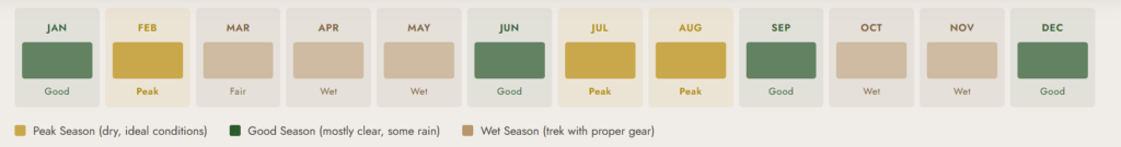
Primary Dry Window: January–February
January and February offer the most stable conditions on both the Kilembe Trail and Baker’s summit approach. Rock surfaces are firmest, Bamwanjara Pass is most reliably navigable, and summit views are the clearest. This period is the recommended peak season for this route.
Secondary Dry Window: June–August
June–August is the second most reliable window. Conditions are generally drier than the wet season, though variable. Baker’s summit approach is manageable with experienced guidance during this period. Early morning starts reduce exposure to afternoon cloud and rain buildup.
Wet Season: March–May and September–October
The wet seasons bring heavier rainfall, muddier trails, and, critically for Baker, ice-coated rocks on the summit approach. The 7-day Baker and Weismann Trek is technically possible year-round with experienced guides, but the Baker summit in the wet season requires significantly more caution and guide expertise on the roped sections. We strongly recommend booking dry-season dates for this particular itinerary. Speak to our guides about current conditions before any wet-season booking.
⚠️ NOTE ON BAKER IN WET SEASON:
Edward Peak’s summit approach can have genuinely icy rock faces in April–May and September–October. Our guides carry and deploy safety ropes as standard on all Baker summit attempts, but wet-season conditions increase technical difficulty meaningfully. If the wet season is your only option, please have an open discussion with our guide team before confirming.
What’s Included in the 7-Day Mount Baker & Weismann Peak Package
Included
- All Uganda Wildlife Authority (UWA) park entry fees and hut fees for 7 days
- Professional certified Kilembe Trail mountain guide (English-speaking, Baker-summit experienced)
- Assistant guide for groups of 4 or more
- Mountain chef and full catering: all meals from Day 1 lunch to Day 7 lunch
- One porter per trekker (carrying up to 15kg of communal gear and your pack)
- Accommodation in mountain huts: Sine, Mutinda, Bugata, Hunwick’s (×2), and Kiharo
- Safety ropes for Baker summit and Weismann’s exposed sections (deployed by guide)
- Free loan of rubber boots (gumboots) for lower forest sections
- Sleeping mats in all huts
- First aid kit and emergency communication equipment carried at all times
- Porter wages, meals, and accommodation throughout the trek
Not Included
- International flights and Uganda visa fees
- Pre- or post-trek accommodation in Kasese or Fort Portal
- Transfer to Kilembe Trailhead or from Nyamwamba Valley exit (can be arranged; ask us)
- Comprehensive travel insurance with altitude to 5,000m+ and medical evacuation MANDATORY
- Tips for guides and porters (see tipping guide for recommended amounts)
- Personal trekking clothing, sleeping bag, and hiking boots
- Bottled water, soft drinks, or alcohol
- Any costs from itinerary changes due to weather, illness, or force majeure
⚠️ INSURANCE MANDATORY:
Bugata Camp (4,100 m) has emergency helicopter access. Hunwick’s Camp (3,974 m) requires a ground carry for evacuation if weather conditions prevent helicopter access. All trekkers must hold comprehensive travel insurance, including altitude coverage to 5,000 m+ and medical evacuation. No insurance = no departure.
Full Packing & Gear List: 7-Day Mount Baker & Weismann Peak Trek
The Kilembe Trail shares the Rwenzori’s defining characteristic: permanent, total moisture. Add to this trek the dual-summit demands of two pre-dawn starts in temperatures below -3°C, one set of safety-rope sections on Baker, and a full 7-day point-to-point traverse, and the need for comprehensive, redundant gear becomes clear. Study the full Rwenzori packing list, the footwear guide, and the cold-weather layering guide before departure.
Clothing The 7-Day Layering System
- Moisture-wicking thermal base layer (top and bottom): minimum 2 full sets
- Mid-layer fleece or lightweight down jacket
- Heavy insulated jacket (down or synthetic) essential for both summit mornings and Hunwick’s nights
- Waterproof shell jacket (Gore-Tex or equivalent) mandatory, not negotiable
- Waterproof shell trousers
- Knee-length gaiters to keep mud out of boots on steep, wet ascents
- 2 pairs of quick-drying trekking trousers
- Warm beanie and balaclava (both summit mornings start in pre-dawn cold)
- Inner liner gloves and waterproof outer gloves
- Minimum 4 pairs of wool or synthetic trekking socks, a dry pair for each summit morning
Footwear
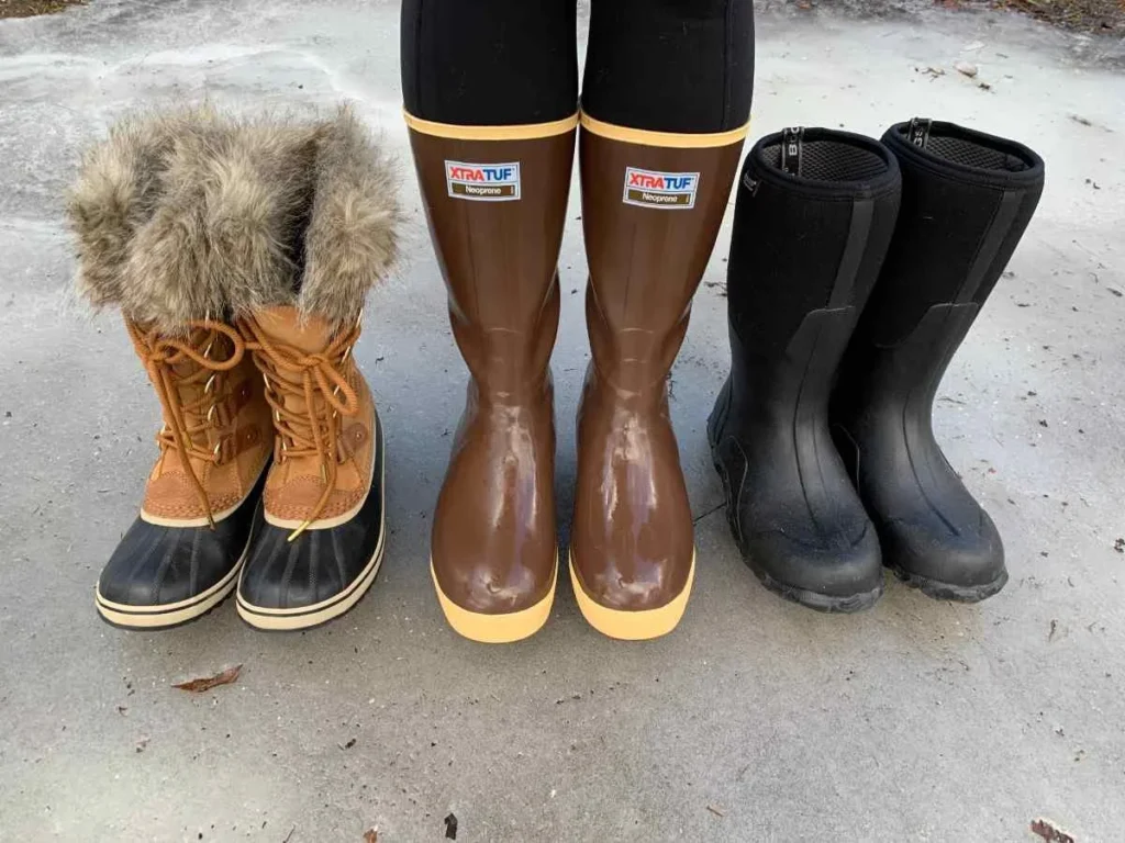
Rubber gumboots (provided free of charge) for the lower forest and bog sections. Waterproof hiking boots with solid ankle support and rigid soles for Days 3–7, including both summit days. No crampons are required; both Baker and Weismann are trekking summits, not glaciated technical climbs. In the wet season, your guide’s ropes manage the iced sections on Baker. The complete Rwenzori footwear guide covers boot selection and rubber boot sizing in full.
Equipment
- Two telescopic trekking poles used constantly on all 7 days; they were essential on Day 7 descent
- Headlamp with fresh batteries + TWO spare sets (two pre-dawn summit departures)
- Sleeping bag rated to -5°C (comfort rating Hunwick’s two nights regularly below 0°C)
- Sleeping bag liner for additional warmth at higher camps
- Waterproof dry bags for all electronics and clothing inside main pack
- Main pack (40–50 L) for porter-carried items
- Summit daypack (20–25L) for personal items, water, snacks, and summit layers
- Water bottles or hydration bladders with a minimum 2-liter capacity
- Water purification tablets as backup
- UV-protective sunglasses (high-altitude sun is intense on both summit days)
- High-SPF sun cream and SPF lip balm
Health & Personal Items
- Personal prescription medications and altitude medication (discuss with doctor pre-departure)
- Personal first aid: ibuprofen, paracetamol, blister plasters, antiseptic cream, rehydration salts
- Foot care: moleskin and blister prevention balm (7 days of moisture = significant blister risk)
- High-energy summit snacks for both summit mornings: energy bars, nuts, chocolate, dried fruit
- Electrolyte sachets critical for altitude hydration management on both summit days
- Camera and multiple power banks (7 days, no charging on mountain)
- Quick-dry travel towel
- Cash (USD) for tipping at expedition conclusion
Permits, Park Fees & Cost Breakdown
The Uganda Wildlife Authority (UWA) regulates all trekking in Rwenzori Mountains National Park. Permits are mandatory and non-transferable. Our full Rwenzori cost breakdown for 2026 provides detailed fee schedules for all route options.
| UWA Park Entry | USD $40 per person per day × 7 days = USD $280 (included in package) |
| UWA Hut Fees | Included in package price for all 6 nights |
| Professional Guide | Included certified UWA and Kilembe Trail specialist |
| Porters | Included one per trekker at standard UWA rates |
| All Mountain Meals | Included: Day 1 lunch through Day 7 lunch |
| Rubber Boot Loan | Included free of charge |
| Safety Ropes (Baker) | Included, deployed by guide as standard practice |
| Glacier/Crampons | NOT required; no glacier travel on this route |
| Gratuities | NOT included; see tipping guide for recommended amounts |
| Pre/Post Hotel | NOT included; arrange separately in Kasese or Fort Portal |
| Exit Transfer | NOT included but can be arranged Nyamwamba Valley exit to Kasese |
Contact us for the current per-person price for this 7-day expedition. For comparison, the closest alternatives are the 6-day Weismann’s Peak expedition (one summit) and the 8-day Kilembe Trail to Margherita Peak (from USD $1,705, requiring glacier equipment). The 7-day Baker and Weismann Trek sits between these in both duration and technical demands.
Getting to the Kilembe Trailhead
This 7-day expedition begins at the Rwenzori Backpackers Hostel (Trekkers Hostel Kilembe) in Kyanjuki, approximately 35km from Kasese town (35–45 minutes by road). Our guide to getting to the Rwenzori Mountains covers all logistics. This is a point-to-point trek: you exit via the Nyamwamba Valley on Day 7, not Kilembe. Prearrange your exit vehicle transfer.
From Kampala (approximately 5–6 hours)
Daily bus services from Kampala (Kisenyi bus park) to Kasese (Link Bus and Gateway Bus among operators) take 5–6 hours. From Kasese, it’s 35–45 minutes to the Kilembe trailhead. Private vehicle transfer from Kampala is available through us at your chosen departure time.
From Entebbe International Airport
Entebbe (EBB) to Kasese by road is approximately 5.5–6.5 hours. Charter flights to Kasese Airport (KSE) are available for groups wanting to save travel time. Please ask us about current availability.
Pre-Trek Accommodation
We recommend the Rwenzori Backpackers Hostel at Kilembe for the night before the trek, the most convenient option for an early departure. Kasese town hotels are 35–45 minutes away by road. Post-trek, the Nyamwamba Valley exit requires a vehicle back to Kasese; we coordinate the transfer. Fort Portal (40km north of Kasese) is the recommended post-expedition recovery base.
Book Your Trek
Respond within Minutes
From
$1,600
per person
- Duration 7 Days / 6 Nights
- Group Size 1–12 people
- Start Point Kilembe TrailHead
- Departures Year-round
- Summits Edward/Weismann Peaks
No booking fee. Free cancellation up to 30 days before departure. We respond within Minutes.
Explore Related Kilembe Trail & Rwenzori Expeditions
Comparing options or planning a longer Rwenzori adventure?
Magheritah Peak (8 Days Kilembe Trail)
$1705 Per Person
Add Africa's third-highest summit with a full glacier crossing
Add Africa's third-highest summit with a full glacier crossing
Mutinda LookOut (4 Days)
$645 Per Person
The Kilembe Trail introduction reaching Mutinda Lookout (3,975m)
The Kilembe Trail introduction reaching Mutinda Lookout (3,975m)
Short Magherita Hike (5 Days Central Circuit)
$1200 Per Person
Rwenzori Hike (7 Days Central Circuit)
$1400 Per Person
Frequently Asked Questions: 7-Day Mount Baker & Weismann Peak Trek via Kilembe Trail
What makes the 7-day Mount Baker and Weismann Peak trek different from the 6-day Weismann's Peak expedition?
The core difference is the addition of Mount Baker’s Edward Peak (4,843 m) as a second summit. The 6-day Weismann’s Peak expedition ascends only Weismann’s Peak (4,620 m). The 7-day itinerary adds a full Baker summit day (Day 5) from Hunwick’s Camp, which requires one extra day on the mountain and a second overnight at Hunwick’s Camp (3,974 m). This means the total cumulative ascent is significantly higher (~4,369 m vs ~3,170 m), both pre-dawn summit starts are from the same camp on consecutive days, and the expedition reaches a higher maximum elevation (4,843 m vs. 4,620 m). The 7-day route is the only Rwenzori itinerary that takes trekkers to both Edward Peak and Weismann’s Peak in a single expedition.
Is the Mount Baker summit technically difficult and do I need special equipment?
Mount Baker’s Edward Peak (4,843 m) is more technically demanding than Weismann’s Peak. The summit approach involves steep rocky terrain with sections of genuine exposure that require sure-footedness and mental composure. Our guides deploy safety ropes on the most exposed sections as standard practice on every Baker summit attempt, not because the route is classified as a technical climb but because appropriate caution at 4,800m on steep rock is non-negotiable. No crampons, ice axes, or harnesses are required outside of exceptional wet-season conditions. In the wet season (April–May, September–October), ice-coated rock on Baker’s upper sections increases technical difficulty significantly, and additional rope work may be required. Discuss your summit experience and current season conditions honestly with our guide team before booking.
Why are there two nights at Hunwick's Camp on this itinerary?
The two-night stay at Hunwick’s Camp (3,974 m) on Nights 4 and 5 is the structural feature that makes this dual-summit itinerary work. On the 6-day Weismann’s Peak route, you sleep at Hunwick’s once, summit Weismann’s, and immediately descend to Kiharo. On the 7-day route, the first Hunwick’s night is before the Baker summit; after returning from Baker, you rest the afternoon and sleep at Hunwick’s again; the following morning you depart for Weismann’s. This structure means you summit Baker rested and summit Weismann’s with a full day of recovery between them. It also means that both summit mornings will depart from the same camp. Your guide team knows this camp intimately and can prepare optimally for both departures.
How high is Mount Baker and where does it rank among Uganda's highest peaks?
Mount Baker’s Edward Peak stands at 4,843 m above sea level, making it Uganda’s fourth-highest summit overall (behind Margherita Peak at 5,109 m, Alexandra Peak at 5,091 m, and Albert Peak at 5,087 m on Mount Stanley). Within the Rwenzori range, Mount Baker is the third-highest massif after Mount Stanley and Mount Speke (4,890 m). The mountain is located approximately 2.8km from the DRC border in Rwenzori Mountains National Park. It was named after British explorer Samuel Baker, who was the first European to reach Lake Albert in 1864. The summit was first climbed by the Duke of Abruzzi’s 1906 expedition.
Can I see the glaciers of Mount Stanley from both summits on this trek?
Yes, both Edward Peak on Mount Baker and Weismann’s Peak offer clear views of Mount Stanley’s glacier system on clear mornings. From Edward Peak (4,843 m), the Stanley Glacier is visible to the northwest as a bright band on the mountain’s upper flanks; Margherita Peak (5,109 m) and Alexandra Peak rise above it. From Weismann’s Peak (4,620 m), the perspective shifts slightly, but Stanley remains the dominant northern feature. The glaciers of Mount Stanley are among Africa’s last equatorial ice fields, having retreated over 80% in the past century. Witnessing them from two different summits on consecutive mornings provides a uniquely three-dimensional understanding of the Rwenzori’s glacier geography.
What altitude does this trek reach and what altitude sickness risk should I expect?
The maximum elevation on this trek is 4,843m at Edward Peak on Mount Baker, well above the 4,000m threshold where serious altitude illness becomes an increasing risk. You also spend two nights at Hunwick’s Camp (3,974m), which represents significant cumulative altitude exposure. From 3,800m upward, people commonly experience mild to moderate altitude symptoms, such as headache, reduced appetite, and disrupted sleep, which they should expect rather than fear. Serious AMS, HACE, and HAPE can occur at these elevations. The Mutinda Lookout acclimatization hike on the afternoon of Day 2 is the critical altitude buffer built into this itinerary. Our guides are trained in altitude illness recognition, carry emergency communication equipment, and will make descent decisions without hesitation. Discuss Acetazolamide (Diamox) prophylaxis with your doctor pre-departure.
Is this trek suitable for first-time high-altitude trekkers?
It’s not ideal for two reasons specific to this route. First, the front-loaded ascent profile of +1,146 m on Day 1, reaching Bugata Camp (4,100 m) by Day 3, provides limited acclimatization time compared to gentler itineraries. Second, Mount Baker’s summit approach demands genuine competence on steep rocky terrain, which is most safely managed by trekkers who have prior mountain experience. We recommend this route for trekkers who have completed at least one multi-day trek above 3,500 m and felt comfortable with it. First-time high-altitude trekkers are better served by starting with our 5-day Rwenzori hike to Bujuku (max 3,977 m, no summit) or the 7-day Margherita Peak climb on the Central Circuit, which has a more gradual acclimatization profile.
How does the 7-day Baker and Weismann Trek compare to the 8-day Kilembe Trail to Margherita Peak?
The 8-day Kilembe Trail to Margherita Peak (from USD $1,705) adds two features the 7-day route does not have: the summit of Margherita Peak (5,109 m), Africa’s third-highest, and the glacier crossing that comes with it. Margherita requires crampons, a harness, and rope work on a real equatorial glacier, making it a technical mountaineering objective that the 7-day Baker/Weismann route is not. The 8-day route also reaches a higher maximum elevation. If your primary goal is to stand on the Rwenzori’s highest summit, the 8-day Kilembe route is the right choice. If you want to climb two named Rwenzori summits without glacier travel, the best itinerary is Baker and Weismann’s over 7 days.
What wildlife am I most likely to see specifically on the 7-day route versus shorter Kilembe Trail treks?
The 7-day Baker and Weismann route has the longest combined time in both the lower forest zone and the high Afro-alpine zone of any standard Kilembe Trail itinerary. This means maximum exposure to the full range of Kilembe Trail wildlife. In the forest (Days 1 and 7), black-and-white colobus monkeys, blue monkeys, and L’Hoest’s monkeys are the primate highlights; Rwenzori turacos are the signature birds. In the Afro-alpine zone (Days 3–6), the Malachite Sunbird feeding on giant lobelia spikes near Bamwanjara Pass was one of the most memorable wildlife moments of the entire expedition. The Rwenzori Red Forest Duiker appears at Bugata and Kiharo camp margins. Three-horned chameleons are most reliably spotted in the bamboo and lower heather zone on Day 2.
Can I upgrade this 7-day trek to include Margherita Peak in the same expedition?
Yes, and it becomes the 10-day 4-Peaks Trek: Margherita, Speke, Weismann, and Baker, one of our signature multi-summit expeditions. Adding Margherita Peak requires continuing past Weismann’s Peak through the inner Rwenzori circuit to Elena Hut (4,563m) and then the Margherita summit, plus the necessary glacier equipment days. It also adds 3 days to the total itinerary. If a Margherita summit is on your horizon, the 10-day 4-Peaks Trek is the most logical framework. See the full 10-Day Rwenzori 4-Peaks Trek page for the complete itinerary.
What should I arrange for accommodation before and after the expedition?
For the night before the trek, the Rwenzori Backpackers Hostel at Kilembe is the most convenient option directly at the trailhead, with guide briefings available on-site. Kasese town (35–45 minutes) has several hotels for trekkers preferring a hotel environment; our Kasese travel guide covers the best options. After the trek, the Nyamwamba Valley exit requires a vehicle transfer back to Kasese or onward; we prearrange the transfer as part of expedition logistics. Fort Portal (40 km north of Kasese) is our recommended post-trek recovery base: excellent lodges, good restaurants, and close to Kibale Forest National Park for optional chimpanzee trekking if you want a wildlife day after the mountains.
How the 7-Day Baker & Weismann Trek Compares to Other Kilembe Trail Options
| Route | 7-Day Baker & Weismann | 6-Day Weismann’s | 8-Day Margherita | 4-Day Mutinda |
| Days | 7 | 6 | 8 | 4 |
| Summit 1 | Edward Peak (4,843m) | None extra | Margherita (5,109m) | None |
| Summit 2 | Weismann’s (4,620 m) | Weismann’s (4,620m) | — | None |
| Max Elevation | 4,843 m | 4,620 m | 5,109 m | 3,975 m |
| Technical Gear | Safety ropes (Baker) | No | Glacier kit | No |
| Route Type | Point-to-point | Point-to-point | Point-to-point | Out-and-back |
For the full side-by-side analysis of all Kilembe Trail options, see our Rwenzori trekking routes overview and the Central Circuit vs Kilembe Trail comparison guide.
Ready to Summit Both Mount Baker and Weismann’s Peak?
Seven days. Six camps. Bamwanjara Pass at 4,450 m. Two pre-dawn summit departures. Edward Peak at 4,843 m on Day 5. Weismann’s Peak at 4,620m on Day 6. A descent through the Nyamwamba Valley gorge on Day 7. This adventure is the Kilembe Trail at its full potential, and it is yours.
When You Contact Us:
✔ Speak with a Kilembe Trail guide who knows every meter of this route. ✔ Get a transparent, itemized quote for your group size and chosen dates. ✔ Receive an honest assessment of Baker’s current summit conditions for your season ✔ Confirm with a 30% deposit balance due before departure
📲 WhatsApp: +256 773 256 104 | 📧 rwenzoritrekkingsafaris@gmail.com