Summit Mount Stanley (5,109 m) & Mount Baker (4,842 m) on this 10-day Rwenzori trek via the Kilembe Trail. Africa’s best dual-summit mountain expedition.

10-Day Rwenzori Trek: Mount Stanley & Baker | Uganda
10-Day Rwenzori Peaks Trek | Climb Mount Stanley & Mount Baker
Summit Africa’s Third-Highest Peak & Mount Baker’s Edward Peak via the Kilembe Trail. Most adventurous mountaineers will be able to finish the Rwenzori Peaks Trek in 10 days, reaching the summits of Mount Stanley (5,109 m) and Mount Baker (4,842 m). The “Mountains of the Moon” offer peaceful glacial beauty, rich vegetation, and stunning landscapes. This journey moves at a leisurely pace, giving you plenty of time to adjust.
After a leisurely rise from Kasese via the Kilembe Trail, which meanders through verdant Afro-montane forests and bamboo zones, you will find yourself in a weird alpine environment of towering lobelias, moss-covered valleys, and pure mountain lakes. This technique allows you to reach two of Rwenzori’s highest peaks. You will be able to go on acclimation excursions and spend your nights in strategically located camps.

10-Day Rwenzori Trek Snapshot: At a Glance
| Duration | 10 days / 9 nights on the mountain |
| Total Distance | ~79 km (Kilembe Trail full traverse) |
| Maximum Elevation | 5,109 m Margherita Peak, Mount Stanley |
| Second Summit | 4,842 m Edward Peak, Mount Baker |
| Difficulty | Challenging to Very Challenging (technical glacier crossing on summit days) |
| Trail | Kilembe Trail (Rwenzori Mountains National Park) |
| Start / End Point | Trekkers Hostel, Kilembe (1,450m) → Trekkers Hostel, Kilembe |
| Best Season | December–March & June–August (driest windows) |
| Group Size | 2–12 trekkers (private departures available) |
| Accommodation | Wooden mountain huts at designated camps |
| Technical Gear | Provided: ropes, crampons, ice axes, harnesses, helmets, rubber boots |
| Price Indicator | From $2,050 Per person |
Why Do the 10-Day Rwenzori Trek? The Case for Two Summits.
There are many ways to explore the Rwenzori Mountains, Africa’s legendary Mountains of the Moon, but very few allow you to stand on two of its highest summits in a single expedition. The 10-Day Rwenzori Trek via the Kilembe Trail does exactly that: it takes you to the glaciated crown of Mount Stanley (5,109m), home to Margherita Peak, Africa’s third-highest point, and then to the ice-capped Edward Peak of Mount Baker (4,842m), delivering a dual-summit experience that fewer than a few hundred trekkers complete each year.
What makes this trek truly exceptional is the route itself. The Kilembe Trail, officially launched in 2011 by Rwenzori Trekking Services and managed under the authority of the Uganda Wildlife Authority (UWA), is a newer, wilder, and more immersive alternative to the classic Central Circuit Trail. It traces a historical path that dates back to 1895, when Professor Scott Elliot first pushed into these remote valleys, a lineage that gives the trail a palpable sense of exploration. Unlike the Central Circuit, which tends to funnel trekkers in a predictable loop, the Kilembe Trail builds through progressively dramatic landscapes: from dense Afro-montane forest alive with turacos and blue monkeys, through cathedral-like bamboo groves, up into otherworldly Afro-alpine moorland where six-meter giant lobelias tower above moss-carpeted bogs, and finally onto glacial terrain where every footstep matters.
The 10-day pace is the other defining advantage. With nine nights on the mountain, this itinerary gives your body the time it needs to genuinely acclimatize. There is no rushing past the heather zone to squeeze in a summit attempt. Each camp is strategically placed, often incorporating the Rwenzori principle of ‘climb high, sleep low.’ You will gain altitude on acclimatization excursions and then return to lower camps to rest. By the time you rope up on Day 5 for Mount Baker, and again on Day 7 for Margherita, your body will be as prepared as an itinerary can make it.
This trek is not simply a checklist of summits. It is an immersion in one of Africa’s most extraordinary and least-visited mountain environments, a place where the glaciers that once blanketed these peaks are retreating visibly, where the flora belongs to no other landscape on earth, and where the silence above 4,000 metres is profound enough to reorder your thinking. If you want the complete Rwenzori experience, the 10-Day Kilembe Trail trek is it.
Full Day-by-Day Itinerary: 10-Day Rwenzori Trek (Mount Stanley & Mount Baker)
Day 1: Kilembe Base Camp → Sine Camp (2,596m)
Distance: 9.5km | Elevation Gain: +1,146 m | Hiking Time: 5–6 hours
Your 10-day Rwenzori expedition begins at the Trekkers Hostel in Kilembe (1,450m), a short drive from the garrison town of Kasese. This is where you meet your lead guide and your porter team, with each porter carrying up to 20 kg of equipment, and you undergo a kit check to ensure everything is mountain-ready. After a briefing on the Kilembe Trail, UWA park entry formalities, and an introduction to the mountain’s rules, you shoulder your daypack and step onto the trail.
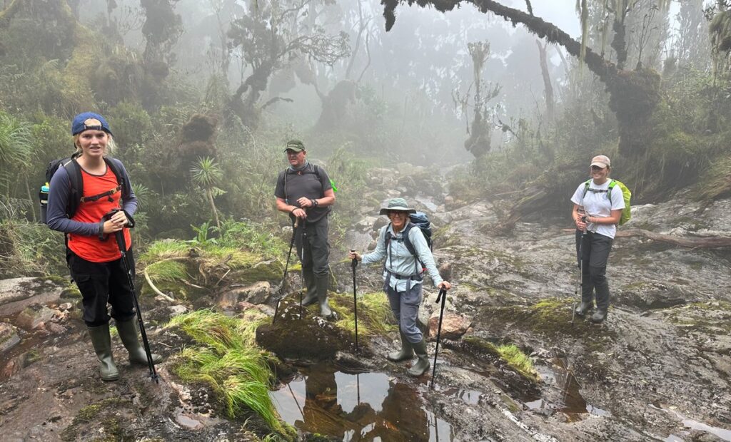
The first section descends briefly before beginning a sustained climb through thick Afro-montane rainforest. This ecosystem is immediately arresting: the canopy filters the equatorial light into shafts of green, the air is heavy with moisture and the scent of rotting leaves, and the trail is alive with sound. Keep your eyes on the canopy for the Rwenzori turaco, whose crimson-red wing patch flashes brilliantly when it takes flight. Blue monkeys crash through mid-level branches; three-horned chameleons grip mossy trunks with deliberate slowness. You cross a suspension bridge over the Nyamwamba River, and the trail begins to earn its reputation for being rugged.

Roughly midway, you encounter Enock’s Falls, a broad, powerful cascade that tumbles from the escarpment above. It is a natural rest stop and your first taste of the Rwenzori’s extraordinary hydraulic energy; these mountains generate some of the highest rainfall in Africa, feeding the Nile itself from their glaciers. The final push to Sine Camp climbs steeply through forest that is becoming denser and more moss-laden with every meter of altitude gained. Sine Camp itself sits in a clearing at 2,596m, its wooden huts are perched above the treeline with the forest still close on all sides.
Meals: Packed lunch on trail. Three-course dinner and breakfast at camp. All food is prepared by your mountain cook.
Day 2: Sine Camp (2,596 m) → Mutinda Camp (3,582 m)
Distance: 6.1 km | Elevation Gain: +986 m | Hiking Time: 6–8 hours
Day 2 is a shorter distance but demands more from your legs: you gain nearly a vertical kilometer from Sine to Mutinda. The trail leaves the upper reaches of the montane forest and transitions into a bamboo forest that is dense, hollow-sounding, and deeply atmospheric. The bamboo gives way to giant heather (Erica arborea) draped in beards of lichen that hang from every branch, creating a twilight world that feels ancient and untouched.
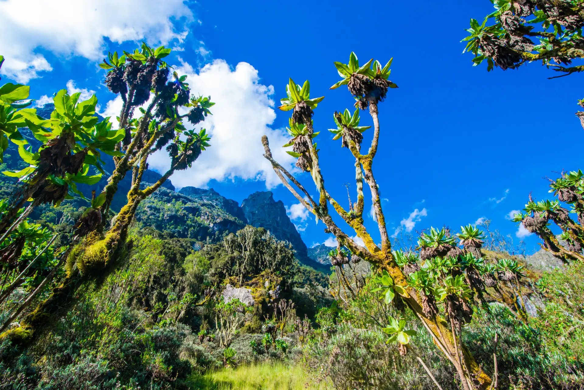
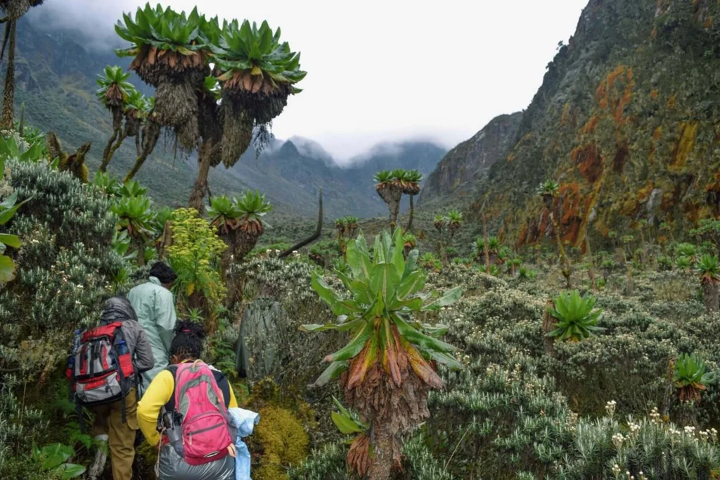
The terrain is consistently steep, and the trail surface alternates between packed earth, slippery roots, and the beginning of the mud and bog sections that characterize the Kilembe Trail at altitude. Rubber boots provided by Rwenzori Trekking Safaris come into their own today. The heather and moorland zone is the heart of the Rwenzori’s unique ecosystem: the giant lobelias (Lobelia wollastonii) begin to appear, their silvery-grey flower spires rising like frozen rockets above the ground cover. Dendrosenecio (giant groundsel) trees, which can live for over a hundred years, punctuate the ridge with their alien silhouettes.
An optional acclimatization detour climbs to Mutinda Lookout (3,975 m), a short, steep side trip that rewards with a panoramic view sweeping east over the Kasese plains, Lake George, and Queen Elizabeth National Park. The extra altitude exposure, combined with a descent to sleep at Mutinda Camp (3,582m), is a textbook acclimatization strategy. Mutinda Camp is set on an open ridge with wind shelter from a cluster of heathers; on clear evenings, the silhouettes of Mount Stanley’s glaciated flanks are visible to the northwest.
Meals: Hot breakfast at Sine. Packed lunch on trail. Dinner at Mutinda Camp.
Day 3: Mutinda Camp (3,582 m) → Bugata Camp (4,100 m)
Distance: 8.6 km | Elevation Gain: +518 m (with dips) | Hiking Time: 4–6 hours
Day 3 carries you deeper into the Rwenzori’s high alpine zone via the extraordinary Namusangi Valley. This is the day many trekkers cite as the most visually overwhelming of the entire trek: the valley is a corridor of botanical superlatives. Giant lobelias reach up to six metres in height, with their rosettes of succulent leaves spiraling skyward. Dendrosenecio trees, some estimated to be centuries old, punctuate the bogs and ridges with their prehistoric crowns. Everlasting flowers (Helichrysum), the Rwenzori’s answer to an alpine meadow, carpet the open ground in silver and gold.

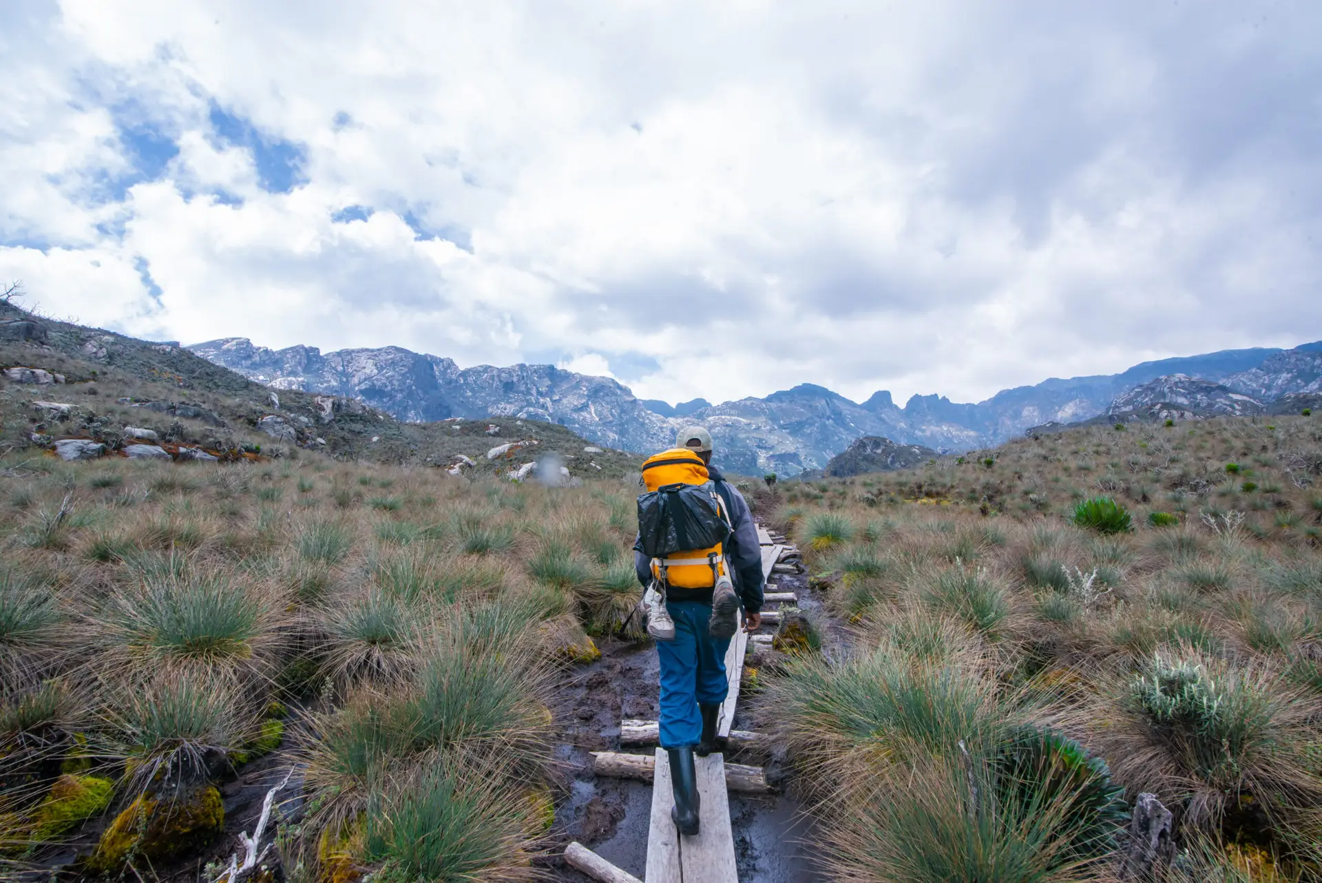
The trail crosses several waterfalls as it traverses the valley floor and climbs along its flanks. Permanent streams carry meltwater down from the glaciers above; in the dry season, the flow is reduced, but after rain the valley fills with the sound of rushing water. The bogs here are genuine: sections of the trail disappear into ankle-deep, occasionally knee-deep mud, and careful footwork is required on the wooden boardwalks (where they exist). Your rubber boots will be thoroughly tested.
As you climb toward Bugata Camp at 4,100m, the vegetation thins and the sky opens. The first glacier views appear above the ridgeline: thin white bands on rock that seem impossibly high. Bugata Camp sits on a natural platform with unobstructed views of the peaks ahead. At night, the temperature drops well below freezing; your sleeping bag and thermal layers are essential from this point forward.
Meals: Hot breakfast at Mutinda. Packed lunch on trail. Hot dinner at Bugata Camp.
Day 4: Bugata Camp (4,100 m) → Hunwick's Camp (3,974 m)
Distance: 8.3 km | Elevation Gain/Loss: +350 m / -476 m (via Bamwanjara Pass) | Hiking Time: 6–8 hours
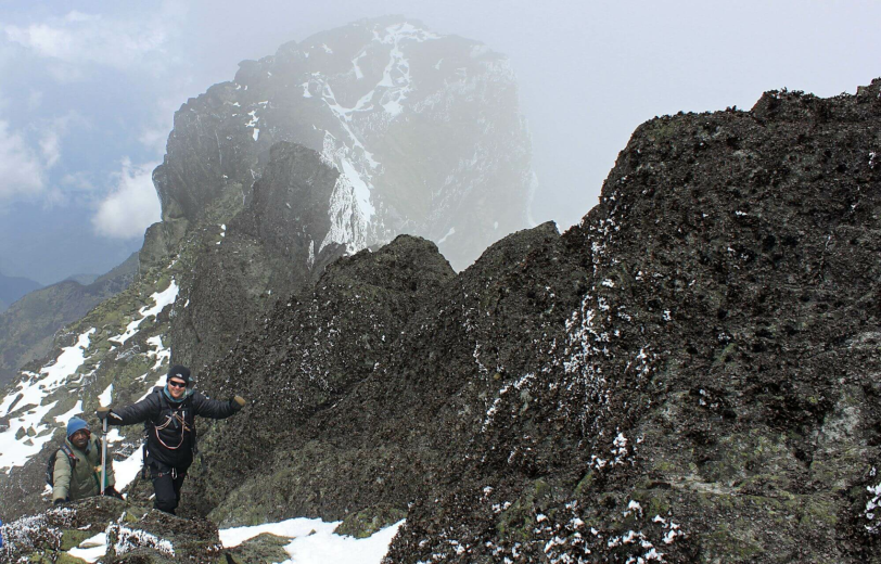
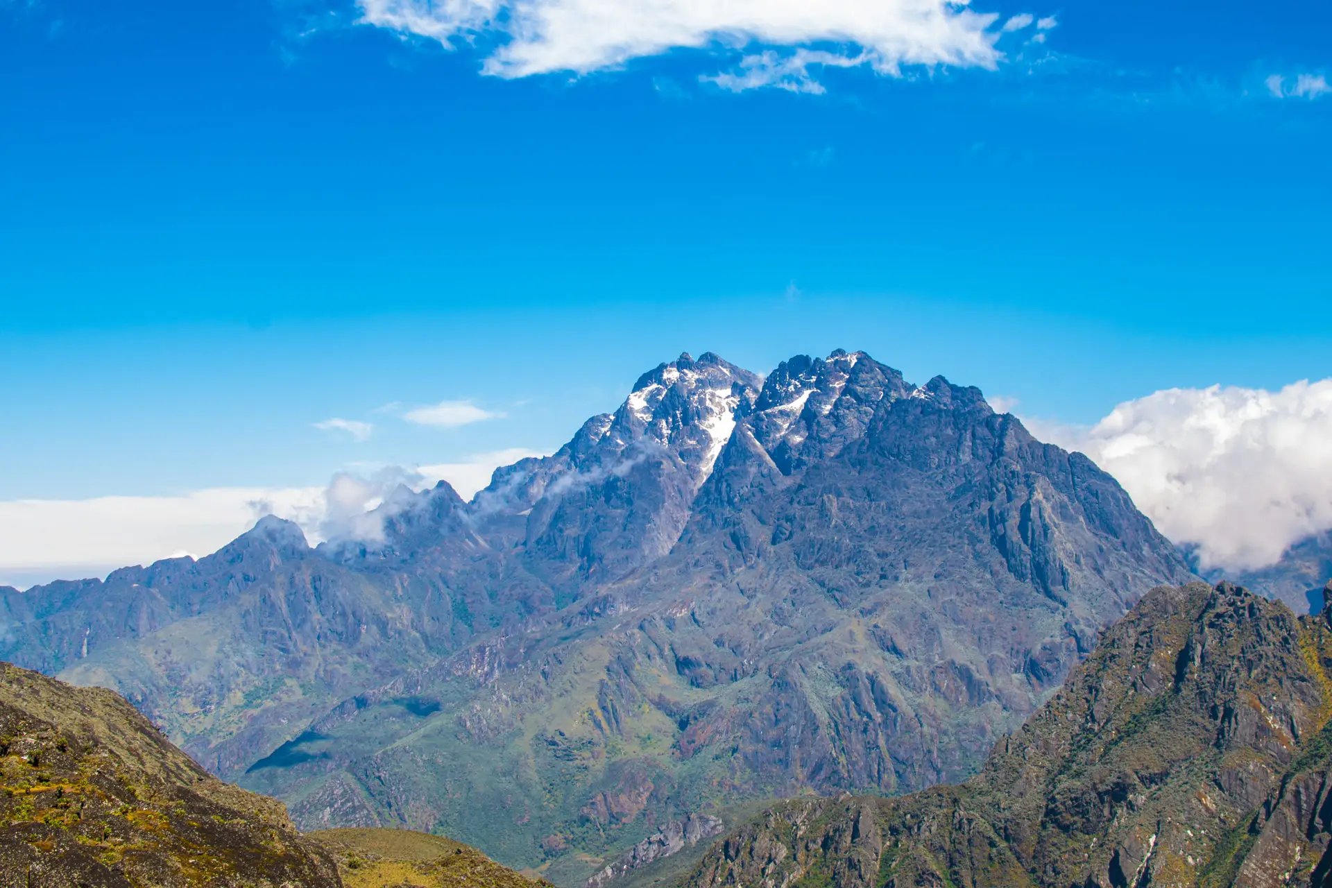
Day 4 is the mountain’s spectacular reveal. The route climbs to Bamwanjara Pass at 4,450 m, the highest point so far on the trek, before dropping to Hunwick’s Camp. From Bamwanjara Pass on a clear morning, the three greatest peaks of the Rwenzori are simultaneously visible: Mount Stanley with Margherita’s glaciated summit, Mount Baker’s ice-draped Edward Peak, and the flanks of Mount Speke. It is the kind of alpine panorama that justifies the entire expedition.

The ascent to the pass exposes hikers and requires them to take careful footing on rocky terrain. The Afroalpine zone here consists of sparse small rosette plants, cushion vegetation, and patches of bare rock that are colonized by lichens. The air at 4,450m is noticeably thin, and the pace slows accordingly. Your guide will monitor everyone in the group for signs of altitude sickness; if anyone shows moderate or severe symptoms, the protocol is to descend immediately. Take it slowly, drink consistently, and do not push beyond your comfortable pace.
The descent from Bamwanjara Pass to Hunwick’s Camp at 3,974 m goes through a landscape of glacially scoured rock and remnant moraines, which are geological evidence of the much larger glaciers that covered these mountains thousands of years ago. Hunwick’s Camp is a critical base for the next two days: it sits in a sheltered position and serves as the departure point for both the Mount Baker summit attempt (Day 5) and the approach to Margherita Camp (Day 6). Spend the afternoon rehydrating, eating well, and reviewing the summit-day briefing with your guide.
Meals: Hot breakfast at Bugata. Packed lunch at Bamwanjara Pass or on trail. Hot dinner at Hunwick’s Camp.
Day 5: Summit Day: Mount Baker, Edward Peak (4,842 m) | Return to Hunwick's Camp (3,974 m)
Round Trip: ~8–10 km | Elevation Gain: +868 m | Summit Time: 6–9 hours total
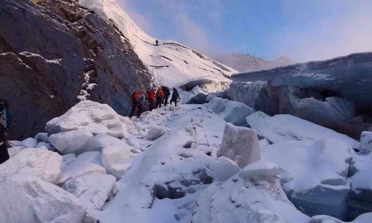
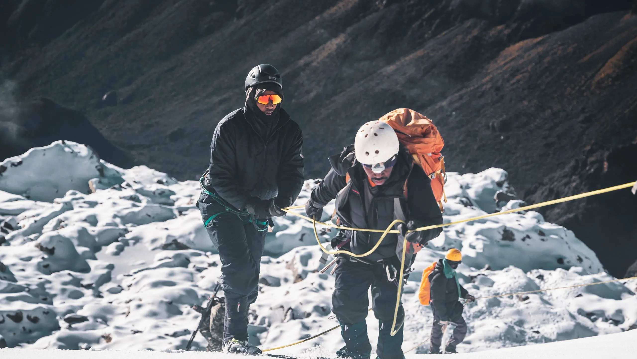
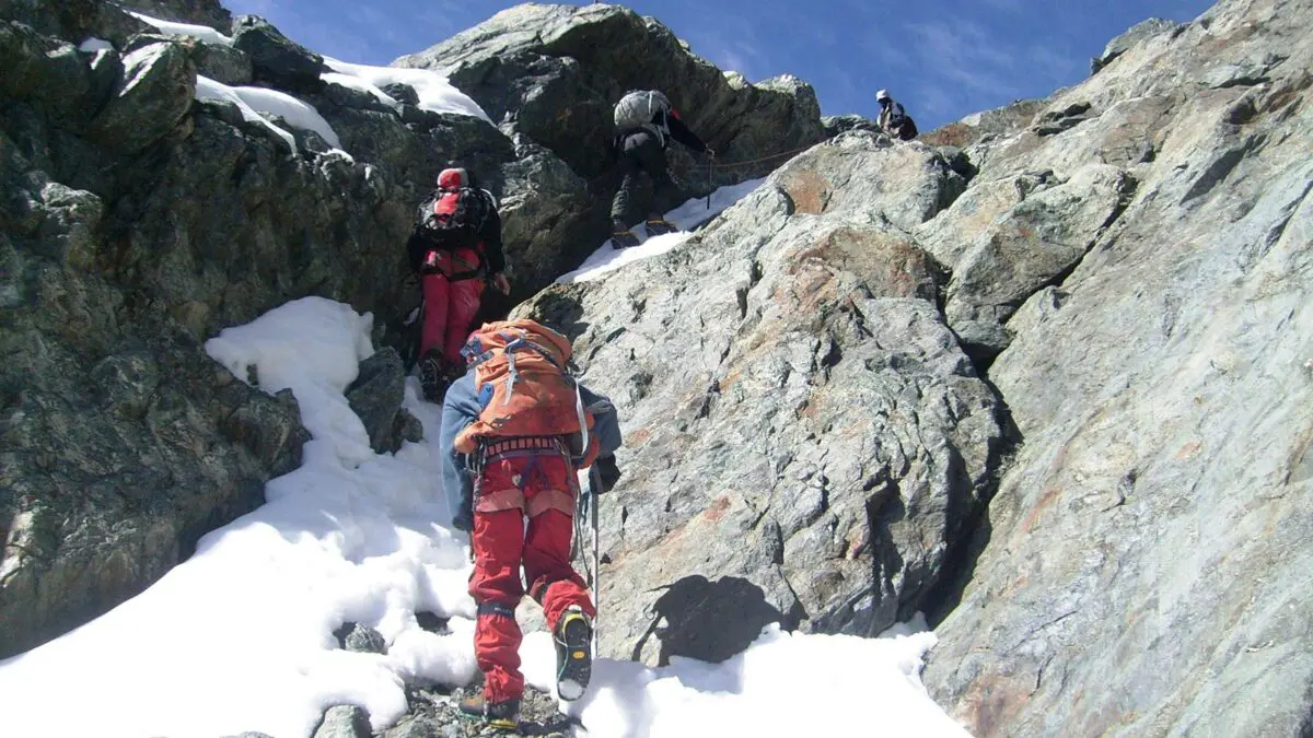
The alarm sounds early at Hunwick’s Camp, typically at 4:00 or 5:00 am, and you begin your first summit attempt in the darkness. Mount Baker (4,842 m) is the Rwenzori’s third-highest massif, and its highest point, Edward Peak, requires a sustained climb over rocky terrain and, depending on conditions, a short section of glacial travel. Crampons, an ice axe, and a harness are provided by Rwenzori Trekking Safaris; your guide will brief you on their use before you set off.
The pre-dawn climb is one of the trek’s defining experiences. Headlamps probe the darkness above; the only sounds are boots on rock, the wind, and steady breathing. As dawn breaks, the eastern sky turns amber and pink, and the silhouette of Mount Stanley’s twin peaks appears to your left. The Rwenzori’s famous mists often part at first light, and the moments of clarity can be extraordinary; the glaciers catch the first rays with a cold blue fire.
The descent back to Hunwick’s Camp typically takes 2–3 hours. Spend the afternoon recovering, eating, and hydrating aggressively. Day 5’s summit is preparation for Day 7’s greater challenge.
Meals: A hot breakfast before 5 a.m. departure. Packed summit lunch. Hot dinner at Hunwick’s Camp on return.
Technical gear: Crampons, ice axes, harnesses, helmets, and fixed ropes at key sections are all provided.
Day 6: Hunwick's Camp (3,974 m) → Margherita Camp (4,485 m)
Distance: ~5.1 km | Elevation Gain: +511 m | Hiking Time: 4–6 hours
Day 6 is a transitional day, but do not underestimate it. The route from Hunwick’s Camp to Margherita Camp at 4,485 m passes via Lake Kitandara, one of the most beautiful high-alpine lakes in East Africa. The lake sits in a glacially carved hollow at around 4,023 m, its dark water perfectly still on calm mornings and reflecting the rocky walls above. It is a natural resting point and one of the most photographed spots on the Kilembe Trail.
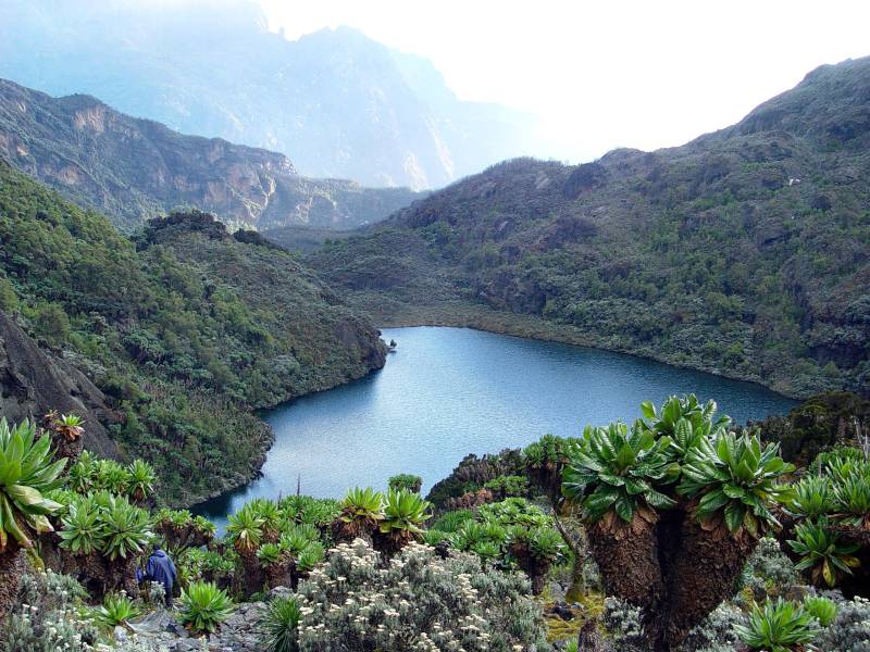
From Lake Kitandara, the trail climbs steeply via Scott Elliott’s Pass, named for the 1895 explorer who first traced these valleys. The pass sits at around 4,372 m and marks the transition from the Kilembe side of the mountains to the approach zone for Mount Stanley. The terrain above Scott Elliott’s Pass is increasingly rocky and exposed, with thin vegetation and the sound of wind dominant. Margherita Camp appears as a cluster of small huts on a narrow shelf below the glacier’s terminal moraine.
Margherita Camp (4,485 m) is the highest permanent camp on the Kilembe Trail. At this elevation, every movement requires a deliberate pace. The headaches and breathlessness that accompany altitude are normal here; however, severe symptoms such as confusion, inability to walk a straight line, and coughing up blood are not. Your guide will decide to descend if necessary. Tonight’s priority is hydration, a nourishing meal, and sleep. Your summit alarm is set for 4:00 am.
Meals: Hot breakfast at Hunwick’s. Packed lunch. Early hot dinner at Margherita Camp.
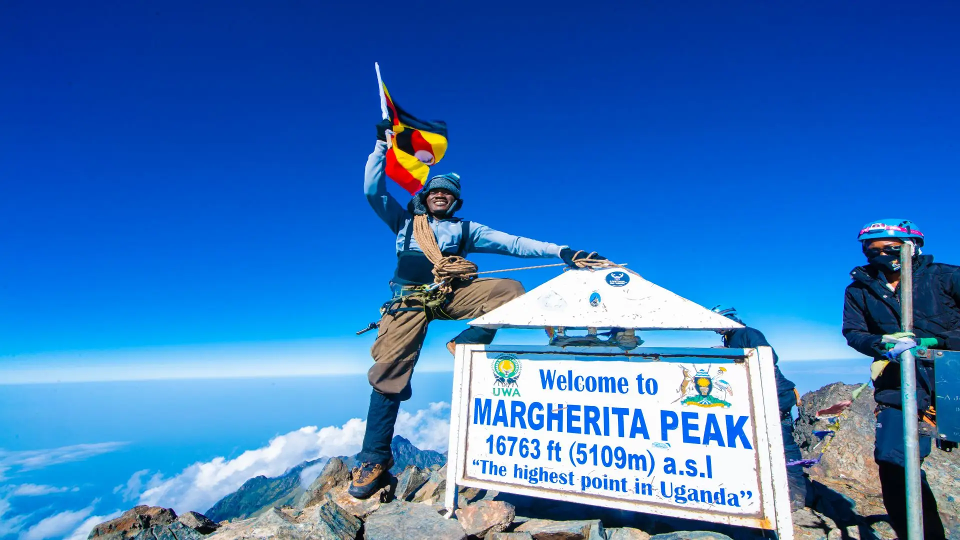
Day 7: SUMMIT DAY: Margherita Peak (5,109 m) | Descend to Hunwick's Camp (3,974 m)
Distance: ~9 km round trip | Elevation Gain: +624 m | Total Time: 9–12 hours
This is the day the entire expedition has been building toward. The alarm sounds at 4:00 am, sometimes earlier, and you leave Margherita Camp in full darkness. Your guide leads the rope team up the initial rocky section by headlamp; the temperature at the start will be between -5°C and -10°C, possibly lower with wind chill. Every layer you have comes out: base layer, mid-layer fleece, hardshell jacket and trousers, insulated gloves, and balaclava.
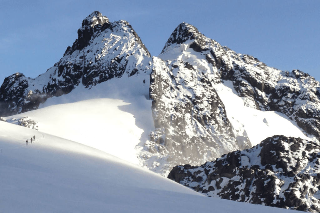
As you ascend the glacier, the sky brightens behind you. The sunrise at these altitudes over the Rwenzori’s eastern flanks, with the Rift Valley floor far below, is the kind of moment that stays with you for a long time. Trekkers who reach the summit of Margherita Peak at 5,109m stand at Africa’s third-highest point, behind only Kilimanjaro (5,895 m) in Tanzania and Mount Kenya (5,199 m). On a clear summit morning, you can see the peaks of the DRC’s Virunga chain to the south and the expanse of western Uganda’s Rift Valley to the east.
Meals: Very early hot breakfast (3:30–3:45 am). Packed summit rations (energy bars, thermos drinks). Hot dinner at Hunwick’s on return.
Technical gear: Crampons, ice axes, harnesses, helmets, and ropes are all provided. Wear all thermal and waterproof layers.
Day 8: Hunwick's Camp (3,974 m) → Kiharo Camp (3,430 m)
Distance: 15.8 km | Elevation Change: -544 m (with ridge sections) | Hiking Time: 9–10 hours
Post-summit euphoria carries you into Day 8, which is one of the trek’s longest days in terms of distance. The route descends from Hunwick’s Camp, crosses a section of glacially carved high plateau, and traverses Oliver’s Pass. From Oliver’s Pass, the massif of Weismann Peak on Mount Luigi di Savoia (4,627 m) is visible to the south; a faint trail leads toward it for those on the 10-Day 4-Peaks itinerary, but your route descends into the Nyamwamba Valley system.
The terrain on Day 8 alternates between rocky ridge walking, ancient glacial valleys, and the characteristic Rwenzori bog crossings. Despite being a decent day, the route is far from easy; crossing an alpine bog with tired legs after two summit days requires focus and patience. Decades of wind have often twisted the giant groundsel trees at this elevation into extraordinary sculptural forms; the photography opportunities are exceptional.
Kiharo Camp, at 3,430 m, sits in a broader valley than the previous camps and shelters itself from the dominant winds. After the exposed high camps of the past three nights, the relative warmth and shelter feel luxurious. Your mountain cook will have prepared a hot meal; the evening rituals of removing boots, tending to any blisters, and swapping summit stories in the hut carry a deep satisfaction that only comes from genuine effort.
Meals: Hot breakfast at Hunwick’s. Packed lunch on trail. Hot dinner at Kiharo Camp.
Day 9: Kiharo Camp (3,430 m) → Kilembe Base Camp | Transfer to Kasese
Distance: 16 km | Elevation Loss: -1,980 m | Hiking Time: 6–8 hours
The final day on the mountain is a long descent through the entire altitudinal sequence in reverse from moorland through heather, down through bamboo, and into the lower Afro-montane forest. The Nyamwamba Valley carries you home: it is one of the most beautiful descent corridors in the Rwenzori, with the river growing louder and the vegetation thickening with every passing hour. Duikers, small forest antelopes, dart across the trail in the lower forest sections; colobus monkeys appear in the upper canopy.
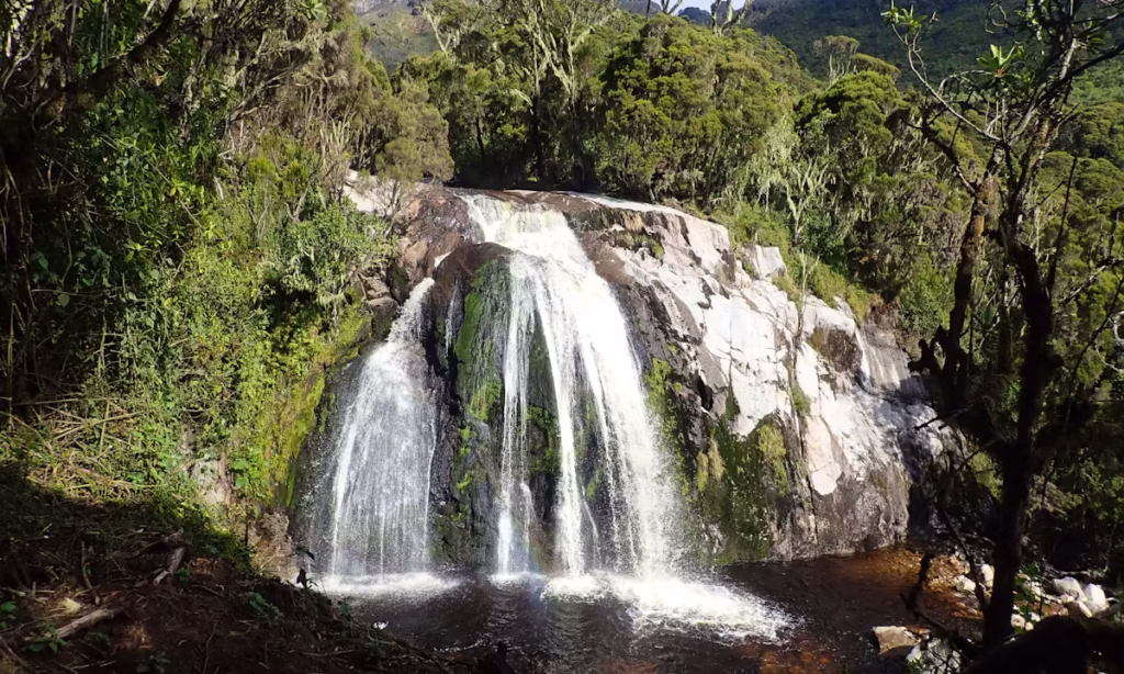
Waterfalls punctuate the descent, fed by the same hydrological system that makes the Nyamwamba River one of the Nile’s tributary contributors. As you drop below 2,000m, the air thickens noticeably; the warmth is almost shocking after nine nights of alpine cold. The Trekkers Hostel in Kilembe comes into view after the final forest section, a moment greeted by every group with a particular quality of silence.
Back at base, you tip your porters, return technical equipment, and shower. Transfer vehicles return you to Kasese town, roughly 10 minutes from Kilembe, where pre-booked accommodations are available. Many trekkers choose a celebratory dinner in Kasese before the drive back toward Kampala, Entebbe, or their next Uganda destination.
Meals: Hot breakfast at Kiharo. Packed lunch on trail or at base. Dinner in Kasese (own arrangement).
Day 10: Optional Recovery Day | Departure or Onward Travel
No hiking, required rest, cultural visit, or onward transfer.
Day 10 is built into the itinerary as a buffer and recovery day. Many trekkers use it to rest in Kasese, visit the local Bakonzo community markets, or make the short drive to Queen Elizabeth National Park for a boat safari on the Kazinga Channel. Fort Portal, a charming highland town with excellent accommodation, crater lakes, and proximity to Kibale Forest National Park (chimpanzee tracking), is another popular post-trek destination approximately 75km north of Kasese.
If you are connecting the Rwenzori trek with a gorilla trekking permit in Bwindi Impenetrable Forest, Day 10 begins the drive south. The combination of Rwenzori climbing and gorilla trekking is one of Uganda’s signature adventure pairings
Elevation Profile: The Arc of the 10-Day Trek
The 10-Day Rwenzori Trek follows a classic alpine profile: sustained ascent, high-altitude plateau, dual summit attempts, and long descent. Understanding the elevation arc helps you anticipate where the challenging days fall.
Elevation Arc OverviewDay 1: 1,450 m → 2,596 m (+1,146 m) Steady forest climb to Sine Camp Day 2: 2,596 m → 3,582 m (+986 m) Steep heather zone climb to Mutinda Camp Day 3: 3,582 m → 4,100 m (+518 m) Alpine traverse to Bugata Camp Day 4: 4,100 m → 4,450 m → 3,974 m (Pass +350 m, descent -476 m) Bamwanjara Pass to Hunwick’s Day 5: 3,974m → 4,842m → 3,974m (+868 m/-868 m) Mount Baker summit day Day 6: 3,974m → 4,023m → 4,485m (+511 m) Via Lake Kitandara to Margherita Camp Day 7: 4,485 m → 5,109 m → 3,974 m (+624 m/-1,135 m) Margherita Peak summit; descend to Hunwick’s Day 8: 3,974 m → 3,430 m (-544 m) Via Oliver’s Pass to Kiharo Camp Day 9: 3,430 m → 1,450 m (-1,980 m) Full descent via Nyamwamba Valley to base Total Cumulative Ascent: ~5,200 m over 9 hiking days |
Camps & Accommodation on the 10-Day Kilembe Trail Trek
All accommodation in the Rwenzori Mountains is in sturdy wooden mountain huts provided at designated campsites within Rwenzori Mountains National Park. There are no tents on this trek; huts provide protection from rain, wind, and the dramatic temperature swings of alpine-Afroalpine nights. Sleeping arrangements are typically communal bunk beds with mattresses; you bring (or hire) a sleeping bag. Facilities are basic but functional: pit latrines, water sources for filtering, and a cooking area. Your mountain cook prepares all meals using ported-in supplies.
Sine Camp, 2,596 m
The first mountain camp on the Kilembe Trail, Sine Camp sits at the upper edge of Afro-montane forest. The huts are well-maintained wooden structures with bunk beds. The sound of the forest birds and insects and the occasional crash of a monkey troop continues through the night. Water is available from a nearby stream (filter before drinking). This camp is your entry into the Rwenzori’s world.
Mutinda Camp, 3,582 m
Mutinda Camp, located in the heather and moorland zone, offers open views toward Kasese and the eastern plains, making it the first place where you truly feel the altitude. Temperatures at night routinely drop to 2–5°C. The surrounding vegetation is moorland, open, wind-sculpted, and deeply atmospheric. You should take the optional side trip to Mutinda Lookout (3,975 m) from this camp before the main climb.
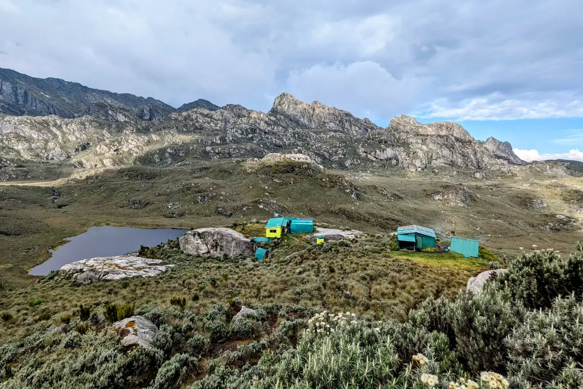
Bugata Camp, 4,100 m
Bugata Camp at 4,100m is the gateway to the high alpine world. The camp is set on a plateau with the first unobstructed views of the glacier-bearing peaks. Temperatures here drop below freezing at night. Sleep will come less easily at this altitude for some trekkers; such discomfort is normal. The main hut is solid; your cook will have hot drinks and food waiting on arrival.
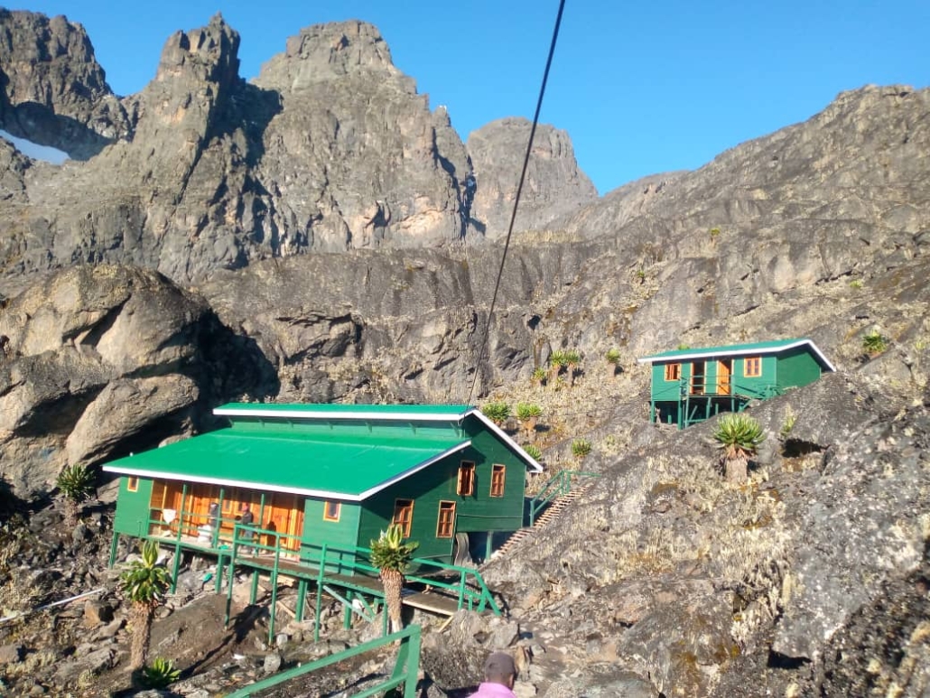
Hunwick’s Camp, 3,974 m
Hunwick’s Camp is the operational hub of the upper mountain on this itinerary, used on three separate nights (Days 4, 5 return, and 7 return). It sits in a sheltered position below the main ridge system, with relatively easy access to both the Mount Baker approach and the route toward Lake Kitandara and Margherita Camp. The camp’s strategic location as a central high camp makes it the most lived-in of all your stops, allowing you to learn its character well.
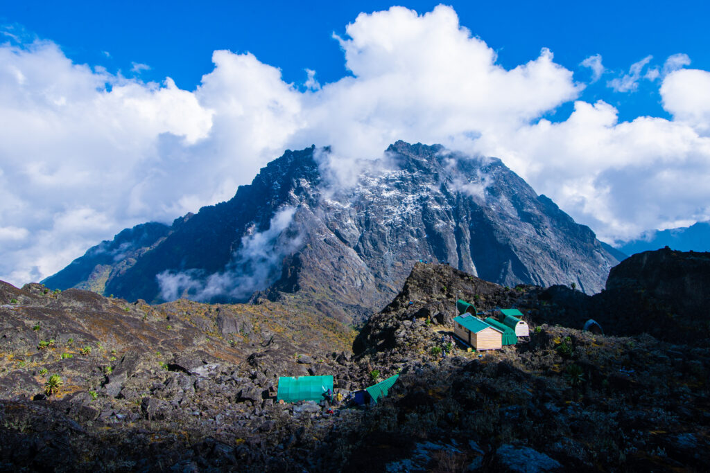
Margherita Camp, 4,485 m
The highest camp on the Kilembe Trail, Margherita Camp, perches on a narrow shelf at the base of the Stanley Glacier approach. This is a spartan, serious camp. The facilities are minimal; the cold is real. But the location is singular: you are sleeping on the shoulder of Africa’s third-highest mountain, with the glacier above you and the entire eastern Rwenzori below. Hardly any people sleep this high in Uganda. Make the most of the quiet.
Kiharo Camp 3,430m
Kiharo Camp is the first descent camp after the summit days, sitting in a broader, more sheltered valley than the high camps. The relative warmth (temperatures rarely drop below -2°C) and the sense of descent feel almost celebratory. This is your last mountain camp; enjoy the evening meal and the satisfaction of what you have accomplished.
Flora & Wildlife: What to Expect on the Kilembe Trail
The Rwenzori Mountains National Park contains one of the most distinctive botanical ecosystems on earth, a series of vegetation zones stacked by altitude, each with its own characteristic flora that exists nowhere else in the world at this density and scale. The Kilembe Trail passes through all five major zones.

Afro-Montane Forest (1,450 m–2,600 m)
The lower forest zone is teeming with life: Rwenzori turacos (with their stunning red wing patches), Cameroon sunbirds, African goshawks, and Rwenzori batis. Blue monkeys and red-tailed monkeys are common in the mid-canopy. The forest floor hosts three-horned chameleons, which are endemic to this region. Orchids and tree ferns dominate the understory. This zone receives the heaviest rainfall on the mountain.
Bamboo Zone (2,600 m–3,200 m)
As the trail climbs through bamboo (Arundinaria alpina), the forest becomes darker and the bird life shifts. Buffalo have historically used bamboo zones for feeding; while sightings in the national park are less common now, evidence of their passage, broken culms and tracks in mud, is frequently seen. The bamboo thins as altitude increases, giving way to giant heathers.
Heather & Moorland Zone (3,200 m–4,000 m)
Giant tree heathers (Erica arborea) draped in old man’s beard lichen (Usnea) define this zone. The first giant lobelias appear, Lobelia wollastonii, which can reach six metres and flowers only once in its 50–100- year lifespan before dying. Dendrosenecio (giant groundsel) trees stand like prehistoric sentinels. The three-spotted leopard (rare but present in the park) and the duiker are the main mammals of this zone.
Afro-alpine Zone (4,000 m–4,800 m)
Above 4,000m, the vegetation becomes spectacularly alien: massive rosette plants, everlasting flowers, cushion plants, and the highest-altitude dendrosenecio species. This zone is the visual heart of the Rwenzori’s uniqueness, a botanical realm that has evolved in isolation over millions of years. Hyraxes (small, rock-dwelling mammals distantly related to elephants) are commonly spotted on rocky outcrops at this altitude.
Nival Zone (4,800 m–5,109 m)
Above the snowline, life retreats to lichen on rock and the occasional wind-blown insect. The glacier itself supports specialized algae in certain conditions. This region is the realm of geology, not biology: ancient Precambrian crystalline rocks, ice, and sky.
Physical Difficulty & Fitness Requirements
Difficulty Rating: Challenging to Very ChallengingThis rating reflects sustained daily elevation gain, technical glacier sections on summit days, technical terrain on passes, and the cumulative physical demand of 9 consecutive days of hiking at altitude. |
The 10-Day Rwenzori Trek via the Kilembe Trail is not a beginner hike. It is a serious mountain expedition that involves two days of technical glacier crossing, multiple high-altitude passes, long daily distances across challenging terrain, sustained exposure to cold and wet conditions, and nine consecutive days of physical effort. That said, it is absolutely achievable for fit, motivated trekkers without formal mountaineering experience because your guides provide all technical instruction and equipment on summit days.
Minimum Fitness Level
You should be able to hike 15–20km per day for multiple consecutive days with a daypack. You should be comfortable hiking for 7–10 hours. You should have completed multi-day hikes at altitude (anywhere from 2,000 m+) previously. If you have not trekked at altitude before, we strongly recommend completing our acclimatization guide and discussing your fitness history with us before booking.
Recommended Training
- Cardiovascular base: 60–90 minutes of sustained cardio (running, cycling, swimming) at least 4 days/week for 3 months before the trek
- Hiking-specific training: Weekend hikes of 15–25km with a 5–8kg daypack, on hilly terrain, for 8–12 weeks before departure
- Leg strength: Squats, lunges, step-ups, and stair climbing build the specific muscle groups that the Rwenzori’s steep trails demand
- Altitude preparation: If possible, hike at 3,000–4,000m altitude (Alps, Kilimanjaro, Atlas Mountains) in the 6 months before the trek
- Core stability: Strong core muscles reduce fatigue and injury risk on uneven, boggy terrain
Altitude Acclimatization
This itinerary incorporates acclimatization strategies throughout: the gradual 10-day ascent profile, the optional acclimatization excursion to Mutinda Lookout on Day 2, the ‘climb high, sleep low’ pattern at Bamwanjara Pass on Day 4, and the two-night stay at Hunwick’s Camp before ascending to Margherita. Do not take altitude medication (like Diamox) without discussing it with a doctor first and read our full acclimatization guide before departure.
Best Time to Do the 10-Day Rwenzori Trek
The Rwenzori Mountains sit on the equator and receive rainfall year-round; they are among the wettest mountains in the world. However, two distinct dry windows offer significantly better trekking conditions:
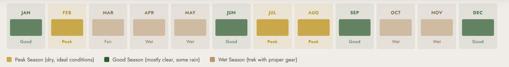
Primary Dry Season: December – March
December through March is generally the most stable weather period on the Rwenzori. Rainfall is reduced, trails are drier, cloud cover often clears on summit days, and views from the high camps can be exceptional. This is the single best period to attempt Margherita Peak. January and February offer particularly excellent summit weather. Temperatures remain cold at altitude (night lows of -5°C to -12°C at Margherita Camp), but daytime conditions can be clear and bright.
Secondary Dry Season: June – August
June, July, and August bring another weather window, though historically wetter than December–March. This is still a viable time to trek, and many trekkers choose it to align with Northern Hemisphere summer holidays. Summit days in June–August are less predictably clear but are entirely achievable. The Kilembe Trail’s lower sections can be very muddy in June; rubber boots are mandatory.
Shoulder & Wet Seasons: April–May & September–November
The Rwenzori’s heavy rains arrive in April, May, October, and November. The mountain is still open for trekking, and some trekkers relish the atmosphere: the waterfalls are spectacular, the vegetation is vivid green, and the mountain is quiet. However, trails are significantly muddier, clouds obscure summit views on most days, and the technical glacier sections require more caution. With the right gear and realistic expectations, these months are perfectly safe.
What’s Included & What’s Not Included
Included in the Package
- All Uganda Wildlife Authority (UWA) park entry fees and trail permits
- Professional certified lead English-speaking mountain guide(s), first-aid trained
- Experienced Bakonzo porters (1 porter per trekker, 20kg limit per porter)
- All meals on the mountain: breakfast, packed lunch, and three-course dinner daily
- Accommodation in designated wooden mountain huts at all camps
- Technical summit equipment: crampons, ice axes, harnesses, helmets, fixed ropes
- Free use of rubber boots (essential for the Kilembe Trail’s bog sections; all sizes available)
- Drinking water (from mountain sources; provided for boiling/filtering)
- Emergency oxygen supply carried by guides
- First-aid kit and emergency protocols
- 10% of trek proceeds directed to supporting local Bakonzo community initiatives
Not Included
- International flights and Uganda visa fees
- Personal travel insurance and medical evacuation (medivac) insurance mandatory; see our insurance guide
- Tips and gratuities for guides and porters (see tipping guide below)
- Accommodation in Kasese before and after the trek
- Transfers to/from Kilembe trailhead from Kasese or Kampala (available as add-on)
- Personal trekking gear: sleeping bag, thermal layers, waterproofs, trekking poles (rental available in Kasese)
- Personal snacks, energy bars, and electrolyte drinks
- Alcoholic beverages
- Travel to/from Uganda
Full Packing & Gear List for the 10-Day Rwenzori Trek.
The Kilembe Trail demands robust, waterproof, and thermally adequate kit. The mountain is wet, profoundly wet, and the temperature range over the 10 days spans from 30°C at Kasese to -12°C on summit night. Packing for both extremes is non-negotiable.
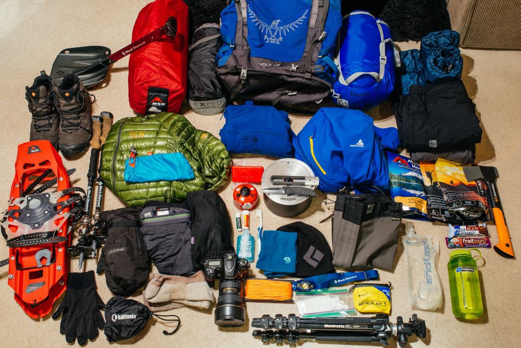
Footwear (Critical)
- Rubber boots (provided by RTS essential for bog crossings; all sizes available)
- Lightweight trail shoes or sandals for camp use
- Thick wool or merino hiking socks: minimum 3 pairs; 5 preferred
- Neoprene socks for extra warmth in rubber boots on summit days
Clothing Layers
- Base layer (thermal): 2 tops, 1 bottom merino wool or synthetic
- Mid layer: fleece jacket or down-insulated vest
- Summit insulation: down jacket (minimum 600-fill; 800-fill recommended)
- Hardshell jacket: waterproof, breathable (Gore-Tex or equivalent) non-negotiable.
- Waterproof trousers: full zip sides for fitting over rubber boots
- Hiking trousers: 2 pairs (1 waterproof-treated)
- T-shirts: 2–3 lightweight moisture-wicking
- Balaclava and warm hat: both, not one or the other
- Gloves: thin liner gloves AND waterproof insulated mitts for summit day
- Gaiters (optional but useful in heavy bog conditions)
Technical Summit Gear: All Provided by RTS
- Crampons (fitted to your rubber boots on summit days)
- Ice axe
- Climbing harness
- Helmet
- Rope (group equipment, managed by guides)
Pack & Carry
- Daypack: 25–35 litres for carrying daily items (porters carry main luggage)
- Dry bags or bin liners: to keep sleeping bag and electronics dry inside the main bag
- Trekking poles: collapsible, with rubber and spike tips
Sleeping
- Sleeping bag: rated to at least -10°C (0°C is not sufficient for Margherita Camp)
- Sleeping bag liner: adds warmth and extends sleeping bag rating
Health & Personal
- Personal first-aid kit: blister plasters, ibuprofen, paracetamol, rehydration sachets, antidiarrheal
- Diamox (acetazolamide): discuss with your doctor before the trek; bring if prescribed
- Sunscreen SPF 50+: UV radiation is extreme above 4,000m near the equator
- Lip balm with UV protection
- Insect repellent: for lower forest sections only
- Hand sanitiser: essential at camp; water for handwashing is limited
- Wet wipes: for washing at higher camps
- Prescription medications: full supply plus extras
Electronics & Extras
- Headlamp: with fresh batteries plus spares, critically important for 4am summit starts
- Power bank: large capacity (the mountain has no electricity)
- Camera: waterproof or in a waterproof case; condensation is a serious issue
- Reusable water bottles: minimum 2 litres capacity total; hydration bladder optional
- Water purification: tablets or a SteriPen for treating mountain water sources
- Trekking food: energy bars, gels, nuts, chocolate 10 days of personal snacks
- Cash (Ugandan shillings): for tips, any extras in Kasese
- Passport and park permit documentation (provided by RTS)
Rwenzori Permits, Park Fees & Cost Breakdown
All trekking in the Rwenzori Mountains National Park is regulated by the Uganda Wildlife Authority (UWA), which manages both the park infrastructure and the Kilembe Trail through a concession with Rwenzori Trekking Services (RTS). All fees and permits are handled by Rwenzori Trekking Safaris as part of your package; you pay a single price, and we manage all park logistics.
The following guide outlines what the park fee structure includes (2025/26 rates; subject to UWA revisions):
- UWA park entry fee: charged per day inside the park
- Trail fee/concession: allocated to trail maintenance and camp facilities
- Ranger fee: mandatory guide fees paid to UWA-registered guide service
- Technical equipment levy: for glacier and summit equipment
- Mountain hut accommodation fees: per night per person
The mountain sets guide and porter rates and factors them into your package price. Tipping is separate and entirely voluntary, though warmly appreciated. See our porter tipping guide for recommended amounts and cultural context.
Getting to the Rwenzori Mountains: Trailhead Logistics
From Kampala (387 km, 5–6 hours by road)
The most common route is by private vehicle or coach from Kampala. The journey takes 5–6 hours on the sealed and generally good-condition Fort Portal–Kasese highway. Rwenzori Trekking Safaris can arrange private 4WD transfers from Kampala at an additional cost. Budget bus services (with stops) also operate on this route, though they take 8–10 hours.
From Entebbe Airport (430 km, 6–7 hours by road)
Arriving internationally at Entebbe International Airport, the drive to Kasese is approximately 6–7 hours via Kampala. We recommend booking a night in Kampala or Entebbe on arrival before making the full day’s drive west. Our Kasese guide covers pre-trek accommodation options.
From Kasese Town to Kilembe Trailhead (~12 km, ~20 minutes)
The Kilembe trailhead (Trekkers Hostel) is 12km from Kasese town center, a 15–20 minute drive on a tarmac road. Boda-bodas (motorcycle taxis), local minibuses, and private vehicles all serve this route. Rwenzori Trekking Safaris provides trailhead transfers as an add-on service.
By Air: Kasese Airport
Kasese has a small domestic airport with occasional charter services. Commercial domestic flights remain limited; check with Ugandan carriers (Aero Uganda, BAA Uganda) for current schedules. Flying to Fort Portal and driving onward to Kasese (75km, ~1.5 hours) is an alternative.
Book Your Slot
Respond within Minutes
From
$1,400
per person
- Duration 7 Days / 6 Nights
- Group Size 1–12 people
- Start Point Nyakalengija
- Departures Year-round
- Summits Margherita Peak
No booking fee. Free cancellation up to 30 days before departure. We respond within Minutes.
Our Popular Rwenzori Treks
Magheritah Peak (8 Days Kilembe Trail)
$1705 Per Person
Mutinda LookOut (4 Days)
$645 Per Person
Short Magherita Hike (5 Days Central Circuit)
$1200 Per Person
Rwenzori Hike (7 Days Central Circuit)
$1400 Per Person
Frequently Asked Questions: 10-Day Rwenzori Trek (Mount Stanley & Mount Baker)
How difficult is the 10-Day Rwenzori Trek via the Kilembe Trail?
The 10-Day Rwenzori Trek via the Kilembe Trail is rated as challenging to very challenging. The trek lasts 9 days, with daily hikes of 8–16km on rough, often muddy ground; a total elevation gain of about 5,200m; two summit attempts on technical glaciated peaks (Mount Baker at 4,842m and Margherita Peak at 5,109m); high-altitude exposure for most of the trek; and cold, wet conditions throughout. That said, it is achievable for fit, determined trekkers without formal mountaineering experience. The key requirements are excellent cardiovascular fitness, strong legs, experience with multi-day hiking, and the ability to follow your guide’s instructions precisely on the glacier. Our guides manage all technical sections and provide equipment and instruction.
Do I need mountaineering experience to summit Margherita Peak?
You do not need formal mountaineering training or experience to summit Margherita Peak via the Kilembe Trail. The technical glacier crossing on summit day is within the capability of a fit, motivated trekker who follows their guide’s instructions carefully. Rwenzori Trekking Safaris provides all technical equipment: crampons, ice axe, harness, helmet, ropes, and your certified guide will brief you on the correct use of each item at Margherita Camp the evening before your summit attempt. However, a genuine fear of heights or exposure to steep terrain would be a limiting factor; be honest with yourself and with us during the booking process.
What is the summit success rate for Margherita Peak on the 10-Day Kilembe Trek?
The 10-Day itinerary’s extended acclimatization profile gives it one of the highest success rates of any Rwenzori summit program. The gradual 4-day ascent to the high camps, combined with the Day 4 Bamwanjara Pass acclimatization push and the two-night stay at Hunwick’s Camp before ascending to Margherita Camp, means that the vast majority of physically prepared trekkers who reach Margherita Camp go on to summit. Weather on summit day is the primary limiting factor. Our guides monitor all trekkers continuously for altitude sickness symptoms and will make the safety call to descend if required.
What are the biggest differences between the Kilembe Trail and the Central Circuit?
The Kilembe Trail and the Central Circuit are the two main routes to Margherita Peak, and they offer meaningfully different experiences. The Central Circuit (from Nyakalengija, 1,646 m) is the classic route, traditionally more trodden, with a well-established camp system and a generally circular loop. The Kilembe Trail (from Kilembe, 1,450 m) is newer (launched in 2011), lower-starting, and considered more challenging in its lower sections due to steeper terrain and more pronounced bog crossings. The Kilembe Trail is generally less crowded and provides access to the southern flanks of the Rwenzori massif, including better positioning for Mount Baker summits. The 10-Day Kilembe itinerary is one of the most complete ways to experience the mountains.
What temperature should I expect on Margherita Camp and summit day?
Margherita Camp (4,485 m) regularly sees overnight temperatures between -5°C and -12°C. Wind chill can push the perceived temperature significantly lower, particularly on summit mornings when you depart at 4:00am. During the summit climb on the glacier, temperatures typically range from -8°C to -15°C with wind. You must have a sleeping bag rated to at least -10°C, a high-quality insulated jacket, waterproof hardshell layers, insulated gloves, a balaclava, and thermal base layers. This is not the place to economize on kit.
Is the Rwenzori safe to trek?
Yes, the Rwenzori is safe to trek with a reputable, fully equipped operator such as Rwenzori Trekking Safaris. The Uganda Wildlife Authority and Rwenzori Trekking Services certify all our guides, train them in wilderness first aid, and provide them with emergency oxygen. The biggest safety risks on the mountain are altitude sickness, hypothermia, and falls on wet terrain, all of which are managed through careful pace-setting, continuous monitoring, and the provision of proper gear. The park has a good emergency evacuation protocol, and our guides have led hundreds of summit expeditions.
How many porters will I have, and what do they carry?
On this itinerary, each trekker is assigned one dedicated porter. Each porter carries a maximum of 20 kg of equipment: your main bag, plus any shared group equipment and food. You carry your daypack (typically 5–8kg, containing water, snacks, rain gear, a warm layer, a camera, and personal essentials). Your porters are Bakonzo community members, for whom mountain work provides a critical livelihood. They are paid fair wages structured through the mountain operator and are entitled to proper equipment and accommodation. We encourage generous tipping as a direct contribution to local families.
Can older trekkers (50+) complete the 10-Day Rwenzori Trek?
Trekkers in their 50s, 60s, and even 70s have successfully completed Rwenzori expeditions, including summits of Margherita Peak. Age is not a disqualifying factor; fitness and cardiovascular health are what matter. The 10-Day itinerary’s generous pace and built-in acclimatization days make it more accessible to older trekkers than shorter, more compressed programs. We recommend a thorough pre-trek medical check with your doctor, including an ECG if you are over 60 and have not had one recently. Our guide for older trekkers on the Rwenzori addresses the specific considerations in detail.
What should I do about travel insurance for the 10-Day Rwenzori Trek?
All trekkers on our summit programs must have comprehensive travel insurance that specifically covers high-altitude mountaineering (above 5,000m) and helicopter medical evacuation. Standard travel insurance typically does not cover activities above 4,000–4,500m; you must check and upgrade your policy explicitly. The cost of a helicopter evacuation from the Rwenzori without insurance can exceed USD 5,000–10,000. Our travel insurance guide identifies which providers specifically cover Rwenzori summits and what documentation to carry on the mountain.
How do I compare the 10-Day Trek to the 8-Day Kilembe Trail or the 13-Day 6-Peaks Expedition?
The 8-Day Kilembe Trail itinerary targets Margherita Peak only, with a more compressed acclimatization schedule and no Mount Baker summit. It suits trekkers with strong prior altitude experience who want the Kilembe experience in a tighter time window. The 10-Day Trek adds Mount Baker as a second summit, providing significantly more value and a richer high-altitude experience for only two additional days. The 13-Day 6-Peaks Expedition is for serious mountaineers targeting all six major Rwenzori summits and represents a considerable step up in duration, cost, and physical demand. For most trekkers who want the dual-summit experience with excellent acclimatization, the 10-Day is the optimal choice.
What food is provided on the mountain, and can dietary requirements be accommodated?
Rwenzori Trekking Safaris provides three meals per day on the mountain, all prepared by a mountain cook using fresh and dried ingredients carried by the porter team. A typical day includes a hot breakfast (porridge, eggs, toast, tea/coffee), a packed lunch (sandwiches, fruit, energy bars), and a cooked three-course dinner (soup, a main with rice or pasta, and dessert). Vegetarian, vegan, and gluten-free diets can be accommodated with advance notice at the time of booking. Halal and other dietary requirements should be discussed during booking. We do not cater to highly specialized medical diets without prior arrangement.
Is there phone signal or Wi-Fi on the Kilembe Trail?
Phone signal is available sporadically in the lower sections of the trail (Sine Camp and below) with Ugandan network carriers, with MTN Uganda having the best coverage in this region. Above 3,000m, the signal becomes unreliable and largely absent. There is no Wi-Fi anywhere on the mountain. We recommend downloading offline maps (Maps.me, Gaia GPS) before your trek and informing family of planned communication blackout dates. For safety communication on the mountain, our guides carry satellite communication devices.