Summit all 8 Rwenzori peaks in 18 days via the Kilembe Trail, including Margherita (5,109m), Baker, Speke, Emin, Gessi, and more. Africa’s ultimate mountaineering trek.

18-Day Rwenzori Trek: Summit All 8 Peaks | Uganda
18-Day Rwenzori Trek: Summit All 8 Major Peaks
Africa’s Ultimate Mountaineering Expedition: All Six Massifs, Eight Summits, One Mountain Range
Conquer all 8 major Rwenzori peaks on this 18-day expedition. Explore glaciers, alpine forests, lakes, and rugged high-altitude terrain on Africa’s ultimate mountaineering trek.
This tailor-made Rwenzori trek allows you to spend 18 days hiking to the summits of the Rwenzori Mountains’ eight highest peaks. Those with prior trekking experience should consider this trek to see the Mountains of the Moon. Climb the Rwenzori Mountains today! Join Rwenzori Trekking Safaris to summit not only Mount Stanley (Margherita, Cheptegei, and Albert Peaks), but also Mount Baker, Speke, Gessi, and Emini
The Eight Summits: What You Will Climb
This is the complete Rwenzori crown: every major summit of Africa’s Mountains of the Moon, conquered across 18 days in a single uninterrupted expedition. No other itinerary on the Rwenzori covers all eight peaks.
🥇 Peak 1: Margherita Peak: 5,109 m (Mount Stanley)
🥈 Peak 2: Alexandra Peak: 5,083 m (Mount Stanley)
🥉 Peak 3: Edward Peak: 4,844 m (Mount Baker)
⛰️ Peak 4: Vittorio Emanuele Peak: 4,890 m (Mount Speke)
⛰️ Peak 5: Umberto Peak: 4,798 m (Mount Emin)
⛰️ Peak 6: Bottego Peak: 4,715 m (Mount Gessi)
⛰️ Peak 7: Weismann Peak: 4,620 m (Mount Luigi di Savoia)
⛰️ Peak 8: Cheptegei Peak: 4,907 m (Mount Stanley massif)
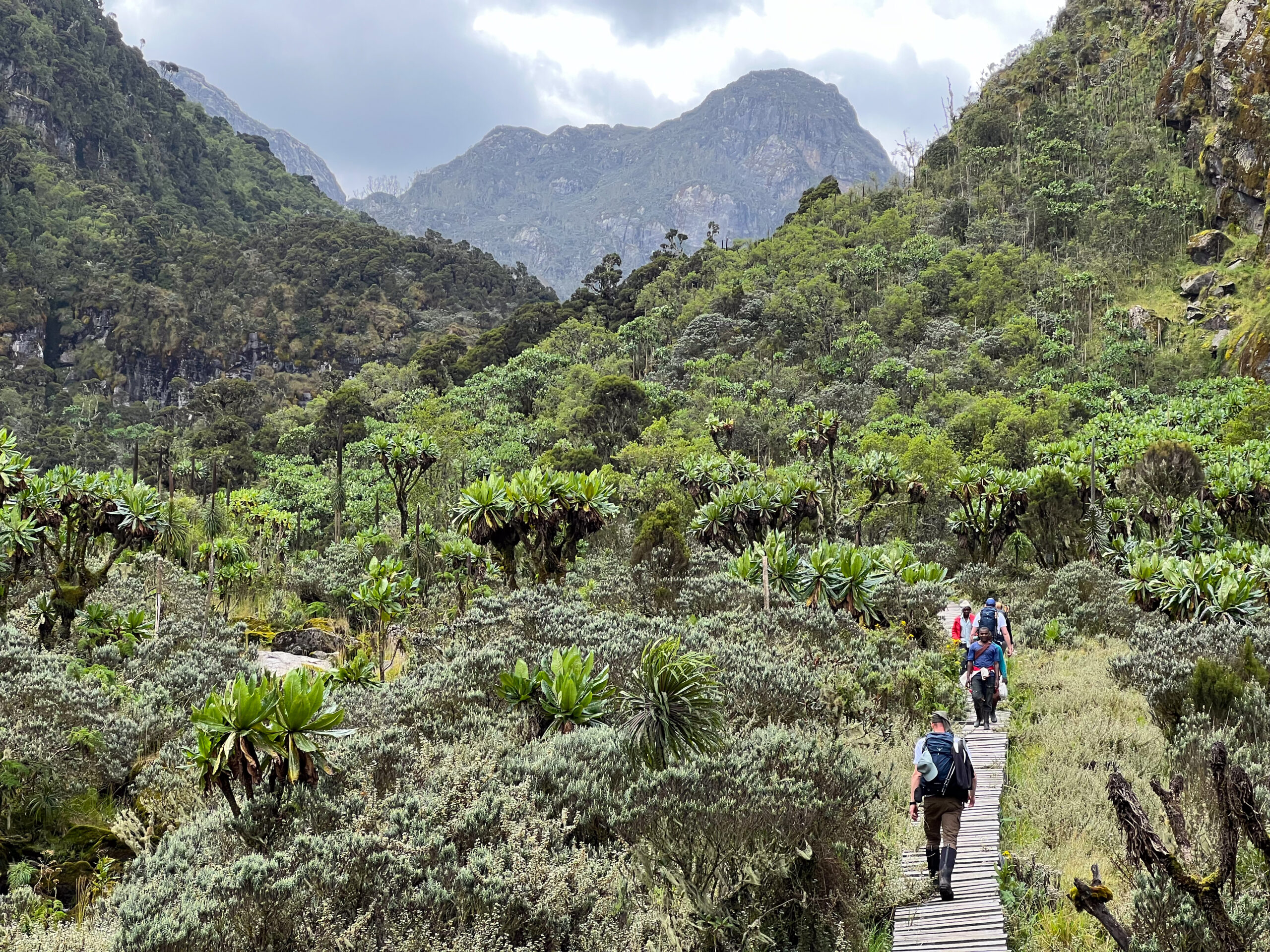
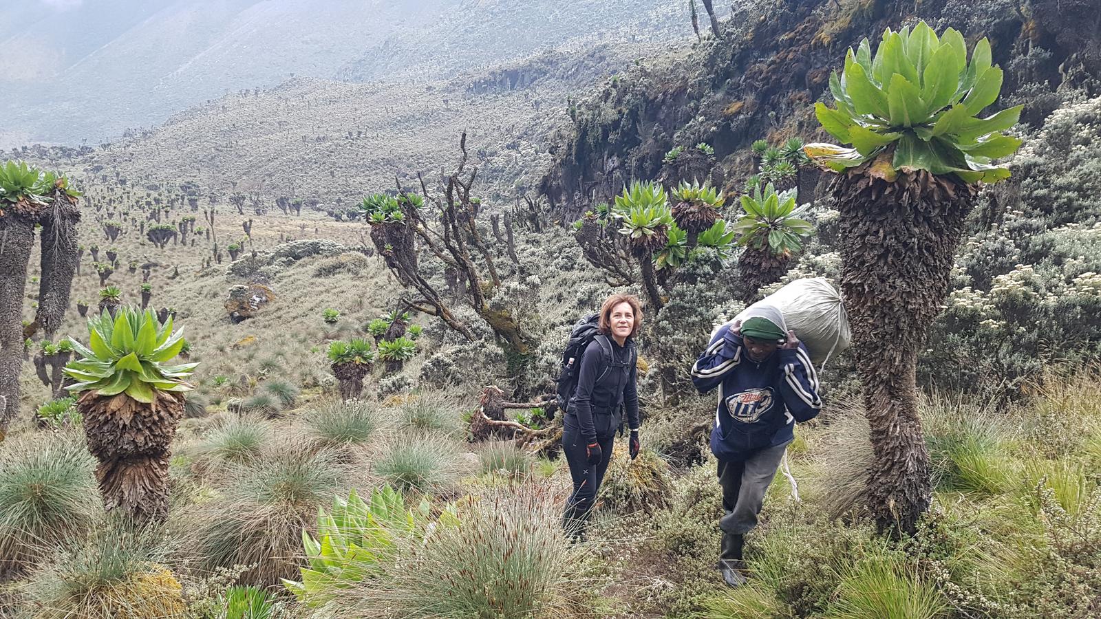
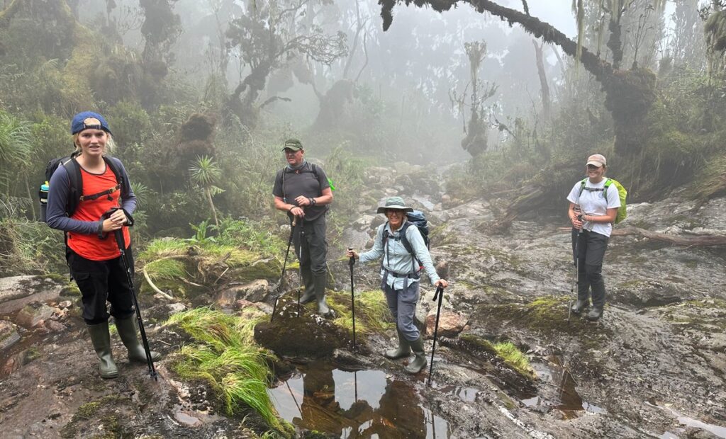
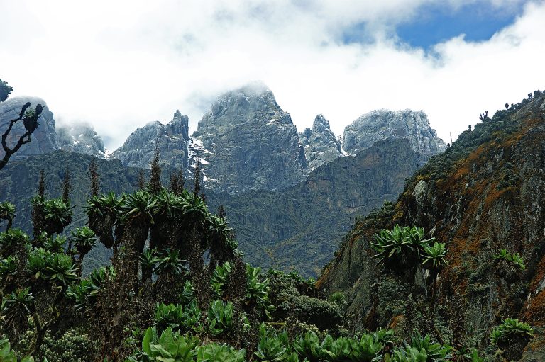
The Kilembe Trail takes you through one of the most biodiverse mountain ecosystems on Earth, starting with thick Afro-montane forests, climbing through bamboo zones, giant heather forests, boggy Afro-alpine moorlands, and finally into icy glacial terrain. Every day reveals a new landscape, a new challenge, and a new perspective on this mystical mountain range.
This 18-day Rwenzori expedition is built for seasoned trekkers, adventure athletes, and mountaineers ready to test their endurance and skills in one of the toughest high-altitude circuits in Africa. It’s long, it’s rugged, and it’s relentlessly rewarding. Completing all eight summits is a rare accomplishment, a true badge of honor for any mountaineer.
Trek Snapshot: 18-Day Rwenzori All-Peaks Expedition at a Glance
| Duration | 18 days / 17 nights on the mountain |
| Total Distance | ~140–160 km (full Kilembe Trail traverse + summit excursions) |
| Maximum Elevation | 5,109 m; Margherita Peak, Mount Stanley |
| Summits | 8 peaks across 6 Rwenzori massifs |
| Difficulty | Expert / Extreme sustained high-altitude multi-peak expedition |
| Trail | Kilembe Trail (primary) with high-mountain traverses |
| Start / End Point | Kilembe Base Camp, Kasese (1,450 m) → Kilembe Base Camp |
| Best Season | December–March (primary) | June–August (secondary) |
| Group Size | 1–8 trekkers (private departures; small groups strongly recommended) |
| Accommodation | Designated wooden mountain huts at all camps |
| Technical Gear | Provided: crampons, ice axes, harnesses, helmets, ropes, rubber boots |
| Fitness Level | Exceptional prior high-altitude multi-day trekking essential |
| Price Indicator | From $4,050 per person |
Why Attempt the 18-Day Rwenzori All-Peaks Expedition?
There are mountain expeditions, and then there is this. The 18-Day Rwenzori Trek, summiting all eight major peaks of Africa’s Mountains of the Moon in a single continuous expedition via the Kilembe Trail, is one of the rarest, most demanding, and most rewarding mountaineering achievements available anywhere on the African continent. Fewer than a few dozen trekkers attempt the full eight-peak circuit in any given year. It is not a trek that people stumble into. It is one that people spend years building toward.
The Rwenzori Mountains (Rwenzori Mountains National Park, UNESCO World Heritage Site) rise from the equatorial floor of the Western Rift Valley to glaciated summits above 5,100 metres. They contain six separate massifs: Mount Stanley, Mount Speke, Mount Baker, Mount Emin, Mount Gessi, and Mount Luigi di Savoia each with multiple subsidiary peaks, totalling eight major summits that this expedition targets. The geological and ecological journey between trailhead and the highest summit spans five distinct vegetation zones: from lowland Afro-montane rainforest, through bamboo and giant heather, into the otherworldly Afroalpine moorland, and finally onto glaciated terrain where every footstep is deliberate. No other mountain range in Africa delivers this breadth of altitudinal experience within a single continuous circuit.
Eighteen days is what the mountain demands for this challenge, not because of artificial pacing but because the terrain, elevation, and the number of summit days require it. Each summit attempt is a full day’s undertaking in itself, some requiring technical glacier travel. The traverses between massifs cross remote high-altitude passes, skirt glacial lakes, and descend into ancient carved valleys that few modern trekkers ever see. The cumulative elevation gain across all 17 hiking days is approximately 9,500–10,500 metres equivalent to climbing Kilimanjaro from sea level nearly twice over, but on far more demanding terrain.
This is also a trek with profound urgency. The Rwenzori’s glaciers have retreated by more than 80% since systematic observation began, and scientists project complete glacial loss by 2050. Summiting Margherita and Alexandra peaks, which are Africa’s second-largest remaining equatorial glaciated mountains, while genuine ice still defines the summit experience, is a privilege measured in years, not decades. The 18-Day expedition is the most complete way to witness, experience, and understand the Rwenzori before this extraordinary environment changes irrevocably.
Full Day-by-Day Itinerary: 18-Day Rwenzori Trek | Summit All 8 Peaks
Day 1: Kasese; Arrival, Equipment Check & Trek Briefing
Elevation: 914m (Kasese) | No hiking | Pre-expedition preparation day
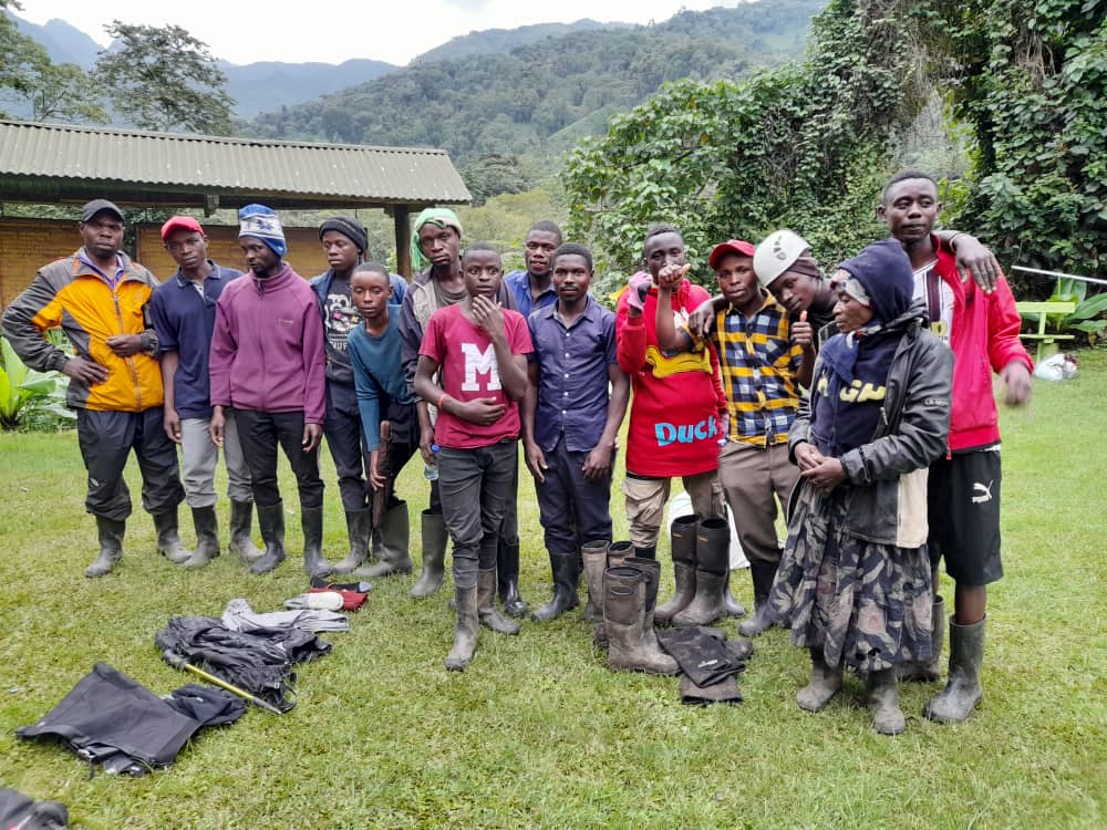
Your 18-day expedition begins the moment you arrive in Kasese, the gateway town to the Rwenzori Mountains. This is not a day to treat lightly; the quality of your preparation today determines the safety and success of the 17 days that follow. You meet your lead guide, a certified, UWA-registered mountain professional who has completed numerous multi-peak Rwenzori expeditions, and your extended support team of assistant guides and porters.
The Day 1 agenda includes a full equipment inspection (checking all personal and technical gear against the mountain’s requirements), a weather assessment and route briefing for all 18 days and contingency plans, a medical and fitness assessment (measuring blood oxygen saturation as a baseline), a permit and documentation review, and a thorough orientation to the regulations of Rwenzori Mountains National Park and Leave No Trace protocols. If you find any gear wanting, Kasese has rental options for boots, waterproofs, and sleeping bags; your guide can direct you.
In the afternoon, you rest, eat well, and hydrate. Pre-trek accommodation in Kasese is your responsibility (see our pre-trek accommodation guide); we recommend a hotel with a pool or garden where you can do light stretching and settle your nervous system. Tomorrow, the mountains begin.
Meals: Own arrangement in Kasese. Rest and hydrate. Early bedtime.
Day 2: Kilembe Base (1,450 m) → Sine Camp (2,596 m)
Distance: 9.5km | Elevation Gain: +1,146m | Hiking Time: 5–6 hours
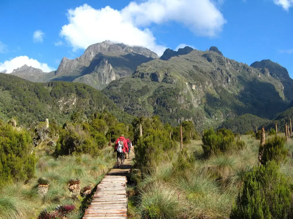
Transfer from Kasese to the Trekkers Hostel in Kilembe (12km, 20 minutes), your official starting point for the Kilembe Trail and this expedition. After a final gear-up and park permit stamping, you step onto the trail at the edge of Rwenzori Mountains National Park and begin climbing through thick Afro-montane rainforest.
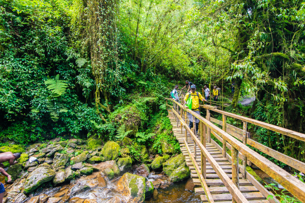
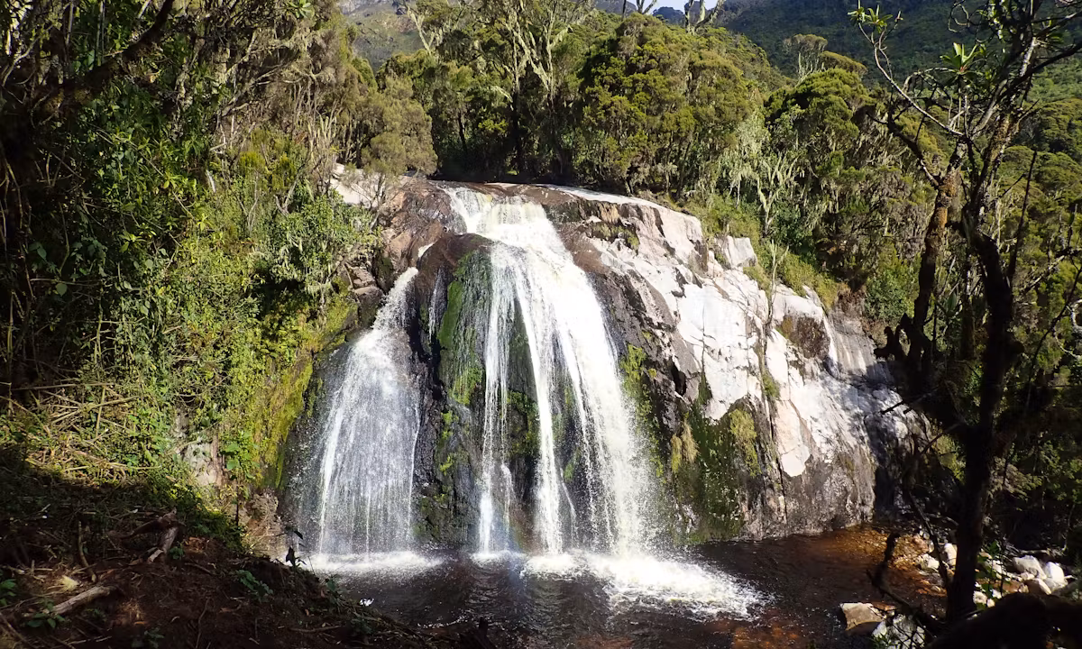
The forest on Day 2 is immediately impressive: the canopy reaches 30–40 metres, filtering equatorial light into cathedral shafts of green and gold. Rwenzori turacos flash crimson wing patches through the middle canopy; three-horned chameleons cling to mossy trunks in the understory; and blue monkeys and black-and-white colobus troops move noisily through the upper branches. The trail crosses the suspension bridge above the Nyamwamba River. Listen for the roar of the fast-flowing mountain river below before climbing steadily through an increasingly moss-draped forest to the dramatic cascade of Enock’s Falls.
The final two kilometres to Sine Camp are steep, demanding, and entirely satisfying. You arrive at 2,596m at the upper forest margin, where tree heather begins to colonize the transition zone around the huts. Dinner is hot and substantial; your mountain cook sets the standard that will sustain you for 16 more nights.
Meals: Packed lunch on trail. Hot three-course dinner and breakfast at Sine Camp.
Day 3: Sine Camp (2,596 m) → Mutinda Camp (3,688 m)
Distance: 6.5 km | Elevation Gain: +1,092 m | Hiking Time: 6–8 hours
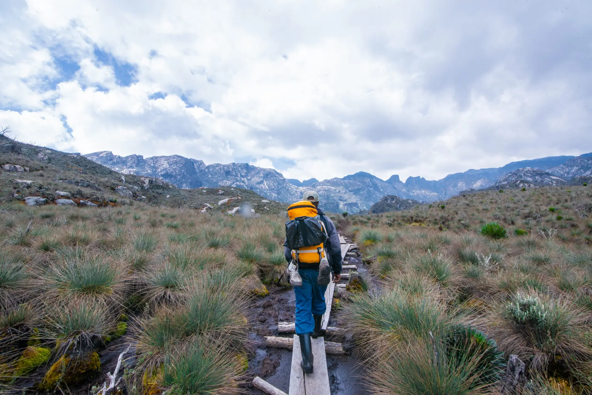
The altitude gain on Day 3 is the steepest of the entire expedition on a per-kilometer basis. You leave the forest behind and enter the bamboo zone, dense, hollow-echoing, and atmospheric, before the bamboo gives way to the Rwenzori’s signature heather forest: giant Erica arborea trees bearded with old man’s lichen (Usnea), creating a perpetual twilight that feels removed from time itself. The trail surface becomes more demanding here: root networks, wooden ladders at steep sections, and the first genuine bog crossings test your rubber boots.
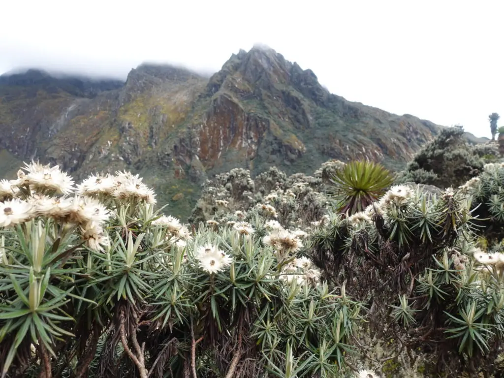
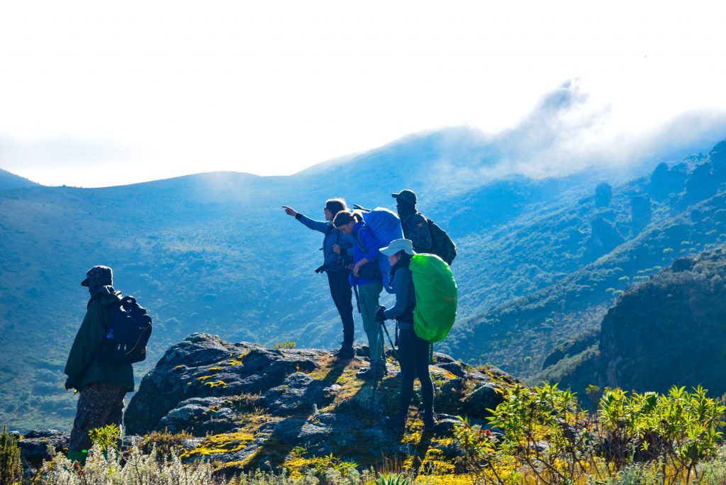
The giant lobelia (Lobelia wollastonii) makes its first significant appearance today, standing up to five metres in silver-grey splendor above the heather floor. Dendrosenecio groundsel trees, some centuries old, punctuate the ridgelines. At the top of the main ascent, Mutinda Camp (3,688 m) sits on an open ridge with wind shelter from surrounding heathers. The option to make a short acclimatization excursion to the nearby viewpoint at 3,925 m delivers a first panorama of the massifs ahead, an essential morale boost and physiological preparation for what follows.
Meals: Hot breakfast at Sine. Packed lunch on trail. Hot dinner at Mutinda Camp.
Day 4: Mutinda Camp (3,688 m) → Bugata Camp (4,062 m)
Distance: 8.6 km | Elevation Gain/Loss: +374 m (with valley traverses) | Hiking Time: 5–7 hours
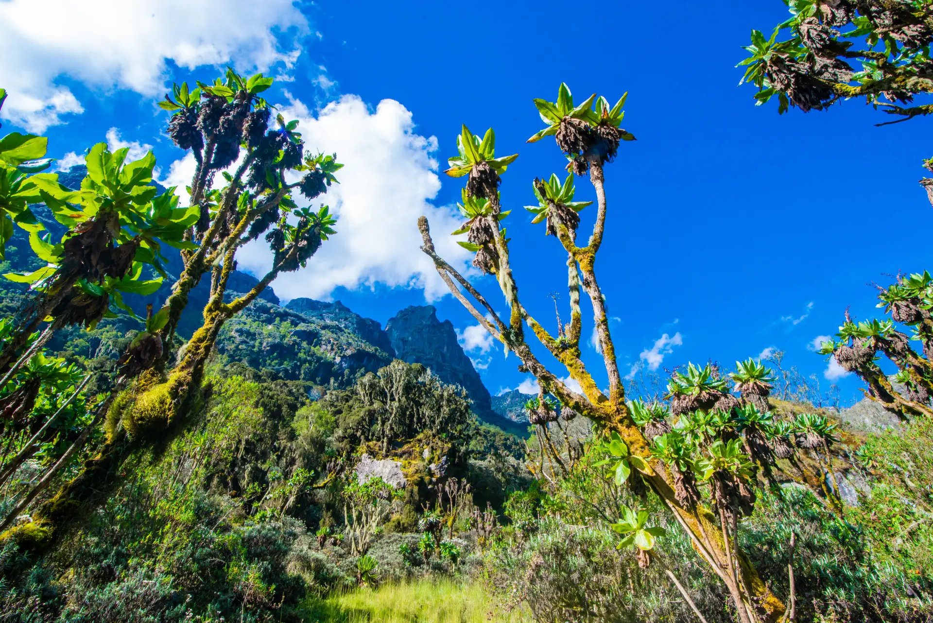
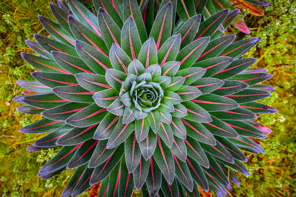
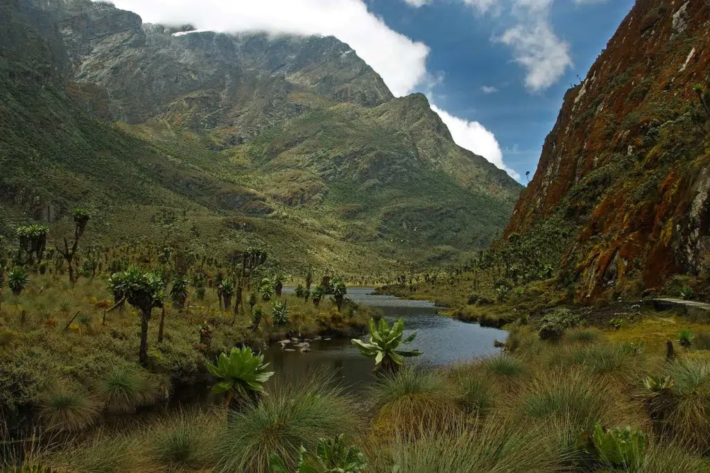
Day 4 carries you into the full Afroalpine world. The Namusangi Valley corridor is the botanical heart of the Rwenzori, with giant lobelias up to six metres tall, centuries-old Dendrosenecio groundsel trees, everlasting flowers (Helichrysum) covering the open moorland in silver and white, and cushion plants filling the bogs between rock outcrops. This landscape has no equivalent anywhere else in the world; it is a product of millions of years of evolutionary isolation at equatorial altitude.

Several substantial waterfalls punctuate the valley floor, fed by meltwater from the glaciers above. As the valley broadens, the sky opens noticeably, revealing for the first time the glaciated flanks of the higher peaks clearly visible above the ridgeline, with thin white ribbons on dark Precambrian rock. Bugata Camp, at 4,062 m, sits on a natural platform with unobstructed evening views of Weismann Peak, tomorrow’s first summit. The temperature drops sharply after sunset; all thermal layers come out tonight.
Meals: Hot breakfast at Mutinda. Packed lunch on trail. Hot dinner at Bugata Camp.
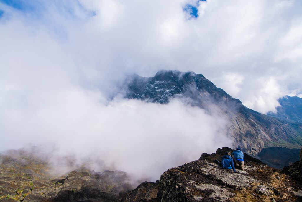
Day 5: SUMMIT 1: Weismann Peak (4,620 m) → Return to Bugata Camp (4,062 m)
Round Trip: ~8km | Elevation Gain: +558m | Summit Time: 6–8 hours
⛰️ PEAK 1 OF 8 — Weismann Peak, 4,620m (Mount Luigi di Savoia)
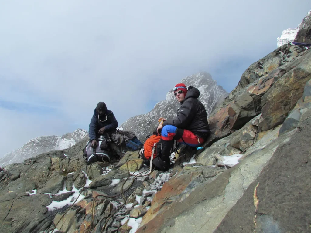
Your first summit. Weismann Peak is the higher of the two summits on Mount Luigi di Savoia (the other being Sella Peak) and stands at 4,620 m the southernmost of the Rwenzori’s major massifs. The ascent from Bugata Camp climbs rocky terrain above the alpine bog, gaining the ridge system that leads to the summit plateau. The route does not require technical glacier equipment, making it a physically demanding but non-technical summit that serves as an ideal physiological and psychological primer for the harder peaks to come.
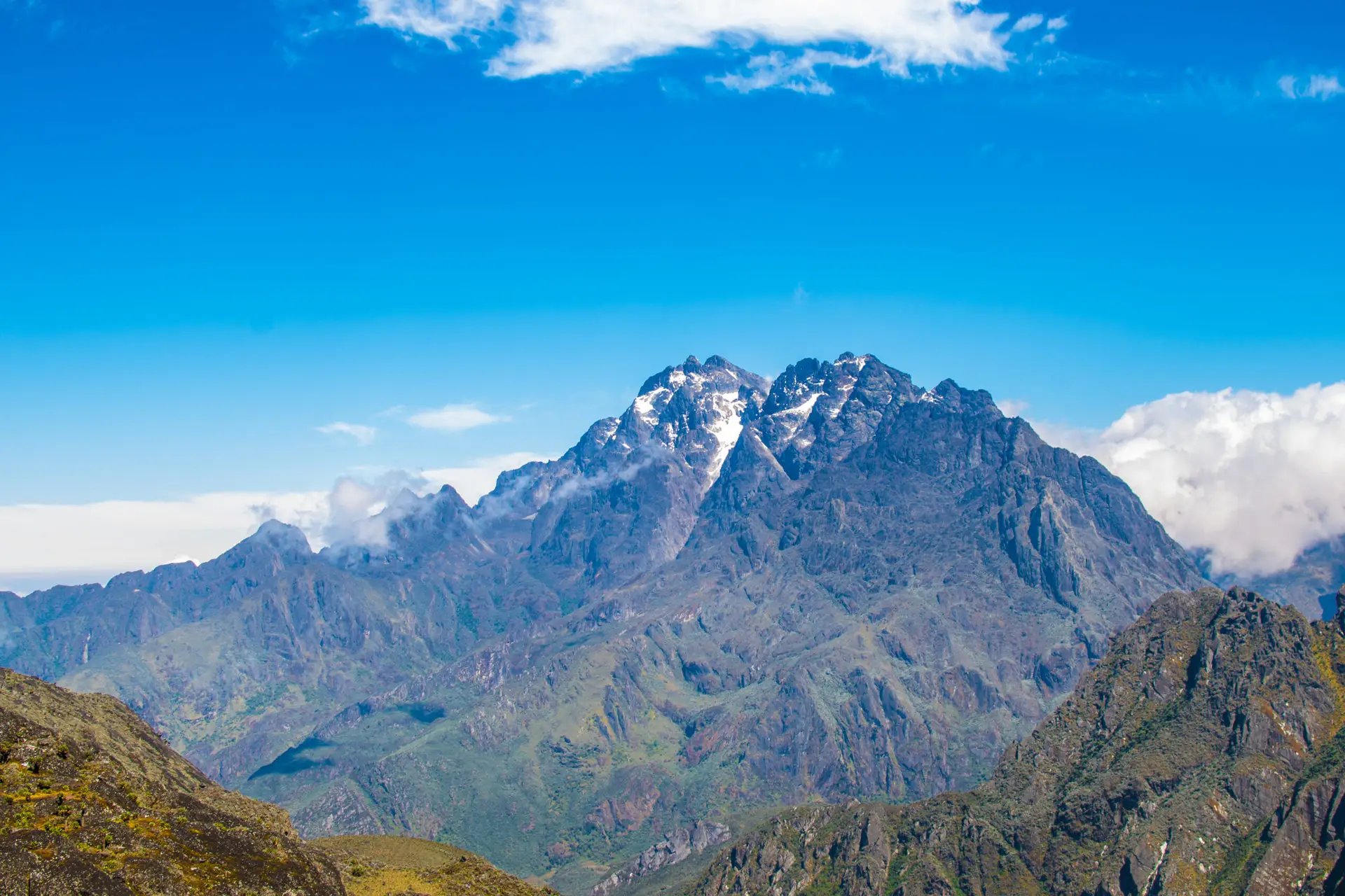
From Weismann’s summit on a clear morning, the Rwenzori spine reveals itself for the first time in its full scope: Mount Baker to the north, Mount Stanley’s glaciated crown beyond it, and the rolling moorlands below. The panorama is one of the finest in the range. The descent returns to Bugata Camp by mid-afternoon; eat, hydrate aggressively, and rest. The expedition has begun in earnest.
Summit departure: 5:00–6:00am. Return to camp by early afternoon. Hot dinner at Bugata.
Day 6: Bugata Camp (4,062 m) → Bamwanjara Pass → Butawu/Hunwick's Camp (3,974 m)
Distance: 8.3 km | Gain/Loss: +388 m / -476 m | Hiking Time: 6–8 hours
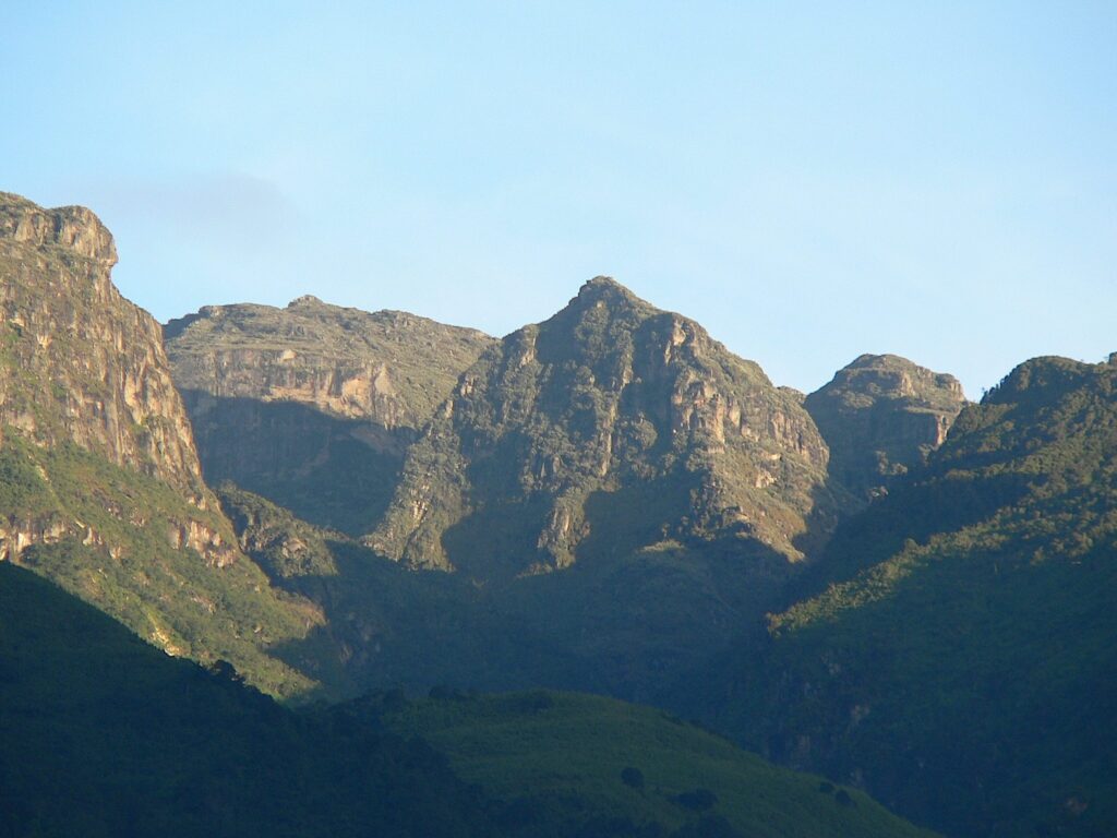
Day 6 is one of the expedition’s remarkable traverse days. The route climbs from Bugata Camp to Bamwanjara Pass at 4,450 m, the high point between the southern and central massifs, before descending into the valley leading toward Mount Baker. Bamwanjara Pass is worth pausing at: the simultaneous view of Mount Stanley (northwest), Mount Baker (north), and Mount Speke (northeast), all glacier-bearing and monumental, is the expedition’s first multi-peak panorama and one of the defining views of the entire Rwenzori range.
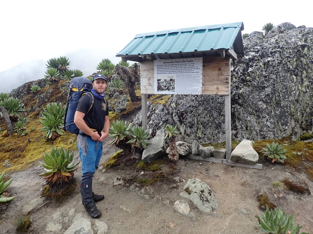
The descent from the pass crosses glacially scoured rock and ancient moraine deposits geological storytelling written in stone about the vastly larger glaciers that dominated these mountains thousands of years ago. Butawu/Hunwick’s Camp, at 3,974 m, sits in a sheltered position that will become familiar: this camp serves as the operational base for the Mount Baker summit attempt tomorrow. Tonight’s briefing covers the Baker approach in detail. Review your crampon and ice axe techniques with your guide after dinner.
Meals: Hot breakfast at Bugata. Packed lunch at or near the pass. Hot dinner at Butawu Camp.
Day 7: SUMMIT 2: Mount Baker, Edward Peak (4,844m) → Return to Butawu Camp
Round Trip: ~9km | Elevation Gain: +870m | Summit Time: 7–10 hours
🥉 PEAK 2 OF 8 — Edward Peak, 4,844m (Mount Baker)
The pre-dawn alarm sounds at 4:00 am. This is your second summit, and it is the first one that requires technical gear. Climbers reach Mount Baker’s Edward Peak, at 4,844 m, via a sustained rocky ascent that transitions into a short glacial section near the summit ridge. Crampons are fitted at the glacier’s edge; your guide clips the rope, and the summit team moves as one. Although the Baker glacier is smaller than Stanley’s and the ropework is less extensive, the technical environment is genuine: do not underestimate it.
The pre-dawn climb by headlamp is one of the expedition’s experiential highlights. As sunrise ignites the eastern sky, the silhouette of Mount Stanley’s twin glaciated peaks emerges to the northwest. At this moment, you fully grasp the scale of what you are undertaking. Edward Peak at 4,844 m delivers views of the Freshfield Pass corridor, the remnant Baker glacier, and the high ridgeline connecting Baker to the Stanley massif. The descent returns to Butawu Camp for an extended rest, recovery, and replenishment before tomorrow’s transition day.
Summit departure: 4:00–4:30 am. Return to camp: midday to early afternoon. Hot dinner at Butawu Camp.
Day 8: Butawu Camp (3,974 m) → Lake Kitandara → Margherita Camp (4,485 m)
Distance: ~5.5 km | Elevation Gain: +511 m | Hiking Time: 4–6 hours
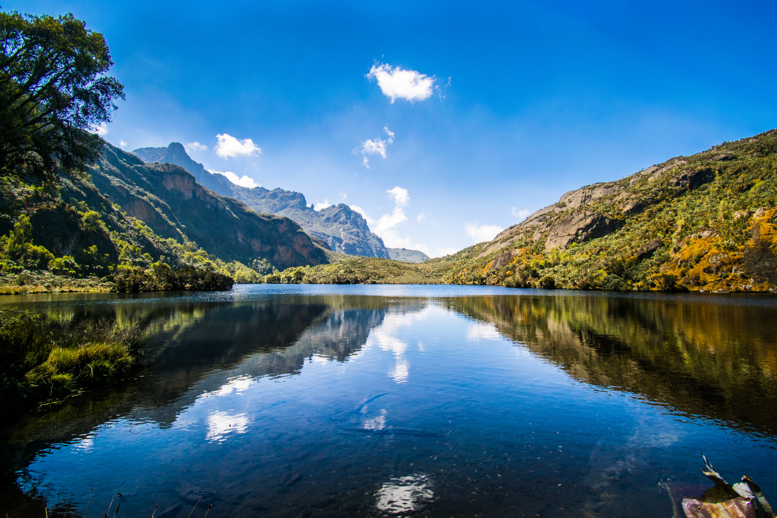
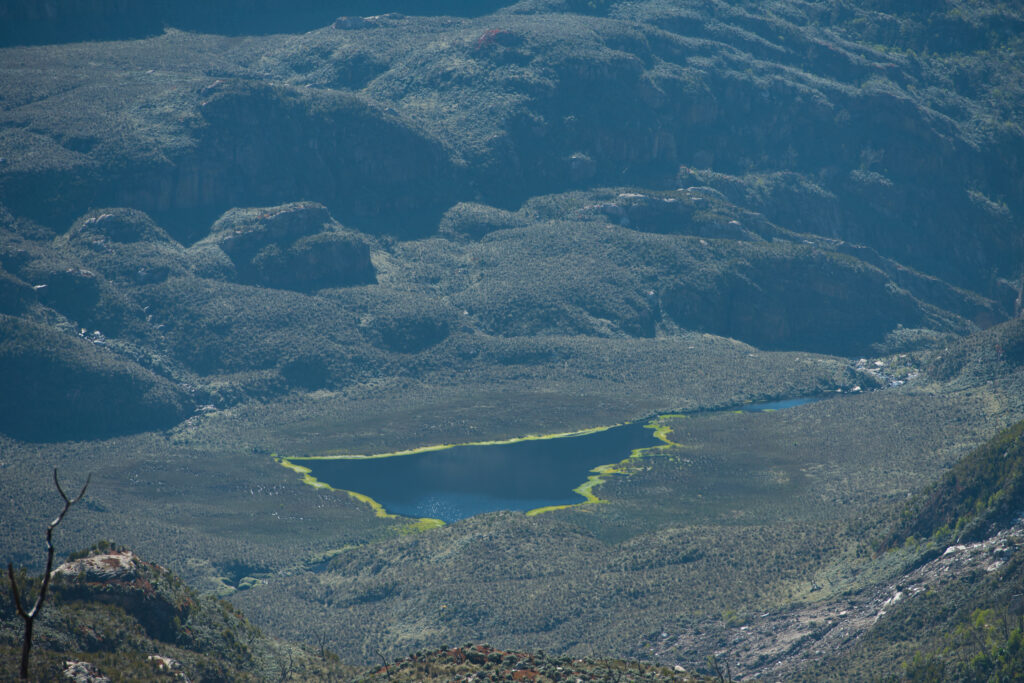
Day 8 is a transitional day with two objectives: move to the base of Mount Stanley and allow your body one final night of moderate-altitude rest before the glacier summits. The route from Butawu descends briefly to Lake Kitandara at approximately 4,023 m, one of the most beautiful high-alpine lakes in East Africa. Dark water perfectly mirrors the rock walls above; on windless mornings, the reflection is so precise it takes a moment to determine which way is up.
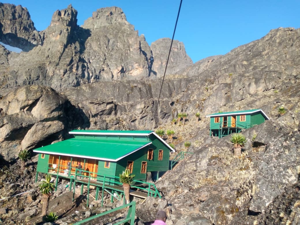
From Lake Kitandara, the trail climbs via Scott Elliott’s Pass (approximately 4,372 m), named for the 1895 explorer who first mapped these valleys. The pass marks the transition to the Stanley approach zone; beyond it, the terrain becomes increasingly rocky and exposed, with the Margherita glacier visible above. Margherita Camp, at 4,485m is the highest permanent camp on the Kilembe Trail, a cluster of solid huts on a narrow shelf below the glacier’s terminal moraine. Eat everything on your plate tonight, drink more than you think necessary, and sleep as early as possible. The alarm is set for 4:00 am.
Meals: Hot breakfast at Butawu. Packed lunch on trail. Early, substantial hot dinner at Margherita Camp.
Day 9: SUMMIT 3: Margherita Peak (5,109 m) → Rest at Margherita Camp
Round Trip from camp: ~5 km | Elevation Gain: +624 m | Summit Time: 7–10 hours
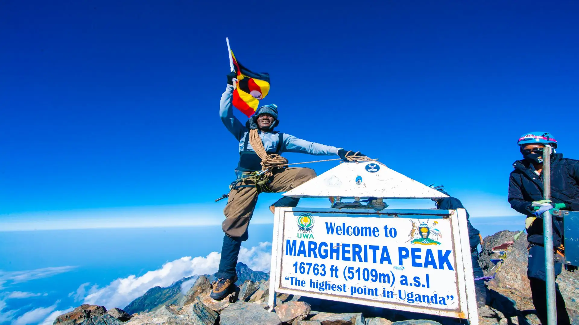
🥇 PEAK 3 OF 8: Margherita Peak, 5,109 m Africa’s Third Highest Summit
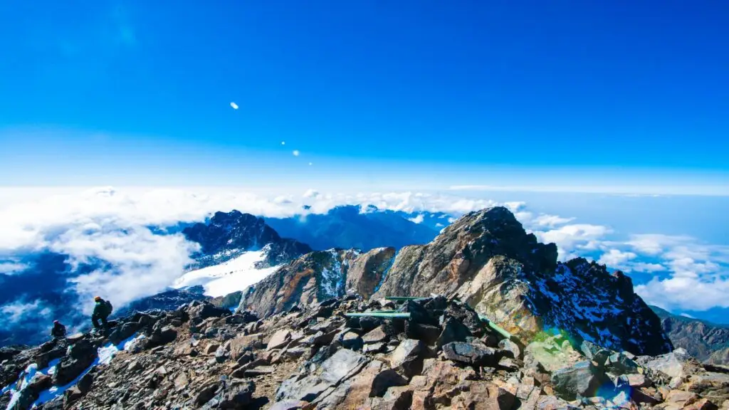
Africa’s third-highest point. The Roof of the Rwenzori. This is the most technically demanding summit of the expedition, and it is the one for which everything else has been preparation. The alarm at 4:00am, sometimes 3:30am, brings a moment of crystalline clarity: today is the day.
You depart in full darkness, in temperatures between -5°C and -15°C depending on the season and wind. The first section climbs rocky terrain above camp by headlamp; then the headlamps catch the faint glimmer of the Stanley Glacier above. Crampons are fitted, and the rope team assembles. The glacier approach to Margherita Peak is the most serious technical terrain of the entire expedition; crevasses exist, the surface is genuinely icy, and fixed ropes protect the steepest sections. Your guide’s experience here is non-negotiable.
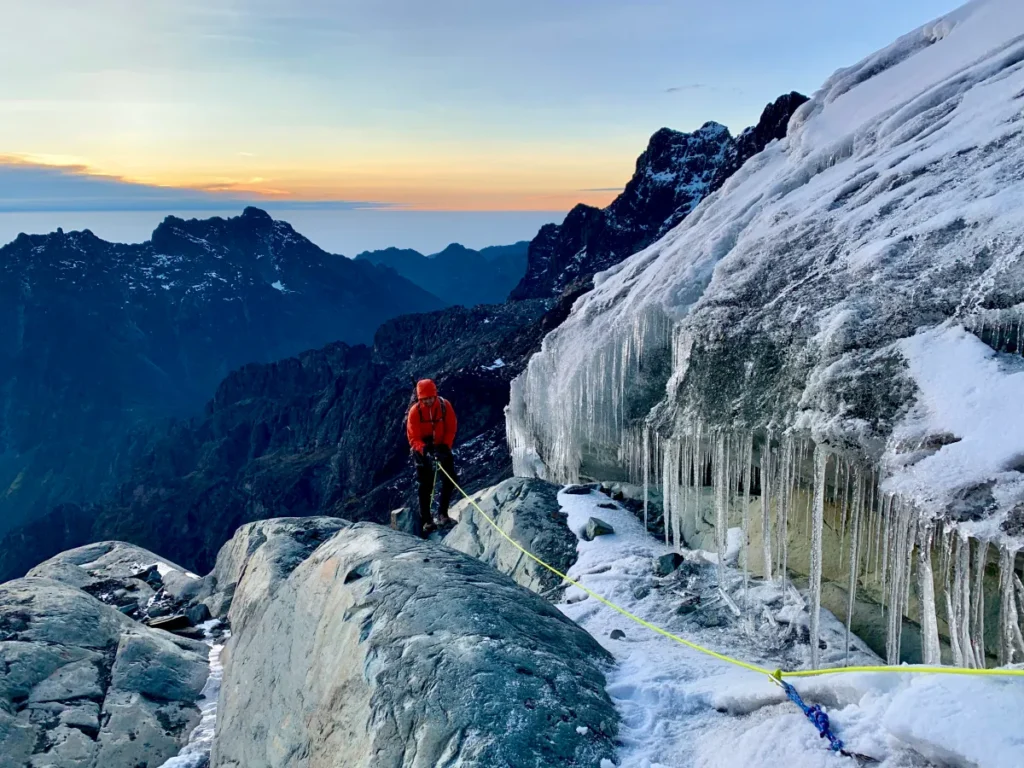
The summit arrives with the full force of earned altitude: 5,109 metres above sea level, standing on ice that has persisted through millennia of equatorial sun, ice that is now retreating irreversibly. On a clear summit morning, the DRC’s Virunga volcanic chain is visible to the south, and the expanse of Uganda’s Western Rift Valley stretches east. The descent to Margherita Camp takes 2–3 hours; rest completely for the remainder of the day. Tomorrow brings Alexandra Peak.
Summit departure: 3:30–4:00 am. Return to Margherita Camp by early afternoon. Rest thoroughly.
Day 10: SUMMIT 4: Alexandra Peak (5,083m) → Return to Margherita Camp.
Round Trip from camp: ~4 km | Elevation Gain: +598 m | Summit Time: 6–9 hours
🥈 PEAK 4 OF 8: Alexandra Peak, 5,083 m (Mount Stanley)
Alexandra Peak (5,083 m) is Mount Stanley’s second-highest summit, separated from Margherita by an icy ridge traverse that is technically the most demanding single section of the entire 18-day expedition. The two peaks are visually close, perhaps 500 metres of horizontal distance, but between them lies a glaciated arête that requires full technical rope discipline, careful crampon placement, and complete trust in your guide.
Many trekkers find Alexandra psychologically harder than Margherita despite its 26-meter lower elevation: the summit day after Margherita’s exertions compounds the cumulative fatigue, and the icy ridge traverse is more exposed than any section on the Margherita route. However, the mountaineers who complete both summits consistently report Alexandra as the more memorable of the two; the sense of moving on genuine alpine terrain at over 5,000 m on the equator is extraordinary. Summit views from Alexandra look down onto the Elena Glacier and across to the approach routes you have just completed.
Return to Margherita Camp and rest as completely as your body allows. You have now completed 4 of 8 summits on the roof of Africa. Tomorrow begins the traverse toward Mount Speke.
Summit departure: 5:00–6:00 am. All summit days require full technical gear. Return by early afternoon.
Day 11: Margherita Camp (4,485 m) → Elena Camp / Speke Base (~4,300–4,500 m)
Distance: ~7–9 km | Complex, traversing terrain | Hiking Time: 6–8 hours
Day 11 begins the central traverse, the most remote and technically demanding movement section of the expedition. You descend from Margherita Camp and begin contouring around the Stanley massif via steep rocky terrain, crossing high scree slopes and glacial moraines that form the connecting geography between the Stanley and Speke massifs. This traverse passes through terrain rarely seen by any but the most committed Rwenzori expedition members.
Elena Camp, positioned between Stanley and Speke, serves as your staging point for the Mount Speke summit attempt. The camp’s position on an exposed rocky shelf means you will feel every degree of temperature drop after dark; windproof layers and a high-quality sleeping bag are absolutely essential here. Your guide will assess conditions, weather, and group fitness this evening before confirming the Speke summit plan.
Meals: Hot breakfast at Margherita Camp. Packed lunch on traverse. Hot dinner at Elena/Speke base camp.
Day 12: SUMMIT 5: Mount Speke; Vittorio Emanuele Peak (4,890 m) → Return to Camp
Round Trip from camp: ~7 km | Elevation Gain: ~400–500 m | Summit Time: 6–8 hours
⛰️ PEAK 5 OF 8: Vittorio Emanuele Peak, 4,890 m (Mount Speke)
Mount Speke (4,890 m) is the Rwenzori’s second-highest massif, and its summit, Vittorio Emanuele Peak, offers a character entirely different from the Stanley summits. The ascent typically involves less glacier travel but more sustained rocky scrambling on the upper ridges, with sections that require sure hands and calm decision-making on exposed terrain. Speke’s summit is frequently enveloped in the Rwenzori’s characteristic swirling mist, a condition that, far from being a disappointment, creates one of the most atmospherically extraordinary summit experiences in African mountaineering.
On a clear morning from Vittorio Emanuele Peak, the full arc of the Rwenzori spine is visible: Mount Stanley behind you, the northern peaks of Emin and Gessi ahead, and the magnificent glacial cirques below. This is the expedition’s geographic apex, the moment from which all other peaks are visible simultaneously. The descent returns to camp in time for rest and caloric replenishment. Two more northern peaks await.
Summit departure: 5:00 am. Return to camp by mid-afternoon. Rest and nutrition priority.
Day 13: Traverse: Speke Base → Northern Peaks Base Camp (~3,800–4,200 m)
Distance: ~10–12 km | Complex terrain | Hiking Time: 7–9 hours
Day 13 is the expedition’s great connector, a long, demanding traverse through the northern section of the Rwenzori high country, descending from the Speke-Stanley zone and moving into the territory of the Rwenzori’s remotest massifs: Emin and Gessi. This traverse crosses valleys dominated by ancient Dendrosenecio groundsel trees of extraordinary size, specimens that may be over a century old, their umbrella-shaped crowns creating a landscape that genuinely has no parallel anywhere on earth.

The northern zone of the Rwenzori sees far fewer visitors than the Stanley-Baker corridor, and the sense of remoteness on Day 13 is tangible. Your porter team navigates terrain that requires intimate route knowledge; the camp tonight is positioned to access both Mount Emin and Mount Gessi on consecutive days. Dinner carries particular importance: you are entering the final summit cluster of the expedition.
Meals: Hot breakfast. Packed lunch. Hot dinner at northern base camp.
Day 14: SUMMIT 6: Mount Gessi; Bottego Peak (4,715 m) → Return to Camp
Round Trip: ~8 km | Elevation Gain: ~500–600 m | Summit Time: 6–9 hours
⛰️ PEAK 6 OF 8: Bottego Peak, 4,715 m (Mount Gessi)
Mount Gessi (4,715 m) is one of the Rwenzori’s most dramatic and least-climbed massifs. Its summit, Bottego Peak, is reached via steep rocky ledges and exposed scramble terrain that offers the most significant vertical drop-offs of any summit on this expedition. The rock architecture of Gessi is ancient Precambrian gneiss and granite, sculpted by glacial action into sharp arêtes and vertiginous faces that require careful route-finding and steady nerves.
The summit panorama from Bottego Peak at 4,715 m shows the full complexity of the northern Rwenzori: the Emin massif to one side, the receding glaciers of Stanley visible to the south, and the enormous altitudinal drop to the east toward the Rift Valley floor. Few mountaineers in any year stand on this summit. Return to camp by afternoon for rest and preparation for Mount Emin tomorrow.
Summit departure: 5:00–5:30 am. Return by early afternoon. Full rest before Emin.
Day 15: SUMMIT 7: Mount Emin: Umberto Peak (4,798 m) → Return to Camp
Round Trip: ~9 km | Elevation Gain: ~600–700 m | Summit Time: 7–10 hours
⛰️ PEAK 7 OF 8: Umberto Peak, 4,798 m (Mount Emin)
Mount Emin (4,798m) is named for the remarkable Emin Pasha Eduard Schnitzer, the German-born Ottoman governor of Equatoria whose rescue was one of the stated justifications for Henry Morton Stanley’s famous 1887–1889 expedition that brought the Rwenzori to European awareness. Umberto Peak, the summit of Emin, is reached via exposed, sharp-edged ridgeline terrain with sections of genuine scrambling on loose rock that demand concentration.
By Day 15, your body carries seventeen days of accumulated effort. The legs are strong but aware of their load; the lungs are adapted to altitude but feel every additional meter. This is precisely when expedition experience becomes vital: the discipline to move slowly and steadily, eat and drink consistently, and trust that the summit will come. Umberto Peak at 4,798m delivers the penultimate summit of the expedition, and the descent to camp carries the particular satisfaction of knowing that only one more peak remains.
Summit departure: 5:00am. Return to camp by early afternoon. Celebrate carefully; you have one more day.
Day 16: Northern Base → Traverse South → Bugata Camp (4,062 m)
Distance: ~12–15 km | Long descent and re-ascent | Hiking Time: 8–10 hours
Day 16 closes the northern loop of the expedition and begins the return journey southward through the Rwenzori’s interior. The long traverse descends from the Emin-Gessi zone, crosses the moorland valleys, and reascends to Bugata Camp at 4,062 m, a camp you left on Day 5 to begin the summit sequence. Returning to Bugata now, with seven of eight peaks behind you, the camp feels different: familiar, earned, and charged with the knowledge of what the surrounding peaks have asked of you.
The traverse crosses some of the most botanically rich terrain of the entire expedition at the transitions between vegetation zones. At this stage of the trip, every element of the Rwenzori’s character is known to you: the smell of the Afro-alpine bog, the sound of wind through the heather groves, and the particular quality of light that happens just after dawn when mist is burning off the ridges. Bugata Camp tonight is a rest station before the final push to Summit 8 tomorrow.
Meals: Hot breakfast. Packed lunch on traverse. Hot dinner at Bugata Camp.
SUMMIT 8: Cheptegei Peak (4,907 m); Optional via Bugata Approach
Summit excursion from Bugata area | Elevation: 4,907 m | Time: 6–8 hrs if attempted
⛰️ PEAK 8 OF 8: Cheptegei Peak, 4,907 m (Mount Stanley massif)
Cheptegei Peak (4,907 m), positioned on the Stanley massif above the Bugata approach zone, is the expedition’s eighth and final summit. Its elevation places it above Speke, Emin, Gessi, and Luigi di Savoia, a summit of genuine distinction that is rarely included in even the most ambitious Rwenzori itineraries. Access from the Bugata Camp area involves a direct ascent on rocky terrain above the alpine zone, with scrambling sections on the upper ridge.
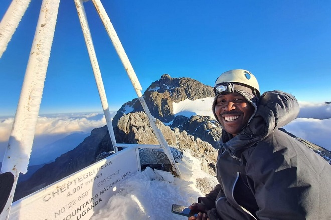
Whether Cheptegei attempts it depends on group fitness assessment, weather conditions, and your guide’s judgment after 15 days of sustained high-altitude effort. Our experienced expedition guides will advise honestly: if the conditions favor a summit attempt and the group is genuinely capable, you go. If conditions or cumulative fatigue makes it inadvisable, the safety call is made. This is not a compromise of the expedition’s integrity; it is precisely the kind of professional judgment that keeps Rwenzori expeditions safe. In either case, you return to Bugata Camp before descending.
Summit attempt dependent on conditions and group assessment. Full rest day at Bugata if not attempted.
Day 17: Bugata Camp (4,062 m) → Sine Camp (2,596 m)
Distance: ~13 km | Elevation Loss: -1,466 m | Hiking Time: 5–7 hours
The descent begins. After spending days at altitude, the majority of the expedition, which was above 3,500 m, dropped through the altitudinal zones in reverse, creating a profound sensory experience. The vegetation visibly thickens with every hundred metres of descent. The temperature rises. The air grows denser. Bird calls return: turacos, sunbirds, and flycatchers create the rich avian soundtrack of the forest that was absent for over a week. The giant lobelias and groundsel trees of the moorland yield way to heather, then bamboo.
Sine Camp (2,596 m), reached in the mid-afternoon, feels almost tropical after the high camps. The sound of the forest at night insects, distant water, occasional monkey calls is a reminder of the scale of the vertical world you have crossed. Tonight’s dinner carries the quiet dignity of a completed expedition.
Meals: Hot breakfast at Bugata. Packed lunch on trail. Hot dinner at Sine Camp
Day 18: Sine Camp (2,596 m) → Kilembe Base Camp (1,450 m) → Kasese
Distance: 9.5 km | Elevation Loss: -1,146 m | Hiking Time: 4–5 hours
The final morning on the mountain. The Nyamwamba Valley carries you home through a lower forest alive with duikers, colobus monkeys, and the full orchestral complexity of Afro-montane bird life. The air is thick, warm, and fragrant after seventeen days of thin, cold, mineral-scented mountain air. Every footstep of the descent is a recalibration back to the lowland world.
After the final forest section, the Trekkers Hostel in Kilembe comes into view. Boots come off. The equipment team accounts for all gear. Porter tips are distributed with the genuine warmth and respect these mountain professionals have earned over 18 days of extraordinary effort. A transfer vehicle returns you to Kasese in 20 minutes. You have completed one of the rarest mountaineering achievements in Africa: all eight major Rwenzori peaks in a single continuous expedition, from first step to last.
Meals: Hot breakfast at Sine Camp. Packed lunch on trail. Celebration dinner in Kasese (own arrangement).
Elevation Profile: The Arc of the 18-Day Expedition
Complete Elevation Arc: 18-Day Rwenzori All-Peaks ExpeditionDay 1: 914 m (Kasese) Briefing and preparation Day 2: 1,450 m → 2,596 m (+1,146 m) Kilembe Base to Sine Camp Day 3: 2,596 m → 3,688 m (+1,092 m) Sine Camp to Mutinda Camp Day 4: 3,688 m → 4,062 m (+374 m) Mutinda Camp to Bugata Camp Day 5: 4,062 m → 4,620 m → 4,062 m (+558 m / -558 m) Weismann Peak summit Day 6: 4,062 m → 4,450 m → 3,974 m (+388 m / -476 m) Bamwanjara Pass traverse Day 7: 3,974 m → 4,844 m → 3,974 m (+870 m / -870 m) Mount Baker summit Day 8: 3,974 m → 4,023 m → 4,485 m (+511 m) Kitandara → Margherita Camp Day 9: 4,485 m → 5,109 m → 4,485 m (+624 m / -624 m) Margherita Peak summit Day 10: 4,485 m → 5,083 m → 4,485 m (+598 m / -598 m) Alexandra Peak summit Day 11: 4,485m → ~4,300–4,500m Stanley-Speke traverse to Elena Camp Day 12: ~4,300 m → 4,890 m → ~4,300 m (+500–600 m) Mount Speke summit Day 13: ~4,300 m → ~3,800–4,200 m Long traverse to northern base camp Day 14: ~4,000 m → 4,715 m → ~4,000 m (+600 m) Mount Gessi summit Day 15: ~4,000 m → 4,798 m → ~4,000 m (+700 m) Mount Emin summit Day 16: ~4,000 m → 4,907 m → 4,062 m (+900 m) Cheptegei Peak + Bugata Camp Day 17: 4,062 m → 2,596 m (-1,466 m) Long descent to Sine Camp Day 18: 2,596 m → 1,450 m (-1,146 m) Descent to Kilembe Base & Kasese Total Cumulative Elevation Gain: ~9,500–10,500m across 17 hiking days |
Camps & Accommodation: Where You Sleep on the 18-Day Trek
All accommodation on this expedition is in Uganda Wildlife Authority-designated wooden mountain huts at established camps within the Rwenzori Mountains National Park. Huts provide essential protection from rain, wind, and temperature extremes. Sleeping arrangements are communal bunk beds with mattresses; you supply your sleeping bag. Facilities are functional but not luxurious: pit latrines, mountain water sources (filter before drinking), and a cooking area where your mountain cook prepares all meals. Below are the primary camps on this itinerary:
Sine Camp 2,596 m
Your first mountain camp is at the upper margin of the Afro-montane forest. Used on both Days 2/3 and 17/18. Well-maintained wooden huts with bunk beds. The forest surrounds the camp closely; night sounds include owls, tree hyrax, and distant water. The warmest camp on the expedition.
Mutinda Camp, 3,688 m
Heather and moorland zones, open ridge positions with views east over Kasese and the Rift Valley plains. Temperature drops to 2–5°C at night. The optional acclimatization excursion to the 3,925m viewpoint is ideally done from here.
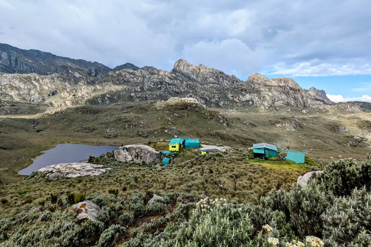
Bugata Camp, 4,062 m
Alpine zone gateway camp, used multiple times on this expedition. Open plateau position with unobstructed views of Weismann Peak and the southern peaks. Temperature regularly drops below freezing at night. Bugata is the staging point for the Weismann summit and a critical rest stop on both the outward and return traverses.
Butawu / Hunwick’s Camp: 3,974 m
Sheltered valley position serving as the Mount Baker staging camp. Used for two nights (Days 6–7). The camp is positioned for a clear early-morning departure toward Baker’s glacier. Strategic and well-placed for the expedition’s pacing.
Margherita Camp, 4,485 m
The highest permanent camp on the Kilembe Trail is used for two critical nights (Days 8–9 / Days 9–10). The area is Spartan, cold (between -5°C and -12°C), and extraordinary in its position directly below Stanley Glacier. Very few trekkers in Uganda sleep this high. Every calorie and hour of sleep here is an investment in summit success.
Elena Camp / Speke Base ~4,300–4,500 m
A high traverse camp is positioned between the Stanley and Speke massifs. In exposed locations, wind is common. This camp rarely sees use except by the most committed multi-peak expeditions; you will likely have it entirely to yourself.
Northern Base Camp (Emin/Gessi Zone) ~3,800–4,200 m
A strategically positioned camp for accessing the northern peaks of Emin and Gessi on consecutive days. This site, which is the northernmost established camp system in the Rwenzori, is among the least visited overnight locations in the entire park.
Flora & Wildlife: What You Will Encounter Across 18 Days
Eighteen days on the Rwenzori means 18 days inside one of Africa’s most distinctive and biodiverse mountain ecosystems. No other Rwenzori itinerary gives you this depth of botanical and wildlife immersion. The full altitudinal sequence from forest to glacier crosses multiple times.
Afro-Montane Forest Zone (1,450 m–2,600 m)
The issue was encountered on Days 2, 17, and 18. Rwenzori turacos with their crimson wing panels, black-and-white colobus and blue monkeys, Rwenzori batis, Cameroon sunbirds, African goshawks, three-horned chameleons, forest orchids, tree ferns, and dense epiphyte-laden canopy. This area is one of the Rwenzori’s most bird-rich zones; serious birders should carry binoculars.
Bamboo & Lower Heather Zone (2,600 m–3,300 m)
Encountered on Days 3 and 17. Dense bamboo (Arundinaria alpina) transitions to giant tree heather (Erica arborea) draped with old man’s beard lichen. Buffalo evidence is occasionally found here. The start of the giant lobelia appears in the upper bamboo transition. The forest becomes progressively darker and more moss-laden.
Afro-alpine Moorland Zone (3,300 m–4,300 m)
The expedition’s home for the majority of 18 days. Giant lobelia (Lobelia wollastonii) is up to 6 metres tall. Dendrosenecio groundsel trees (some over 100 years old). Everlasting flowers (Helichrysum). Cushion plants, sedge bogs, and mossy hummocks. Rock hyrax on boulder outcrops. Duiker in valley bottoms. Rare Rwenzori leopard (very occasional sightings). This area is the landscape that defines the Rwenzori globally.
High Alpine Zone (4,300 m–4,900 m)
Sparse vegetation: small rosette plants, lichen colonies on exposed rock, and cushion vegetation. Hyrax at high boulders. The Rwenzori three-horned chameleon is occasionally found at these elevations. The giant groundsel trees reach their maximum-altitude form here, massively twisted by decades of wind.
Nival / Glacial Zone (4,900 m–5,109 m)
Life is reduced to lichen on rock and windborne insects. The Stanley Glacier, one of Africa’s last equatorial glaciers, defines this zone. Ancient Precambrian crystalline rock, ice in retreat, and the profound silence of extreme altitude.
Physical Difficulty, Fitness Requirements & Who This Trek Is For
Difficulty Rating: EXTREME, Elite Mountaineering ExpeditionThis is not a trek for the unprepared. The 18-Day All-Peaks Expedition is the hardest Rwenzori program available. It requires exceptional cardiovascular fitness, high-altitude experience, mental endurance across 17 consecutive days of sustained effort, technical glacier competence on summit days, and the physical resilience to sustain performance after cumulative fatigue. The above is the honest assessment. Do not book this trek if you cannot commit to the preparation it requires. |
The 18-Day Rwenzori All-Peaks Expedition is designed for experienced mountaineers and serious adventure athletes. It is not appropriate for first-time trekkers, those without multi-day high-altitude experience, or anyone who has not systematically trained for this specific challenge. What makes this expedition different from the 13-Day 6-peak program is not just the length of time but the total number of summit days: eight summits with individual peak-day output over a shorter schedule means the body’s recovery capacity is tested every day from Day 5 onward.
Mandatory Prerequisites
- Prior high-altitude multi-day trekking experience at a minimum of 4,000 m+ (Kilimanjaro, Rwenzori 6-Peaks, Everest Base Camp, Atlas Mountains, Alps or equivalent)
- Experience with technical glacier terrain, crampons, and roped travel (or willingness to receive full guide instruction and follow all safety protocols precisely)
- Completion of a minimum 6-month structured training programme before departure
- Medical clearance from a doctor, including ECG for trekkers over 50 and anyone with cardiovascular history
- Genuine mental endurance the ability to perform at altitude after cumulative fatigue
Training Recommendations
- Cardiovascular base: 75–90 minutes of high-intensity cardio (trail running, cycling, stair climbing) minimum 5 days/week for 4–6 months before the expedition
- Long weekend hikes: 20–30km with 8–10kg pack on consecutive days (back-to-back training is critical for simulating the expedition’s multi-day demands)
- Altitude pre-exposure: any altitude training above 3,500m in the 6 months before the trek significantly improves acclimatisation outcomes
- Strength: weighted squats, step-ups, lunges, deadlifts the legs carry enormous volume over 17 days
- Flexibility and joint preparation: hip flexors, calves, and knee stability are chronically stressed on long descents
Acclimatisation Design Within the Itinerary
The 18-day program includes acclimatization throughout: a 4-day base-building phase (Days 2–5) before the first summit, a graduated elevation profile, repeated high-and-low sleep patterns on summit days, and buffer days between technically demanding sections. This is the best-acclimatized Rwenzori program we offer. Even so, altitude sickness can affect anyone at any fitness level; your guide monitors all group members continuously and makes immediate descent decisions if moderate-to-severe symptoms are present.
Best Time to Attempt the 18-Day Rwenzori All-Peaks Expedition
An 18-day expedition in the Rwenzori requires the most favorable weather window available. While the mountain is technically open year-round, seasonal conditions substantially affect the summit success rate across eight peaks over 18 days.
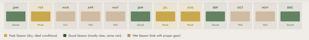
Primary Season: December – March (Recommended)
December through March is the most consistently dry and clear period on the Rwenzori. Reduced rainfall, lower cloud frequency on summit days, and better visibility on the high traverses make this period the optimal window for an 8-peak expedition. January and February, in particular, offer the highest probability of summit-day clarity across multiple peaks. Night temperatures at Margherita Camp are at their coldest (-12°C to -15°C possible), but daytime conditions can be exceptional. Book this period as early as 12 months in advance.
Secondary Season: June – August
June, July, and August provide another viable window, though weather patterns are less predictable than December–March. Clouds more frequently obscure summit views, and lower-section trails are muddier. However, a skilled guide team effectively manages these conditions, and many 8-peak completions have occurred in July and August. This window suits trekkers constrained by Northern Hemisphere summer leave schedules.
Wet Seasons: April–May & October–November
These are the Rwenzori’s heavy-rainfall months. A full 8-peak expedition in April, May, October, or November is not recommended for a first attempt; the combination of 18 consecutive days with high precipitation, poor summit-day visibility across multiple peaks, and extremely muddy traverse terrain significantly reduces the probability of completing all eight summits safely. Experienced repeat-visit mountaineers who understand the conditions may consider wet-season expeditions; all others should target December–March or June–August.
What’s Included & What’s Not Included
Included in the 18-Day Expedition Package
- All Uganda Wildlife Authority (UWA) park entry fees and permits for the full 17-night mountain stay
- Professional certified lead guide(s) UWA-registered, English-speaking, wilderness first-aid trained, summit-certified
- Assistant guides as required for group size and summit days
- Experienced Bakonzo porter team: 1 dedicated porter per trekker (20kg limit per porter)
- All mountain meals: hot breakfast, packed lunch, and three-course dinner daily across all 17 nights
- Accommodation in designated wooden mountain huts at all camps
- Full technical summit equipment: crampons, ice axes, climbing harnesses, helmets, fixed ropes all sized and maintained to standard
- Free use of rubber boots in all available sizes essential for Kilembe Trail bog sections
- Emergency oxygen supply carried by guides throughout
- First-aid kit, medical monitoring equipment, and emergency evacuation protocol
- 10% of expedition proceeds directed to supporting Bakonzo community programs, schools, orphanages, and community infrastructure
Not Included
- International airfares and Uganda visa fees
- Comprehensive travel insurance with high-altitude mountaineering and helicopter medical evacuation coverage is mandatory for this expedition
- Tips and gratuities for guides and porters
- Accommodation in Kasese before Day 1 and after Day 18
- Transfers to/from Kilembe trailhead from Kasese or Kampala (available as add-on)
- Personal trekking gear: sleeping bag (-15°C rated minimum for this expedition), thermal layers, waterproof shell, trekking poles
- Personal snacks, energy gels, electrolyte supplements for 18 days
- Alcoholic beverages and personal expenditure
- Travel vaccinations and any prescribed medication, including Diamox
Full Packing & Gear List for the 18-Day Rwenzori Expedition
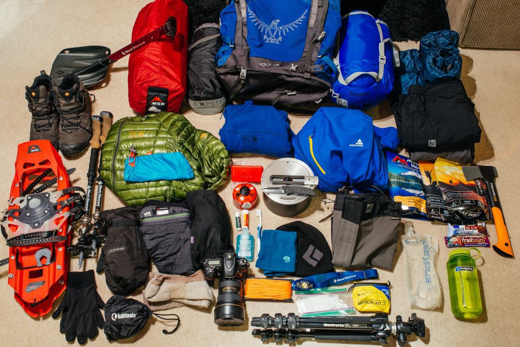
An 18-day expedition demands more and better gear than shorter treks. You will experience temperatures ranging from 30°C in Kasese to -15°C on summit nights. Every item must earn its place, and every system must work; there are no evacuation options for simply being cold or wet on Day 12. This is the definitive gear list for this expedition:
Footwear: Non-Negotiable
- Rubber boots (provided by RTS mandatory for all Kilembe Trail bog sections, fitted before departure)
- Neoprene socks: 2–3 pairs for warmth inside rubber boots on summit days
- Merino or thick wool hiking socks: minimum 5 pairs
- Lightweight camp shoes or sandals for hut use only
Sleeping System: Rated for Serious Cold
- Sleeping bag: minimum -15°C rating (not -10°C) C) Margherita Camp routinely reaches -12°C or colder with wind)
- Sleeping bag liner: silk or fleece; adds 3–5°C rating and extends bag life
- Inflatable sleeping mat or thin foam pad for under-sleeping-bag insulation from cold hut floors
Clothing: Layer System
- Base layer tops: 3 merino wool or synthetic moisture-wicking (NOT cotton)
- Base layer bottoms: 2
- Mid-layer: fleece jacket (200-weight minimum) OR down gilet (for layering under hardshell)
- Summit insulation: down jacket, minimum 700-fill, with hood the single most important item for summit days
- Hardshell jacket: fully waterproof, taped seams, Gore-Tex or equivalent non-negotiable
- Hardshell trousers: full zip-side for fitting over rubber boots non-negotiable
- Hiking trousers: 2 pairs (1 water-resistant-treated)
- T-shirts: 3 lightweight synthetic
- Balaclava: essential for -10°C summit nights; a hat alone is insufficient
- Warm hat: additional to balaclava
- Thin liner gloves: 2 pairs liner gloves get wet and must be rotated
- Waterproof insulated mittens: outer layer for summit day, no exceptions
- Neck gaiter or buff: 2
- Gaiters: optional but strongly recommended for bog sections with rubber boots
Technical Equipment: All Provided by RTS
- Crampons (fitted to your rubber boots at glacier approach on summit days)
- Ice axe (instruction provided at Margherita Camp evening briefing)
- Climbing harness
- Helmet
- Carabiners and slings (guide-managed)
- Rope (group equipment)
Pack & Carry
- Daypack: 30–40 litres larger than standard day treks, as summit days carry full summit kit
- Main bag: 60–80 litres for porters to carry (pack well; wet days happen)
- Dry bags / heavy-duty bin liners: critical for sleeping bag, electronics, and down insulation inside all bags
- Trekking poles: collapsible, with both rubber and spike tips
Health & Personal
- First-aid kit: comprehensive blister plasters (extensive supply), ibuprofen, paracetamol, antidiarrheal, rehydration sachets, wound closure strips, triangular bandage
- Diamox (acetazolamide): discuss with your doctor before the expedition; carry if prescribed; many serious mountaineers use it prophylactically
- Sunscreen SPF 50+: UV at 5,000m near the equator is extreme; reapply throughout every summit day
- Lip balm UV-protected: chapping at altitude is severe
- Hand sanitiser: 3+ small bottles for 18 days
- Blister prevention: toe socks, Leukotape, Compeed more than you think you need
- Eye protection: glacier glasses with side shields for Days 9 and 10 on Stanley Glacier (UV reflected ice is severe)
- All prescription medications: 20-day supply minimum
Electronics & Communication
- Headlamp: 2 units primary and backup, with lithium batteries (cold kills alkaline batteries)
- Power banks: 2 high-capacity units (no electricity for 17 nights)
- Camera: weatherproofed or in a weatherproof case
- Water bottles: 2 × 1-litre hard-sided + 1-litre hydration reservoir; 3 litres minimum daily capacity
- Water purification: SteriPen or tablets as primary; iodine as backup
- Personal trekking food: 18 days of snacks energy bars, gels, nuts, chocolate, dried fruit
- Emergency whistle and small mirror: lightweight safety essentials
- Cash (Ugandan shillings): for tips, have sufficient for guides and entire porter team for 18 days
Permits, Park Fees & Costs for the 18-Day Rwenzori Expedition
All trekking in Rwenzori Mountains National Park is regulated by the Uganda Wildlife Authority (UWA), which manages the park in partnership with Rwenzori Trekking Services (RTS). This system handles all fees, permits, guide certifications, and camp allocations. Rwenzori Trekking Safaris manages all park logistics on your behalf; you pay a single expedition price covering:
- UWA daily park entry fee × 17 days on the mountain
- Kilembe Trail concession fees and high-mountain traverse permits
- UWA-registered senior guide fee × 18 days
- Assistant guide fees for all summit days
- Mountain hut accommodation fees × 17 nights
- Technical equipment certification and maintenance fees
Porter wages are included in the package at fair rates structured through the Rwenzori Trekking Services operator agreement. Tips are your personal contribution and are distributed directly to your porter team at the end of the expedition. See our tipping guide for recommended amounts for the 18-day expedition.
Getting to the Rwenzori Mountains: Expedition Logistics
From Kampala to Kasese (~387 km, 5–6 hours)
The standard route is by private vehicle on the Kampala–Kasese highway via Fort Portal. Rwenzori Trekking Safaris arranges private 4WD transfers at an additional cost; public bus and shared taxi options are available but take 8–10 hours. Given the importance of Day 1’s rest and preparation, we recommend arriving in Kasese the evening before the expedition briefing to ensure full rest.
From Entebbe Airport (~430 km, 6–7 hours)
Arriving internationally, the full drive from Entebbe to Kasese is 6–7 hours via Kampala. We strongly recommend a night’s rest in Kampala or Entebbe on arrival before making the full drive west. Our team can arrange overnight accommodation and Day-1 transfer.
Kasese to Kilembe (12 km, 20 minutes)
The Kilembe trailhead (Trekkers Hostel) is 12 km from Kasese center along a tarmac road. Transfer is included in the expedition package.
Book Your Trek
Respond within Minutes
From
$4,050
per person
- Duration 18 Days / 17 Nights
- Group Size 1–12 people
- Start Point Kilembe TrailHead
- Departures Year-round
- Summits All Rwenzori Peaks
No booking fee. Free cancellation up to 30 days before departure. We respond within Minutes.
Our Popular Rwenzori Treks
Magheritah Peak (8 Days Kilembe Trail)
$1705 Per Person
Mutinda LookOut (4 Days)
$645 Per Person
Short Magherita Hike (5 Days Central Circuit)
$1200 Per Person
Rwenzori Hike (7 Days Central Circuit)
$1400 Per Person
Frequently Asked Questions: 18-Day Rwenzori All-Peaks Expedition.
What exactly are the 8 Rwenzori peaks summited on this expedition?
The 18-Day All-Peaks Expedition targets eight major summits across the Rwenzori’s six main massifs. These are Margherita Peak (5,109 m) on Mount Stanley, Africa’s third highest point; Alexandra Peak (5,083 m), also on Mount Stanley; Cheptegei Peak (~4,907 m) on the Stanley massif; Edward Peak (4,844 m) on Mount Baker; Vittorio Emanuele Peak (4,890 m) on Mount Speke; Umberto Peak (4,798 m) on Mount Emin; Bottego Peak (4,715 m) on Mount Gessi; and Weismann Peak (4,620 m) on Mount Luigi di Savoia. Combined, these summits cover every major Rwenzori massif and represent the complete mountaineering achievement of the range.
How difficult is the 18-Day Rwenzori All-Peaks Expedition compared to the 13-Day 6-Peaks trip?
The 18-Day expedition is substantially harder than the 13-Day 6-peak program in three respects: duration (5 additional days of cumulative effort), summit count (8 vs. 6, adding two extra summit-day exertions on top of already significant cumulative fatigue), and technical complexity (the inclusion of Alexandra Peak adds the expedition’s most demanding glacier traverse). The 18-day program also includes a more extensive traverse through the remote northern massifs, accessing Emin and Gessi via terrain that adds a route-finding challenge to the physical demand. The 13-Day 6-peak trip is already a serious mountaineering achievement; the 18-Day is the summit of what the Rwenzori offers.
Is the 18-Day Rwenzori Trek suitable for someone who has only climbed Kilimanjaro?
A single Kilimanjaro summit (non-technical) provides a baseline of high-altitude experience but is not sufficient preparation for the 18-Day Rwenzori All-Peaks Expedition. The Rwenzori’s technical glacier sections, sustained duration, and cumulative summit demands are categorically harder than Kilimanjaro’s nontechnical routes. We recommend progressing through the Rwenzori program, completing the 7-Day or 10-Day Kilembe Trek first to understand the terrain and your own high-altitude response before committing to the 18-Day program. Trekkers who have completed Kilimanjaro plus a technical Alpine or Himalayan trek (Everest Base Camp, Island Peak, Mont Blanc approach, etc.) are much better positioned.
What is the summit success rate on this 18-Day expedition?
Summit success rates on the 18-Day All-Peaks Expedition are highly variable because of the program’s extreme nature. All eight summits are weather-dependent and fitness-dependent every day; cumulative fatigue means that group members who summit all eight in peak season are genuinely performing at an expedition-level output. Our guides target 100% completion of all eight summits in favorable conditions, and most groups in the December–March window complete at least six of eight summits. The primary limiting factors are summit-day weather, altitude sickness, cumulative fatigue affecting performance on later summits, and the technical condition of the Stanley glaciers. We never compromise safety for summit completion; your guide’s decision is final on all summit attempts.
What travel insurance do I need for this expedition?
Travel insurance with explicit high-altitude mountaineering cover above 5,000 m and helicopter medical evacuation is mandatory for this expedition, not optional. Standard travel insurance does not cover these activities. You must purchase a specialized policy for adventure sports from a provider that specifically covers mountaineering to 5,200 m, emergency helicopter evacuation from remote terrain, and medical costs for altitude sickness treatment. Without appropriate cover, a helicopter evacuation from the upper Rwenzori can cost in excess of USD 10,000 out of pocket. Our travel insurance guide for the Rwenzori identifies appropriate providers.
How many guides and porters will I have on the 18-Day Expedition?
The 18-Day All-Peaks Expedition uses a higher guide ratio than shorter programs because of the technical complexity of multiple summit days. Typically, there is one certified senior lead guide for every 2–3 trekkers, along with assistant guides on all technical summit days and dedicated porters at a 1:1 ratio with trekkers. For a group of two trekkers, you may have 2–3 guides and 2 porters plus a mountain cook. For solo trekkers (private departures), a minimum of one senior guide and one assistant is mandatory. The total support team for a typical group of 4 trekkers on this expedition may exceed 10 mountain professionals.
Can the 18-Day expedition be shortened or extended?
The 18-day duration is the minimum required to attempt all eight peaks safely with adequate acclimatization and summit rest days. Compressing the itinerary below 18 days significantly increases altitude sickness risk and reduces the probability of completing all eight summits safely; we do not recommend it. Extension is possible: adding rest days at specific camps (particularly Butawu Camp pre-Baker or Margherita Camp pre-summit) benefits trekkers who are acclimatizing more slowly or want additional buffer for weather windows. Discuss your specific needs with our guides at booking.
What happens if a summit attempt fails due to weather or health on this expedition?
Weather-related summit failure on one or more days is built into the program as a realistic possibility over 18 days. Where possible, your guide team will adjust the schedule to attempt rescheduled summit windows within the remaining days. Health-related summit failures are handled by the immediate protocol: trekkers unable to summit safely descend with an assistant guide while other group members continue with the lead guide if fitness allows splitting. Any trekker who shows moderate to severe altitude sickness symptoms must descend immediately; there is no negotiation on this policy. The remaining group continues if it is safe to do so.
What phone signal and connectivity exists on the 18-Day route?
Phone signal on the Kilembe Trail above Sine Camp (2,596 m) is very limited and unreliable. MTN Uganda has the best coverage in the Kasese area but loses reliability above 3,000m. The traverse zones between massifs and the northern peaks area (Emin and Gessi) are effectively off-grid. For 18 days you should plan to be unreachable by phone on the mountain; inform family and emergency contacts before departure and give them the expedition’s itinerary with approximate camp locations. Our senior guides carry satellite communication devices for genuine emergencies.
Is the 18-Day Rwenzori Trek safe, and what is the emergency evacuation procedure?
The 18-Day Rwenzori All-Peaks Expedition is safe when conducted with a fully certified operator and followed by medically assessed, appropriately prepared trekkers. UWA certifies Rwenzori Trekking Safaris guides, trains them in wilderness first aid, provides emergency oxygen, and ensures they complete hundreds of summit expeditions. Altitude sickness, hypothermia, and falls on technical terrain pose the primary risks, which we manage through continuous monitoring, correct pace, proper equipment, and immediate descent protocols. You can evacuate from the mountain on foot (the fastest route out), supplemented by helicopter evacuation in severe cases.
How does the 18-Day All-Peaks trek compare to other African mountaineering challenges?
On the African continent, the 18-Day Rwenzori All-Peaks Expedition is comparable in ambition and complexity to a full technical ascent of Kilimanjaro’s Horcow or Western Breach route combined with multiple subsidiary peaks or a multi-peak expedition in the Ethiopian Simien Mountains or Bale Mountains. It surpasses all standard Rwenzori programs and stands alone as the range’s most comprehensive mountaineering itinerary. Internationally, it compares in duration and cumulative effort to hut-to-hut alpine routes in the Alps, though it has more remote terrain and less rescue infrastructure. The combination of technical glacier travel, sustained duration, multi-peak objectives, and the extraordinary botanical landscape is genuinely unique globally.
Ready to Attempt Africa’s Ultimate Mountaineering Expedition?
The 18-Day Rwenzori All-Peaks Expedition is the complete crown of the Mountains of the Moon.
Fewer than a few dozen mountaineers complete all eight peaks in any given year. Our expedition team has summited Margherita Peak over 200 times. We know every meter of this mountain.
This expedition requires honest conversation before booking.
- WhatsApp a senior mountain guide directly: +256 773 256 104
- Email: rwenzoritrekkingsafaris@gmail.com
- Request a detailed quote.
Honest assessment. Expert guidance. No shortcuts