What Is Notable About the Rwenzori Mountains? A Deep Dive into Africa’s Most Extraordinary Alpine Range
Discover the notable features of the Rwenzori Mountains, including their ancient geology, Africa’s last equatorial glaciers, UNESCO status, giant plants, and the world’s most remarkable trek.
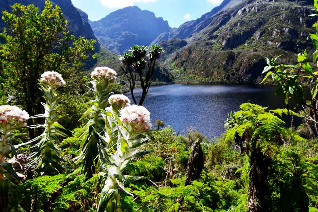
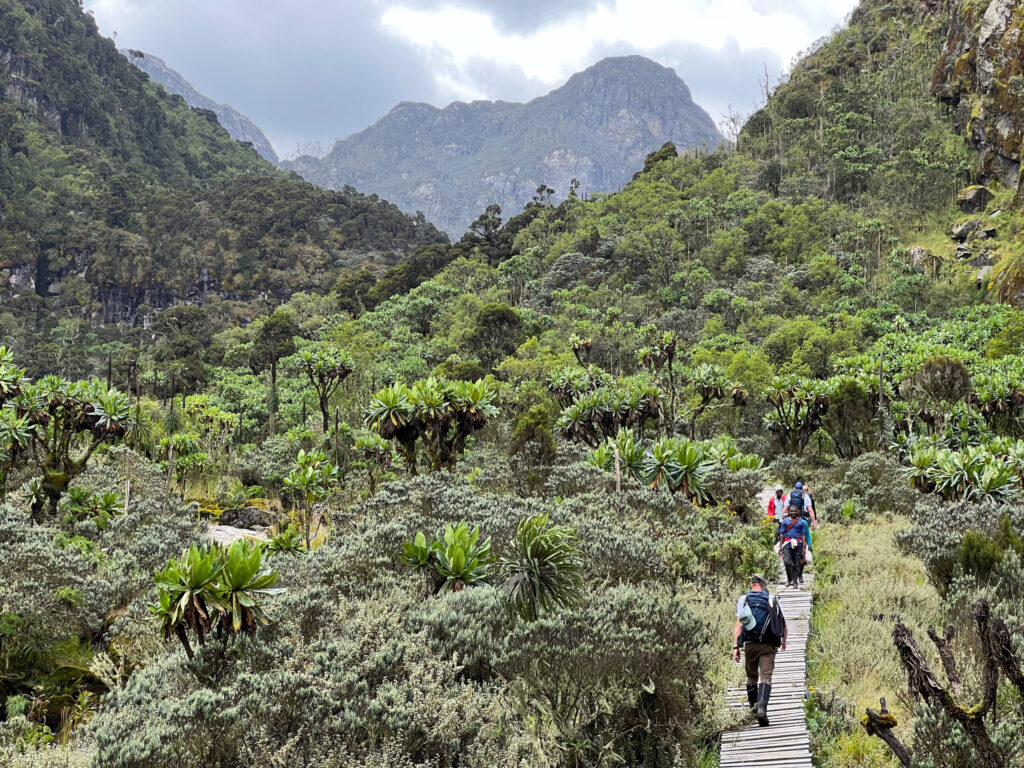
There is a moment on almost every Rwenzori trek, usually somewhere around Bugata Camp at 4,062 meters, when the last of the giant heathers has given way to open moorland and the giant lobelias are standing all around you in the morning mist where trekkers stop walking and just look. Not at any specific thing. Just at the landscape. And then they try to say something about it, and they cannot. Because the word “notable” doesn’t capture it. Neither does “remarkable” or “extraordinary” or any of the other superlatives that travel writers deploy. What the Rwenzori produces in that moment is something closer to quiet incomprehension. You are somewhere that does not obey the rules of any mountain you have ever been on before.
The Rwenzori Mountains: Notable Across Every Dimension That Matters
When people ask what is notable about the Rwenzori Mountains, they are usually asking a planning question: is this worth traveling a very long way to experience? The answer needs a real look at many different areas like geology, ecology, history, culture, weather, and personal experiences because the Rwenzori’s importance isn’t just based on one amazing thing. It is spread across all aspects of the mountain and its effects on those who spend time there. The Rwenzori Mountains of western Uganda are, by any serious assessment, the most multidimensionally notable mountain range in Africa, and this article makes that case across every dimension it deserves.
The Rwenzori is notable geologically because it is not a volcano; it is the only major high mountain in East Africa formed by tectonic uplift rather than volcanic activity, with Precambrian rock that is among the oldest exposed stone on the continent. It is notable climatologically because it is the wettest major mountain range in Africa, receiving over 2,500 millimeters of annual rainfall at mid-altitude and generating its own persistent weather system from the moisture it draws off the Congo basin. It is notable ecologically because its five vegetation zones, from tropical rainforest to equatorial glacier in a single unbroken vertical transect, constitute the most complete mountain ecosystem sequence in Africa, the defining quality that earned it UNESCO World Heritage status in 1994.
It is notable historically because it has been known in the written record since approximately 150 AD, when Ptolemy of Alexandria described equatorial snow mountains at the source of the Nile. It is notable for its glaciers, the last significant equatorial ice masses in central-west Africa, losing area at a documented rate that makes every current expedition a witness to one of the most important environmental processes of our time. It is notable for its plants, specifically the giant lobelias and giant groundsels of the Afroalpine zone that represent the most concentrated expression of Afroalpine gigantism on any African mountain. And it is notable for the quality of the trekking experience it offers: technically diverse, ecologically immersive, genuinely challenging, and consistently producing the most profound mountain encounters reported by trekkers who have walked multiple East African routes.
This article covers all of it. By the end, the question of whether the Rwenzori is notable enough to justify the expedition will have answered itself.
Notable Facts of the Rwenzori Mountains at a Glance
The table below provides a rapid-reference summary of the Rwenzori Mountains’ most notable characteristics across twelve dimensions, each explained in depth in the sections that follow.
Dimension
What Makes It Notable
Global Significance
Geology
A tectonic horst of Precambrian rock, not a volcano; among the oldest mountain rock in East Africa
The only major non-volcanic high mountain in the East African Rift system
Altitude
Margherita Peak, 5,109 m, is the 3rd highest in Africa; range holds 4 of Africa’s 7 highest peaks
A genuine world-class mountaineering objective on a guided expedition accessible to fit non-specialists
Glaciers
Last significant equatorial glaciers in Africa; ~80% of 1906 ice extent already lost
Among the world’s most documented examples of tropical glacier retreat; actively monitored by climate scientists
Vegetation
5 fully intact zones from rainforest (1,450m) to glacier (5,109m)
The most complete vertical ecosystem sequence of any African mountain; primary reason for UNESCO World Heritage status
Plant evolution
Giant lobelia (5m+), giant groundsel (3m+), 20m tree heathers, and Afroalpine gigantism
Convergent evolution uniquely concentrated in the Rwenzori; endemic species found nowhere else on Earth
One of the planet’s most important conservation areas per unit area
Watershed
Dual watershed rivers flow to both the Nile (east) and the Congo (west)
The only mountain in Africa that feeds both of the continent’s two greatest river systems
History
Referenced by Ptolemy c. 150 AD as source of the Nile; first ascent 1906 (Duke of Abruzzi)
Nearly 2,000 years of continuous geographical and historical significance
Name
“Mountains of the Moon” has been in use since at least Ptolemy’s Geographia (c. 150 AD)
One of the oldest surviving geographical names in Africa; appears in ancient Greek, medieval Arabic, and modern English
Conservation status
UNESCO World Heritage Site (1994); Ramsar Wetland (2008); National Park (1991)
Triple international designation recognising geological, ecological, and hydrological importance
Trekking character
The most technically diverse major trekking route in Africa, with 5 terrain types in 7–8 days
Consistently rated among the world’s most rewarding mountain expeditions by experienced guides
Scientific Records and Measurable Distinctions
Before going into the experiential and narrative dimensions of the Rwenzori’s notability, it is worth establishing the factual baseline: a set of measurable records and distinctions that place the range in its objective global and African context. The table below compiles these records with their sources.
Record or Distinction
Measurement/Context
Source/Authority
3rd highest peak in Africa
Margherita Peak: 5,109m
Universally recognised ranking
Highest point in Uganda
Margherita Peak: 5,109m
Uganda government/UWA
Highest point in the DRC
Margherita Peak: 5,109m
DRC government cartography
4 of Africa’s 7 highest peaks
Stanley (5,109m), Speke (4,890m), Baker (4,843m), Emin (4,798m)
African peak altitude rankings
Last equatorial glacier in central-west Africa
Stanley Glacier, Mount Stanley
International glaciological research
~80% glacier area loss since 1906
From Sella’s 1906 photography to current satellite imagery
Multiple peer-reviewed glaciology studies
Oldest geographical name in Africa (in continuous use)
“Lunae Montes,” Ptolemy c. 150 AD
History of cartography/geography
Annual rainfall at mid-altitude
Exceeds 2,500mm; summit zones receive considerably more
East African Meteorological Department
Distance from equator
33 km north
Geographical coordinates of the range
National park area
Approximately 1,000 km² within Uganda
Rwenzori Mountains National Park gazette
UNESCO designation year
1994 (World Heritage Site); 2008 (Ramsar Wetland)
UNESCO; Ramsar Convention
Albertine Rift endemic bird species
50+ species recorded within the park
African Bird Club; ornithological surveys
Notably Ancient: The Geology of a Mountain That Is Not a Volcano
A Tectonic Horst Among Volcanic Neighbours
The most fundamentally notable thing about the Rwenzori Mountains’ physical structure, which sets every subsequent ecological and historical distinction in motion, is that they are not volcanoes. This sounds like a simple negative, but its implications for everything about the mountain run very deep. The East African Rift system has produced an extraordinary series of volcanic mountains: Kilimanjaro, Mount Kenya, Mount Elgon, and the Virunga chain. These are young mountains in geological terms, formed by volcanic activity within the past few million years, with basaltic and andesitic rocks, fertile volcanic soils, and relatively simple geological structures.
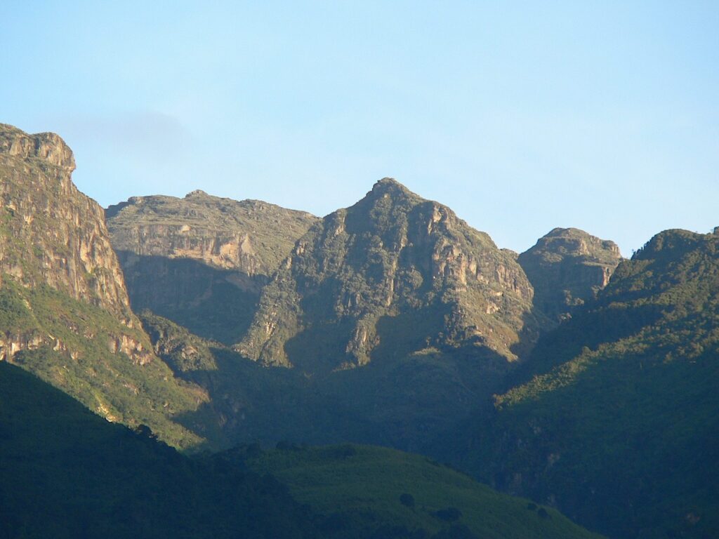
The Rwenzori is none of these things. It is a horst, a block of Precambrian basement rock elevated along fault lines by the tectonic forces of the Western Rift Valley. The rock that forms its core is ancient metamorphic gneiss and schist, created under immense heat and pressure during geological events that predate the formation of most of the current continents. Some of the exposed rock surfaces near the high camps and summit zone are among the oldest accessible geological formations in East Africa, and their deep time perspective of billions rather than millions of years gives the mountain a quality of permanence that its volcanic neighbors, for all their drama, cannot quite replicate.
The practical consequences of this non-volcanic origin are profound. The soils that have developed on Precambrian rock over millions of years are fundamentally different from volcanic soils, supporting different plant communities with different evolutionary histories. The mountain’s shape, a complex massif of interconnected ridges and deep valleys rather than a symmetrical cone, reflects the complex folding and faulting of its tectonic origin rather than the simpler geometry of volcanic construction. The Rwenzori’s sustained altitude, which has lasted far longer than that of its volcanic neighbors, has provided its endemic species with significantly more evolutionary time to diverge, resulting in the extraordinary botanical uniqueness that characterizes the high zones.
The Continental Divide
The Rwenzori’s tectonic position also provides it a geographical distinction that no other mountain in Africa shares: it sits astride the continental divide between the Nile drainage basin to the east and the Congo drainage basin to the west. Rain that falls on the mountain’s eastern slopes eventually reaches the Nile and the Mediterranean. Rain that falls on the western slopes eventually reaches the Congo River and the Atlantic. The Rwenzori Mountains play an important role in collecting water for two of Africa’s major river systems at the same time, which makes them essential for water conservation beyond their local area. This is one reason they were designated as a Ramsar Wetland site in 2008, highlighting their international importance for protecting water resources.
Notably Wet: The Climate of the Rainmaker
The Rwenzori Mountains are notable for their climate in a way that is simultaneously their most challenging characteristic and the engine of their greatest beauty. The Bakonjo people’s name for the mountain from which Stanley derived “Ruwenzori” in 1888 means approximately “rainmaker” or “cloud king,” a description that captures the mountain’s relationship with moisture more accurately than any meteorological measurement. The range sits at the convergence of two moisture systems: air masses moving inland from the Indian Ocean to the east and moist air from the Congo basin’s vast rainforest to the west. The Rwenzori’s mass deflects both systems upward, causing them to lose moisture as cloud and rain on the mountain’s slopes.
The result is a climate of extraordinary wetness and persistent cloud cover. Annual rainfall at mid-altitude stations within the park regularly exceeds 2,500 millimeters. The summit zone is in cloud for the majority of the year, and clear views of the glaciated peaks from the valley below are the exception rather than the rule in any season. Even in the dry seasons of June-August and December-February, the best windows for trekking in rain are possible and often probable on any given day. The Rwenzori does not have a dry season in the sense that most East African mountains do; it has a less-wet season, and the difference matters for planning but should not create false expectations of consistently fine weather.
This exceptional wetness is responsible for the cascade of ecological characteristics that make the Rwenzori notable. The extraordinary moss communities of the heather zone, some of the most species-rich and visually striking in any African mountain ecosystem, exist because of the constant moisture. The giant heather trees’ moss burial (their trunks and branches submerged under kilograms of old man’s beard lichen and multiple moss species) reflects a moisture regime that never allows the moss to dry out and retreat. Moisture directly supports all of the defining features of the Rwenzori landscape, including the glacial lakes of the high zones, the waterfalls that thread every valley on every trekking route, and the deep peat of the Bigo Bogs. The mountain’s climate does not merely frame its ecology; it produces it.
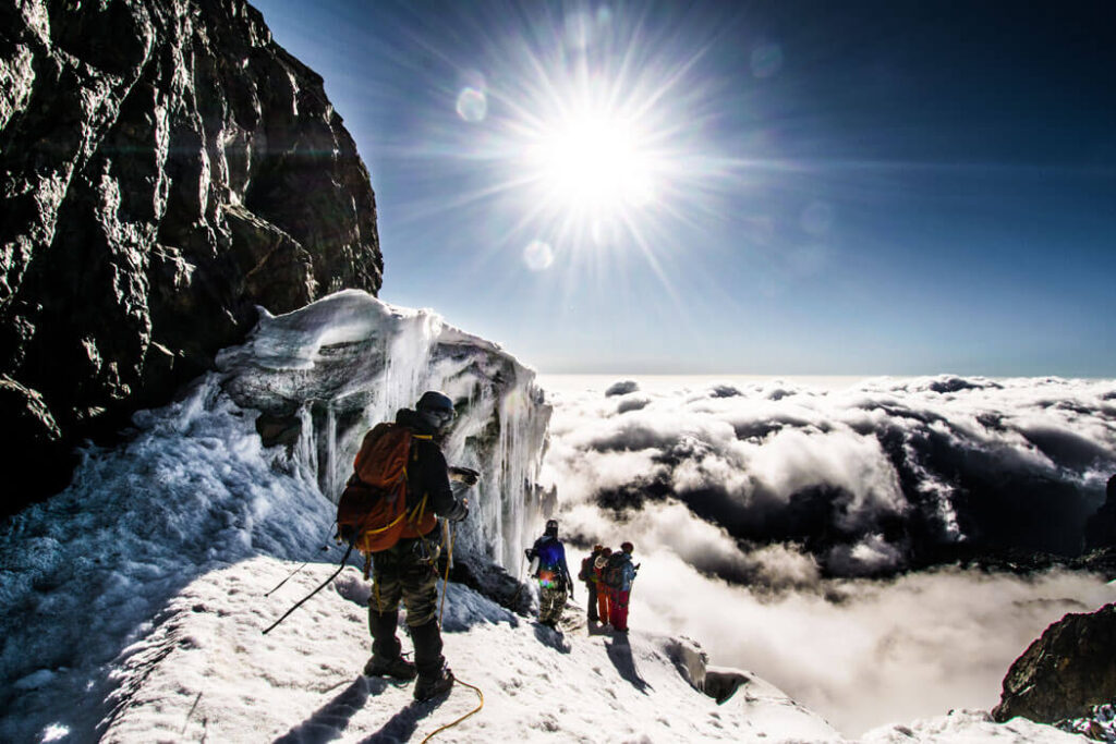
Notably Glaciated: Africa’s Last Equatorial Ice
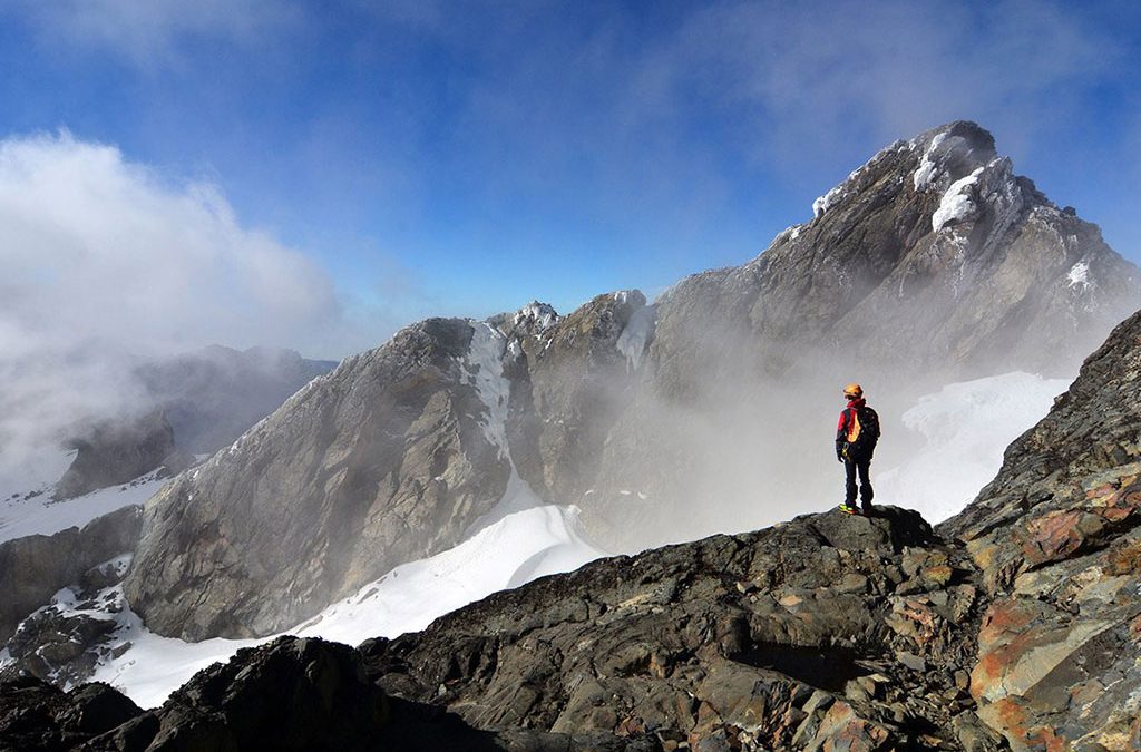
Among the scientifically notable features of the Rwenzori Mountains, none carries more weight in the twenty-first century than the presence of the last significant equatorial glaciers in central-west Africa. The Stanley Glacier on Mount Stanley is one of a tiny number of remaining ice masses within the tropics on the African continent, and its documented rate of retreat makes every current expedition a participant in one of the most important environmental processes of our era.
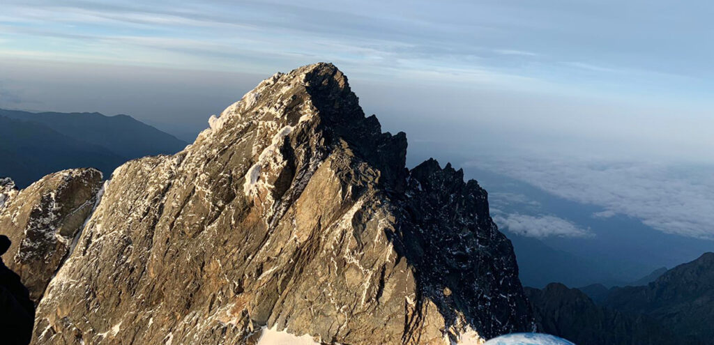
The comparison between Vittorio Sella’s meticulous 1906 photographs taken during the Duke of Abruzzi’s first ascent expedition and current satellite imagery tells a story that no climate model can make more vivid. The Stanley Glacier has retreated to a fraction of its original extent, having covered the broad upper plateau of Mount Stanley in 1906 with continuous ice sheets that extended well down the mountain’s flanks. Researchers estimating the total ice area loss since 1906 place it at approximately 80%, and the rate of loss has accelerated in the twenty-first century as global temperatures continue to rise. Published scientific assessments have suggested that without dramatic change in greenhouse gas emissions trajectories, the Rwenzori’s last ice may disappear entirely within decades.
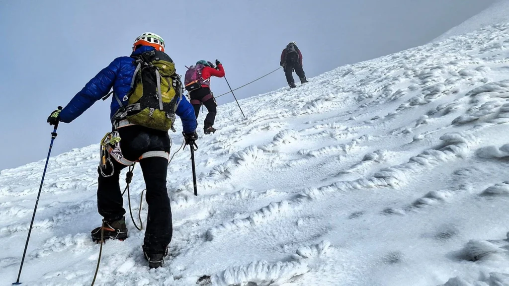
What makes this phenomenon notable beyond the immediate scientific significance is the experiential dimension for trekkers. The glacier section reached on the summit day after six or seven days of forest, heather, and Afroalpine trekking is technically different from what the Duke of Abruzzi’s party encountered in 1906. The ice that remains is steeper, more crevassed, and more demanding than the broad snowfields of the early photographs because the glacier has thinned, and the angle of the remaining ice has increased as the mass recedes. The Uganda Wildlife Authority has installed a glacier bridge and fixed climbing lines on the critical crevasse section, improving both safety and accessibility, but the summit remains a genuine glacier climb: crampons, ice axes, roped teams, and an early-morning start to reach the summit before afternoon cloud builds from the Congo. Standing on the ice at the equator, at 5,109 meters, with the Congo basin spreading away to the west below the cloud, the experience is still possible, still extraordinary, and noticeably less guaranteed with each passing decade.
The glacier that exists on Mount Stanley today is one of the last opportunities in Africa to experience glacier travel at the equator. Climate projections suggest this window is narrowing. The expedition a trekker takes to the Rwenzori in the next decade may not be available in the same form for the following generation.
Notably Biodiverse: An Albertine Rift Hotspot in Vertical Form
The Albertine Rift Biodiversity Significance
The Rwenzori Mountains sit at the northern end of the Albertine Rift, the western branch of the East African Rift Valley, running from the area of Lake Albert south to Lake Tanganyika, which is one of the most important biodiversity hotspots on the planet. The Albertine Rift contains higher densities of endemic vertebrate species than any other region of comparable area in Africa, and the Rwenzori Mountains contribute disproportionately to this richness because of their altitudinal range, their Ice Age refugium history, and their exceptional moisture regime.
More than fifty bird species endemic or near-endemic to the Albertine Rift have been recorded within Rwenzori Mountains National Park, making the range one of the premier birding destinations in Africa for birders specifically seeking Albertine Rift endemics. The Rwenzori turaco (Gallirex johnstoni), with its brilliant crimson wing patches visible in flight, is the most celebrated, but the list extends through the Rwenzori batis, the Rwenzori double-collared sunbird, the Rwenzori nightjar, the strange weaver, Archer’s robin-chat, the handsome francolin, and dozens of other species found in this restricted biogeographic zone. A serious birder can see more Albertine Rift endemics in a single week on the Rwenzori than in months of birding elsewhere in East Africa.
The mammal community is equally notable for its endemic character. L’Hoest’s monkey (Cercopithecus lhoesti) lives in the lower forest areas with black and is unique to the Albertine Rift, holding great cultural importance for the Bakonjo people. The Rwenzori red duiker (Cephalophus rubidus) is a small antelope found in mid-altitude forests and heather zones. The three-horned chameleon (Trioceros johnstoni) is one of the most photographed animals on the mountain, its prehistoric appearance and deliberately slow movement making it a reliable subject for the many trekkers who discover it crossing the trail on Day 1.
The Ice Age Refugium Legacy
The Rwenzori’s extraordinary biodiversity is not only a product of its current conditions; it is also a legacy of its Ice Age history. During the Last Glacial Maximum, when cooling and drying conditions caused the retreat of tropical forest across much of equatorial Africa, the Rwenzori’s persistent moisture regime allowed forest communities to survive within the mountain’s protective microclimate. The mountain functioned as a refugium: an island of suitable habitat in a changed landscape, within which forest-dependent species could persist while their counterparts in surrounding lowlands were being eliminated.
The consequence of this refugium history is that the Rwenzori’s forest communities carry a higher genetic diversity and a deeper evolutionary heritage than comparable forests that were more recently recolonized after the Ice Age ended. Species that were isolated within the Rwenzori refugium during the glacial period had time to diverge genetically from populations in other refugia, contributing to the high levels of endemism that characterize the Albertine Rift region today. This is not merely an academic context; it explains why the Rwenzori’s forests feel, to botanists and ecologists who study them, qualitatively different from other East African montane forests. They are, in a meaningful sense, older.
Notably Botanical: Plants That Rewire Your Understanding of What Plants Can Be
The Rwenzori’s botanical communities are, in the straightforward assessment of botanists and ecologists who have worked on the mountain, among the most scientifically notable in Africa. The range contains plant communities found nowhere else on Earth, demonstrating evolutionary processes such as Afroalpine gigantism, convergent adaptation, and extreme endemism, which are fundamental to our understanding of how life responds to isolation and altitude. For the trekker without specialist botanical training, none of this technical context is required to appreciate what the plants of the Rwenzori do: they produce a landscape that is genuinely unlike anything else in the world.
The giant lobelia (Lobelia wollastonii) and the giant groundsel (Senecio adnivalis and related Dendrosenecio species) of the Afroalpine Moorland Zone between 3,500 and 4,500 meters are the most celebrated expressions of Afroalpine gigantism, the tendency of certain plant groups to evolve dramatically oversized forms at high altitudes on equatorial mountains. The giant lobelia reaches four to five meters in height before sending up a single massive flowering spike and dying; the giant groundsel forms a tree-like structure with a branching trunk topped by cabbage-headed leaf rosettes that protect the growing tip from nightly frost. Both species demonstrate adaptations to the unique thermal environment of equatorial high mountains: the intense diurnal temperature swings that can drop from above zero to several degrees below freezing and back within a single twenty-four-hour period reward plants with high thermal mass, efficient insulation, and the ability to trap warmth internally.
The giant tree heather (Erica arborea) of the Heather-Rapanea Zone between 3,000 and 3,500 meters is the third pillar of the Rwenzori’s botanical notability. Growing to fifteen to twenty meters in height would be exceptional for any heather anywhere in the temperate or alpine world, and buried under deep communities of old man’s beard lichen (Usnea) and multiple moss species, the giant heather forest of the Rwenzori is one of the most visually distinctive mountain plant communities on Earth. Photographs consistently fail to convey the scale, the depth of the moss, and the atmospheric quality of moving through a forest where the light is filtered through meters of lichen and the sound of dripping water is constant. It has to be walked through in order to be understood.
Notably Protected: UNESCO, Ramsar, and the Triple Conservation Framework
The Rwenzori Mountains’ conservation status is notable for its layered comprehensiveness. The range holds three international designations: a national park (1991), a UNESCO World Heritage Site (1994), and a Ramsar Wetland of International Importance (2008), each recognizing a different dimension of its global significance and each carrying its own set of international obligations on the part of the Ugandan government.
The UNESCO World Heritage designation of 1994 is the most widely known and carries the most weight in international conservation and tourism contexts. The Rwenzori satisfied the UNESCO criteria for outstanding universal value across multiple grounds simultaneously, which is relatively uncommon among natural heritage nominations. The main reason for the designation was the remarkable health and full range of its natural ecosystems, especially the continuous stretch of five types of plant life from tropical rainforest to equatorial glacier. The designation also recognized the range’s outstanding natural beauty, its geological significance, and its importance as a habitat for globally threatened endemic species. In the same year, Bwindi Impenetrable Forest received an equivalent UNESCO designation, an unprecedented dual recognition of Uganda’s natural heritage in a single calendar year that signalled the country’s emergence as a globally significant conservation destination.
The Ramsar designation of 2008 addressed a different but equally important dimension of the Rwenzori’s significance: its role as a water tower. The rivers rising in the mountain’s glaciers and snowfields feed the Albert Nile to the east and the Semliki River system to the west, contributing to the water supply of millions of people across two drainage basins. Recognizing this hydrological function as a matter of international importance placed an additional conservation obligation on Uganda and established the Rwenzori’s water resources as globally protected infrastructure. For the trekker crossing the Kilembe Trail’s numerous stream bridges or hearing the permanent sound of water from every direction at the mountain camps, the Ramsar designation has an immediate and tangible meaning: this mountain is one of Africa’s most important freshwater sources, and the waterfalls you are walking beside are part of a hydrological system of continental significance.
Notably Historical: From Ptolemy’s Geography to the Duke of Abruzzi’s Camera
The Oldest Named Mountain in African Geography
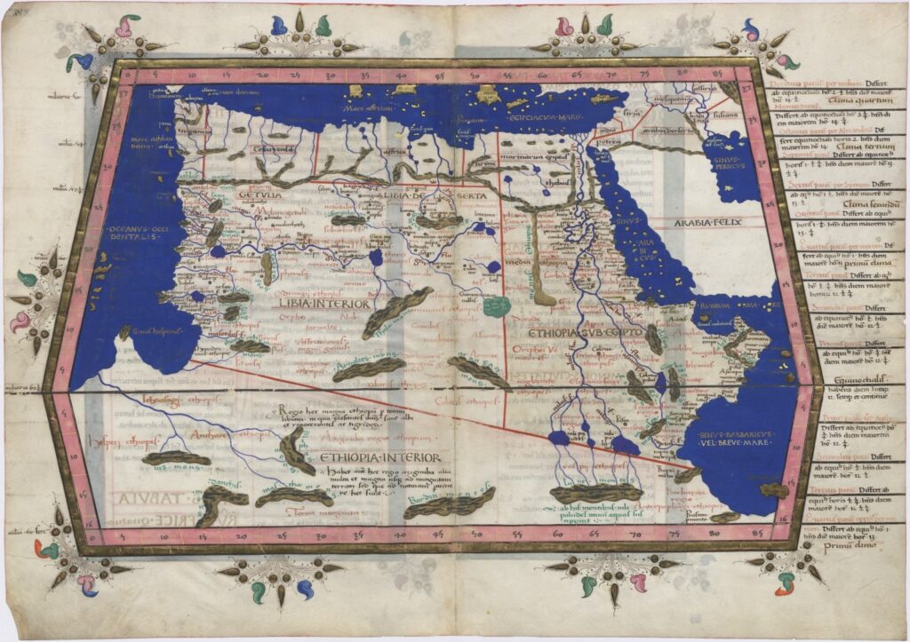
The historical notability of the Rwenzori Mountains is in a category of its own among East African ranges. The first written record of the mountain appears in Ptolemy’s Geographia of approximately 150 AD, nearly two thousand years ago, where the Greek geographer described equatorial snow mountains he called “Lunae Montes” (Mountains of the Moon) as the source of the Nile. The Arab geographical tradition preserved this reference through the medieval period, with al-Idrisi’s 1154 Tabula Rogeriana including the mountains in a world map that was the most comprehensive cartographic work of its time. European cartographers reproduced the feature on maps without direct observation for centuries, until Henry Morton Stanley’s 1888 confirmation finally placed the mountains on the map of confirmed knowledge.
Ptolemy’s Africa Map
This nearly two-thousand-year span of recorded human engagement provides the Rwenzori a historical depth that no other East African mountain approaches. Kilimanjaro was not formally confirmed by European observers until 1848. Mount Kenya until 1849. The Virunga volcanoes were not systematically described until the late nineteenth century. The Rwenzori was already ancient knowledge, a feature of the world’s most comprehensive geographical texts, referenced in multiple languages and cultural traditions when the first European ever set eyes on it. Standing on the Scott Elliott Pass on the Central Circuit Trail, a trekker is crossing a feature that appears in the geographical literature of the Islamic world in the twelfth century.
The Duke of Abruzzi’s 1906 Legacy
The mountaineering history of the Rwenzori is anchored by one expedition above all others: the 1906 journey led by Luigi Amadeo di Savoia, Duke of Abruzzi, which made the first ascents of all six major Rwenzori massifs, including Margherita Peak (5,109 m) on 18 June 1906. The Duke arrived not as an amateur adventurer but as one of the world’s most accomplished mountain explorers, already credited with the first ascent of Mount Saint Elias in Alaska (1897) and a polar latitude record of 86°34’N (1900). His Rwenzori expedition was systematic, scientifically rigorous, and comprehensively documented.
The expedition’s most enduring legacy for contemporary trekkers is the photographic record produced by Vittorio Sella, arguably the finest mountain photographer of the early twentieth century. Sella’s images of the Rwenzori’s glaciers in 1906 are now the primary before-and-after reference for measuring glacier retreat, and the comparison between his photographs and current conditions on Margherita Peak is among the most compelling visual documents of climate change on any mountain in the world. The Duke’s high camp, now known as Margherita Camp on the Kilembe Trail, still serves as a staging point for summit expeditions, connecting every modern ascent to the original 1906 journey through the same geographical logic.
Notably Human: The Bakonjo and Their Mountain
The Rwenzori Mountains are notable for a human story that deserves at least as much attention as the geological and ecological ones. The Bakonjo people, the Bantu-speaking indigenous community whose homeland encompasses the mountain’s foothills and lower slopes, have maintained a relationship with the Rwenzori across centuries that is simultaneously practical, spiritual, and cultural in dimensions that no European exploration narrative fully captures.
The Bakonjo name for the mountain, “Rwenzururu,” from which both “Ruwenzori” and “Rwenzori” are derived, means approximately “rainmaker” or “cloud king,” reflecting a profound understanding of the mountain’s role as the source of the water that sustains agricultural life in the surrounding valleys. The L’Hoest’s monkey inhabiting the lower forest zones is a cultural totem for many Bakonjo families, protected from hunting by traditional law in ways that parallel and predate the formal conservation regulations of the national park. The mountain is understood in Bakonjo cosmology as the home of ancestral spirits and a site of spiritual power, and the relationship between the community and the range is one of custodianship rather than domination.
The practical dimension of this relationship is equally notable. The Bakonjo porter and guide teams that supported every major European expedition on the Rwenzori from the Duke of Abruzzi’s 1906 journey onward were the professional predecessors of the guide and porter teams that operate on the mountain today. Their lived experience of daily engagement with a complex and demanding landscape transmits knowledge of the mountain’s trails, water sources, weather patterns, and ecological communities across generations, forming the practical foundation on which every guided expedition is built. A Bakonjo guide with twenty years on the Rwenzori knows things about the mountain that no trekker, however experienced, and no researcher, however thorough, can replicate without that living continuity of knowledge.
Both Rwenzori Mountaineering Services and Rwenzori Trekking Services are Bakonjo community enterprises, and Rwenzori Trekking Safaris directs a portion of all trek proceeds to local Bakonjo community projects. This isn’t just a charity effort added to a business; it’s a deep commitment to the people whose skills and hard work help others explore the mountain and whose cultural connection adds important meaning to the Rwenzori beyond just its rocks and nature.
Notably Demanding, Notably Rewarding: The Trekking Character of the Rwenzori
The Most Technically Diverse Trek in Africa
The Rwenzori Mountains are notable among trekking destinations for the sheer technical diversity of their terrain. During a typical seven- or eight-day hike on either the Central Circuit Trail or the Kilembe Trail, a trekker experiences five very different types of ground: the root-filled, leaf-covered forest floor in the lower areas; the steep, slippery bamboo paths; the soft, mossy ground in the giant heather zone where the trail feels more like a tunnel; the tussock fields and boardwalks in the Afroalpine moorland and bog areas; and the glacier sections near the summit, which require crampons, ice axes, and being tied together with a guide. No other single trekking route in Africa demands this range of terrain skills and physical adaptability across a comparable duration.
The route structure of the Rwenzori amplifies this diversity. The Kilembe Trail, officially launched in 2011 by Rwenzori Trekking Services, beginning and ending at Kilembe town, is widely considered the more scenically dramatic of the two main routes, traversing the spectacular Bamwanjara Pass panorama, the hidden valley of Hunwick’s Camp, the Scott Elliott Pass approach to Margherita Camp, and the remarkable descent via Oliver’s Pass through the Nyamwamba Valley. The Central Circuit Trail, the historically established northern loop from Nyakalengija, managed by Rwenzori Mountaineering Services, offers the classic Rwenzori experience, including the famous Bigo Bogs, the glacial Lake Bujuku, and the approach to Elena Hut beneath the north face of Mount Stanley. Neither route simply repeats the other; they are genuinely distinct journeys through the same extraordinary range.
What the Rwenzori Produces in Those Who Walk It
The notable thing about the Rwenzori’s trekking character is not just the objective difficulty; it is the cumulative effect of seven or eight days inside a landscape that changes completely every twenty-four hours. By Day 3, a trekker who entered the forest on Day 1 and transitioned through bamboo and heather on Day 2 is now standing in the open moorland above the treeline, among giant lobelias, with the high peaks visible for the first time. By Day 5, they are at Hunwick’s Camp with the Stanley Plateau glacier in direct sight above. By Day 6, they are at Margherita Camp, listening to their guide explain crampon technique. And by Day 7, they are descending from the third-highest summit in Africa through an Oliver’s Pass view of the Nyamwamba Valley that, of all the views on the mountain, is perhaps the least photographed and the most memorable.
This ecological, altitudinal, and emotional progression distinguishes the Rwenzori from destinations where the summit is the sole focus. The summit of Margherita Peak is extraordinary, but it is one chapter of a story that began in the forest at 1,450 meters and will not end until the last day’s descent through the Nyamwamba Valley waterfalls. The mountain teaches the attentive trekker, and its lessons are unique to it alone. No other mountain in Africa delivers this curriculum.
For trekkers who want to experience the Rwenzori without the summit commitment, the 4-day Mutinda Lookout trek, the 3-day Mahoma Loop, and the Bukulungu Wilderness Camping Trail all provide access to specific notable features of the mountain within shorter and less technically demanding itineraries. The summit expedition remains the definitive text for a complete understanding of the Rwenzori and its full significance.
The Rwenzori in Its African Context: What Other Mountains Cannot Offer
Understanding what is notable about the Rwenzori requires placing it in its African context, specifically in comparison with the other East African mountains that international trekkers typically consider when planning an expedition to the region. The comparison reveals not a matter of better or worse, but of fundamentally different aspects, and the differences illuminate what the Rwenzori uniquely offers.
Kilimanjaro is Africa’s highest mountain and the world’s most popular high-altitude trekking destination, receiving over 50,000 summit attempts annually. Its non-technical routes are accessible to any reasonably fit adult willing to acclimatize properly, and its summit at 5,895 meters is a genuine achievement by any measure. What Kilimanjaro does not offer is ecological depth: its vegetation zones are thinner and drier than the Rwenzori’s, its forest zones have been significantly impacted by adjacent agricultural development on the lower slopes, and its summit plateau is a lunar landscape of rock and ice without the botanical richness of the Rwenzori’s equivalent altitude zones. The Kilimanjaro experience is primarily about altitude; the Rwenzori experience is about everything altitude produces when combined with exceptional moisture, ancient rock, and millions of years of isolated evolution.
Mount Kenya offers genuine technical mountaineering on its harder routes and a compelling wildlife and botanical community on its lower slopes, but it lacks the Rwenzori’s depth of ecological integrity and the botanical spectacle of the giant lobelia and groundsel communities. The Virunga volcanoes offer gorilla trekking and dramatic volcanic scenery, but their maximum altitude is substantially below the Rwenzori’s, and their geological youth means their botanical communities lack the evolutionary depth of the Rwenzori’s endemic flora. Each of these mountains is notable in its own right. The Rwenzori is notable for being the mountain that completes the picture, offering what the others do not.
Notably Urgent: Why the Rwenzori Demands Attention Now
There is a dimension to the Rwenzori’s notability that is specific to this particular moment in history: the urgency of the glacier. Equatorial glaciers in Africa are disappearing. The Rwenzori’s Stanley Glacier, which has lost approximately 80% of its 1906 area, is on a documented trajectory that makes every current expedition a participant in a process of irreversible change. The ice that exists today on Mount Stanley is unlikely to exist in its current form or potentially at all within several decades. This is not a prediction requiring specialist geological training to understand. It is a simple extrapolation from measured data, and any guide who has worked the Rwenzori for more than a decade has personally observed the ice margin retreat.
This urgency does not make the Rwenzori lesser; it makes it more. The mountain that a trekker experiences today, with the glacier still present and still requiring crampons and ice axes and a 2:30 AM departure under headlamp light on the ice, is an experience of irreplaceable rarity. The person who comes now gets to see and touch and move through something that is genuinely one of the last of its kind in Africa. The person who defers the trip by a decade or two may find a different summit experience still extraordinary in its own way, but not the same. The window in which equatorial glacier climbing is possible in Africa is narrowing, and the Rwenzori is its last significant address.
Frequently Asked Questions: What Is Notable About the Rwenzori Mountains?
What is notable about the Rwenzori Mountains?
The Rwenzori Mountains of western Uganda are notable across multiple dimensions simultaneously. Geologically, they are the only major non-volcanic high mountain in East Africa, an ancient tectonic horst of Precambrian rock, fundamentally different in origin and character from volcanic neighbors like Kilimanjaro and the Virungas. They contain Africa’s third-highest peak (Margherita Peak, 5,109 m) and four of the continent’s seven highest summits. They host Africa’s last significant equatorial glaciers, which have lost approximately 80% of their 1906 area. Their five intact vegetation zones, from tropical rainforest at 1,450 meters to glaciated summit at 5,109 meters, constitute the most complete mountain ecosystem sequence in Africa, the quality that earned UNESCO World Heritage status in 1994. Their Afroalpine giant plants (giant lobelia, giant groundsel, and twenty-meter tree heathers) represent evolutionary uniqueness found nowhere else on Earth. They have been recorded in geographical literature since Ptolemy’s “Lunae Montes” of approximately 150 AD, demonstrating nearly two thousand years of continuous historical significance.
Why are the Rwenzori Mountains a UNESCO World Heritage Site?
The Rwenzori Mountains were designated a UNESCO World Heritage Site in 1994 primarily because of their outstanding natural ecosystems, specifically the intact, unbroken sequence of five vegetation zones from tropical rainforest to equatorial glacier and the extraordinary concentration of endemic and threatened species they contain. The UNESCO World Heritage Committee recognized the range’s outstanding universal value for its natural beauty, its importance as an example of ongoing ecological and evolutionary processes, and its significance as a habitat for globally threatened Albertine Rift endemic species. The giant lobelias, giant groundsels, and giant tree heathers of the Afroalpine and heather zones plants found nowhere else on Earth in this form and density were central to the biological case for designation. The Rwenzori also received a Ramsar Wetland of International Importance designation in 2008, recognizing its critical hydrological role as the source of rivers feeding both the Nile and Congo drainage systems.
What is the geological significance of the Rwenzori Mountains?
The Rwenzori Mountains are geologically significant in East Africa because they are a horst, a block of Precambrian basement rock elevated by tectonic forces, rather than a volcanic mountain like all other major high mountains in the region. The rock forming the Rwenzori’s core is ancient metamorphic gneiss and schist, some of the oldest exposed geological material in East Africa. This tectonic origin gives the mountain a fundamentally different shape (a complex massif of ridges and valleys rather than a symmetrical cone), different soils (ancient weathered metamorphics rather than young volcanic soils), and a much longer history of high altitude, giving its endemic species more evolutionary time to diverge. The mountain also occupies a unique position as Africa’s continental divide, with rivers on its eastern slopes draining to the Nile and rivers on its western slopes draining to the Congo, the only mountain on the continent that simultaneously feeds both of Africa’s two greatest river systems.
How notable are the Rwenzori Mountains compared to Kilimanjaro?
The Rwenzori Mountains and Kilimanjaro are notable in different ways rather than simply competing on the same dimensions. Kilimanjaro is Africa’s highest mountain (5,895 m vs. 5,109 m for Margherita Peak) and receives over 50,000 summit attempts annually, making it the most visited high mountain on the continent. The Rwenzori receives a fraction of that traffic and offers a far more remote and expedition-like experience. Kilimanjaro’s vegetation zones are thinner and drier, its forest zones more impacted by human activity, and its summit plateau more barren than the botanically extraordinary Rwenzori high zones. The Rwenzori requires glacier travel with crampons and ice axes for the summit, while most Kilimanjaro routes are non-technical. The Rwenzori’s biodiversity, particularly its Albertine Rift endemic species, is considerably richer. The Rwenzori is older geologically (tectonic, not volcanic) and has a longer recorded human history. Among experienced East African mountain guides, the Rwenzori is consistently rated as harder, more technically diverse, ecologically richer, and more deeply rewarding than Kilimanjaro.
What makes the Rwenzori Mountains an important biodiversity site?
The Rwenzori Mountains are one of Africa’s most important biodiversity sites for several interconnected reasons. They sit within the Albertine Rift, the western branch of the East African Rift Valley, which has the highest density of endemic vertebrate species of any comparable area in Africa. The mountain contributes disproportionately to this richness because its exceptional altitudinal range (1,450–5,109 m) creates multiple distinct habitat types within a compact area. Its Ice Age refugium history the mountain maintained forest communities during climatic periods when surrounding lowlands were losing forest cover has produced deep genetic diversity and high levels of endemism. Rwenzori Mountains National Park has recorded over 50 bird species that are either endemic or near-endemic to the Albertine Rift. Nowhere else on Earth can you find the endemic plant communities of the Afroalpine zone, including giant lobelias, giant groundsels, and their associated species. The mountain is classified as both a UNESCO World Heritage Site (for biodiversity significance) and a Ramsar Wetland (for hydrological importance).
What is the most notable feature of the Rwenzori Mountains for trekkers?
Trekkers who have completed Rwenzori expeditions most consistently identify three features as the most notable of the walking experience. First, the vegetation, specifically the giant heather forest (3,000–3,500 m) and the giant lobelia and groundsel communities of the Afroalpine zone (3,500–4,500 m), which produce landscapes of genuine botanical strangeness unlike anything on any other African mountain. Second, the completeness of the ecosystem sequence: no other mountain in Africa delivers five categorically different vegetation zones in a single ascent, and the transition between zones is abrupt, dramatic, and immediately recognizable. Third, the glacier section on summit day is the experience of moving on crampons at the equator, on ice that may not exist in its current form in the coming decades, at 5,109 meters. These three elements together the plants, the sequence, and the glacier constitute a mountain experience that experienced guides consistently describe as unlike any other in East Africa.
Is the Rwenzori Mountains range the source of the Nile?
The Rwenzori Mountains contribute to the water system that feeds the Nile, though describing them as the “source of the Nile” requires some qualification. The rivers rising in the Rwenzori’s eastern slopes, fed by the mountain’s exceptional rainfall and glacier meltwater, drain into Lake Edward and then, via the Semliki River, into Lake Albert, which connects to the Albert Nile and ultimately to the White Nile system. This contribution led Ptolemy, in approximately 150 AD, to describe equatorial snow mountains (almost certainly the Rwenzori) as the source of the Nile in his Geographia, a description that held its geographical mystery for nearly 1,700 years. Stanley’s 1888 confirmation of the mountains helped resolve the long-running Nile source debate, and the Rwenzori’s hydrological contribution to the Nile system is real and significant, though the primary source of the White Nile is conventionally identified as Lake Victoria rather than the Rwenzori specifically. The mountain is also notably the source of rivers feeding the Congo system to the west, making it unique as the only mountain in Africa that simultaneously contributes to both the Nile and Congo drainage basins.
What are the most notable peaks in the Rwenzori Mountains?
The Rwenzori Mountains contain six major massifs, each with multiple named peaks. The most notable are: Margherita Peak on Mount Stanley (5,109 m), the third-highest point in Africa and the highest in Uganda and the DRC, first summited by the Duke of Abruzzi’s expedition on 18 June 1906; Alexandra Peak on Mount Stanley (5,091 m), immediately adjacent to Margherita, named after Queen Alexandra of the United Kingdom; Vittorio Emanuele Peak on Mount Speke (4,890 m), named after King Victor Emmanuel III of Italy; Edward Peak on Mount Baker (4,843 m), named after King Edward VII of the United Kingdom; Umberto Peak on Mount Emin (4,798 m); Iolanda Peak on Mount Gessi (4,715 m); and Sella Peak on Mount Luigi di Savoia (4,627 m), named after the Duke of Abruzzi himself. All six massifs were first climbed by the Duke of Abruzzi’s 1906 expedition, a remarkable mountaineering achievement completed within a single two-month expedition to a previously unclimbed range.
ANY QUESTIONS?
If you need any clarification about a Rwenzori trek, contact one of our trekking experts to start planning your journey today.
A 10% percentage of your safari proceeds goes to supporting the local Bakonjo Communities (orphans, schools & homes)
Hi there, welcome. Need help planning a trek, safari, or adventure? Chat directly with a real expert and mountain guide for honest advice, clear answers, and practical recommendations. No guesswork, no pressure.