Rwenzori Mountains Map: Complete Guide to Routes, Trails, Peaks, and Aerial Views of the Mountains of the Moon
Explore the Rwenzori Mountains map, including all trekking routes, camp GPS coordinates, peak positions, elevation profiles, satellite views, and an aerial photography guide.
The Rwenzori Mountains do not reveal themselves easily. They are hidden behind clouds for most of the year, buried in forests for the first two kilometres of altitude, and understood fully only by those who have walked every ridge and crossed every pass. A good map of the Rwenzori is not just a planning tool; it is an act of orientation in one of the most complex mountain geographies in Africa. This guide gives you that orientation, whether you are sitting at a desk in London or standing at the Kilembe trailhead wondering what comes next.
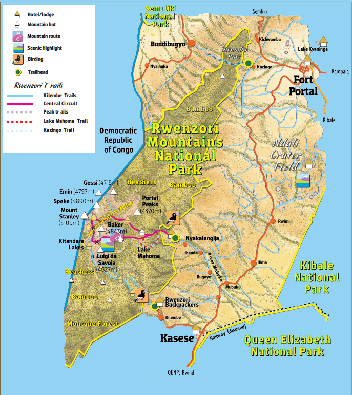
Understanding the Rwenzori Mountains: Geography and Position
The Rwenzori Mountains sit in western Uganda, straddling the border with the Democratic Republic of the Congo, approximately 33 kilometres north of the equator. They are not a volcanic range, unlike the Virunga volcanoes to the south or Mount Kilimanjaro to the east, but a horst, a block of ancient Precambrian rock thrust upward by tectonic forces to heights that exceed 5,100 metres. This geological origin provides the range its distinctive character: massive, complex, heavily glaciated at the summit, and draped in one of the most biodiverse sequences of mountain ecosystems in Africa.
The range runs roughly north to south for approximately 120 kilometres and east to west for 65 kilometres. The Rwenzori Mountains National Park protects approximately 1,000 square kilometres of terrain within Uganda; it was gazetted in 1991 and designated a UNESCO World Heritage Site in 1994. The DRC side of the mountain falls within Virunga National Park. From the air, from a commercial flight tracking the Entebbe-to-Kasese corridor on a rare clear morning, the Rwenzori appears as a sudden, dramatic spine of ice and rock rising from the flat plains of the Western Rift Valley: Lake Edward shimmering to the south, the Rift scarp falling away to the west, and the Rwenzori’s glaciated crown catching the early light in a way that makes every other feature of the landscape irrelevant.
Understanding where the mountain sits in relation to the nearest towns is essential for any trekker. Kasese, the district capital, lies immediately to the east of the southern end of the range, the gateway to the Kilembe Trail and the nearest supply point for both trails. Nyakalengija, the northern entry point for the Central Circuit, sits roughly 22 kilometres north of Kasese on the Kasese-Fort Portal road. The two trailheads are therefore on the same eastern face of the range, approximately 30 kilometres apart by road, but they access the mountain from fundamentally different directions and at different latitudes.
The Two Sides of the Rwenzori: North and South
One of the most important things a Rwenzori map reveals is that the mountain has two completely unique faces, and the two main trekking routes occupy them separately. The northern approach via the Central Circuit Trail from Nyakalengija enters the mountain through the Bujuku and Mubuku river valleys, penetrating the range from the northeast and ascending through the classic Central Circuit camp sequence to the high peaks. The southern approach via the Kilembe Trail from Kilembe enters from the south, ascending through the Nyamwamba Valley and its tributaries before reaching the same high peaks from the opposite direction.
Both routes converge in the high zone, where the Central Circuit Trail and the Kilembe Trail share the summit section of Mount Stanley. Elena Hut and Margherita Camp are within two to three kilometres of each other in the high zone. But the lower approaches are entirely separate, with different camp infrastructure, different management authorities, and entirely different terrain character. A map that shows both routes simultaneously makes this division immediately clear.
The northern Bujuku valley, accessed from Nyakalengija, is characterised by the famous Bigo Bogs, a vast peat bog system that has been made navigable by boardwalks, and the glacial Lake Bujuku beneath the north face of Mount Stanley. The southern Nyamwamba and Namusangi valleys, accessed from Kilembe, are characterised by dramatic waterfalls, the giant heather forest in the Mutinda zone, and the sweeping Bamwanjara Pass panorama. These are not alternative approaches to the same terrain; they are different terrains that happen to share a summit.
The Six Major Rwenzori Peaks: Positions and Altitudes
The Rwenzori Mountains contain six major mountain massifs, each carrying multiple named peaks and all exceeding 4,600 metres above sea level. Planning a Rwenzori expedition requires understanding the spatial relationship between the routes and the peaks. The table below gives the position, altitude, and approximate GPS coordinates of each massif’s highest peak.
Mountain
Highest Peak
Altitude
Position in Range
GPS (approx.)
Mount Stanley
Margherita Peak
5,109 m
Central massif, Uganda/DRC border
0°22′N 29°52′E
Mount Stanley
Alexandra Peak
5,091 m
Central massif, just below Margherita
0°22′N 29°52′E
Mount Speke
Vittorio Emanuele
4,890 m
North-east of Stanley
0°23′N 29°54′E
Mount Baker
Edward Peak
4,843 m
West-southwest of Stanley
0°21′N 29°51′E
Mount Emin
Umberto Peak
4,798 m
Northern end of range
0°28′N 29°51′E
Mount Gessi
Iolanda Peak
4,715 m
North of Emin
0°26′N 29°52′E
Mount Luigi di Savoia
Sella Peak
4,627 m
Southern end of range
0°19′N 29°51′E
Portal Peaks
Unnamed highest
4,627 m
North-western approaches
0°29′N 29°54′E
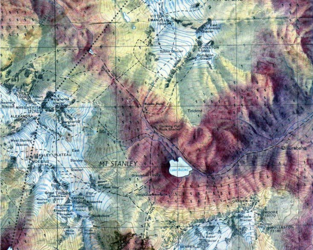
Mount Stanley: The Dominant Mass.
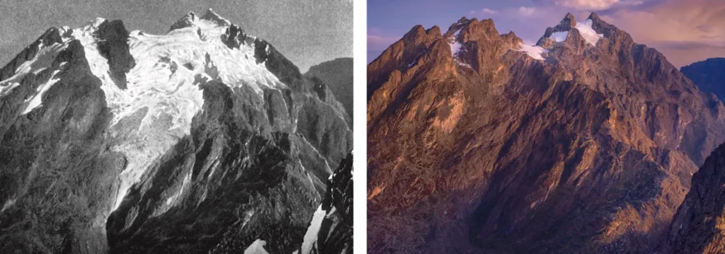
Mount Stanley is the largest and highest massif in Rwenzori, a sprawling complex of glaciated ridges and peaks centred on the Uganda-DRC border. Its highest point is Margherita Peak at 5,109 metres, followed by Alexandra Peak at 5,091 metres, Savoia Peak at 4,977 metres, Elena Peak at 4,968 metres, Moebius Peak at 4,906 metres, and Philip Peak at 4,742 metres. From above, Mount Stanley’s summit area appears as a broad, heavily glaciated plateau, the Stanley Plateau, from which multiple peaks project at the edges. The Stanley Glacier, which occupies this plateau, has retreated dramatically over the past century and is now a fraction of the size mapped by the Duke of Abruzzi in 1906.
Mount Speke, Mount Baker, and the Supporting Peaks
Immediately northeast of Stanley, Mount Speke (4,890 m at Vittorio Emanuele Peak) rises above the Bujuku Valley and is most naturally approached from the Central Circuit via Bujuku Hut. Its western face drops steeply toward the Stanley Plateau, making it visible from both Elena Hut and Margherita Camp on a clear day. Mount Baker (4,843 m at Edward Peak) sits to the west-southwest of Stanley, visible from Bamwanjara Pass on the Kilembe Trail and from the Kitandara Lakes below it. Its approach via Freshfield Pass on the Central Circuit descent is one of the most scenic sections of the northern route.
Further north, Mount Emin (4,798 m) and Mount Gessi (4,715 m) occupy the northern section of the range, accessible via extended multi-peak expeditions on the Central Circuit. At the southern end, Mount Luigi di Savoia (4,627 m at Sella Peak) is named after the Italian Duke of Abruzzi himself, Luigi Amadeo of Savoia, who led the first comprehensive mapping and climbing expedition to the Rwenzori in 1906.
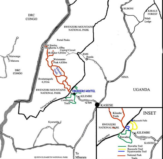
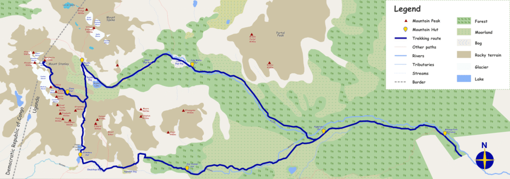
The Trekking Route Maps Explained
Central Circuit Trail Map: The 7-Day Northern Loop
The Central Circuit Trail describes a roughly circular route when viewed on a map, beginning and ending at Nyakalengija on the northeastern edge of the range. The trail enters the mountain and moves south-west, following the Mubuku River valley before climbing to Nyabitaba Hut on a forested ridge above the river confluence. From Nyabitaba, the route turns south-west again, crossing the Kurt Shafer Bridge at the junction of the Bujuku and Mubuku rivers before ascending through montane forest and bamboo to John Matte Hut.
The third and fourth days carry the route southwest and then west, into the upper Bujuku Valley and the famous Bigo Bogs before arriving at Bujuku Hut beneath the north face of Mount Stanley. The Scott-Elliot Pass, at 4,372 meters, connects the Bujuku Valley to Elena Hut on the southwest flank of Stanley, where the summit camp is positioned. After the summit and descent to Kitandara Lakes, the route turns southeast via Freshfield Pass (4,282m), descending into the Mubuku valley at Guy Yeoman Hut before the final northeast return to Nyakalengija. On a map, the trail traces a satisfying elongated loop through the heart of the range.
Kilembe Trail Map: The 8-Day Southern Circuit
The Kilembe Trail appears on a map as a loop of entirely different characters entering the mountain from the south at Kilembe (1,450 m), ascending in a broadly northward direction through the Nyamwamba Valley and its tributaries, crossing the mountain’s interior via Bamwanjara Pass and Scott Elliott’s Pass, and descending back south via the completely different Oliver’s Pass (4,505 m) and the Nyamwamba Valley’s western arm. The entry and exit points are in the same town, Kilembe, but the two valley systems used for ascent and descent are separated by several kilometres of mountainous terrain.
Viewed from above, the Kilembe Trail’s route forms a teardrop shape: narrow at the bottom where the trail approaches from Kilembe, widening as it ascends through Sine, Kalalama, and Mutinda Camps into the broader mountain interior, reaching its widest point in the Bamwanjara Pass and Hunwick’s Camp region where the route curves around toward the Stanley Plateau approach, then narrowing again on the Oliver’s Pass descent before returning to Kilembe. The camp positions – Sine at 2,596 m, Mutinda at 3,588 m, Bugata at 4,062 m, Hunwick’s at 3,974 m, and Margherita Camp at 4,485 m – trace an altitude profile that rises steadily before the dramatic summit day ascent to 5,109 m.
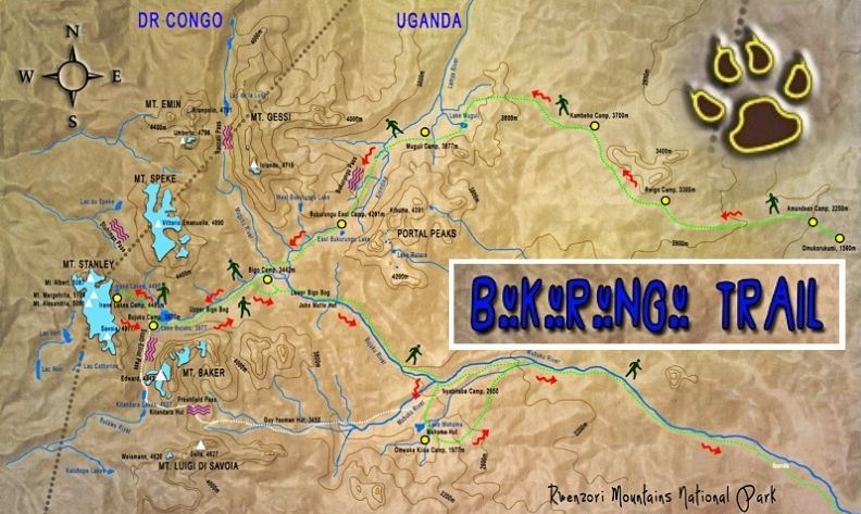
Bukurungu Wilderness Trail Map: The Western Approach
The Bukurungu Trail occupies the western approaches to the range, entering from the Kasanzi Park gate (Omukorukumi) in the northwest and traversing eastward between the Portal Peaks and Mount Gessi before connecting with the Central Circuit at the Bigo Bogs in the mountain’s interior. On a map, it appears as a broadly diagonal line cutting across the range from northwest to southeast, passing four alpine lakes, Irene, Mughuli, Bukulungu, and Bujuku, in sequence. Because it is an open-air camping trail (no permanent huts), its campsites appear on maps as temporary positions rather than fixed waypoints.
Mahoma Loop Map: The Northern Lower Circuit
The Mahoma Loop is the smallest circuit on the Rwenzori map, beginning at Nyakalengija and looping through the western lower slopes of the northern range to Lake Mahoma (approximately 3,515 m) via Kyambogho Ridge and the Mubuku Valley, before returning via the Nyabitaba Ranger Post and Mpanga Ridge. On a map it appears as a tight loop on the northeastern edge of the national park, completely within the lower forest and mid-altitude heather zones. Its geographical footprint is modest compared to the full summit routes, but its ecological richness, Lake Mahoma’s crater-lake setting, the bamboo and heather forests, and the primate habitats make it one of the most rewarding small-scale mountain circuits in Uganda.
Rwenzori Mountains Camp Reference: Altitudes, Distances, and GPS Coordinates
The table below is a comprehensive reference for every major camp and waypoint on the Central Circuit Trail and the Kilembe Trail, with approximate GPS coordinates, altitudes, and distances from the previous camp. This data is invaluable for trekkers loading route data onto GPS devices, for guide teams managing logistics, and for researchers and travel writers seeking precise geographical information about the range.
Trail
Camp/Waypoint
Altitude
Distance from Prev.
GPS (approx.)
Central Circuit
Nyakalengija / Mihunga Gate
1,646 m
Trailhead
0°22′N 30°00′E
Central Circuit
Nyabitaba Hut
2,651 m
~8 km
0°23′N 29°57′E
Central Circuit
John Matte Hut
3,380 m
~11 km
0°23′N 29°55′E
Central Circuit
Bujuku Hut
3,960 m
~5 km
0°22′N 29°54′E
Central Circuit
Elena Hut
4,541 m
~4 km
0°22′N 29°52′E
Central Circuit
Kitandara Hut
4,023 m
~4 km
0°20′N 29°52′E
Central Circuit
Guy Yeoman Hut
3,505 m
~6 km
0°21′N 29°54′E
Kilembe Trail
Kilembe Trailhead
1,450 m
Trailhead
0°10′N 30°02′E
Kilembe Trail
Sine Camp
2,596 m
~9.5 km
0°13′N 29°59′E
Kilembe Trail
Kalalama Camp
3,147 m
~5.5 km
0°15′N 29°57′E
Kilembe Trail
Mutinda Camp
3,588 m
~4 km
0°16′N 29°56′E
Kilembe Trail
Bugata Camp
4,062 m
~5 km
0°18′N 29°55′E
Kilembe Trail
Hunwick’s Camp
3,974 m
~6 km (via Bamwanjara Pass 4,450m)
0°20′N 29°53′E
Kilembe Trail
Margherita Camp
4,485 m
~5 km
0°22′N 29°52′E
Kilembe Trail
Margherita Peak (Summit)
5,109 m
~2.5 km
0°22′N 29°52′E
Kilembe Trail
Oliver’s Pass
4,505 m
Descent route
0°21′N 29°54′E
Kilembe Trail
Kiharo Camp
3,460 m
~7 km
0°18′N 29°57′E
Note: GPS coordinates are approximate, based on publicly available cartographic data. Trekkers should treat all listed coordinates as orientational rather than precision-navigation figures. Your guide team carries current GPS data and detailed printed maps for all route sections.
Aerial and Satellite Views of the Rwenzori Mountains.
What the Mountain Looks Like from the Air
The Rwenzori Mountains are immediately distinctive when viewed from a commercial aircraft flying at altitude in Uganda’s airspace, from a drone 500 meters above the treeline, or from satellite imagery. Unlike the volcanic cones of Kilimanjaro or the Virungas, which present clean geometric profiles against the sky, the Rwenzori is a massif: a sprawling, irregular block of interconnected ridges and valleys that rises from the surrounding plains without the symmetry of volcanic construction. The glaciated summit zone of Mount Stanley is visible in satellite imagery as a bright white patch against the dark green of the lower slopes, smaller than it was in historical photographs but still unmistakably present.
The two entry valleys, the Nyamwamba/Namusangi system from the south (Kilembe Trail) and the Bujuku/Mubuku system from the north (Central Circuit), are both visible in aerial imagery as dark, vegetated clefts in the mountain’s eastern face. The Kilembe Valley opens immediately north of Kasese town; the Mubuku Valley is the longer, more northerly entry that leads to Nyakalengija. From directly above, the paths of both routes can be traced through the forest canopy on high-resolution satellite images, though the vegetation density makes the trails themselves invisible at most zoom levels.
The Glacier Retreat: Reading Change from Above
Aerial and satellite imagery of the Rwenzori tells a story of rapid environmental change that every trekker should understand before visiting. The Stanley Glacier, which covered the entire upper plateau of Mount Stanley when the Duke of Abruzzi mapped and photographed it in 1906, has retreated to a fraction of its original extent. Research published by institutions tracking East African glaciers suggests the Rwenzori may lose its last ice within decades. Comparing historical aerial photographs from the 1950s with current satellite imagery shows the retreat in unmistakable terms: the ice margin has moved hundreds of metres down the mountain, and features that were ice-covered within living memory are now exposed rock.
This context is relevant for trekkers because the glacier retreat has changed the character of the summit section. Where earlier expeditions crossed broad, gently angled snowfields, today’s trekkers encounter steeper ice sections with more exposed rock at the margins. The Uganda Wildlife Authority’s installation of a fixed glacier bridge and climbing lines addresses these issues directly, but the underlying reality that the ice is steeper and smaller than it was means that summit day demands more technical attention than it did two decades ago. Satellite imagery makes this progression visible and accessible to anyone with a Google Earth account.
The View from Margherita: Summit Geography
The aerial view from the summit of Margherita Peak, at 5,109 meters, is extraordinary. The Stanley Plateau Glacier spreads below the remaining ice, visible as a series of crevassed fields between rocky ridges. To the west, the DRC’s Congo Basin drops away in an unbroken green canopy that stretches beyond the visible horizon. To the northeast, the summit of Mount Speke is clearly visible from Margherita; on a clear morning, its Vittorio Emanuele Peak is separated from the Stanley massif by the deep Bujuku valley below. Lake Bujuku is visible as a dark ellipse in that valley floor. Directly below to the south, the Nyamwamba Valley, the Kilembe Trail’s descent route, falls away through increasingly dense vegetation toward the Kasese plain. The experience of the summit is partly geographical: standing at the apex of a mountain system whose full extent becomes comprehensible only from this height.
The Rwenzori’s Vertical World: Reading the Vegetation Zone Map
One of the most useful planning tools for any Rwenzori trekker and one of the most distinctive features of the range’s cartography is the vegetation zone map: a vertical diagram showing the altitude bands of the mountain’s five ecological zones. Unlike the horizontal maps that show route geography, the vegetation zone diagram shows the Rwenzori as a vertical landscape, with the transition between zones indicated by altitude thresholds that carry practical implications for what each day of a trek will look and feel like.
The five zones, reading upward from the valley floor, are as follows. The Afro-Montane Forest Zone occupies the lowest levels, from approximately 1,450 to 2,600 metres; this is the first zone entered on both the Kilembe Trail (Day 1) and the Central Circuit (Day 1 to early Day 2). It is warm, humid, and dense with Podocarpus, Prunus africana, and figs, inhabited by colobus, L’Hoest’s monkey, Rwenzori turaco, and three-horned chameleons. The Bamboo-Mimulopsis Zone provides a brief but distinctive band between approximately 2,600 and 3,000 meters that is dense, steep, and, in the wet season, deeply muddy. The Heather-Rapanea Zone, ranging from approximately 3,000 to 3,500 meters, is the mountain’s most visually distinctive zone: giant tree heather buried in old men’s beard lichen, creating a landscape that looks unlike any other mountain ecosystem in Africa.
Above the heather, the Afroalpine Zone occupies the broad band from 3,500 to approximately 4,500 metres. This is the zone of giant lobelias and giant senecios, the signature botanical communities of the UNESCO World Heritage Site, products of millions of years of isolated evolution. The Bamwanjara Pass, Bugata Camp, Hunwick’s Camp, Kitandara Lakes, and Elena Hut all sit within this zone. Finally, the Nival Zone’s snow, ice, and bare rock begins above approximately 4,500 meters and includes the summit glaciers and the approaches to Margherita Peak. On a practical level, this map tells trekkers exactly what environment they will be walking through on each day of their itinerary.
How to Use Rwenzori Mountain Maps for Trip Planning
Choosing Your Route Using the Map
In the planning stages, the most useful function of a good Rwenzori route map is to help you visualise the fundamental differences between the two main trails. The Central Circuit enters and exits the same point on the northeastern side of Nyakalengija in a loop that curves through the mountain’s interior. The Kilembe Trail enters and exits the same point on the southern side of Kilembe in a different loop that approaches the high peaks from the south. Seeing these two routes on the same map makes it immediately clear that they are not alternative approaches to the same path but genuinely separate mountain journeys with different geographical characters.
The elevation profile map then adds the next layer of planning intelligence: the Kilembe Trail’s ascent profile is steeper in the lower sections, gaining significant altitude in the first three days before the gradual approach to the summit zone. The Central Circuit’s profile is more graduated over the first three days but includes the Bigo Bogs terrain challenge that adds physical effort beyond the simple altitude numbers. Both profiles show the summit day’s dramatic gain from the staging camp to 5,109 metres, a visual jolt in any elevation chart that clearly communicates what Day 6 (Kilembe) or Day 5 (Central Circuit) will require.
GPS and Navigation in the Field
All guided Rwenzori treks are led by certified guides, who are intimately familiar with every meter of their respective routes. Trekkers do not need to navigate independently on either the Kilembe Trail or the Central Circuit. However, many experienced trekkers choose to carry a GPS device or use an offline mapping app (Gaia GPS, ViewRanger, or AllTrails with downloaded offline maps) for personal reference and track recording. The GPS coordinate reference table in this article provides the starting data for loading waypoints manually. For the most accurate and current GPS tracks, your guide team’s pre-loaded device should be treated as the authority, as trail conditions and minor route adjustments happen seasonally.
Understanding Altitude from the Map
The single most practically useful information a Rwenzori map conveys for trip planning is altitude, not as a number to be impressed by, but as a physiological reality to be planned around. The altitude sequence of the camp determines the acclimatisation profile of your trip. The standard Kilembe Trail itinerary, Sine Camp (2,596 m), Mutinda (3,588 m), Bugata (4,062 m), Hunwick’s (3,974 m), Margherita Camp (4,485 m), and the summit (5,109 m), is designed to give the body a measured, step-by-step altitude progression that maximises acclimatisation while minimising altitude sickness risk. Trekkers who see this sequence on a map and try to compress it, skipping camps and combining days, should understand that they are not saving time; they are removing physiological preparation and materially increasing altitude risk.
The History of Rwenzori Cartography: From Ptolemy to Satellite
The Rwenzori Mountains have a cartographic history that stretches back further than almost any mountain range in Africa. Ptolemy of Alexandria, writing in the 2nd century AD, described “Lunae Montes”, the Mountains of the Moon, as the source of the Nile in his Geography. Historians debate whether Ptolemy specifically referred to the Rwenzori or to a broader concept of equatorial highland, but this identification has endured for nearly two millennia, giving the Rwenzori one of the oldest map citations of any mountain range on Earth.
The modern cartographic era of the Rwenzori began with Henry Morton Stanley’s 1889 expedition, during which he became the first European to observe and name the range, calling the highest peak after himself and naming Mount Speke and Mount Baker after fellow explorers. The first serious attempt at scientific mapping came with the Duke of Abruzzi’s 1906 expedition, which produced detailed topographic surveys, glacier extent measurements, and the first photographic documentation of the high peaks. Those 1906 photographs, compared with current satellite imagery, provide some of the most compelling evidence of glacier retreat in equatorial Africa.
Subsequent decades brought aerial survey mapping by the British colonial administration, refined topographic sheets by the Uganda Survey Department, and eventually the GPS-enabled digital mapping that underpins today’s navigation technology. The Rwenzori’s complex topography, deep valleys, densely vegetated slopes, and frequent cloud cover made aerial photogrammetry challenging, and the mountain’s maps have historically been less precise than those of more accessible East African peaks. Modern satellite technology has largely resolved these issues and the current generation of satellite-derived digital elevation models gives a level of topographic detail that the Duke of Abruzzi’s surveyors could not have imagined.
Why the Rwenzori Is One of Africa’s Most Cartographically Fascinating Mountains
Most mountain maps show terrain. The Rwenzori’s map shows a mountain that is simultaneously one of the oldest named features in African cartography, one of the last remaining equatorial glaciated ranges, and one of the most biodiverse vertical ecosystems on the continent. Reading a Rwenzori map well is reading a compressed ecological and geological history of equatorial Africa.
The range’s position straddling the Uganda-DRC border, with its watershed feeding both the Nile basin to the east and the Congo basin to the west, is visible on any regional map and immediately communicates the mountain’s continental significance. The rivers that rise in the Rwenzori’s glaciers and snowfields eventually reach the Indian Ocean via the Nile and the Atlantic via the Congo: the same mountain feeds two of Africa’s three great river systems. From this dual watershed position, the Rwenzori’s ancient name as the “rainmaker” takes on a geographical precision that any map of the region makes immediately legible.
For trekkers planning a first expedition, a maps page is the beginning of the journey rather than a planning formality. The moment you zoom into the Rwenzori on a satellite map, locate Kilembe town at the mountain’s southern foot, and trace the valley system up to the point where the green forest canopy meets the grey rock of the high zone, that is the moment the mountain becomes real. The summit at 5,109 metres, the eight days of trail between the trailhead and the glacier, and the five ecological zones stacked above each other, all of it is visible in the map before you take a single step. The walk is where you prove what the map promises. Contact Rwenzori Trekking Safaris to begin planning your expedition once the mountain has your attention.
Where are the Rwenzori Mountains located on a map?
The Rwenzori Mountains are located in western Uganda, on the border with the Democratic Republic of Congo, approximately 33 kilometres north of the equator. On a regional map, the range sits between the towns of Kasese to the east and the DRC’s North Kivu province to the west, running roughly north to south for approximately 120 kilometres. The nearest major Ugandan city is Fort Portal, which is approximately 70 kilometres northeast. The range is flanked by Lake Edward to the south (within Queen Elizabeth National Park) and the Semliki Valley to the north. GPS coordinates for the highest point, Margherita Peak, on Mount Stanley are approximately 0°22′N 29°52′E.
What are the GPS coordinates of Margherita Peak and the main Rwenzori camps?
Margherita Peak, the highest point in the Rwenzori Mountains at 5,109 metres, has approximate GPS coordinates of 0°22′N 29°52′E. The main Central Circuit trailhead at Nyakalengija is at approximately 0°22′N 30°00′E (altitude 1,646 m). The Kilembe Trail trailhead in Kilembe town is at approximately 0°10′N 30°02′E (altitude 1,450 m). Key camp coordinates on the Central Circuit include Nyabitaba Hut (0°23′N 29°57′E, 2,651m), Bujuku Hut (0°22′N 29°54′E, 3,960m), and Elena Hut (0°22′N 29°52′E, 4,541m). Key Kilembe Trail coordinates include Mutinda Camp (0°16′N 29°56′E, 3,588 m), Bugata Camp (0°18′N 29°55′E, 4,062 m), and Margherita Camp (0°22′N 29°52′E, 4,485 m). All GPS figures are approximate and should be treated as orientational rather than precision-navigation data.
How many trekking routes are there in the Rwenzori Mountains, and where do they start?
There are three main trekking routes in the Rwenzori Mountains National Park. The Central Circuit Trail begins and ends at Nyakalengija (Mihunga Gate) at 1,646 metres on the northern side of the range, approximately 22 kilometres from Kasese. The Kilembe Trail begins and ends at the Kilembe trailhead at 1,450 metres on the southern side, approximately 12 kilometres from Kasese. The Bukulungu Wilderness Camping Trail begins at the Kasanzi (Omukorukumi) Park gate on the north-western side of the range. The Mahoma Loop is a shorter circuit that begins at Nyakalengija, the same trailhead as the Central Circuit. No route crosses between the Central Circuit and Kilembe Trail infrastructure; they are managed separately and operate as independent systems.
What does the Rwenzori look like from the air or a satellite?
From aerial and satellite views, the Rwenzori Mountains appear as a massive, irregular mountain block rising abruptly from the flat plains of the Western Rift Valley. Unlike the clean cone profiles of volcanic mountains like Kilimanjaro, the Rwenzori presents a complex ridgeline of interconnected massifs and valleys. The glaciated summit zone of Mount Stanley is visible in satellite imagery as a distinctive white patch, the Stanley Glacier, against the dark green of the surrounding forest. The range’s two entry valleys (the Nyamwamba/Namusangi system from the south and the Bujuku/Mubuku system from the north) are visible as vegetated clefts in the eastern face of the range. Comparison of historical aerial photographs from 1906 with current satellite imagery shows dramatic glacier retreat; the Stanley Glacier has shrunk to a fraction of its original extent.
What are the six major peaks of the Rwenzori Mountains?
The Rwenzori Mountains contain six major massifs: Mount Stanley (highest point Margherita Peak, 5,109 m), which straddles the Uganda-DRC border and is the highest mountain in Uganda; Mount Speke (Vittorio Emanuele Peak, 4,890 m), located northeast of Stanley above the Bujuku valley; Mount Baker (Edward Peak, 4,843 m), situated to the west-southwest of Stanley; Mount Emin (Umberto Peak, 4,798 m) in the northern section of the range; Mount Gessi (Iolanda Peak, 4,715 m), also in the northern range; and Mount Luigi di Savoia (Sella Peak, 4,627 m) at the southern end. Each massif carries multiple named peaks. All six are accessible via multiple peak expeditions organised by Rwenzori Trekking Safaris on the Central Circuit and Kilembe Trail.
How big is the Rwenzori Mountains National Park?
The Rwenzori Mountains National Park covers approximately 1,000 square kilometres in Uganda. The full range, including the DRC side within Virunga National Park, covers a larger area; the total mountain block runs approximately 120 kilometres north to south and 65 kilometres east to west. The Ugandan national park was gazetted in 1991 and designated a UNESCO World Heritage Site in 1994. Altitude within the park ranges from approximately 1,600 metres at the Nyakalengija entry point to 5,109 metres at Margherita Peak. The park protects five distinct vegetation zones and is a Ramsar Wetland Site due to the mountain’s importance as a water source for the surrounding region.
Where is the Kilembe Trail trailhead on a map?
The Kilembe Trail begins at the Kilembe trailhead in Kilembe town, located at approximately 0°10′N 30°02′E at an altitude of 1,450 metres. Kilembe is situated approximately 12 kilometres south of Kasese town on the road toward the Rwenzori Mountains. The trailhead is on the southern edge of the Rwenzori Mountains National Park and is managed by Rwenzori Trekking Services. It is distinct from the Central Circuit trailhead at Nyakalengija, which is located on the northern side of the range, approximately 22 kilometres from Kasese. The two trailheads are separated by approximately 30 kilometres of road, and they access the mountain from entirely different directions, with separate camp infrastructure and management systems.
Can I download a map of the Rwenzori Mountains for offline use?
Yes. Several options exist for offline Rwenzori mapping. Google Maps allows offline map downloads for the Kasese/Rwenzori region for personal navigation. Apps including Gaia GPS, AllTrails, and ViewRanger carry Rwenzori tracks that can be downloaded for offline use. Search specifically for “Central Circuit Trail Uganda” and “Kilembe Trail Uganda” within these platforms. The OpenStreetMap project has the Rwenzori reasonably well mapped at the trail level. For trekkers loading GPS devices, the coordinate reference table in this article provides starting waypoints for both the Central Circuit and the Kilembe Trail. Your guide team on any Rwenzori Trekking Safaris expedition carries current GPS data and detailed printed maps for the route; these are the most accurate field navigation tools available.
From the Map to the Mountain: Start Planning Your Rwenzori Trek
A map of the Rwenzori Mountains is the beginning of a conversation that ends on Margherita Peak, in the forest at Sine Camp at dusk, or beside the waterfalls of the Nyamwamba Valley on the final morning of the trail. With the right preparation, guide team, and time, the Rwenzori is accessible to any serious trekker.
Rwenzori Trekking Safaris manages guided expeditions on the Kilembe Trail, the Central Circuit Trail, the Bukurungu Trail, and every non-summit and multi-peak itinerary the range offers. Contact us to turn the map into a plan, the plan into an itinerary, and the itinerary into the most extraordinary mountain journey in East Africa.
ANY QUESTIONS?
If you need any clarification about a Rwenzori trek, contact one of our trekking experts to start planning your journey today.
A 10% percentage of your safari proceeds goes to supporting the local Bakonjo Communities (orphans, schools & homes)
Hi there, welcome. Need help planning a trek, safari, or adventure? Chat directly with a real expert and mountain guide for honest advice, clear answers, and practical recommendations. No guesswork, no pressure.