The Rwenzori Mountains: Africa’s Mountains of the Moon, The Definitive Guide.
Everything you need to know about the Rwenzori Mountains’ peaks, routes, wildlife, glaciers, costs & how to plan your trek. Expert guide from the mountain specialists.
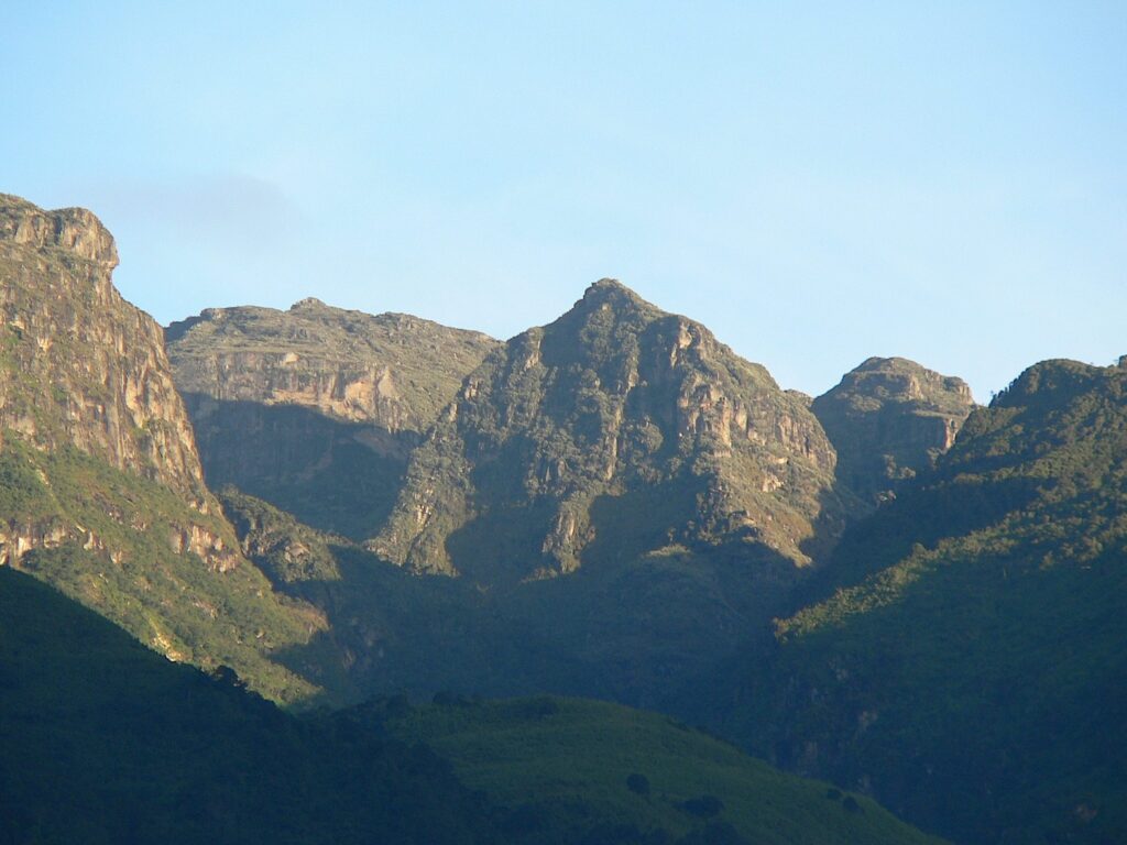
Few places on earth carry the weight of legend quite like the Rwenzori Mountains. Rising in utter defiance of equatorial logic, snowcapped, glaciered, and permanently shrouded in mist just thirty-three kilometers north of the Equator, these mountains have haunted the imagination of geographers, explorers, and adventurers for well over two thousand years. The ancient Greek scholar Ptolemy wrote of the “Mountains of the Moon” in the second century AD, a distant, mythical range whose melting snows he believed fed the Nile. For centuries, the world dismissed their existence as fantasy. Then, in 1889, the mountains materialized from the clouds for British explorer Henry Morton Stanley, revealing something far stranger and more spectacular than any myth had prepared him for.
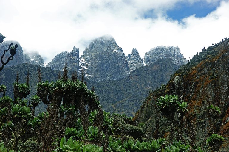
Standing before the Rwenzori for the first time as a guide, I am struck every single time by the same thing: this range does not look like Africa. The landscapes unfold as you climb through dripping montane forest, past alien giant lobelias standing three meters tall, across sphagnum bogs, and into a world of permanent cloud, rock, and ice belonging to no familiar category. The Rwenzori are neither a single volcanic cone nor a conventional massif. They are something altogether older, stranger, and more complex. They are a UNESCO World Heritage Site. They are Africa’s third-highest mountain range. They are, by any measure, the most botanically and geologically remarkable mountains on the continent.
This article is your definitive guide to the Rwenzori Mountains covering everything from geology and ecology to the six major peaks, the three trekking routes, wildlife, the best time to visit, how to prepare, what it costs, and precisely why these mountains deserve a permanent place at the top of every serious trekker’s list. This is the place to find everything you need, whether you’re researching the Rwenzori for the first time or planning an expedition.
The Rwenzori Mountains form a compact, north-south-trending range straddling the border between western Uganda and the eastern Democratic Republic of Congo. The range stretches approximately 120 kilometers in length and 50 kilometers wide, occupying a total area of around 1,000 square kilometers in Uganda alone. Its extent is protected within Rwenzori Mountains National Park, which was gazetted in 1991 and inscribed as a UNESCO World Heritage Site in 1994. In 2008, the range was additionally designated a Ramsar wetland of international importance, recognizing its irreplaceable hydrological role in eastern and central Africa.
Unlike the volcanic giants that dominate East Africa, Kilimanjaro, Mount Kenya, the Virungas, and the Rwenzori are a block mountain system, thrust upward by tectonic forces along the western rift valley over the last ten million years. The result is a collection of ancient rocks like gneiss, granite, and amphibolite that have been shaped over thousands of years by glaciers into a complicated landscape with deep valleys, cirques, ridges, and high lakes. The park’s elevations span an extraordinary range, from approximately 1,600 metres at its lowest point to 5,109 metres at the summit of Margherita Peak on Mount Stanley, the highest point in Uganda and the third-highest on the African continent.
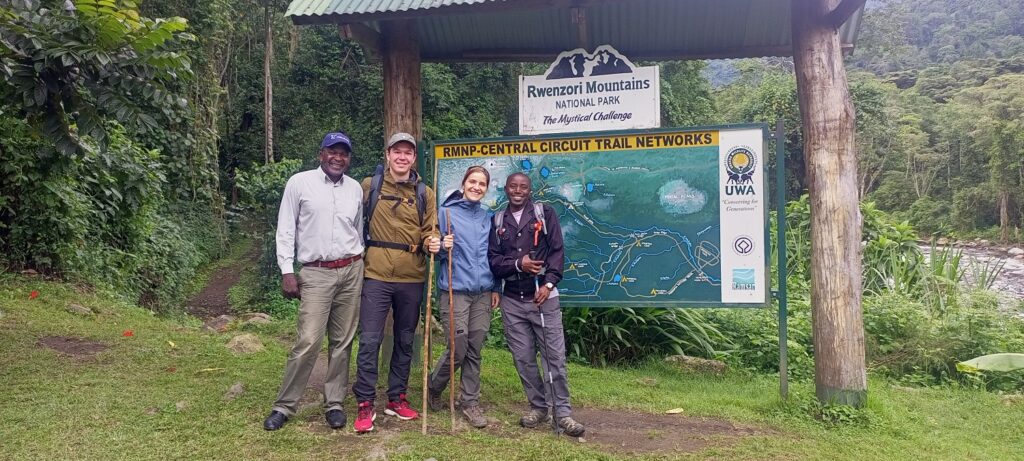
The range is administered by the Uganda Wildlife Authority (UWA), which oversees all trekking permits, guide certification, and conservation management across the Ugandan side. Crucially, the Rwenzori are one of the very few mountains in Africa where professional guides are mandatory by law, a requirement that reflects both the genuine technical difficulty of the terrain and the importance of supporting the mountain’s indigenous communities.
The Name “Mountains of the Moon”: History, Myth and Exploration
The name Mountains of the Moon did not originate with European explorers. Arab traders and geographers of the medieval period wrote of Jabal al-Qamar, literally the Mountains of the Moon, as a mystical source of Nile waters deep in the African interior. Ptolemy’s second-century description drew on these accounts, and the name became embedded in the Western imagination for nearly seventeen centuries before a European set eyes on the range. The full history of the Rwenzori Mountains’ name and discovery is one of the fascinating stories of geographic mystery and eventual revelation.
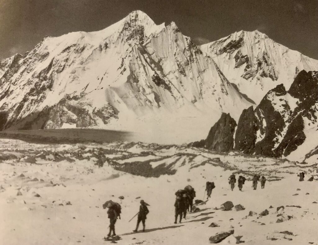
It was Henry Morton Stanley who, during his 1889 Emin Pasha Relief Expedition, finally glimpsed the snow-covered summit through the clouds and understood that here, straddling the equator, were the mountains that had populated cartographers’ imaginations for so long. Stanley named the highest peak, Mount Stanley, in his honor. But it fell to a supremely organized Italian expedition led by Luigi Amedeo, Duke of Abruzzi, to complete the first systematic scientific exploration and the first ascents of the major summits in 1906. The Duke’s team named peaks after the Italian royal family: Margherita, after Queen Margherita of Savoy; Vittorio Emanuele on Mount Speke; and Edward Peak on Mount Baker. Those names remain in use today.
The local name for the mountains Rwenzori derives from the Bakonzo language and means roughly “place of snow” or “rainmaker.” Both descriptions are apt. The mountains generate their own weather systems, capturing moisture from the Congo Basin and releasing it in the form of rain, cloud, and ice that feeds the Semliki River system and, ultimately, the White Nile. For the Bakonzo people who have lived on these slopes for centuries, the Rwenzori are not merely a landscape but a living entity, a spiritual presence that has shaped every aspect of their culture.
Geology: How the Rwenzori Were Made
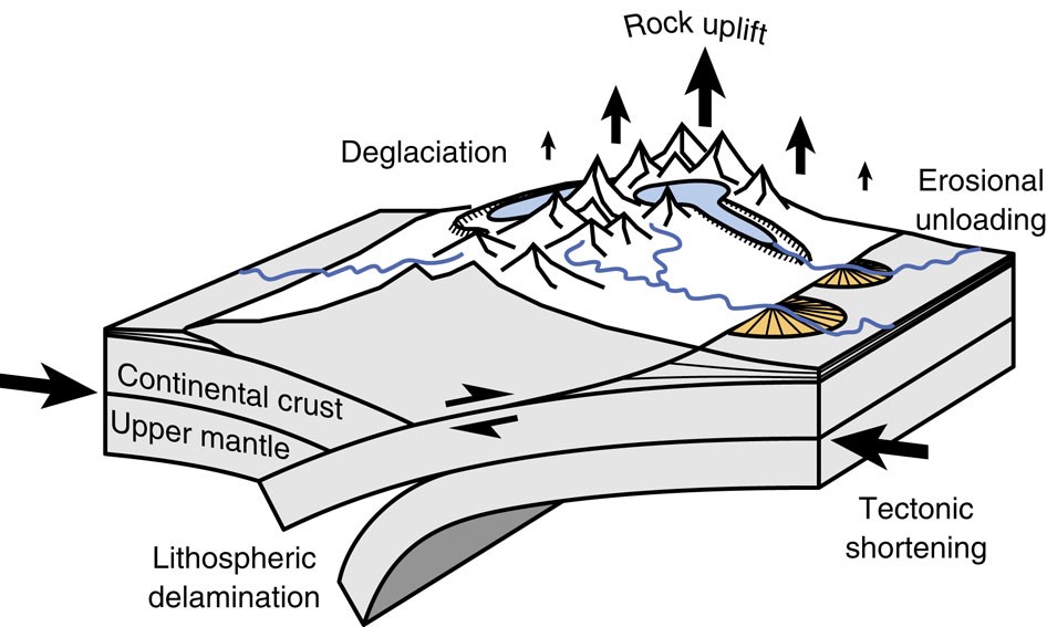
The geological story of the Rwenzori is as dramatic as their topography. Every major mountain in East Africa, except for these, is volcanic. They rose not from eruption but from the slow, irresistible force of crustal movement along the western branch of the East African Rift System. The detailed account of this block mountain formation explains how, over millions of years, a segment of Precambrian basement rock, among the oldest on earth, dating to perhaps 2.5 billion years ago, was displaced upward along steep fault scarps while the surrounding rift valleys subsided. The Rwenzori block moved up by roughly 3,000 meters relative to the valley floors flanking it.
What this process means in practice for the trekker standing on the Bujuku Valley floor and staring up at the Stanley Plateau is that you are looking at ancient rock that once lay kilometers beneath the surface of the earth. The crystalline faces, the sharp ridgelines, and the sheer cirque walls that back every high-altitude camp are all expressions of this ancient tectonic violence. The glaciers that once covered most of the upper range carved the topography further, creating the U-shaped valleys and the chain of high-altitude lakes that make the Rwenzori landscape so visually distinctive. Today those glaciers are in catastrophic retreat.
The Six Major Peaks of the Rwenzori Mountains
The Rwenzori are not one mountain but a family of six distinct massifs, each with multiple named peaks. Understanding their individual characters is essential both for planning an expedition and for appreciating the range’s remarkable complexity. All six peaks are trekked by expeditions operating from the Ugandan side, and collectively they form the objective of the magnificent 13-day, 6-peaks grand expedition, the most complete Rwenzori experience available.
Mount Stanley (5,109 m), the Roof of Uganda.
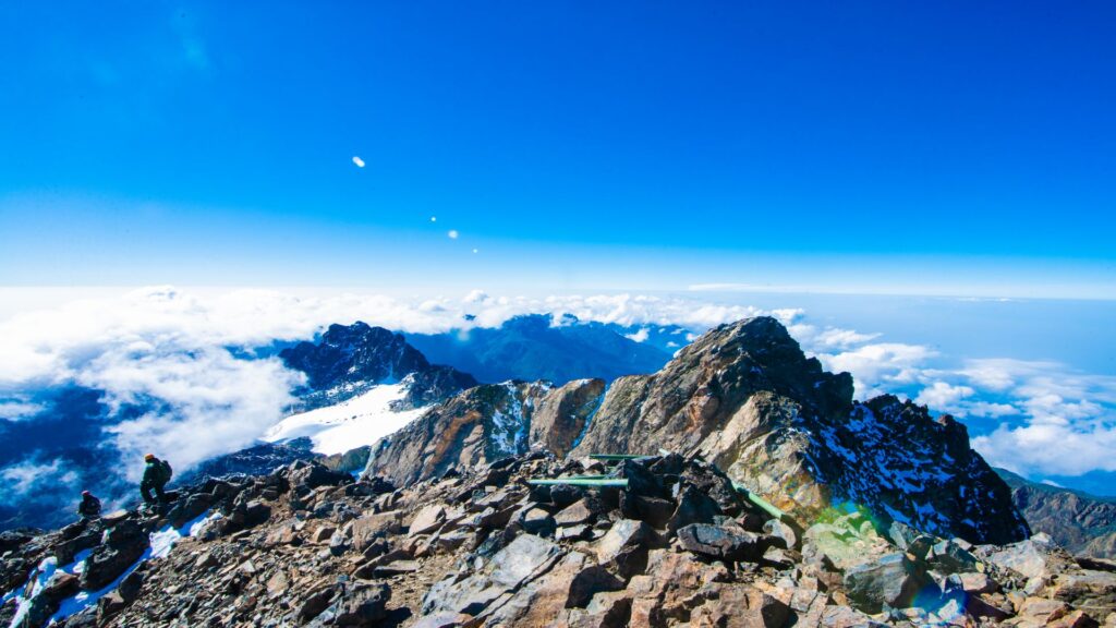
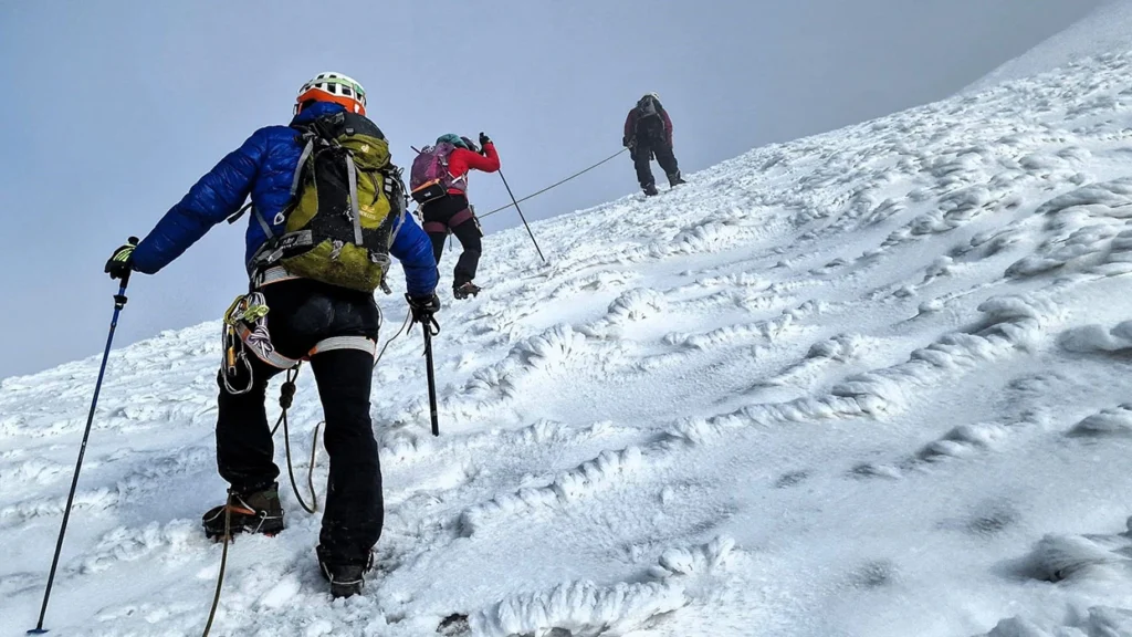
Mount Stanley is the undisputed centerpiece of the Rwenzori,, the highest point in Uganda, the highest in the Democratic Republic of Congo, and the third-highest summit in Africa after Kilimanjaro and Mount Kenya. The massif carries three major summits: Margherita Peak (5,109m), Alexandra Peak (5,091m), and Albert Peak (5,087m). The wide, heavily glaciated Stanley Plateau that connects these summits is one of the most extraordinary landscapes on the continent, a frozen high-altitude plain sitting on the equator, ringed by ice and cloud.
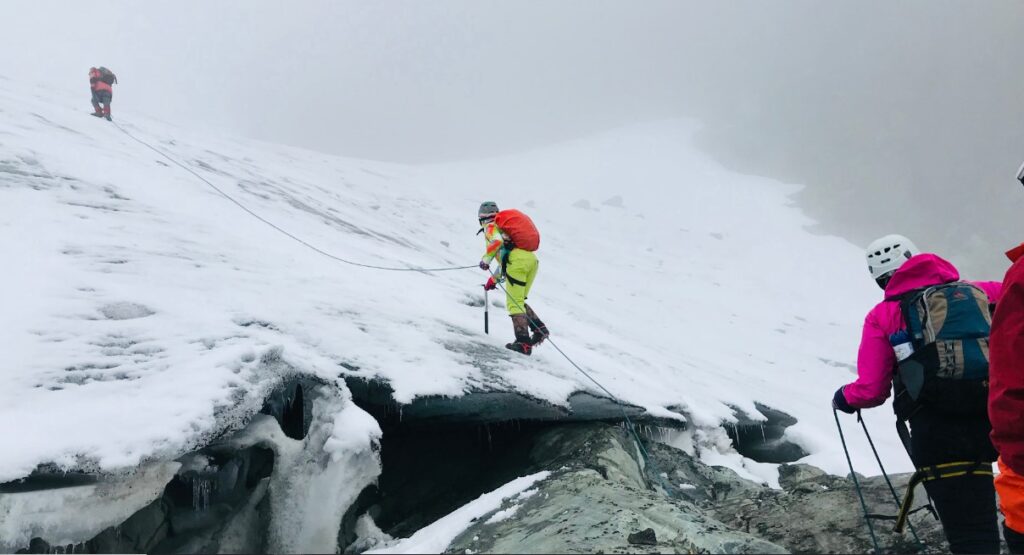
Reaching Margherita from the Ugandan side requires crossing the Stanley Glacier, navigating fixed ropes on steep rock sections above Elena Hut, and moving confidently on mixed terrain. It is not a technical mountaineering objective in the alpine sense, but it demands fitness, sound acclimatization, and respect for rapidly changing conditions. The standard approach takes a minimum of seven days, with most experienced operators recommending eight or more to allow proper acclimatization.
Mount Speke (4,890m): The Second Summit.
Rising to 4,890 meters at its highest point, Vittorio Emanuele Peak, Mount Speke, is the second-highest massif in the Rwenzori and one of the most visually striking. From the Bujuku Valley, Speke presents an imposing wall of rock and ice on its eastern face, while its western flanks drop into the Congo. The peak offers a technically demanding but deeply rewarding climb, typically accessed via the Stuhlmann Pass route as part of multi-peak itineraries. Speke is an exceptional objective for climbers seeking a slightly less crowded summit experience than Margherita while still reaching genuine high altitude.
Mount Baker (4,843m): The Freshfield Pass Giant.
Named after the English geographer Samuel White Baker, Mount Baker reaches 4,843 meters at Edward Peak. It sits at the southern end of the main massif cluster and is most commonly accessed via the Scott Elliot Pass or Freshfield Pass, the latter connecting the Bujuku and Kitandara valleys in one of the most scenically dramatic traverses in the entire range. The 5-day trek to Edward Peak is a legitimate summit itinerary that suits trekkers who want high-altitude achievement without the full technical demands of Margherita.
Mount Emin (4,798m): The Remote Giant.
At 4,798 metres, Mount Emin is the fourth-highest massif and perhaps the most remote in the range. Named for Emin Pasha, the governor of Equatoria, whose relief the Stanley expedition had set out to achieve, Emin sits at the northern end of the range and requires a dedicated multi-day approach. Because few climbers attempt the twin summits, Umberto and Kraepelin, a successful ascent is a genuinely exclusive achievement.
Mount Gessi (4,715m): The Hidden Peak.
Rising to 4,715 metres at Bottego Peak, Mount Gessi occupies the far northern portion of the range and shares with Emin the character of a mountain seldom visited. The Duke of Abruzzi’s expedition named its twin summits, Bottego and Iolanda, after Italian explorers of Africa. The dedicated 7-day Mount Gessi trek is one of the most adventurous options in the entire Rwenzori portfolio, taking trekkers deep into a part of the range that sees perhaps a few dozen visitors per year.
Mount Luigi di Savoia (4,627m): The Southern Sentinel.
The southernmost and lowest of the six major massifs, Mount Luigi di Savoia peaks at 4,627 metres at Sella Summit, with Weismann Peak at 4,620 metres offering a slightly more accessible alternative objective. The mountain is named after the Duke of Abruzzi himself, Luigi Amedeo di Savoia, in recognition of his foundational role in the Rwenzori exploration. The 6-day expedition to Weismann Peak via the Kilembe Trail remains one of the most popular intermediate-level objectives in the range.
Rwenzori Major Peaks, Quick Reference.
Mountain
Highest Peak
Elevation
Character
Mount Stanley
Margherita Peak
5,109m
Glaciated; highest in Uganda & DRC
Mount Speke
Vittorio Emanuele
4,890m
Imposing east face; technical approach
Mount Baker
Edward Peak
4,843m
Freshfield Pass; scenic traverses
Mount Emin
Umberto & Kraepelin
4,798m
Remote northern; rarely climbed
Mount Gessi
Bottego & Iolanda
4,715m
Far north; seldom visited
Mount Luigi di Savoia
Sella & Weismann
4,627m
Southernmost; accessible objective
Vegetation Zones and the Ecology of the Rwenzori
The Rwenzori mountain range is unmatched in the world for its biological strangeness and diversity. The range passes through five distinct vegetation zones, each more extraordinary than the last, stacked vertically from the cultivated foothills to the permanent ice. Ascending the Rwenzori is not merely a physical challenge; it is a journey through five entirely different worlds, each with its climate, soils, plants, and atmosphere.
The lowest zone, the montane forest, begins at around 1,600 metres and rises to approximately 2,500 metres. This is the world of dripping canopies, strangler figs, olive trees, and the extraordinary sound of the Rwenzori turaco, an endemic bird with crimson wing-flashes that cuts through the greenery like a bolt of stained glass. This zone is inhabited by chimpanzees and colobus monkeys, while three-horned Jackson’s chameleons creep along moss-covered branches, and the forest floor remains soft from centuries of decomposing vegetation.
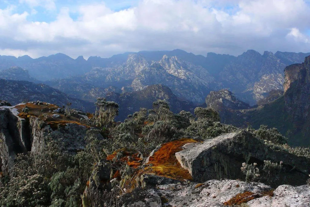
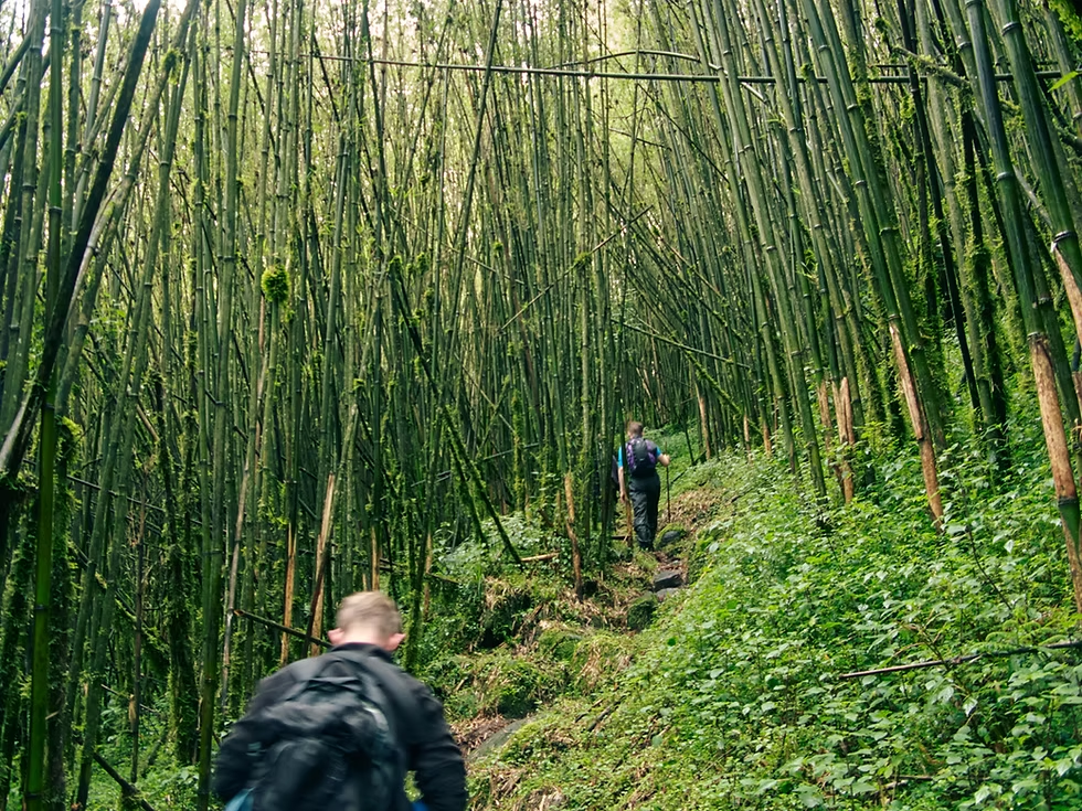
Above the forest lies the bamboo zone, a relatively narrow band at 2,500–3,000 metres where dense groves of highland bamboo create an enclosed, cathedral-like atmosphere. This transitions quickly into the heathland zone, open moorland dominated by tree heathers growing to extraordinary heights, their trunks thick with ancient moss. Here the weather begins to shift: clouds build with terrifying speed, temperatures drop sharply at night, and the first hints of the otherworldly Afro-alpine vegetation begin to appear.
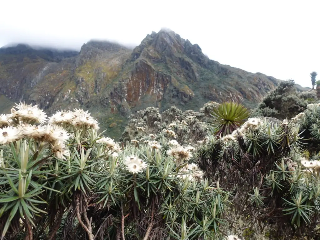
The afro-alpine zone is what makes the Rwenzori visually unlike anywhere else on earth. Between roughly 3,500 and 4,500 metres, you enter a landscape of giant groundsels (Senecio adnivalis) and giant lobelias (Lobelia wollastonii), species that grow nowhere else in quite the same form. The giant groundsels reach five meters in height; their rosettes are the size of parasols. The lobelias stand as sentinel columns, their flower spikes blue and silver in the mist. Underfoot, sphagnum moss creates a saturated, bouncing surface that consumes boots and gaiters and tests even the most waterproof of footwear, which is why choosing the right boots is such a critical decision for Rwenzori trekkers.
Finally, above 4,500 metres, the vegetation gives way to the nival zone, a world of bare rock, ice, and permanent snow where almost nothing grows. This area is where the Rwenzori glaciers live and where the atmosphere, the silence, and the cold combine to produce an experience utterly removed from the tropical Africa below.
Wildlife of the Rwenzori Mountains
The Rwenzori Mountains National Park harbors a remarkable concentration of endemic and rare species. The wildlife guide to the Rwenzori documents over 70 species of mammal, more than 200 bird species, and extraordinary concentrations of endemic amphibians and reptiles. Perhaps this mountain range is unique in its area for containing so many species found nowhere else on earth.
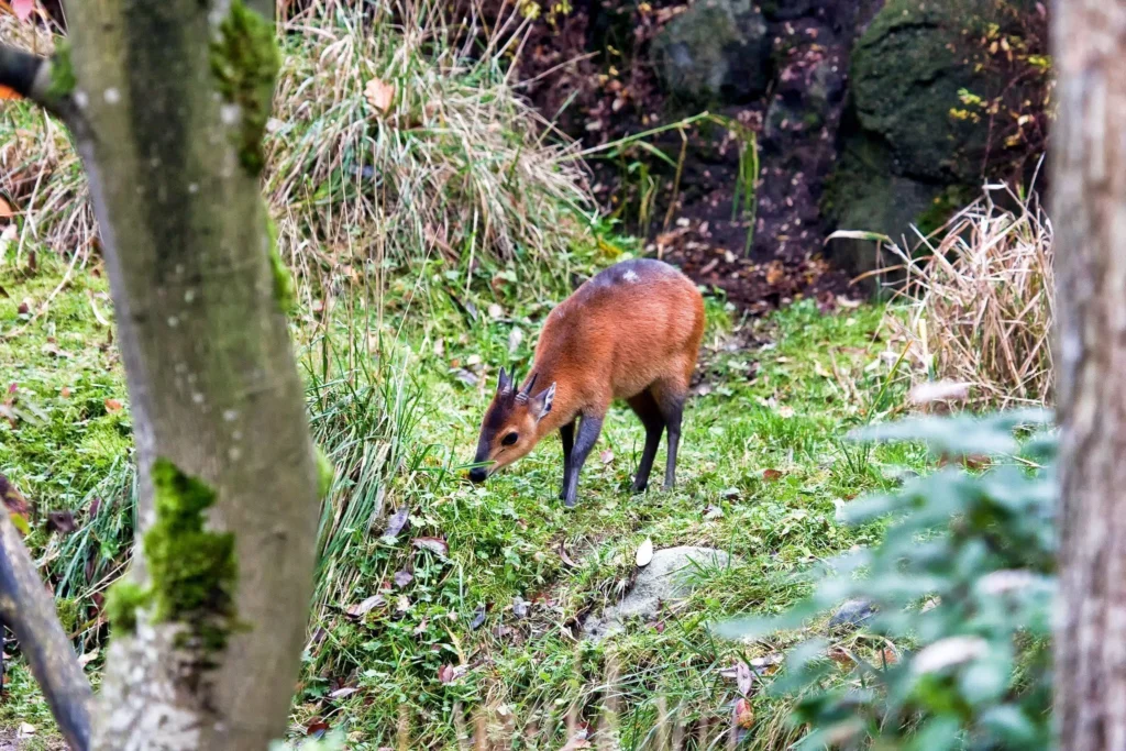
Rwenzori Duiker
Among mammals, chimpanzees are the headline species in the montane forest zone, along with L’Hoest’s monkeys, colobus monkeys, giant forest hogs, duikers, and forest elephants. The elusive Rwenzori leopard, a melanistic variant of the African leopard, inhabits the forest and heathland zones, rarely seen but regularly encountered through tracks and vocalizations at night. Higher up, the rock hyrax emerges from boulder fields at dawn, issuing its extraordinary wailing alarm call that carries extraordinary distances in the thin, still air of the Afro-alpine zone.
For birders, the Rwenzori offer some of the most exciting endemic species in Africa: the Rwenzori turaco, the handsome francolin, the strange-weaver, the Rwenzori nightjar, and the Dwarf honey-guide, among many others. The park sits within one of Africa’s most important bird areas, and serious birders often extend their time in the lower forest zones specifically to maximize species counts.
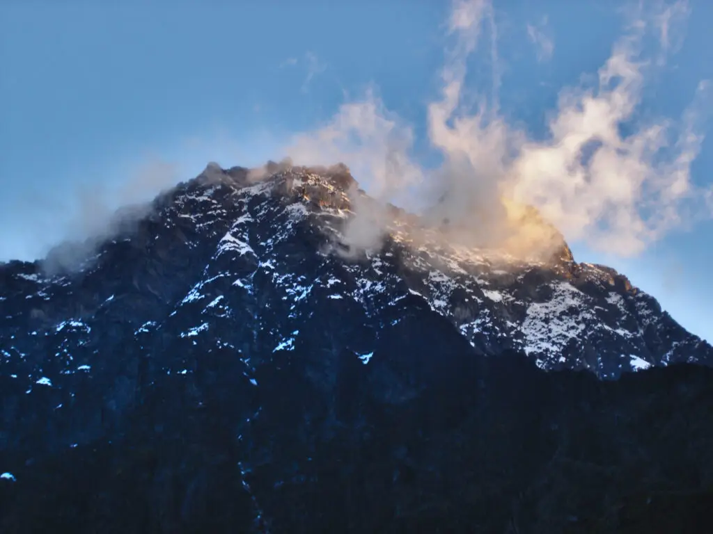
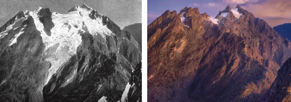
One of the most urgent stories in Rwenzori is about loss. The glaciers that once covered approximately 6.5 square kilometers of the upper mountain at the beginning of the twentieth century have retreated dramatically. By the most recent measurements, the Rwenzori glaciers have contracted by over 80% since 1906, and scientific modeling suggests that total glacial loss is likely within the next few decades unless global warming trends are reversed. The full picture of this glacier retreat and its causes is among the most compelling and sobering stories in contemporary African conservation.
What this phenomenon means for trekkers, in practical terms, is that the Rwenzori glaciers are not just a spectacle; they are a ticking clock. The Elena Glacier, visible from Elena Hut at 4,541 metres, is still strikingly beautiful, but it is measurably smaller than it was a decade ago. The Stanley Plateau still carries significant ice cover, but the margins retreat year by year. Crossing glacial ice on the summit approach to Margherita Peak is still a standard experience on well-guided expeditions today, but it may not be available to the next generation of trekkers. This assertion is not hyperbole. This is the scientific consensus.
Guide Insight
Every time I summit Margherita Peak, I make a point of looking at the Elena Glacier from the hut below and comparing it to photographs I took on my first ascent twelve years ago. The retreat is visible. If seeing the equatorial glaciers of the Rwenzori is on your list, do not wait.
The Three Trekking Routes into the Rwenzori
The Rwenzori Mountains offer three distinct ascent routes from the Ugandan side, each with its own character, infrastructure, and summit access. Choosing the right route for your goals and experience is one of the most important decisions in Rwenzori planning. A thorough comparison of all three routes provides the full picture.
The Central Circuit Trail
The Central Circuit Trail is the classic Rwenzori route and the one that most international trekkers choose for their first expedition. Beginning from the Nyakalengeji trailhead in Ibanda, Kasese District, the trail loops through the heart of the range, traversing the Bujuku Valley, crossing the Scott Elliot Pass and the Freshfield Pass, and approaching Margherita Peak via Elena Hut. The huts along this route, Nyabitaba, John Matte, Bujuku, Elena, and Kitandara, are well-established metal refuges with cooking facilities, and their spacing creates a natural acclimatization rhythm for trekkers.
The Central Circuit is the preferred route for 7-day Margherita Peak expeditions and longer multi-peak itineraries. It is also the route that provides access to the widest range of the Rwenzori’s vegetation zones and the one most likely to produce sightings of chimpanzees and L’Hoest’s monkeys in the lower forest sections. The trail itself is physically demanding, steep, often waterlogged, and requires careful footwork, but it is navigable for fit, well-prepared trekkers without technical climbing experience up to the Elena Glacier crossing.
The Kilembe Trail
The Kilembe Trail is the alternative major route and, in the opinion of many guides, the more dramatically scenic of the two. Beginning from the Kilembe copper-mining village near Kasese, the trail ascends through a different set of valleys and vegetation zones before converging on the upper mountain. The 8-day Kilembe Trail expedition to Margherita Peak is managed in partnership with Rwenzori Trekking Services (RTS) and offers a superb combination of lowland scenery and high-altitude achievement.
The Kilembe Trail is particularly well-suited to trekkers who want to avoid the Central Circuit’s sometimes narrow and crowded hut system, and it is the natural choice for those approaching from the southern end of the range. Kilembe is outstanding for trekkers who want to see Weismann Peak on Luigi di Savoia instead of Margherita or who wish to approach the upper mountain from a different angle. A detailed comparison of the Central Circuit and Kilembe Trail helps clarify which route is better suited to individual goals.
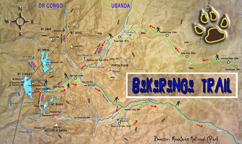
The Bukurungu Wilderness Camping Trail
The Bukurungu Trail is the newest and most remote of the three routes, developed through a partnership between the Uganda Wildlife Authority and WWF in 2018. It is a wilderness camping experience in the truest sense: no huts, no permanent infrastructure, no other trekkers. The trail passes through four high-altitude alpine lakes, Irene, Mughuli, Bukurungu, and Bujuku, in a sequence of landscapes that feels genuinely unexplored. Bukurungu stands out as a unique option for trekkers who have already completed the Central Circuit or Kilembe and wish to explore the wild interior of the Rwenzori further.
Trekking and Climbing Options: From Day Hikes to Grand Expeditions
One of the outstanding strengths of the Rwenzori as a destination is the range of experiences on offer. The full portfolio of Rwenzori treks spans everything from a gentle forest walk that can be completed in a day to a comprehensive 18-day expedition summiting all eight major Rwenzori peaks. Whatever your available time, fitness level, or ambition, there is a Rwenzori itinerary calibrated to your objectives.
At the shorter end of the spectrum, the 2-day trek to Sine Camp and the 2-day Lake Mahoma hike both offer genuine mountain forest immersion without the commitment of a full summit push. These shorter options are ideal for travelers combining the Rwenzori with a broader Uganda itinerary, for those who want to gauge their fitness before committing to a longer expedition, or for families and less experienced hikers. The 4-day Mutinda Lookout trek takes this a step further, reaching 4,000 meters for genuinely panoramic views before descending for a superb acclimatization-style experience that creates a lasting impression.
For those committed to reaching Margherita Peak, the 7-day Central Circuit climb remains the benchmark itinerary long enough to acclimatize properly and short enough to be achievable within a typical travel schedule. The 8-day Kilembe Trail offers an extra day on the mountain, which translates to meaningfully better acclimatization and, in most guides’ experience, a significantly higher success rate. For those with ambitions beyond Margherita, the 8-day 3-peaks trek combining Stanley, Speke, and Baker is a serious undertaking that demands excellent fitness and previous high-altitude experience.
At the pinnacle of Rwenzori ambition sits the 18-day all-peaks expedition, an undertaking that covers all eight named summits across the range and is, in every meaningful sense, the completion of the Rwenzori. Fewer than a handful of teams per year attempt this itinerary. For those without quite that much time, the 13-day 6-peaks grand expedition covering all six major massifs is the most comprehensive experience available within a conventional expedition timeframe.
How Hard Is the Rwenzori Trek?
This inquiry is one of the most commonly asked questions in Rwenzori planning, and it deserves a genuinely honest answer. The detailed assessment of how hard the Rwenzori trek actually is covers terrain, altitude, weather, and physical demands comprehensively, but the summary version is as follows: the Rwenzori is harder than Kilimanjaro and easier than technical alpine routes. It is harder than Kilimanjaro primarily because of the terrain rather than the altitude. The Rwenzori are wetter, muddier, technically more demanding underfoot, and far more navigationally complex. The altitude at Margherita Peak, 5,109 metres, is lower than Kilimanjaro’s summit of 5,895 metres, but the approach routes pass through more sustained difficult terrain over more days.
The key difficulty factors for Rwenzori are threefold. First, the mud and waterlogging of the lower trails require excellent waterproof footwear, strong ankles, and a certain philosophical acceptance of being permanently wet. Second, the technical mixed terrain on summit day, the Elena Glacier, and the rock sections above it require crampons, ice axes, and the confidence to move on steep ground. Third, altitude and the associated risks of acute mountain sickness require respect for a sound acclimatization strategy. The beneficial news is that every one of these challenges is manageable with proper preparation and professional guiding.
The 16-week training plan developed for Rwenzori trekkers addresses the specific physical demands of walking with a loaded pack, cardiovascular endurance, core stability, and lower-body strength for steep, uneven ground. Trekkers who follow a structured preparation program and arrive physically prepared consistently report a more enjoyable and more successful experience than those who rely on general fitness alone. The guide for beginners addresses specifically whether the Rwenzori is appropriate for first-time mountain trekkers, and the guide for older trekkers provides honest advice for those over 50 or 60.
The Bakonzo People: Guardians of the Mountains.
No account of the Rwenzori Mountains is complete without acknowledging the Bakonzo people, the indigenous community who have lived on and around these mountains for centuries. The Bakonzo, known also as the Baamba or Bamba in some areas, are the original Rwenzori guides, porters, and mountain stewards. Their intimate knowledge of the terrain, the weather patterns, and the mountain’s moods is the single most important safety asset available to any trekking team. Our professional mountain guides and porter teams are drawn entirely from Bakonzo communities, ensuring that the economic benefits of mountaineering tourism flow directly to the people who have the deepest stake in the mountain’s health.
Tipping your guide and porter team is not an optional courtesy; it is an economic imperative. The porter and guide tipping guide sets out the accepted norms in detail, but the principle is simple: your guides and porters work extraordinarily hard in difficult conditions, they carry loads that would defeat most trekkers, and the income they earn directly supports families and communities in one of Uganda’s more remote and economically marginalized regions. Tipping appropriately is one of the most tangible ways a trekker can practice responsible mountain tourism.
Best Time to Visit the Rwenzori Mountains
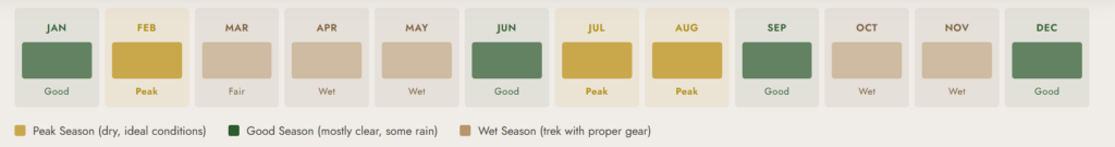
The best time to visit the Rwenzori is a question that requires more nuance than a simple two-month recommendation. Unlike drier East African mountains, the Rwenzori receives precipitation year-round as a function of its unique position in the convergence zone between the Congo Basin moisture and the East African anticyclone. No month is entirely dry.
That said, two periods are notably drier and therefore preferable for most trekkers: December to February (the short dry season) and June to August (the long dry season). During these windows, trails are firmer underfoot, summit day weather is more frequent, and visibility at altitude is more reliably excellent. Peak season, particularly July, sees the highest volume of visitors, though even then, with a total of roughly 1,000 trekkers per year visiting the Rwenzori compared to over 50,000 on Kilimanjaro, the mountain never feels crowded.
The wet seasons of March to May and October to November bring heavier rain, muddier trails, and lower summit visibility. They also bring dramatically lower prices, quieter conditions, and an atmosphere of particular wildness and mystique that many experienced mountain travelers actually prefer. The Rwenzori in mist and rain is a different beast from the Rwenzori in clear weather, but it is no less compelling. With the right waterproof gear, a sound guide, and appropriate expectations, the wet season offers a legitimate and rewarding Rwenzori experience.
Getting to the Rwenzori Mountains
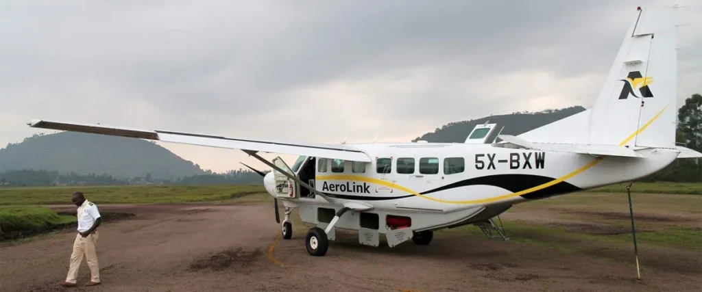
Access the Rwenzori Mountains through Kasese town, a mid-sized service town in western Uganda approximately 420 kilometers southwest of Kampala. The detailed travel guide to getting to the Rwenzori covers all options, but the standard approaches are as follows. Most international trekkers fly into Entebbe International Airport, Uganda’s main gateway, and either connect on a scheduled domestic flight to Kasese Airport or make the 5–6-hour overland journey by private transfer via the Fort Portal road. The drive through the Ugandan countryside offers a memorable experience, especially as you approach Kasese and see the first distant views of the Rwenzori on the western horizon.
Kasese is the trailhead town for both the Central Circuit (via Ibanda, 22 kilometers north of Kasese) and the Kilembe Trail (via Kilembe village, 13 kilometers from Kasese). The town offers a range of accommodation options, and pre- and post-trek accommodation near both the mountain and in Fort Portal is readily available at various price points. We strongly recommend arriving a day before your trek begins to rest, sort gear, and meet your guide team.
The Cost of Climbing the Rwenzori Mountains
The full cost breakdown for a Rwenzori trek is a longer discussion than can be fully addressed here, but the essential structure of costs involves park entry fees from the Uganda Wildlife Authority and daily concession fees, guide and porter wages (mandatory for all trekkers), accommodation in mountain huts or camps, and the agency’s organizational and logistics fee. For a standard 7–8-day guided expedition to Margherita Peak, trekkers should budget in the range of USD 1,800–2,500 per person depending on group size and the specific itinerary.
It is worth noting that the Rwenzori’s cost compares very favorably with Kilimanjaro, where the combination of park fees, guide fees, and competitive agency pricing typically produces a total cost of USD 2,500–4,000 or more for a similar 7–8-day summit itinerary. The Rwenzori offers arguably a more challenging, more exclusive, and more biodiverse mountain experience at a lower overall cost, which contributes to the case that it is, in many ways, Africa’s best mountain trek. For those looking to reduce expenditure further, the budget trekking guide identifies legitimate cost savings without compromising safety.
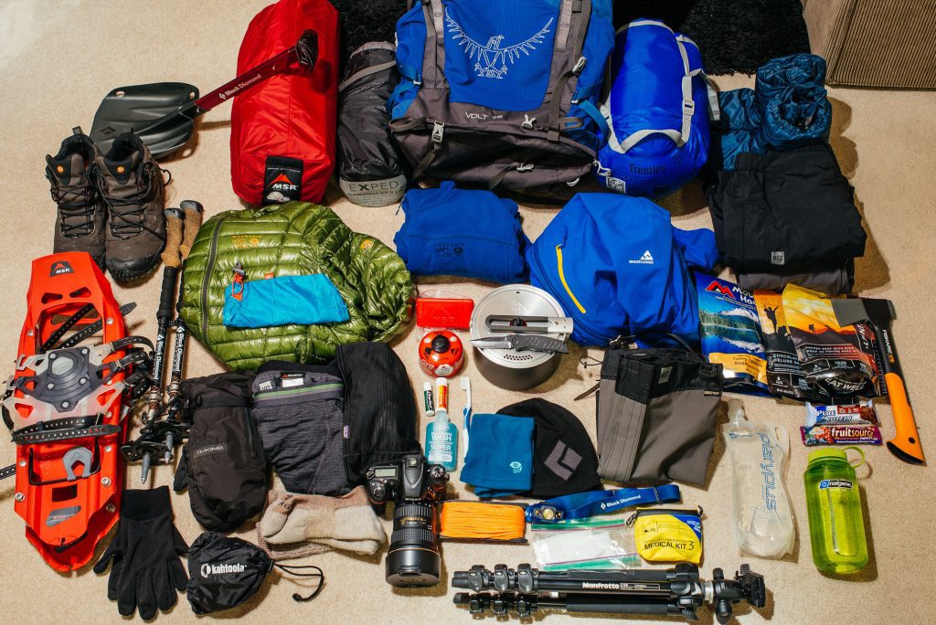
Essential Gear and Preparation
The Rwenzori demands specific gear choices that differ meaningfully from those appropriate for drier mountains. The complete packing list for a Rwenzori trek covers everything in detail, but the single most important decision is footwear. The saturated, boggy terrain of the Rwenzori’s lower and middle zones where sphagnum moss and waterlogged peat can absorb a knee without warning makes the standard advice of “sturdy hiking boots” completely inadequate. What the Rwenzori actually requires is rubber.Wellington-style boots over waterproof gaiters, a combination that will keep feet drier, warmer, and more secure on the boggy terrain than any conventional hiking boot, however expensive and waterproof.
Beyond footwear, key gear priorities include a high-quality sleeping bag rated for sub-zero temperatures. Elena Hut, at 4,541 meters, regularly falls below freezing overnight. You need multiple waterproof layers, trekking poles (essential for bog navigation and steep descents), and a headtorch with spare batteries for the pre-dawn summit start. Staying warm at the summit requires a specific layering strategy in conditions that combine cold, wind, and high humidity in ways that drain body heat faster than dry-cold environments. Our guides will brief you fully on layering and safety protocols at the pre-trek meeting.
Travel insurance for a Rwenzori trek is not optional. The Rwenzori travel insurance guide outlines precisely what cover is required: helicopter evacuation, high-altitude rescue, emergency medical treatment, and trip cancellation. Standard travel insurance policies rarely cover these elements without specific adventure sports riders.
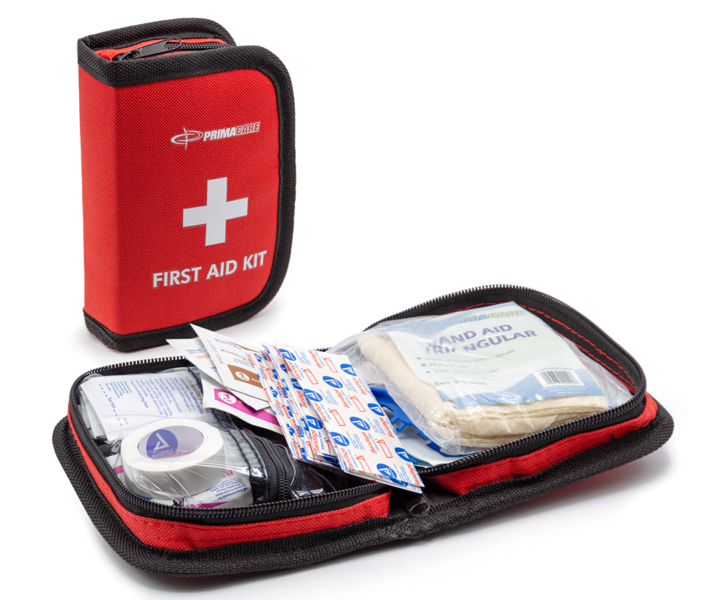
Health and Safety on the Rwenzori
The complete medical guide to trekking the Rwenzori covers altitude sickness, hypothermia, trench foot, and the range of other health challenges that Rwenzori trekkers may encounter. The most important points to understand upfront are these: altitude sickness is real at Rwenzori elevations, even though the mountain’s peak altitude is lower than Kilimanjaro or many Himalayan treks. Sustained effort, wet cold, and relatively fast ascent profiles on shorter itineraries require serious attention to acclimatization. Any guide worth their certification will monitor trekkers daily for AMS symptoms and will enforce descent if those symptoms progress.
Itinerary length, physical preparation, and the quality of guiding significantly impact the summit success rate for Margherita Peak. Well-prepared trekkers on appropriately long itineraries with experienced guides achieve very high success rates. The most common cause of failure is not inadequate fitness but inadequate acclimatization, a problem that eight-day and longer itineraries specifically address.
Safety Notice
All trekkers must be accompanied by a UWA-certified guide. Solo trekking is not permitted within the national park under any circumstances. All guides operating with Rwenzori Trekking Safaris carry emergency communication devices and are trained in first aid, altitude management, and mountain rescue protocols.
Combining the Rwenzori with Uganda Safaris
Uganda’s extraordinary concentration of wildlife, primates, and national parks makes the Rwenzori an ideal centerpiece for a broader East African adventure. The mountains sit in the heart of western Uganda’s wildlife corridor. Queen Elizabeth National Park lies immediately to the south, offering world-famous tree-climbing lions, an extraordinary Kazinga Channel boat safari, and some of the most diverse large mammal concentrations in East Africa. To the southwest, Bwindi Impenetrable Forest, another UNESCO World Heritage Site, is the home of roughly half the world’s remaining mountain gorillas.
The combination of Rwenzori mountaineering and gorilla trekking is, in my experience, the most rewarding single itinerary available in Africa. No other trip combines the physical achievement of a high-altitude mountain expedition with the deeply moving experience of sitting in the presence of mountain gorillas in their forest habitat. Our 12-day Rwenzori and gorilla trekking package is designed specifically to deliver both experiences within a two-week itinerary, and it has become one of our most popular combined offerings. For those with more time, the 19-day Uganda grand adventure adds chimpanzee trekking in Kibale Forest, big-five wildlife at Queen Elizabeth, and white-water rafting on the Nile at Jinja for the most comprehensive Uganda experience possible.
The Rwenzori vs Kilimanjaro: Africa’s Great Mountains Compared
The inevitable comparison between the Rwenzori and Kilimanjaro is one that every serious African mountaineer will weigh. The detailed Rwenzori vs Kilimanjaro analysis examines the two mountains across difficulty, scenery, biodiversity, cost, crowd levels, and overall experience. The headline conclusion: they are complementary experiences that reward different qualities in a trekker.
Kilimanjaro is higher (5,895 m vs. 5,109 m), more straightforward in terms of terrain, more heavily commercialized, and, with 50,000+ annual trekkers, enormously more visited than the Rwenzori’s approximately 1,000 annual visitors. The Rwenzori is technically harder, vastly more biodiverse, far more exclusive, cheaper, and, for those who value wilderness over high-altitude walking, significantly more rewarding. Many experienced mountain travelers who have climbed both describe the Rwenzori as the more profound and indelible experience. The question of whether the Rwenzori is worth climbing has, in our view, a clear answer: absolutely, emphatically yes.
Frequently Asked Questions About the Rwenzori Mountains
Where are the Rwenzori Mountains?
The Rwenzori Mountains are located in western Uganda, straddling the border with the Democratic Republic of Congo. The range lies approximately 33 kilometers north of the equator, near the town of Kasese, in what is designated Rwenzori Mountains National Park, a UNESCO World Heritage Site covering around 1,000 square kilometers. The mountains rise from approximately 1,600 metres at the park boundary to 5,109 metres at the summit of Margherita Peak on Mount Stanley.
Why are the Rwenzori called the Mountains of the Moon?
The name “Mountains of the Moon” is one of the oldest geographic names in the world, traced to the ancient Greek scholar Ptolemy, who, in the second century AD, described a distant equatorial mountain range whose melting snows fed the Nile. Arab geographers and traders referred to the range as Jabal al-Qamar, literally “Mountains of the Moon,” for centuries before Europeans reached Africa’s interior. The local Bakonzo name “Rwenzori” means roughly “place of snow” or “rainmaker.” The European name “Mountains of the Moon” was confirmed when Henry Morton Stanley sighted the range in 1889. The full history is documented in the history of the Rwenzori Mountains.
How high is the highest peak of the Rwenzori Mountains?
The highest peak is Margherita Peak on Mount Stanley, at 5,109 metres (16,762 feet) above sea level. Margherita Peak is the highest point in both Uganda and the Democratic Republic of Congo and the third-highest summit in Africa after Mount Kilimanjaro (5,895 m) and Mount Kenya (5,199 m). It stands on the Stanley Plateau alongside Alexandra Peak (5,091m) and Albert Peak (5,087m).
How many days does it take to climb the Rwenzori Mountains?
The minimum recommended duration for a summit attempt on Margherita Peak is 7 days, though 8 days is strongly preferred for better acclimatization and a higher success rate. Shorter 4–5-day summit itineraries exist but carry meaningfully higher risk of altitude sickness. For multi-peak expeditions, itineraries range from 9 to 18 days depending on the number of summits targeted. Shorter 2–4-day treks that do not attempt the summit are also available and offer excellent forest and lower-mountain experiences. The complete guide to how long a Rwenzori trek takes covers every option.
Is the Rwenzori trek suitable for beginners?
The Rwenzori is not recommended for absolute beginners with no prior mountain trekking experience, but it is achievable for well-prepared intermediates who have done significant multi-day walking and have some experience with elevation. The key requirements are cardiovascular fitness, strong legs for steep and uneven terrain, and the right gear, particularly boots. The beginners’ guide to climbing the Rwenzori addresses the topic honestly and in detail, including the specific preparation recommendations for first-time mountain trekkers.
What is the best time of year to trek the Rwenzori?
The two best periods are December to February and June to August, when rainfall is at its lowest and trail conditions are most manageable. June, July, and August are the peak season months and offer the best combination of trail conditions, visibility, and summit weather windows. The Rwenzori receives rain year-round and can be trekked in any month with the right preparation. The best time to visit the Rwenzori provides a month-by-month breakdown with rainfall data.
Do the Rwenzori Mountains still have glaciers?
Yes, though significantly reduced. The Rwenzori still carries active glaciers on the upper sections of Mount Stanley, most visibly the Elena Glacier above Elena Hut at 4,541 metres and the ice on the Stanley Plateau itself. However, these glaciers have retreated by more than 80% since 1906 and are expected to disappear entirely within the coming decades if current climate trends continue. Crossing glacial ice on the summit approach to Margherita Peak is still a standard part of guided expeditions today. Read the full story of the Rwenzori glacier retreat and climate change covered in detail on the site.
How much does it cost to trek the Rwenzori Mountains?
A fully guided 7–8-day expedition to Margherita Peak on the Rwenzori typically costs between USD 1,800 and USD 2,500 per person, covering park fees, guide and porter wages, mountain hut accommodation, and agency logistics. Shorter lower-mountain treks start from approximately USD 300–500. Multi-peak expeditions of 10–18 days are priced higher. For a comprehensive breakdown of all fees and costs, the full cost guide provides exact figures for 2025/26.
Is it safe to trek the Rwenzori Mountains?
Certified professional guides ensure an excellent safety record when trekking the Rwenzori Mountains. The most significant risks are altitude sickness, hypothermia, and injury from falls on technical terrain all of which are managed effectively through proper preparation, experienced guiding, and appropriate gear. The national park’s requirement for mandatory certified guides on all trekking routes is itself a major safety factor. The safety guide to trekking the Rwenzori covers hazards, safety protocols, and emergency procedures comprehensively.
What wildlife can I see in the Rwenzori Mountains?
The Rwenzori are home to over 70 mammal species and more than 200 bird species, with exceptionally high rates of endemism. Notable wildlife includes chimpanzees, L’Hoest’s monkeys, colobus monkeys, forest elephants, giant forest hogs, the Rwenzori leopard, Jackson’s three-horned chameleons, and over a dozen endemic bird species, including the Rwenzori turaco. The afro-alpine zone harbors unique botanical species, including giant lobelias and giant groundsels found nowhere else on earth. The Rwenzori wildlife guide provides a comprehensive species list and viewing tips.
Can I combine a Rwenzori trek with gorilla trekking?
Absolutely, and this is one of the most popular combined itineraries in Uganda. Bwindi Impenetrable Forest, home to roughly half the world’s remaining mountain gorillas, is approximately four hours from Kasese by road. The combination makes geographical and experiential sense, and our 12-day Rwenzori and gorilla trekking package is specifically designed to deliver both within a two-week itinerary. Gorilla permits should be booked well in advance, ideally three to six months ahead, as availability is strictly limited.
ANY QUESTIONS?
If you need any clarification about a Rwenzori trek, contact one of our trekking experts to start planning your journey today.
A 10% percentage of your safari proceeds goes to supporting the local Bakonjo Communities (orphans, schools & homes)
Hi there, welcome. Need help planning a trek, safari, or adventure? Chat directly with a real expert and mountain guide for honest advice, clear answers, and practical recommendations. No guesswork, no pressure.