Plan your Rwenzori & Mount Karisimbi trekking expedition. A 14-day dual-summit itinerary, including a day-by-day guide, costs, difficulty, and tips for East Africa’s two greatest peaks.
Rwenzori Mountains & Mount Karisimbi Trekking Expedition
Rwenzori & Karisimbi Trekking Expedition: The Ultimate 14-Day Dual Summit Adventure in East Africa
Two countries. Two mountain ranges. One expedition that stretches from the volcanic highlands of Rwanda to the glaciated equatorial peaks of Uganda’s Mountains of the Moon. This itinerary is not two separate trips stitched together; it is a single, coherent mountaineering journey across some of the most spectacular terrain in Africa, and it belongs on the shortlist of any serious trekker who wants to experience this continent’s high places at their deepest and most rewarding.
Few combined trekking expeditions in East Africa can match the ambition and variety of a dual ascent of Mount Karisimbi in Rwanda and Margherita Peak on Mount Stanley in Uganda’s Rwenzori Mountains. These are two of Africa’s most compelling high-altitude objectives, separated by a few hundred kilometres of equatorial landscape and united by the extraordinary biodiversity, physical challenge, and sheer improbability of standing on glaciated summits this close to the equator.
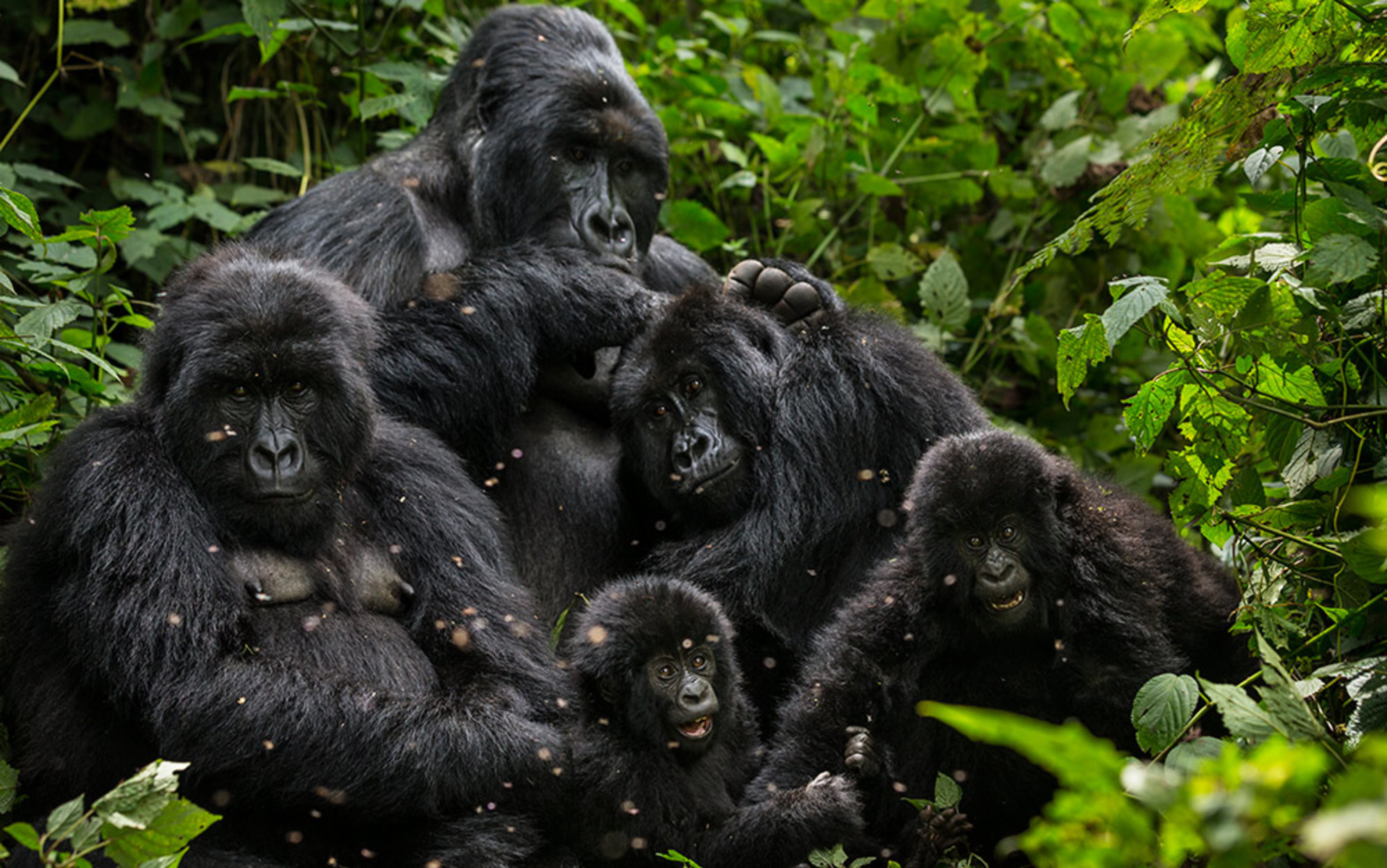
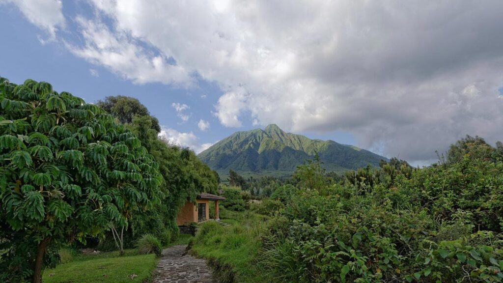
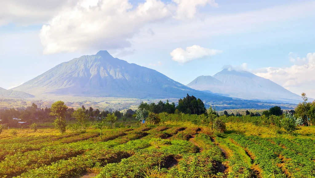
Mount Karisimbi, at 4,507 metres, is the highest peak in Rwanda and the highest of the eight Virunga volcanoes. It stands on the border of Rwanda and the Democratic Republic of Congo within Volcanoes National Park, the same park that shelters the endangered mountain gorilla families made famous by Dian Fossey’s research at the Karisoke Institute. A two-day guided ascent of Karisimbi through bamboo forest, hagenia-hypericum woodland, giant lobelias, and open Afroalpine moorland to a summit with 360-degree views across the Virunga range is, in itself, one of the outstanding hiking experiences of central Africa.
The Rwenzori Mountains, the Mountains of the Moon, Uganda’s UNESCO World Heritage alpine range, sit roughly 400 kilometres to the northeast. The highest summit, Margherita Peak on Mount Stanley, at 5,109 meters, is the third-highest point in Africa and one of only a handful of equatorial glaciated peaks remaining on the continent. The standard 8-day Kilembe Trail expedition takes you from the former copper-mining town of Kilembe through five vegetation zones and across the Stanley Plateau Glacier to a summit that towers 600 meters above Karisimbi and demands both physical preparation and glacier travel techniques.
Combined into a single 14-day expedition, arriving in Kigali, ascending Karisimbi, crossing into Uganda with an optional gorilla trekking stop at Bwindi Impenetrable Forest, and then completing the full Kilembe Trail to Margherita Peak, this itinerary represents one of the finest dual-summit mountain journeys available to a trekker anywhere in East Africa. Rwenzori Trekking Safaris designs and manages the Uganda section through an exclusive partnership with Rwenzori Trekking Services, coordinating the full expedition logistics so that the handover between the two mountain programs is seamless.

Rwenzori & Karisimbi Trekking Expedition Overview
Total Duration: 14 Days / 13 Nights
Mountains Summited: Mount Karisimbi (4,507m, Rwanda) + Margherita Peak, Mount Stanley (5,109m, Uganda)
Starting Point: Kigali International Airport, Rwanda
Finishing Point: Kasese / Entebbe International Airport, Uganda
Karisimbi Trail: Volcanoes National Park, Musanze, Rwanda (2 days on mountain)
Rwenzori Trail: Kilembe Trail, managed by Rwenzori Trekking Services (8 days)
Total Elevation Gain: ~4,200 m+ across both peaks
Countries Visited: Rwanda + Uganda
Difficulty: Challenging to Serious (high-altitude mountaineering)
Best Season: June–August | December–February
Group Size: 2–8 trekkers (private or small group)
Includes: guides, porters, all mountain meals, hut/camp accommodation, permits, and technical summit gear.
Mount Karisimbi (4,507 m), Rwanda’s Volcanic Roof.
Mount Karisimbi is a dormant stratovolcano standing 4,507 metres above sea level on the Rwanda-DRC border, within Volcanoes National Park. It is the highest of the eight Virunga volcanoes, higher than Mount Bisoke, Muhabura, Sabinyo, and the others that make up this extraordinary volcanic chain, and the 11th highest mountain in Africa. Its name comes from the Kinyarwanda word “amasimbi”, meaning “white shell” or “snow”, a reference to the frost and occasional snow that dusts its summit in cooler months.
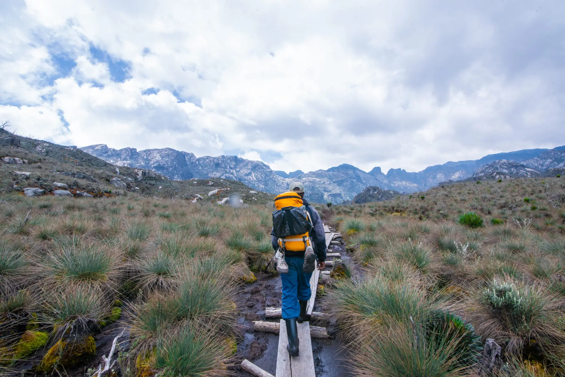
The standard Karisimbi ascent takes two days, starting from the Volcanoes National Park headquarters at Kinigi, near Musanze in northern Rwanda. Day one carries you from the park boundary at around 2,600 metres through dense bamboo forest, where a short detour visits Dian Fossey’s tomb at the Karisoke Research Center before climbing through hagenia-hypericum woodland and open moorland dotted with giant lobelias and senecio plants. After approximately six to eight hours of climbing, you arrive at the overnight mountain camp at 3,700 metres, where tents and basic facilities await under some of the most star-filled skies in central Africa. Day two begins before dawn, typically with a 5:30 AM wake-up for the final push to the summit. The last hour is steep, rocky, and at altitude, but no technical climbing skills are required. From the summit, on a clear day, the entire Virunga range spreads in every direction: Bisoke’s crater lake directly to the east, the smoking cone of Nyiragongo across the Congolese border to the west, and the rolling green hills of Rwanda’s thousand hills to the south.
The Karisimbi hiking permit costs $400 per person, which includes the guide, overnight accommodation on the mountain, and all park fees. The permit is arranged through the Rwanda Development Board and is coordinated as part of this combined expedition package.
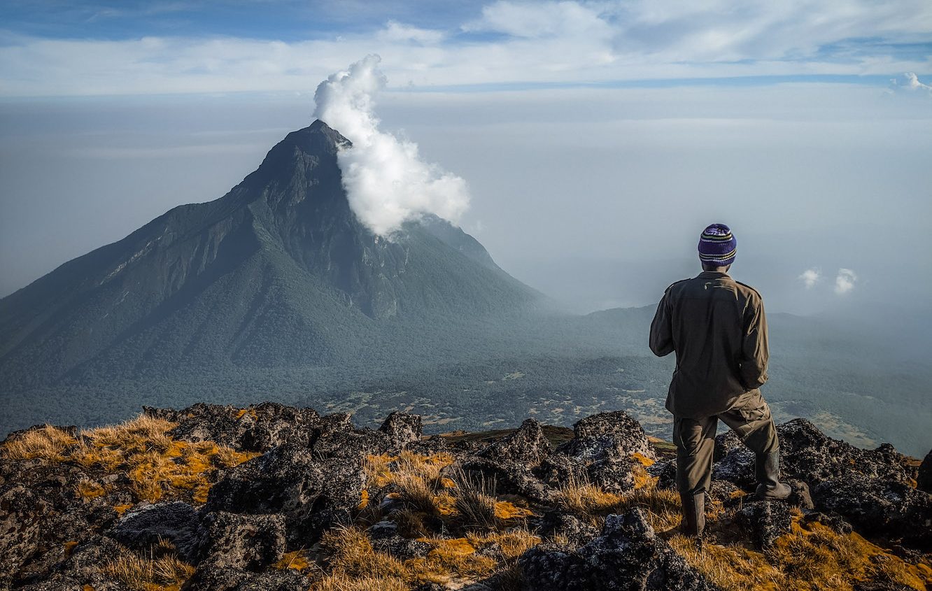
Margherita Peak, Mount Stanley (5,109 m), the Crown of the Rwenzori.
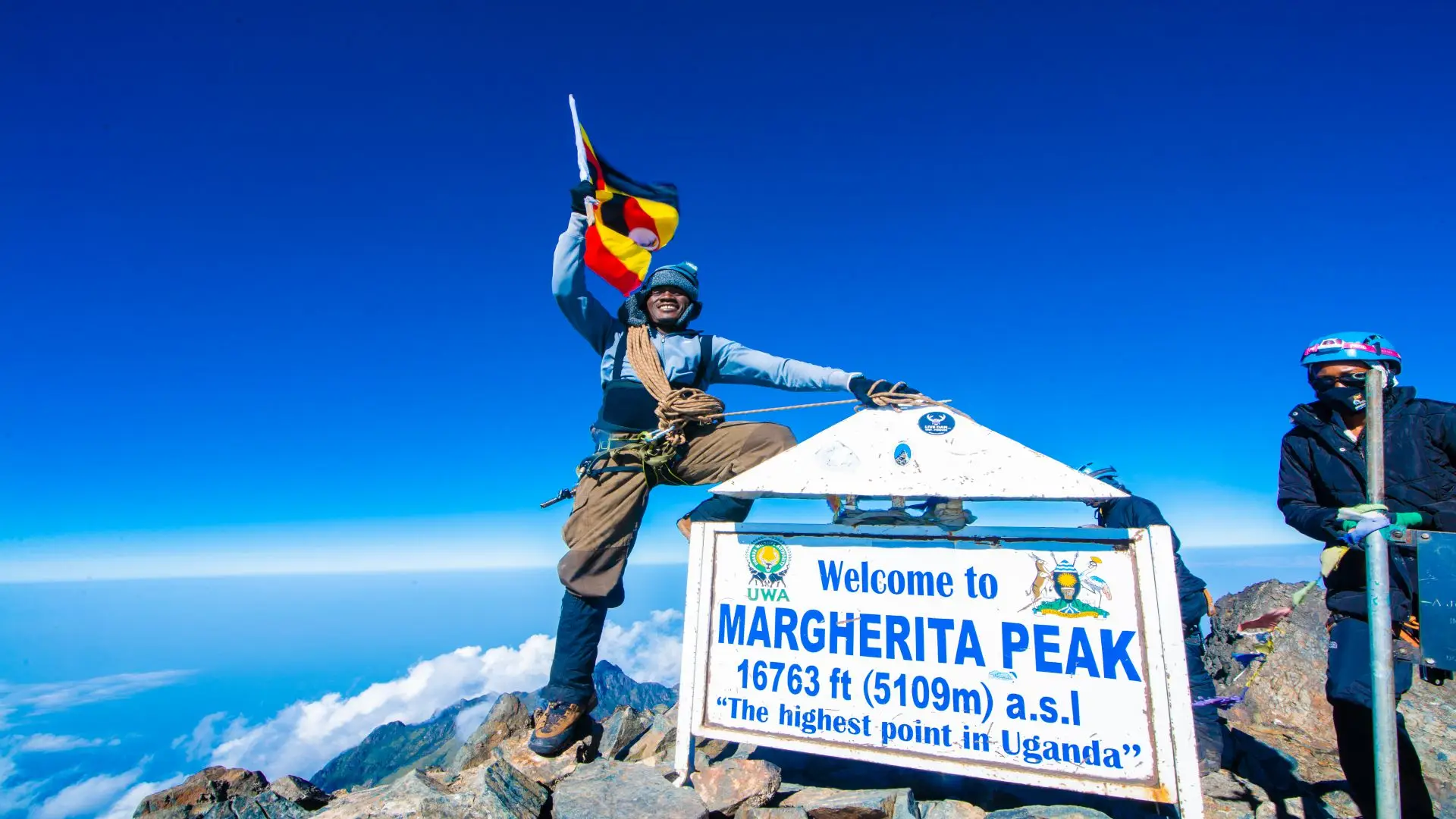
At 5,109 metres, Margherita Peak on Mount Stanley is the highest point in Uganda, the highest in the Democratic Republic of Congo, and the third-highest summit in Africa. It sits in the equatorial Rwenzori range, a block mountain rather than a volcano, formed by ancient tectonic uplift rather than volcanic activity. The glaciers that cap its upper ridges are among the last remaining equatorial glaciers in Africa, shrinking rapidly due to climate change but still present, still compelling, and still demanding genuine glacier travel technique to reach the summit.
The approach via the Kilembe Trail, managed exclusively by Rwenzori Trekking Services and accessible through Rwenzori Trekking Safaris, is an 8-day full loop from Kilembe town in Kasese, western Uganda. Unlike Karisimbi, which requires no technical mountaineering, Margherita involves crampons, ice axes, and roped team movement on the Stanley Plateau Glacier. The Uganda Wildlife Authority has installed a new glacier bridge and fixed climbing lines on the critical crevasse section, improving both safety and accessibility for guided parties. The approach ascends through five complete vegetation zones, culminating in a 2:30 AM departure from Margherita Camp (4,485 m) for the pre-dawn summit push. The summit experience, standing on the third-highest point in Africa on a glaciated peak close to the equator, is, by any measure, one of the greatest mountaineering achievements available to non-technical climbers.
The juxtaposition of the two peaks is part of what makes this combined expedition compelling. Karisimbi is a steep, open volcano with fast-changing weather and straightforward navigation once above the treeline. The Rwenzori summit is a glacier climb on a block mountain, technically more demanding, requiring summit equipment, but accessed through a landscape of extraordinary botanical and ecological complexity that Karisimbi does not replicate. Together they give you both faces of Africa’s high-altitude world.
Full Detailed Rwenzori & Karisimbi Trekking Expedition (Day-by-Day)
Day 1: Arrive Kigali, Transfer to Musanze / Volcanoes National Park.
Your expedition begins at Kigali International Airport, the clean and efficient entry point to Rwanda that has become one of the best-regarded airports in sub-Saharan Africa. After clearing immigration and collecting luggage, your Rwanda expedition guide meets you in the arrivals hall for the two-and-a-half to three-hour drive northwest to Musanze, the principal town of northern Rwanda and the gateway to Volcanoes National Park. The road passes through Rwanda’s famous thousand hills, terraced agricultural slopes that cascade down into valleys still threaded with morning mist, before the volcanic cones of the Virunga range begin to loom on the northern horizon.
Musanze is a comfortable, well-served town with a range of accommodation options from budget guesthouses to mid-range lodges and luxury properties with direct views of the volcanoes. Your group checks in, rests from the journey, and attends an evening briefing on the Karisimbi ascent: permit procedures, kit check, wake-up time, and what to expect on the mountain over the following two days. The evening is spent at altitude; Musanze sits at roughly 1,900 metres, which is the first gentle step in the acclimatisation sequence that the expedition has been designed around.
- Overnight: Five Volcanoes Boutique Hotel.
Day 2: Karisimbi Ascent: Bamboo Forest to High Mountain Camp (3,700m)
Wake-up is early. After breakfast, the drive from your lodge to the Volcanoes National Park headquarters at Kinigi for briefing and registration is followed by a second drive to the start of the Karisimbi trail at the park boundary, at around 2,600 meters, at the foot of the volcanic forest. Your Rwandan guide team will have assembled here: a lead ranger-guide, porters who carry camping equipment, food, and sleeping gear, and your personal daypack with water, waterproofs, and snacks.

The first hours of the ascent move through dense bamboo forest, tall, green, clicking overhead in any breeze, filtering the light into a soft, diffuse glow. This is mountain gorilla country, and while an actual sighting on the Karisimbi trail is not guaranteed, the signs of gorilla activity, fresh nests, broken bamboo, and dung are visible throughout the lower slopes. Dian Fossey’s tomb at the Karisoke Research Centre lies approximately 45 minutes from the trail junction; the optional detour adds an hour but is deeply worthwhile for anyone with an interest in the history of gorilla conservation.
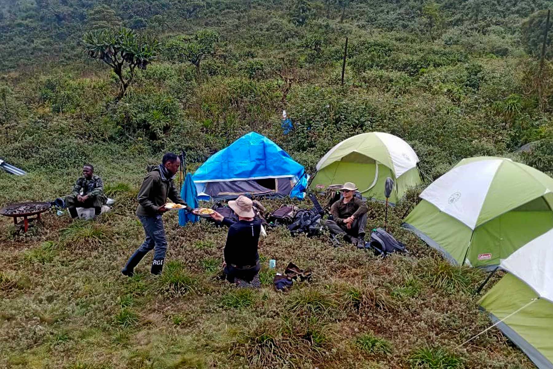
Above the bamboo, the vegetation transitions into hagenia-hypericum woodland, taller and more open, with twisted moss-covered trunks and shafts of light reaching the forest floor. The gradient steepens. By mid-afternoon, the forest gives way to an open Afroalpine moorland, where giant lobelias reach above head height and the views begin to open in every direction. The camp at 3,700 metres is reached after six to eight hours of walking: a basic but functional tent camp with a mess tent, prepared meals, and sleeping bags. Temperatures drop sharply at altitude once the sun goes down. The night sky at 3,700 metres on the Virunga range, without light pollution, is extraordinary.
- Altitude: 1,800 m → 3,700 m
-
Focus: Endurance and altitude adaptation
-
Overnight: Camping
Day 3: Karisimbi Summit Day (4,507m) and Descent to Musanze
Wake up at 5:30 AM. The final push to the summit begins in near-darkness, headlamps illuminating the rocky, volcanic path ahead. The final section from camp to summit is the steepest and most demanding of the entire Karisimbi ascent, with altitude and gradient combining to make progress feel slow. But the pace your guides set is deliberate: slow is safe at altitude, and the summit is reached with plenty in reserve for the long descent.
At the top, 4,507 metres above sea level, you are standing on Rwanda’s highest point. The entire Virunga range is spread around you: Bisoke with its perfectly circular crater lake directly to the east; the still-active Nyiragongo in the DRC to the west, its summit often obscured by its own emissions; Muhabura, Sabinyo, and the other Virunga peaks ranged to the east and north; and the rolling green highlands of Rwanda stretching south to the distant horizon. The cold at the summit can be fierce; wind, frost, and mist are all common even in the dry season, but the experience of standing on this volcanic summit, knowing that the Rwenzori and a second, higher summit await in the days ahead, gives the moment a particular intensity.
Descent from the summit to Musanze takes approximately six hours. By evening you are back at your lodge, with a hot shower, a hot meal, and the quiet satisfaction of the first magnificent summit crossed off. Rest is important tonight; tomorrow is a transit day, and the following eight days on the Rwenzori will demand everything you have.
- Altitude: 3,700m → 4,507m → 2,300m
-
Focus: Acclimatization and recovery
-
Overnight: Five Volcanoes Boutique Hotel.
Day 4: Transfer Musanze to Bwindi Impenetrable Forest (Optional Gorilla Trekking) or Direct to Kasese
The drive from Musanze in Rwanda to Kasese in western Uganda passes through some of the most scenically dramatic terrain in East Africa. The two main routing options depend on whether you have pre-booked a gorilla trekking permit at Bwindi Impenetrable Forest, one of the finest wildlife experiences on the continent and, given the geographical logic of the route, an addition that requires only one or two extra days.
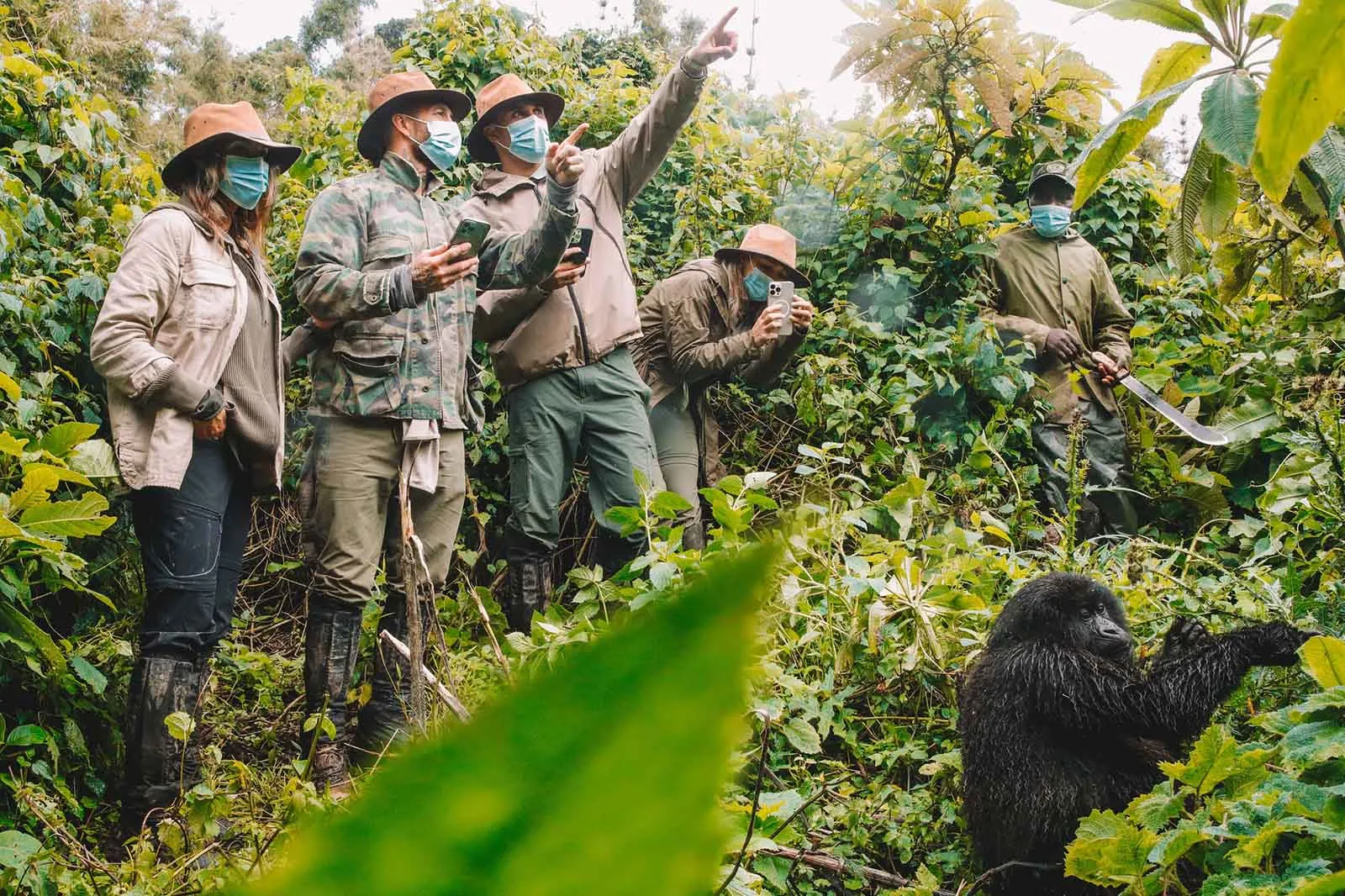
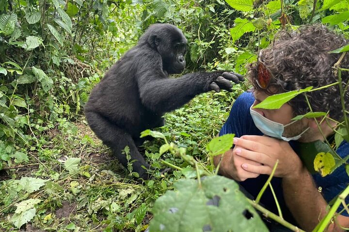
If gorilla trekking is included, the drive takes you southwest to Kabale in southwestern Uganda before climbing into the Bwindi Impenetrable Forest National Park, home to approximately half of the world’s remaining mountain gorillas across its four sectors of Buhoma, Ruhija, Rushaga, and Nkuringo. An afternoon arrival allows you to rest, brief for the following morning’s gorilla permit activity, and absorb the extraordinary forest atmosphere of Bwindi. Gorilla trekking permits for Uganda are priced at approximately $800 per person and must be booked well in advance. The one-hour encounter with a habituated gorilla family in the impenetrable forest is an experience that permanently recalibrates your understanding of primate intelligence and forest wilderness.
If gorilla trekking is not included, the direct drive from Musanze to Kasese takes approximately six to seven hours via the border crossing at Katuna/Gatuna or Cyanika/Bunagana, passing through the Ankole highlands of southwestern Uganda before descending to the Kasese basin with the Rwenzori’s snow-capped ridgeline visible to the northwest. Either routing arrives at the Kilembe base or Kasese accommodation in preparation for the mountain.
Day 5: Kilembe: Arrival, Briefing, and Expedition Preparation
This is the transition day between the two mountain programmes. If you arrived directly from Rwanda the previous afternoon, Day 5 is a rest, acclimatisation, and logistics day at Kilembe base camp. If the gorilla trekking add-on was taken, you drive from Bwindi to Kasese/Kilembe today, a three-to-four-hour journey through the Rwenzori foothills with the mountain growing larger and more defined with every kilometre.
At the Kilembe base, the Rwenzori Trekking Services team conducts a comprehensive expedition briefing: the eight-day itinerary in detail, altitude management protocols, weather expectations, summit day requirements, and kit inspection. All technical summit equipment, crampons, ice axes, helmets, harnesses, ropes, and rubber boots, is issued here and checked thoroughly. Your guide team is introduced: a lead certified mountain guide, an assistant guide, and a porter team drawn from the Bakonjo community, the indigenous people of the Rwenzori foothills whose relationship with the mountain spans generations. A final check of sleeping bags, rain gear, and layering systems is conducted, and any gaps in kit are addressed.
Dinner at the base, an early night, and the knowledge that, in the morning, the Rwenzori begins.
-
Overnight: Kilembe Base Camp
Day 6: Kilembe Trailhead (1,450m) to Sine Camp (2,596m)
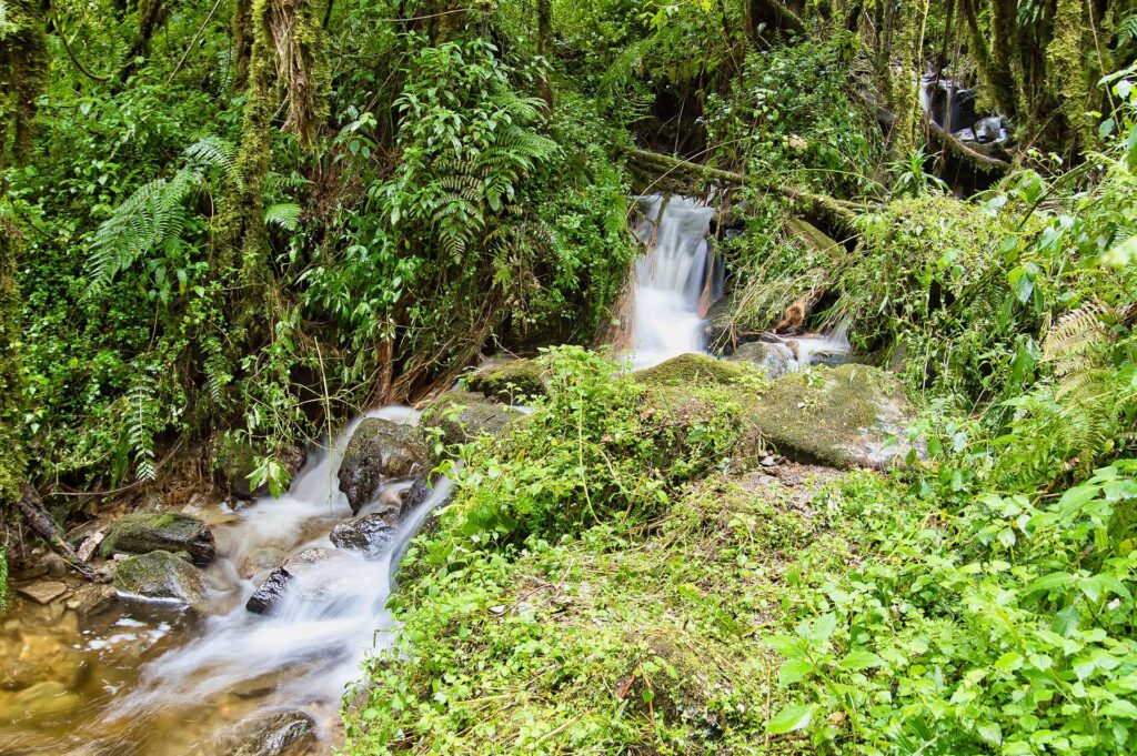
The Kilembe Trail begins at 1,450 metres, lower than Musanze, and several hundred metres below the start of the Karisimbi Trail. After two days on a volcano and a transit across two countries, there is something profoundly satisfying about starting again at the bottom, in the warmth of the Rwenzori’s lower forest. The contrast with the volcanic Virunga landscape is immediate and total: where Karisimbi’s lower slopes were bamboo-dense and relatively open, the Rwenzori’s Afro-Montane Forest is ancient, layered, and complex, a cathedral of Podocarpus and Prunus africana draped in climbing plants and vibrating with birdsong.

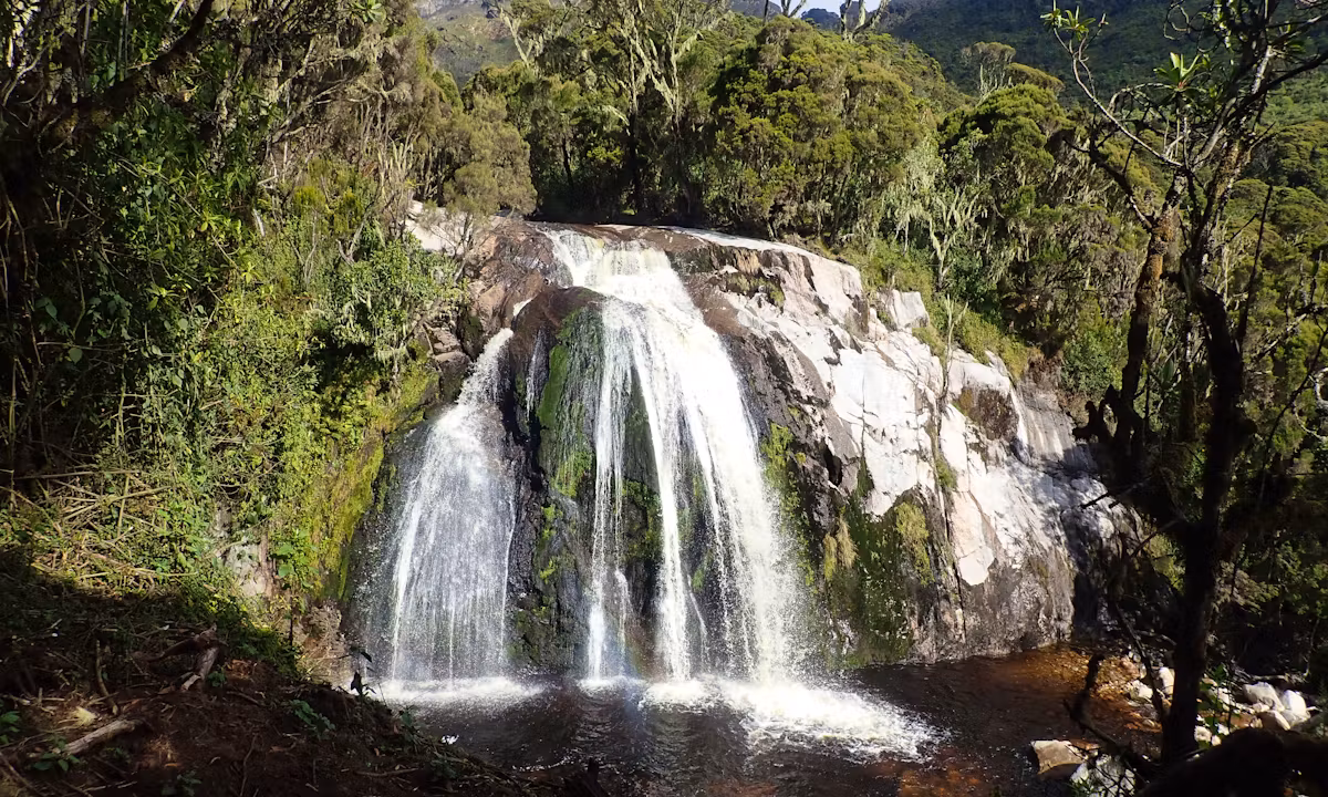
The trail climbs steadily for five to six hours through increasingly lush and mossy forest, crossing the Mubuku River on log bridges and navigating root-strewn path sections that demand careful footing. Blue monkeys and black-and-white colobus move through the high canopy. Three-horned chameleons, prehistoric-looking and impossibly slow, inhabit the understory. Just 200 metres before Sine Hut, Enock’s Falls drops off a moss-covered cliff face in a curtain of white water. Sine Camp at 2,596 metres is your first Rwenzori night: colder than the valley, quieter than anywhere you have been in days, with the sound of running water from every direction.
-
Altitude: 1,450 m → 2,596 m
-
Overnight: Sine Camp
Day 7: Sine Camp to Mutinda Camp (3,588m) via Kalalama Camp
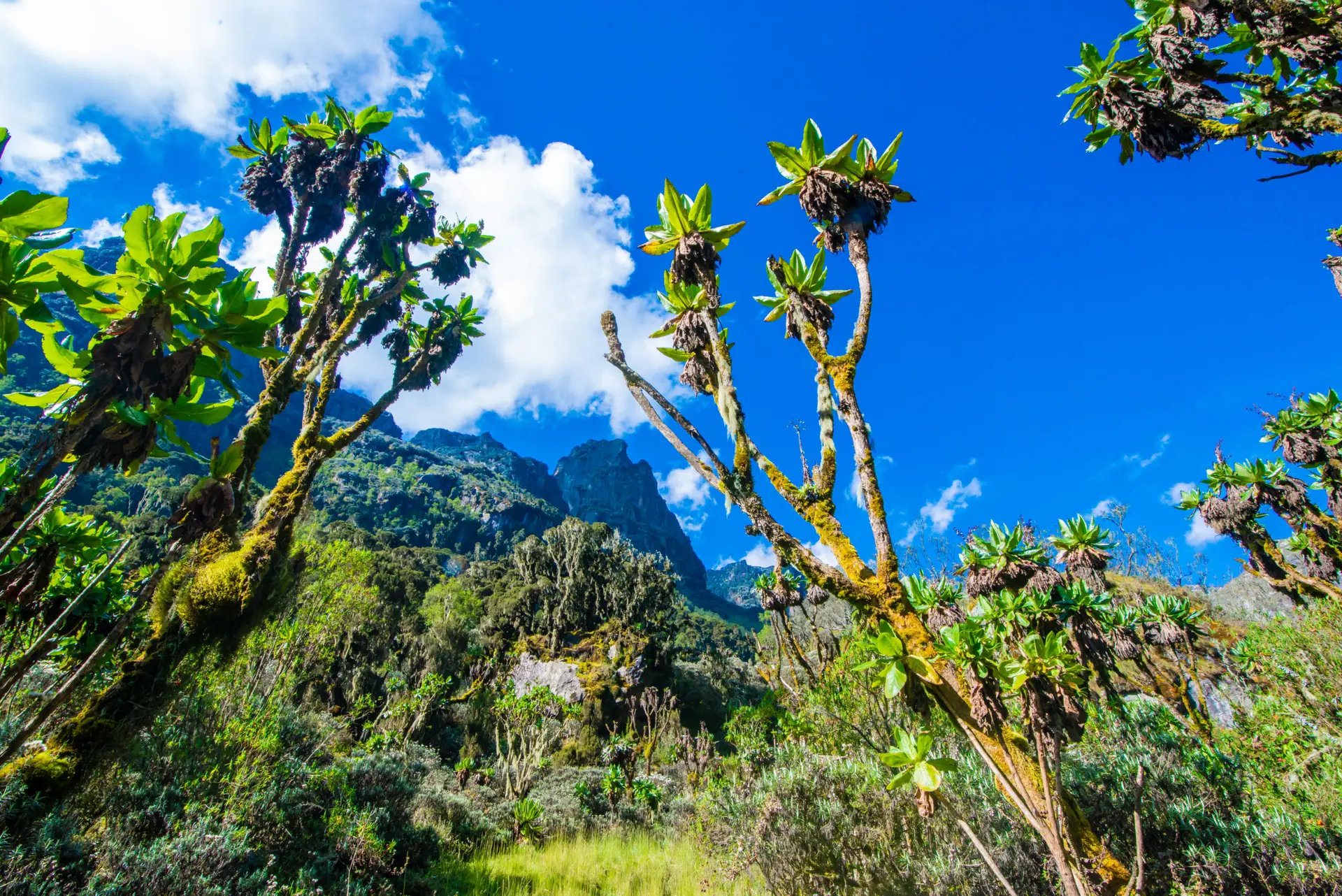
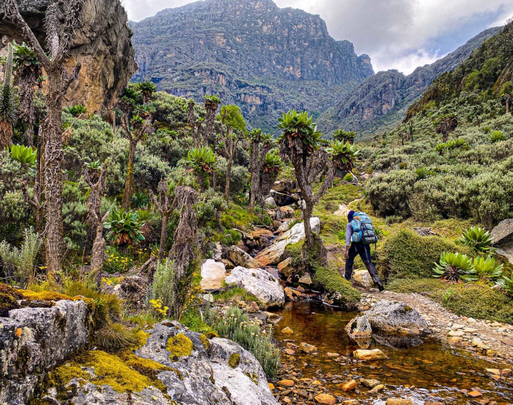
The second day on the Rwenzori carries you into the mountain’s most surreal botanical zone. The bamboo-mimulopsis section begins shortly after leaving Sine; it is steep and high-stepped and, in the wet season, coated in slippery mud that demands full concentration. Above the bamboo, the giant heather forest takes over, and the result is the Rwenzori’s botanical signature, the landscape that makes even experienced mountain trekkers stop and look: tree heathers fifteen metres tall, buried under metres of old man’s beard lichen (Usnea) and every species of mountain moss, their trunks bent into extraordinary shapes by decades of ice weight.

Kalalama Camp, located at 3,147 meters, is a midday rest stop with views back over the valley. From here, the trail climbs through ever-deepening heather and moss forests, crossing small rivers and waterfalls before emerging at Mutinda Camp at 3,588 metres. In the afternoon, you can take an optional ascent to Mutinda Lookout at 3,975 meters, which is a round trip of two hours, to enjoy a sweeping panorama across southern Rwenzori and down to Kasese and Lake George. After two days on Karisimbi, the altitude at Mutinda is familiar territory, and the acclimatisation benefits of the lookout hike are real.
- Altitude: 2,596m → 3,588m
-
Overnight: Mutinda Camp.
Day 8: Mutinda Camp to Bugata Camp (4,062m)
Day eight of the combined expedition, day three on the Kilembe Trail, takes you definitively into the alpine zone. The trail crosses the broad Mutinda Valley through open moorland dotted with everlasting flowers and Rwenzori’s famous giant lobelia (Lobelia wollastonii), whose towering flower spikes reach five meters above the surrounding vegetation. The Namusangi Valley section, at 3,840 meters, features vertical waterfalls visible from the trail and, looking back, the receding pyramid of Mutinda Peak, framed by the valley walls.

Bugata Camp at 4,062 metres is above four kilometres for the first time in the Rwenzori. This is higher than the Karisimbi summit, and the altitude at Bugata is noticeably more serious; wind, cold, and the reduced light of altitude all contribute to a different quality of mountain experience. Your acclimatisation from the Karisimbi ascent is working in your favour; most trekkers with Karisimbi under their belts find Bugata’s altitude genuinely manageable. Early sleep, maximum hydration, and a hot meal are the evening’s prescription.
- Altitude: 3,588 m → 4,062 m
-
Overnight: Bugata Camp.
Day 9: Bugata Camp to Hunwick's Camp (3,974m) via Bamwanjara Pass (4,450m)
This is the day the Rwenzori reveals its greatest single viewpoint. The climb from Bugata to Bamwanjara Pass at 4,450 meters, higher than the Karisimbi summit and any point reached so far on this expedition, crests onto a ridge from which the three towering peaks of the Rwenzori open simultaneously: the ice-capped massif of Mount Stanley with Margherita hidden in its upper ramparts, the dark pyramid of Mount Baker to the west, and the profile of Weismann’s Peak standing between them. An emergency shelter sits at the pass; in deteriorating weather, it provides temporary refuge while the guide makes a descent decision.

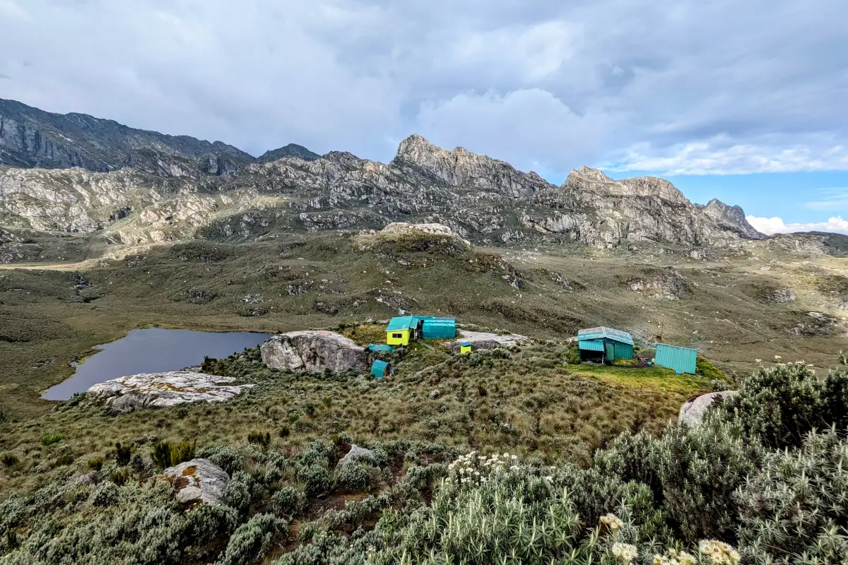
Hunwick’s Camp, at 3,974 meters, sits on the edge of a wide valley, with sight lines to Stanley, Baker, Weismann’s Peak, and McConnell’s Prong above. A small, bold population of Malachite Sunbirds inhabits the giant lobelia stands around the camp, their iridescent plumage flashing against the grey-green moorland. This is one of the finest camp settings in the entire Rwenzori, and after the demanding Bamwanjara traverse, arriving here feels like landing at exactly the right place.
- Altitude: 4,062m → 4,450m → 3,974m
-
Overnight: Hunwick’s Camp.
Day 10: Hunwick's Camp to Margherita Camp (4,485m) via Lake Kitandara
The approach to the final staging camp before the summit is deliberately short in distance but significant in elevation. The route descends from Hunwick’s to cross the valley floor, passing Lake Kitandara, a deep glacial lake whose dark, still surface and lush surrounding vegetation provide one of the most atmospheric moments of the entire Kilembe Trail. The lake sits at the foot of the Stanley massif, and looking up from its shore toward the glaciated ridgeline above is a direct reminder of what the morning will require.
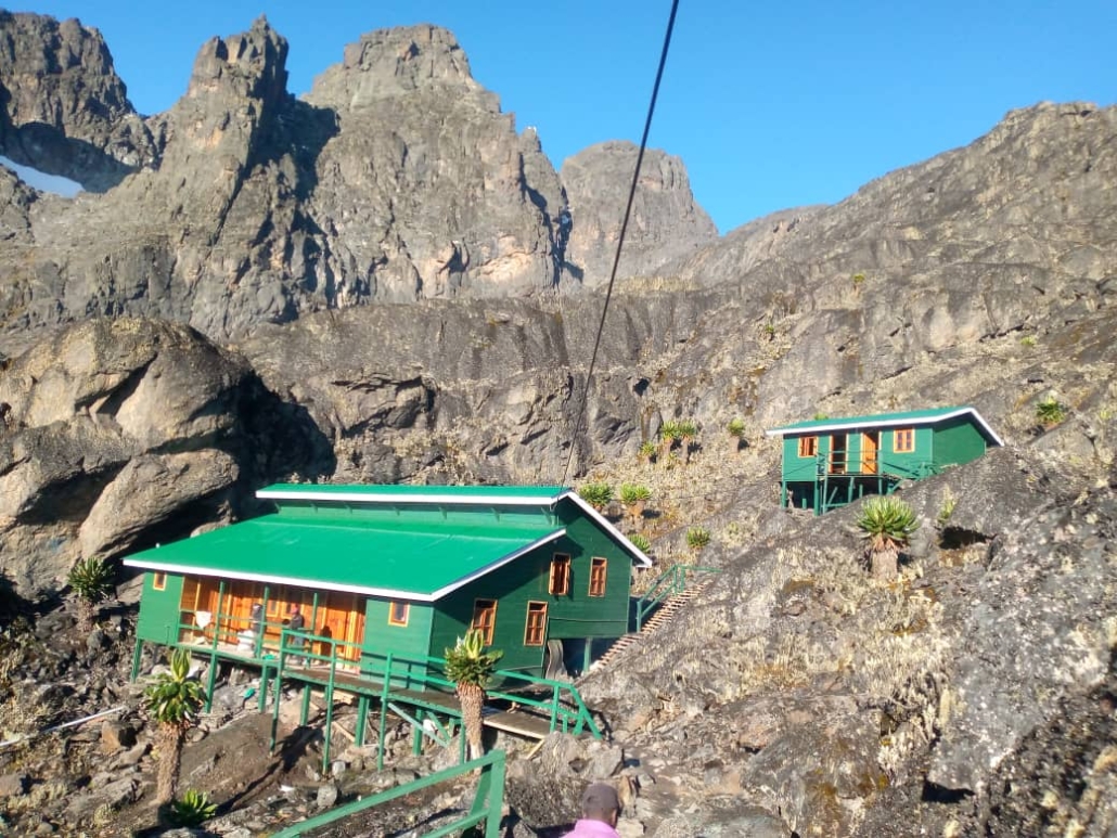
From Kitandara, the trail climbs over Scott Elliott’s Pass and continues up the ridge to Margherita Camp, at 4,485 metres. The camp is tucked between giant boulders that provide natural wind protection. In 1906, the Duke of Abruzzi camped at this same location after the first ascent of Margherita. The afternoon is given to rest, equipment check, and the summit briefing: 2:30 AM departure, crampons on before the glacier, and turnaround at 10:00 AM regardless of position. Eat well, sleep early, and trust the preparation.
- Altitude: 3,974 m → 4,485 m
- Overnight: Margherita Camp.
Day 11: Summit Day: Margherita Peak (5,109m) and Descent to Hunwick's Camp..
Wake up at 2:00 AM. Departure at 2:30 AM. The darkness is total, with your headlamp beam being the only light on the ice ahead. The Stanley Plateau Glacier requires crampons and ice axes from this point, and the guide ropes the team together. The gradient steepens as you cross the plateau toward the base of the Margherita Glacier, the most challenging technical section of the climb, with angles that can reach 60° and crevasse hazards that the Uganda Wildlife Authority’s new fixed lines help to navigate safely. The ascent from camp to Margherita Peak typically takes four to five hours.
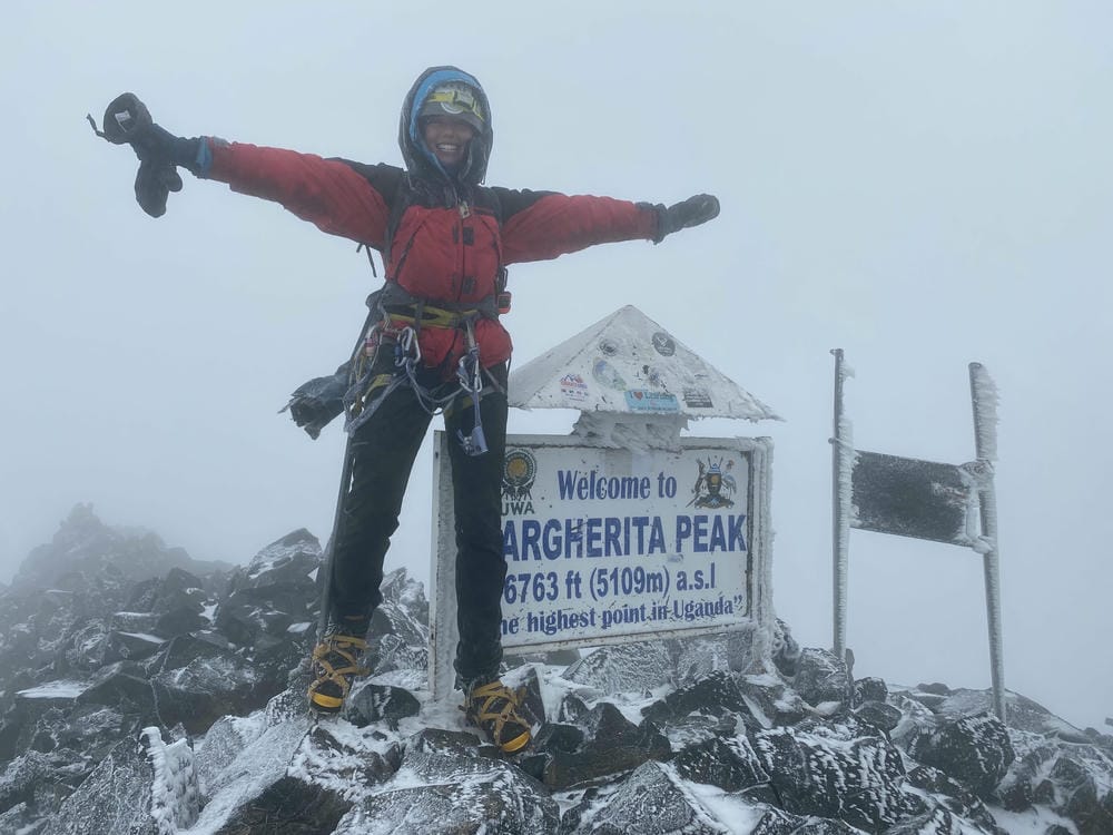
At the summit, which is 5,109 meters, you are standing 602 meters above the Karisimbi summit you reached earlier in this same expedition. You are at the third-highest point in Africa. The Congo basin stretches west in an unbroken green canopy. The entire Rwenzori range spreads north and south. On a clear morning, the horizon in every direction holds nothing but the sky, mountains, and the curved surface of the earth below you. This site is the summit of a combined expedition that has carried you across two countries, through equatorial forest, volcanic moorland, bamboo zones, heather forest, Afroalpine meadows, and two glaciated peaks. Your guide presents a genuinely earned certificate.
The descendant from the summit returns to Margherita Camp and then continues down to Hunwick’s Camp at 3,874 metres. The full summit day from Margherita Camp and back to Hunwick’s typically runs ten to twelve hours. It is the hardest day of the combined expedition and the most unforgettable.
- Altitude: 4,485m → 5,109m → 3,874m
-
Overnight: Hunwick’s Camp
Day 12: Hunwick's Camp to Kiharo Camp (3,460m) via Oliver's Pass (4,505m)
The Kilembe Trail’s descent route is one of its greatest assets, a route of extraordinary wilderness quality that most of the trekking world has never encountered. From Hunwick’s Camp, the trail climbs a ridge toward McConnell’s Prong before arriving at Oliver’s Pass at 4,505 metres, actually the highest pass crossed on the entire expedition, sitting even higher than Bamwanjara Pass and 2 metres below the Karisimbi summit. From Oliver’s Pass, the views of the Three Peaks and Scott Elliott’s Pass below give a final broad perspective on the mountain before the descent begins.

The descent follows the Nyamwamba Valley, a route of remote, quiet beauty that traces the river system from its glacial origins to the confluence with the Kilembe River, whose waters flow downstream through Kasese and ultimately to Lake George in Queen Elizabeth National Park. The trail weaves between ancient moraines, bogs, and dense heather forest before arriving at Kiharo Camp at 3,460 metres, a hidden valley campsite surrounded by cliffs with Kiharo Falls, a spectacular waterfall just 200 metres from the camp, audible through the night.
- Altitude: 3,874m → 4,505m → 3,460m
-
Overnight: Kiharo Camp
Day 13: Kiharo Camp to Kilembe Trailhead and Transfer to Kasese
The final 16 kilometres of trails descend the Nyamwamba Valley through some of the richest wildlife habitats on the entire route. Rwenzori red duikers are frequently spotted in forest clearings, and the series of spectacular cascades below Kiharo fills the valley with sound as the river picks up gradient and volume. The trail climbs briefly to a high ridge with broad valley views before descending through dense woodland to Forest View Camp for lunch, then continuing down to the Kilembe park gate.
At the gate, your Rwenzori Trekking Services certificate is presented, one of the most honestly earned pieces of paper in East African mountaineering and the formal completion of an expedition that has now crossed two countries and two mountain ranges. A vehicle from Rwenzori Trekking Safaris transfers your group back to Kasese for the first hot shower and flat bed since Day 5.
- Altitude: 3,460 m → 1,450 m
-
Overnight: Kilembe Base Camp.
Day 14: Kasese to Entebbe International Airport: Departure
The final day is a transfer day. The drive from Kasese to Entebbe International Airport covers approximately five to six hours via Fort Portal and the Kampala-Masaka highway, or four hours to Queen Elizabeth National Park for those extending into a wildlife safari.
The road east from Kasese passes under the full southern flank of the Rwenzori range, the same mountain you have just spent eight days inside, and seeing it from the valley floor after walking its highest ridges gives a perspective that no amount of photographs can adequately prepare you for. At the airport, the expedition closes.
Two summits. Two countries. One journey that earns the name.
Why This Expedition Stands Apart: The Case for the Dual-Summit Combination
Plenty of operators offer Rwenzori trekking, and plenty offer Karisimbi hiking. The combination is far rarer, and for good reason: it requires coordinating two entirely separate mountain management systems across two countries, with a complex logistics chain running between them. But the combination is greater than the sum of its parts for reasons that go beyond simple geography.
Karisimbi and the Rwenzori represent two fundamentally different types of African high mountain: one volcanic and open, with rapid changes in vegetation and the atmospheric weight of Dian Fossey’s gorilla conservation legacy; the other a tectonic block mountain, densely vegetated, ancient in a different way, and topped by one of the last equatorial glaciers in Africa. The contrast in geology, ecology, and character between the two ranges makes the combined expedition a more complete picture of East African mountain systems than either could provide alone.
The acclimatisation argument is also compelling. Two days on Karisimbi at up to 4,507 metres provide an excellent physiological foundation for Rwenzori’s higher demands. Trekkers who complete Karisimbi first arrive at the Kilembe Trail with their bodies already adapted to sustained effort at altitude, their gear already fully tested in mountain conditions, and their psychological confidence in their own high-altitude performance established. The transition from the Virunga volcanic environment to the Rwenzori forest environment enriches every subsequent day on the second range, as these two mountain ecosystems are as different as can be, despite both carrying UNESCO designations.
The Optional Gorilla Trekking Extension at Bwindi Impenetrable Forest
For trekkers with the time and budget, the geographical position of Bwindi Impenetrable Forest between the Virunga range and the Rwenzori makes it a logical addition to this expedition. Bwindi, in southwestern Uganda, is home to approximately half of the world’s surviving mountain gorillas, roughly 500 individuals across four gorilla trekking sectors. A permit-based one-hour encounter with a habituated gorilla family in the impenetrable forest is routinely described as the most profound wildlife experience available anywhere in Africa.
Adding one or two nights at Bwindi between the Karisimbi descent and the Kasese arrival extends the expedition by one to two days and adds an entirely different dimension to the trip: from volcanic highland to dense lowland forest, from summit to canopy, from mountain glacier to gorilla family. The contrast reinforces what makes this part of Africa unlike anywhere else: the density of extraordinary experiences within a compact geographical area. Gorilla trekking permits for Uganda are currently priced at approximately $800 per person and must be booked well in advance. Rwenzori Trekking Safaris coordinates the full logistics of the Bwindi extension as part of the combined expedition package.
Fitness, Training, and Preparation for the Combined Expedition.
The combined Karisimbi-Rwenzori expedition is a serious undertaking that demands genuine physical preparation. You will be trekking for up to twelve days consecutively at altitudes ranging from 1,450 to 5,109 meters in weather conditions that can include cold rain, wind, mist, and subzero temperatures at high camp. The summit day on Margherita involves glacier travel that adds technical demands above what is required on Karisimbi.
As a minimum preparation standard, trekkers should be able to walk six to nine hours continuously on steep, uneven terrain, carrying a daypack of eight to twelve kilograms, for at least five consecutive days. Prior multi-day trekking experience is strongly recommended, not because the navigation is complex (your guides handle all route-finding) but because understanding how your body responds to sustained daily effort over multiple days is genuinely useful information for managing pace, nutrition, and recovery on the mountain. A structured training program beginning eight to twelve weeks before departure that incorporates regular hill walking, stair climbing, or running is the minimum preparation standard.
Altitude sickness is the primary risk on both mountains. The expedition’s acclimatisation profile is carefully structured to manage this risk, starting at moderate altitude in Rwanda, ascending to 4,507 metres over two days, and then descending and re-ascending through the Kilembe Trail’s well-designed altitude ladder. Before departure, discuss the use of Diamox (acetazolamide) for altitude prophylaxis with your physician. Our guides are trained in altitude illness recognition and carry supplemental oxygen. The 10:00 AM turnaround rule on Margherita summit day is non-negotiable and has a direct bearing on safety.
Essential Kit for the Combined Expedition
Packing for a 14-day dual-summit expedition across two mountain systems requires careful thought. The key principle is the same on both mountains: layering, waterproofing, and not skimping on footwear. The conditions on Karisimbi and the Rwenzori are different; the Virunga’s volcanic terrain is steeper and more open, while the Rwenzori’s forest sections are more sheltered but wetter, but the core kit requirements overlap almost completely.
Your base layer should be synthetic or merino wool, never cotton, which holds moisture and kills warmth when wet. A substantial mid-layer fleece, a fully waterproof hardshell jacket with taped seams, and a down or synthetic insulated jacket for camp and summit use are all essential. For the lower body, waterproof trail trousers or softshell trousers with waterproof over-trousers are the combination that works on both mountains. Waterproof, ankle-supporting boots that have been properly broken in before the expedition departs are non-negotiable; blisters and boot failure at altitude have ended more expeditions than weather or fitness. Trekking poles for the steep descents on both mountains save knees and improve stability on wet root and rock sections.
For the Margherita summit specifically: a warm sleeping bag rated to at least minus ten degrees Celsius for the Rwenzori high camps, a down or heavy synthetic insulated jacket for the glacier, warm gloves, a balaclava, and sunglasses for glacier glare are all essential. Rwenzori Trekking Services provides crampons, ice axes, helmets, and harnesses at the Kilembe trailhead; you don’t need to bring your own. For Karisimbi, the same sleeping bag and insulation are required for the 3,700-metre camp night; the summit day is cold but does not require technical glacier equipment.
Best Time for the Combined Expedition
Both mountains have aligned dry seasons that make planning this combined expedition straightforward. The primary dry window, June through August, is the best period for both Karisimbi and the Rwenzori, offering lower rainfall, firmer trails, better visibility at altitude, and the highest summit success rates on Margherita. This month is also the peak booking season for gorilla trekking at Bwindi, so Bwindi permits should be secured as far in advance as possible if the gorilla extension is planned.
The secondary dry window, late December through February, is the second-best option. December and January conditions on both mountains are generally reliable, and this window avoids the peak-season crowds of July-August while still offering excellent summit prospects. Christmas and New Year on the Rwenzori glacier is a genuinely extraordinary experience for those whose family schedules allow it.
The wet seasons, April-May and October-November, make both mountains significantly more demanding. Karisimbi’s trails become deeply muddy, and its summit is frequently obscured by cloud; the Rwenzori’s forest sections are at their most demanding, with river crossings requiring more careful management. Experienced trekkers who can only travel in these windows are accommodated by Rwenzori Trekking Safaris year-round, but first-time high-altitude trekkers are strongly advised to target the dry season windows.
What’s Included in the Package Fees
- Professional, licensed mountain guide for the full 7 days
- Rwanda Development Board hiking permit
- Licensed Uganda Wildlife Authority ranger guide
- Dedicated porter team, personal gear and camp supplies
- All meals (breakfast, lunch, dinner, hot drinks)
- All accommodation
- Complimentary use of rubber boots (Rwenzori essential)
- National Park entry fees and climbing permits
- Summit achievement certificate upon completion
- Emergency first aid kit and oxygen on mountain
- Pre-trek equipment and safety briefing
Not Included in the Package Fees:
- International flights and Uganda entry visa
- Transfers to/from Nyakalengija trailhead (available on request)
- Personal trekking gear: sleeping bag, jacket, hiking boots, poles
- Warm and waterproof clothing (essential; see packing list)
- Medical evacuation and travel insurance (required)
- Personal expenses and snacks on the mountain
- Tips and gratuities for guides and porters (encouraged)
- Alcoholic beverages
- Any costs arising from itinerary changes due to weather or medical reasons
Book Your Slot
Respond within Minutes
From
$1,400
per person
- Duration 14 Days / 13 Nights
- Group Size 1–8 people
- Start Point Kigali
- Departures Year-round
- Summits Mount Karisimbi & Margherita Peak
30% booking fee. Free cancellation up to 60 days before departure. We respond within Minutes.
Our Popular Rwenzori Treks
Magheritah Peak (8 Days Kilembe Trail)
$1705 Per Person
Mutinda LookOut (4 Days)
$645 Per Person
Short Magherita Hike (5 Days Central Circuit)
$1200 Per Person
Rwenzori Hike (7 Days Central Circuit)
$1400 Per Person
Frequently Asked Questions: Rwenzori Mountains & Mount Karisimbi Combined Expedition
What is the Mount Rwenzori and Mount Karisimbi trekking expedition?
The Mount Rwenzori and Mount Karisimbi trekking expedition is a 14-day combined dual-summit adventure covering two of East Africa’s greatest mountain objectives in a single integrated itinerary. The expedition begins in Rwanda with a 2-day ascent of Mount Karisimbi (4,507 m) in Volcanoes National Park, Rwanda’s highest peak and the highest of the Virunga volcanoes, before crossing into Uganda for the 8-day Kilembe Trail expedition to Margherita Peak (5,109 m) on Mount Stanley in the Rwenzori Mountains. The combined itinerary is designed around the acclimatisation benefit of ascending Karisimbi first, using the Virunga ascent to prepare the body for the higher and more technically demanding Rwenzori summit. It represents one of the finest dual-summit mountain journeys in Africa.
How high is Mount Karisimbi and how does it compare to Margherita Peak?
Mount Karisimbi stands at 4,507 metres above sea level and is the highest peak in Rwanda, the highest of the eight Virunga Range volcanoes, and the 11th highest mountain in Africa. Margherita Peak on Mount Stanley in the Rwenzori Mountains stands at 5,109 metres, 602 metres higher than Karisimbi, making it the highest point in Uganda, the highest in the Democratic Republic of Congo, and the third-highest summit in Africa after Kilimanjaro (5,895 m) and Mount Kenya (5,199 m). The two summits represent fundamentally different types of mountain: Karisimbi is a dormant stratovolcano accessed via forest and open moorland with no technical climbing required; Margherita is a glaciated tectonic block mountain that requires crampons, ice axes, and roped team movement on the Stanley Plateau Glacier.
How long does the combined Rwenzori and Karisimbi expedition take?
This trek is rated challenging. You should be able to hike 6–8 hours per day for multiple consecutive days with a daypack on uneven, muddy, and rocky terrain. Summit day is the most demanding, with up to 13 hours of combined hiking, glacier travel, and high-altitude effort. We recommend three to four months of preparation, including regular long-distance hiking with elevation gain, cardiovascular training (running or cycling), and ideally one or two altitude hikes above 3,000 m before your Rwenzori departure.
Do I need mountaineering experience for this combined expedition?
Mount Karisimbi does not require technical mountaineering experience; it is a demanding hike over steep and sometimes muddy terrain at altitude, but no ropes, crampons, or ice axes are involved. Margherita Peak on the Rwenzori requires glacier travel using crampons and ice axes, with movement done on roped teams under guide supervision.
Prior crampon experience is helpful but not strictly required, as the Rwenzori Trekking Services guides provide full instruction at Margherita Camp before summit day. What is essential for a full combined expedition is strong cardiovascular fitness, prior multi-day trekking experience, and comfort with sustained physical effort at altitudes above 4,000 metres. The Karisimbi ascent earlier in the expedition serves as excellent physical and psychological preparation for the more demanding Rwenzori summit.
What gear and equipment do I need to bring personally?
We provide all technical summit equipment (crampons, ice axes, ropes, harnesses, and helmets) and complimentary rubber boots for the boggy sections. You are responsible for personal trekking gear: a quality sleeping bag rated to -10°C, waterproof hiking boots, waterproof jacket and trousers, insulating mid-layer, base layers (moisture-wicking), warm hat, gloves, trekking poles, headlamp, sunscreen, sunglasses, and personal medications. A full detailed packing list is provided upon booking. Gear hire is available locally in Kasese for items you don’t own.
Is there a gorilla trekking option included in the Rwenzori-Karisimbi expedition?
Gorilla trekking is an optional extension to the combined expedition, not a standard inclusion. The geographical routing of the expedition from Rwanda’s Volcanoes National Park to Uganda’s Rwenzori Mountains passes within two to three hours of Bwindi Impenetrable Forest, home to approximately half of the world’s remaining mountain gorillas and one of the finest wildlife experiences available anywhere in Africa. Adding one or two nights at Bwindi extends the total expedition by one to two days.
Gorilla trekking permits for Uganda are currently approximately $800 per person and must be booked well in advance. Rwenzori Trekking Safaris coordinates the Bwindi extension as part of the combined package on request.
What food is provided on the mountain?
Our cook team prepares three hot meals per day throughout the trek. Breakfasts typically include porridge, eggs, bread, fruit, and hot drinks (tea, coffee, and cocoa). Lunches are packed meals eaten on the trail or at camp. Dinners are hot, filling dishes such as rice, pasta, beans, lentils, vegetables, and meat where available.
Special dietary requirements (vegetarian, vegan, gluten-free) can be accommodated with advance notice. High-altitude days often suppress appetite; our cooks are experienced at providing calorie-dense, appealing food to keep energy levels high.
What is the best time of year for the Rwenzori and Karisimbi combined expedition?
The best time for the combined expedition is during the shared dry seasons of both mountains: June to August (primary dry season) and late December through February (secondary dry season). Both Karisimbi and the Rwenzori have clearer trails, better visibility, lower rainfall, and higher summit success rates during these windows. July and August are the most reliable months overall. The dry season also coincides with the best gorilla trekking conditions at Bwindi. The rainy seasons, April-May and October-November, make both mountains significantly more demanding and are generally not recommended for a first combined expedition. Rwenzori Trekking Safaris operates the Kilembe Trail year-round, and expert advice on current conditions for any planned travel date is available on request.
How many people will be in my group, and can I book a private trek?
Groups range from 1 to 12 people. We accept solo climbers, couples, and small groups. Private, exclusive treks are available; simply indicate these options in your booking request. Smaller groups receive more personalized guide attention on summit day, which is particularly valuable during the glacier section. The guide-to-climber ratio is maintained to ensure safety and a quality experience regardless of group size.
Is Travel and Medical Evacuation Insurance Required?
Comprehensive travel insurance that specifically covers high-altitude trekking (to at least 5,200 m) and helicopter medical evacuation is not just recommended; it is strongly required for all participants. Evacuation from the Rwenzori Mountains is challenging and potentially expensive, although it rarely happens.
Policies from providers such as World Nomads, Battleface, or Allianz typically cover this level of activity. Please confirm your policy covers technical mountaineering and helicopter evacuation before arriving. Evidence of insurance may be requested at the time of booking confirmation.
What is included in the Rwenzori and Karisimbi expedition cost?
The all-inclusive expedition package covers the Rwanda Development Board. Karisimbi hiking permit ($400 per person), ranger-guide services and overnight mountain camp on Karisimbi, all meals and porter services on Karisimbi, road transfers in Rwanda and Uganda Wildlife Authority national park permit fees for the Rwenzori, all Kilembe Trail mountain hut accommodation fees, certified lead and assistant guides, a full porter team, three hot meals per day on the Rwenzori (Days 6–13), technical summit equipment (crampons, ice axes, helmets, harnesses, and rubber boots), first aid equipment including supplemental oxygen, and Kasese-trailhead vehicle transfers. Not included: international flights to Kigali and from Entebbe; Rwandan and Ugandan visas; personal travel insurance (mandatory; must cover glacier travel above 5,000 m); personal expenses; gratuities; and pre- andpost-expedition hotel accommodation.
How hard is Mount Karisimbi compared to the Rwenzori Mountains?
Mount Karisimbi is a challenging high-altitude hike but is significantly less technically demanding than a Margherita Peak summit on the Rwenzori. Karisimbi requires no mountaineering equipment, no glacier travel, and no roped team movement. It is a steep, sustained hike over two days through dense forest and open moorland to 4,507 metres, with an overnight camp at 3,700 metres. The demands are cardiovascular fitness and altitude tolerance rather than technical skill.
The Rwenzori’s Margherita summit adds glacier travel with crampons and ice axes, a 2:30 AM summit start, and a total summit day of ten to twelve hours from Margherita Camp at 4,485 metres. The Rwenzori is also more remote, has more complex weather, and its approach requires eight days rather than two. For a combined expedition, doing Karisimbi first is strongly recommended; it builds altitude acclimatisation and mountain confidence that are directly applicable to the harder Rwenzori summit.